|
REFINE
Browse All : Images by Williamson, R.S.
1-50 of 50
Author
[Williamson, R.S., Heuer, W.H.]
Full Title
Report upon the Removal of Blossom Rock in San Francisco Harbor, California by R.S. Williamson, Major, Corps of Engineers, Brevet Lieutenant Colonel, U.S.A. and W. H. Heuer, Lieutenant Corps of Engineers. 1870. Published by the Authority of the Secretary of War. Washington: Government Printing Office. 1871.
List No
2992.035
Note
The is the flip book reader version of this atlas, showing all pages ot text and maps.
Author
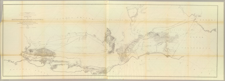
Williamson, R.S.
Full Title
From San Francisco Bay to the Northern Boundary of California from Explorations and Surveys made under the direction of the Hon. Jefferson Davis Secretary of War by Lieut. R.S. Williamson, U.S. Topl. Engrs. and Lieut. H.L. Abbot, U.S. Topl. Engrs., H.C. Fillebrown, J. Young and C.D. Anderson, Assts. 1855. Explorations and surveys for a railroad route from the Mississippi River to the Pacific Ocean. War Department. Routes in Oregon and California. Map No. 1. Drawn by John Young.
List No
0693.024
Note
Map extends north from the tip of the San Francisco Bay to the 42nd parallel. The areas around the bay and the northern section near Lassen and Mt. Shasta are the most extensively drawn. Uncolored. List of authorities included.
Author
Williamson, R.S.
Full Title
From the Northern Boundary of California to the Columbia River from Explorations and Surveys made under the direction of the Hon. Jefferson Davis Secretary of War by Lieut. R.S. Williamson, U.S. Topl. Engrs. and Lieut. H.L. Abbot, U.S. Topl. Engrs., H.C. Fillebrown, J. Young and C.D. Anderson, Assts. 1855. Explorations and surveys for a railroad route from the Mississippi River to the Pacific Ocean. War Department. Routes in Oregon and California. Map No. 2. Drawn by John Young. Engd. by Selmar Siebert.
List No
0693.025
Note
Uncolored map covering the area from the 42nd parallel to the mouth of the Columbia River. Includes a list of the other surveys referenced.
Author
[Abbot, Henry L., Williamson, R.S.]
Full Title
Routes in Oregon and California. Profiles sheet no. 1 from Benicia to Fort Reading and from Fort Reading to Vancouver; from explorations and surveys made under the direction of Hon. Jefferson Davis, Sec. of War by Lieut. R.S. Williamson, U.S. Topl. Engrs. and Lieut. H.L. Abbot, U.S. Topl. Engrs, H.C. Fillerbrown, C.D. Anderson and J. Young assts. 1855. (1861)
List No
0693.026
Note
Uncolored profiles. Horizontal scale 1:15,206.4.
Author
[Abbot, Henry L., Williamson, R.S.]
Full Title
Routes in Oregon and California. Profiles sheet no. 2 from the head of Des Chutes Valley to Vancouver and from Vancouver to Fort Reading; from explorations and surveys made under the direction of Hon. Jefferson Davis, Sec. of War by Lieut. R.S. Williamson, U.S. Topl. Engrs. and Lieut. H.L. Abbot, U.S. Topl. Engrs, H.C. Fillerbrown, C.D. Anderson and J. Young assts. 1855. (1861)
List No
0693.027
Note
Uncolored profiles. Horizontal scale 1:15,206.4.
Author
Williamson, R.S.
Full Title
General Map of Explorations and Surveys in California made under the direction of the Hon. Jefferson Davis, Secretary of War by Lieut. R.S. Williamson, Topogl. Engr. assisted by Lieut. J.G. Parke, Topl. Engr. and Mr. Isaac Williams Smith, Civ. Engr. 1853. Explorations and Surveys for a Rail Road Route from the Mississippi River to the Pacific Ocean. War Department. Routes in California to connect with the routes near the 32nd and 35th parallels. Engr. by Selmar Siebert.
List No
0693.040
Note
A north/south view of California from the San Francisco Bay to San Diego. The railway line is shown extending as far east as Fort Yuma. Without color.
Author
Williamson, R.S.
Full Title
Map of Passes in the Sierra Nevada from Walker's Pass to the Coast Range: from Explorations and Surveys made under the direction of the Hon. Jefferson Davis, Secretary of War by Lieut. R.S. Williamson Topl. Engr. assisted by Lieut. J.G. Parke Topl. Engr. and Mr. Isaac Williams Smith, Civ. Engr. 1853. Explorations and Surveys for a Rail Road Route from the Mississippi River to the Pacific Ocean. War Department. Routes in California to connect with the routes near the 32nd and 35th parallels. Engraved by Selmar Siebert.
List No
0693.041
Note
Map uncolored.
Author
Williamson, R.S.
Full Title
Map and Profile of the Canada de las Uvas; from Explorations and Surveys made under the direction of the Hon. Jefferson Davis, Secretary of War by Lieut. R.S. Williamson Topl. Engr. assisted by Lieut. J.G. Parke Topl. Engr. and Mr. Isaac Williams Smith, Civ. Engr. 1853. Explorations and Surveys for a Rail Road Route from the Mississippi River to the Pacific Ocean. War Department. Routes in California to connect with the routes near the 32nd and 35th parallels. Engr. by Selmar Siebert.
List No
0693.042
Note
Uncolored.
Author
Williamson, R.S.
Full Title
Map and Profile of the Tejon Pass; from Explorations and Surveys made under the direction of the Hon. Jefferson Davis, Secretary of War by Lieut. R.S. Williamson Topl. Engr. assisted by Lieut. J.G. Parke Topl. Engr. and Mr. Isaac Williams Smith, Civ. Engr. 1853. Explorations and Surveys for a Rail Road Route from the Mississippi River to the Pacific Ocean. War Department. Routes in California to connect with the routes near the 32nd and 35th parallels. Engr. by Selmar Siebert.
List No
0693.043
Note
Uncolored.
Author
Williamson, R.S.
Full Title
Sheet no. 1. Profiles of passes in the Sierra Nevada; from Explorations and Surveys made under the direction of the Hon. Jefferson Davis, Secretary of War by Lieut. R.S. Williamson, Topl. Engr. assisted by Lieut. J.G. Parke, Topl. Engr. and Mr. Isaac Williams Smith, Civ. Engr. 1853. Explorations and Surveys for a Rail Road Route from the Mississippi River to the Pacific Ocean. War Department. Routes in California to connect with the routes near the 32nd and 35th parallels. (1861)
List No
0693.044
Note
Uncolored profiles. Vertical scale 1:24,000. Contents: Profile of Walker's Pass -- Profile of Hum-pa-ya-mup Pass -- Profile of Tah-ee-chay-pah Pass -- Profile of San Fernando Pass -- Profile of route from summit of Tah-ee-chay-pah Pass to the Tejon Depot Camp -- Profile of New Pass.
Author
Williamson, R.S.
Full Title
Sheet no. 2. Profiles of passes in the Sierra Nevada; from Explorations and Surveys made under the direction of the Hon. Jefferson Davis, Secretary of War by Lieut. R.S. Williamson, Topl. Engr. assisted by Lieut. J.G. Parke, Topl. Engr. and Mr. Isaac Williams Smith, Civ. Engr. 1853. Explorations and Surveys for a Rail Road Route from the Mississippi River to the Pacific Ocean. War Department. Routes in California to connect with the routes near the 32nd and 35th parallels. (1861)
List No
0693.045
Note
Uncolored profiles. Vertical scale 1:24,000. Contents: Profile of San Francisquito Pass -- Profile of Cajon Pass -- Profile of San Gorgonio Pass -- Profile of the Colorado Desert from Station 15 of San Gorgonio Pass to the wagon road -- Profile of Warner's Pass.
Author
Williamson, R.S.
Full Title
Military Map of the South Eastern Part of Oregon, South Western Part of Idaho, North Eastern Part of California, and Northern Part of Nevada. North Eastern Part of California & South Eastern Part of Oregon Made from actual Surveys by Lt. Col. Drew and Lt. Col. Williamson, the other parts compiled from other reliable sources. 1866.
List No
1464.000
Note
1 map on 6 sheets. Full size photo reproduction of original in Bancroft Library. First detailed map of the Owyhee country and the area of Northeastern Nevada. Britton and Rey map of the same year taken from this and Wheat 1160. Relief shown by form lines. Shows drainage, and roads.
Author
[United States. Army. Corps of Engineers, Williamson, R.S.]
Full Title
Topographical map of California, Nevada, Oregon and part of Idaho. Prepared from field surveys and other reliable data. Under the direction of Bvt. Lt. Col. R.S. Williamson, Corps of Engineers, U.S.A. Drawn by W.B. Hyde. 1867.. Julius Bien & Co., Lith., N.Y. (1891-1895)
List No
1780.134
Note
Col. map in 3 segments. Relief shown by hachures. At head of title "Essayons." "General map."
Author
Williamson, R.S.
Full Title
Map of Parts of California, Nevada, Oregon And Idaho Territory, Showing the Routes to the Humboldt And Reese River Mines, Surproise Valley, Owyhee Mines, Idaho, etc. etc. Compiled from the latest Information and comprising the Results of Explorations ... By Bvt. Lieut. Col. R.S. Williamson, U.S.A. Maj. Of Engrs. John D. Hoffmann, C.E. & Topographer, In 1865, Lieut. W.H. Heuer, U.S. Engr. In 1866, U.S. Engineers Office, San Francisco, 1866. Published with Official Consent by Britton & Rey, San Francisco. ... (Reproduction).
List No
2115.000
Note
1 map on 4 sheets. Photo reproduction of photo reproduction. Original in LOC. First published map to show good detail of the Owyhee country and the proposed road from Silver City to Ft. McDermid via three forks of the Owyhee. Scale 12 Miles to One inch. Relief shown by hachures. See Wheat 1160.
Author
[Williamson, R.S., Heuer, W.H.]
Full Title
(Covers to) Report upon the Removal of Blossom Rock in San Francisco Harbor, California by R.S. Williamson, Major, Corps of Engineers, Brevet Lieutenant Colonel, U.S.A. and W. H. Heuer, Lieutenant Corps of Engineers. 1870. Published by the Authority of the Secretary of War. Washington: Government Printing Office. 1871.
List No
2992.001
Note
Dark green linen covered boards embossed with gilt text, "Removal of Blossom Rock. San Francisco Harbor."
Author
[Williamson, R.S., Heuer, W.H.]
Full Title
(Title Page to) Report upon the Removal of Blossom Rock in San Francisco Harbor, California by R.S. Williamson, Major, Corps of Engineers, Brevet Lieutenant Colonel, U.S.A. and W. H. Heuer, Lieutenant Corps of Engineers. 1870. Published by the Authority of the Secretary of War. Washington: Government Printing Office. 1871.
List No
2992.002
Author
[Williamson, R.S., Heuer, W.H.]
Full Title
(Half Title Page to) Report upon the Removal of Blossom Rock in San Francisco Harbor, California by R.S. Williamson, Major, Corps of Engineers, Brevet Lieutenant Colonel, U.S.A. and W. H. Heuer, Lieutenant Corps of Engineers. 1870. Published by the Authority of the Secretary of War. Washington: Government Printing Office. 1871.
List No
2992.003
Note
Illustration of the explosion on Blossom Rock.
Author
[Williamson, R.S., Heuer, W.H.]
Full Title
(Transmittal Letter for) Report upon the Removal of Blossom Rock in San Francisco Harbor, California by R.S. Williamson, Major, Corps of Engineers, Brevet Lieutenant Colonel, U.S.A. and W. H. Heuer, Lieutenant Corps of Engineers. 1870. Published by the Authority of the Secretary of War. Washington: Government Printing Office. 1871.
List No
2992.004
Author
[Williamson, R.S., Heuer, W.H.]
Full Title
(Text Page) Removal of Blossom Rock, in San Francisco Harbor, California.
List No
2992.005
Author
[Williamson, R.S., Heuer, W.H.]
Full Title
(Text Page) Removal of Blossom Rock, in San Francisco Harbor, California.
List No
2992.006
Author
[Williamson, R.S., Heuer, W.H.]
Full Title
(Text Page) Removal of Blossom Rock, in San Francisco Harbor, California.
List No
2992.007
Author
[Williamson, R.S., Heuer, W.H.]
Full Title
(Text Page) Removal of Blossom Rock, in San Francisco Harbor, California.
List No
2992.008
Author
[Williamson, R.S., Heuer, W.H.]
Full Title
(Text Page) Removal of Blossom Rock, in San Francisco Harbor, California.
List No
2992.009
Author
[Williamson, R.S., Heuer, W.H.]
Full Title
(Text Page) Removal of Blossom Rock, in San Francisco Harbor, California.
List No
2992.010
Author
[Williamson, R.S., Heuer, W.H.]
Full Title
(Text Page) Removal of Blossom Rock, in San Francisco Harbor, California.
List No
2992.011
Author
[Williamson, R.S., Heuer, W.H.]
Full Title
(Text Page) Removal of Blossom Rock, in San Francisco Harbor, California.
List No
2992.012
Author
[Williamson, R.S., Heuer, W.H.]
Full Title
(Text Page) Removal of Blossom Rock, in San Francisco Harbor, California.
List No
2992.013
Author
[Williamson, R.S., Heuer, W.H.]
Full Title
(Text Page) Removal of Blossom Rock, in San Francisco Harbor, California.
List No
2992.014
Author
[Williamson, R.S., Heuer, W.H.]
Full Title
(Text Page) Removal of Blossom Rock, in San Francisco Harbor, California.
List No
2992.015
Author
[Williamson, R.S., Heuer, W.H.]
Full Title
(Text Page) Removal of Blossom Rock, in San Francisco Harbor, California.
List No
2992.016
Author
[Williamson, R.S., Heuer, W.H.]
Full Title
(Text Page) Removal of Blossom Rock, in San Francisco Harbor, California.
List No
2992.017
Author
[Williamson, R.S., Heuer, W.H.]
Full Title
(Text Page) Removal of Blossom Rock, in San Francisco Harbor, California.
List No
2992.018
Author
[Williamson, R.S., Heuer, W.H.]
Full Title
(Text Page) Removal of Blossom Rock, in San Francisco Harbor, California.
List No
2992.019
Author
[Williamson, R.S., Heuer, W.H.]
Full Title
(Text Page) Removal of Blossom Rock, in San Francisco Harbor, California.
List No
2992.020
Author
[Williamson, R.S., Heuer, W.H.]
Full Title
(Text Page) Removal of Blossom Rock, in San Francisco Harbor, California.
List No
2992.021
Author
[Williamson, R.S., Heuer, W.H.]
Full Title
(Text Page) Removal of Blossom Rock, in San Francisco Harbor, California.
List No
2992.022
Author
[Williamson, R.S., Heuer, W.H.]
Full Title
(Text Page) Removal of Blossom Rock, in San Francisco Harbor, California.
List No
2992.023
Author
U.S. Coast Survey
Full Title
Plate I. Entrance to San Francisco Bay, California, showing the Position of Blossom Rock from a Coast Survey Chart, 1859. Scale: 1:50,000.
List No
2992.024
Note
Shows developed areas of San Francisco and Sausalito.
Author
[Williamson, R.S., Heuer, W.H.]
Full Title
Plate II. Sketch showing the Positions and Results of the Experimental Blasts on Blossom Rock, Sheet 1... Plan.
List No
2992.025
Note
Soundings taken by Edward Cordell.
Author
[Williamson, R.S., Heuer, W.H.]
Full Title
Plate III. Sketch showing the Positions and Results of the Experimental Blasts on Blossom Rock, Sheet 2.
List No
2992.026
Note
Shows cross-sections of the effects of the blasts.
Author
Alexander, B.S.
Full Title
Plate IV. Project for blowing up Blossom Rock, San Francisco Harbor, Sheet 1 by Brt. Brig. Gen. B.S. Alexamder; U.S.A.....
List No
2992.027
Note
Shows plan and cross-sections of the placement of charges.
Author
Alexander, B.S.
Full Title
Plate V. Project for blowing up Blossom Rock, San Francisco Harbor, Sheet 2 by Brt. Brig. Gen. B.S. Alexamder; U.S.A.....
List No
2992.028
Note
Shows plan and cross-sections of the placement of charges.
Author
Von Schmidt, Allexey W.
Full Title
Plate VI. Project for removing Blossom Rock, San Francisco Harbor, by A.W. Von Schmidt.....
List No
2992.029
Note
Shows cross-sections of the placement of charges.
Author
Von Schmidt, Allexey W.
Full Title
Plate VII. Plan of the Rock showing the excavated Chamber ready for the blast. Removal of Blossom Rock, San Francisco Harbor, Sheet 1 by the Contractor, A.W. Von Schmidt.....
List No
2992.030
Note
Shows cross-section and plan of the excavation.
Author
Von Schmidt, Allexey W.
Full Title
Plate VIII. Plan of the Cribwork and Boiler-Iron Shaft. Removal of Blossom Rock, San Francisco Harbor Sheet 2, by the Contractor, A.W. Von Schmidt.....
List No
2992.031
Note
Shows cross-section and plan of the shaft.
Author
Von Schmidt, Allexey W.
Full Title
Plate IX. Plan of Chamber showing the distribution of Powder-packages. Removal of Blossom Rock, San Francisco Harbor Sheet 3, by the Contractor, A.W. Von Schmidt.....
List No
2992.032
Note
Shows cross-sections of the powder barrel and Abel-fuse.
Author
Von Schmidt, Allexey W.
Full Title
Plate X. View of the Scow and Rake. Removal of Blossom Rock, San Francisco Harbor Sheet 4, by the Contractor, A.W. Von Schmidt.....
List No
2992.033
Note
Shows various views and details of rake and sounding-float.
Author
[Heuer, W.H., Von Schmidt, Allexey W.]
Full Title
Plate XI. Removal of Blossom Rock, San Francisco Harbor Sheet 5, by the Contractor, A.W. Von Schmidt ... Map showing the Depth of Water on Blossom Rock as established by Survey of April 1871 made by Lieut. W.H. Heuer, U.S. Engrs.
List No
2992.034
Note
Shows soundings in both feet (brown area) and fathoms.
Author
[Gibbes, C.D., Holt, Warren]
Full Title
(Covers to) Map of the States of California And Nevada. Carefully Compiled from the Latest Authentic Sources. California By Julius H. Von Schmidt, Arthur W. Keddie, And C.D. Gibbes, C.E.'s. Nevada By Chas. Drayton Gibbes C.E. Comprising Information obtained from the U.S. Coast And Land Surveys; State Geological Surveys, By Prof. J.D. Whitney; Railroad Surveys And The Results Of Explorations Made By Brevet Lieut. Col. R.S. Williamson, U.S.A., Henry DeGroot, C.D. Gibbes, And Others. Published by Warren Holt. No. 717 Montgomery St. San Francisco, Cal. 1881. Entered ... 1876 by Warren Holt ... Washington, D.C. S.B. Linton, Engr. & Lithogr. 148-1/2 S. 4th Street, Philadelphia ...
List No
4231A
Author
[Gibbes, C.D., Holt, Warren]
Full Title
Map of the States of California And Nevada. Carefully Compiled from the Latest Authentic Sources. California By Julius H. Von Schmidt, Arthur W. Keddie, And C.D. Gibbes, C.E.'s. Nevada By Chas. Drayton Gibbes C.E. Comprising Information obtained from the U.S. Coast And Land Surveys; State Geological Surveys, By Prof. J.D. Whitney; Railroad Surveys And The Results Of Explorations Made By Brevet Lieut. Col. R.S. Williamson, U.S.A., Henry DeGroot, C.D. Gibbes, And Others. Published by Warren Holt. No. 717 Montgomery St. San Francisco, Cal. 1881. Entered ... 1876 by Warren Holt ... Washington, D.C. S.B. Linton, Engr. & Lithogr. 148-1/2 S. 4th Street, Philadelphia ...
List No
4231.001
Note
This edition is not in Vogdes (he lists editions of 1869, 1876, and 1888). The copyright date is 1876, so it is probably similar to that edition. There are many changes, as one would hope (or expect) between this and the 1869 edition, both in graphic composition and topography. The map has been completely reengraved by S.B.Linton (the original engraver) and shows much of the General Land Office surveys. It is so full of detail as to be difficult to read in many areas. Two views are added: the Capital-Nevada, and University-California. The 1888 edition is reengraved completely yet again (WH's copy). This copy belonged to Lewis M. Clement, Chief Engineer of the Atlantic & Pacific Railroad. The inside of the case flap closure reads "Lewis M. Clement, Chief Engineer of the Atlantic & Pacific Railroad - Office: Safe Deposit Building Room 8 - San Francisco, Cal." in calligraphic manuscript. The map is slightly trimmed at the bottom (affecting only the decorative border) in order to fit into his custom brown cloth case 28x17. Map has outline color, is in two sheets (Northern and Southern halves), each undissected and mounted on linen.
1-50 of 50
|