|
Author
W. & A.K. Johnston Limited
Full Title
(Covers to) List of geographical and educational works, comprising atlases, maps, globes, illustrative diagrams, etc. Published by W. and A. K. Johnston, Geographers and Engravers to the Queen, 4, St Andrew Square, Edinburgh.
List No
14279.001
Note
Covers to W. & A. K. Johnston's List of geographical and educational works, published in Edinburgh, 1858. Bound in beige paper. Front cover features an image of Atlas with the globe on his shoulders. Includes an extended statement of responsibility: Agents in London: E. Stanford, Charing Cross; Groombridge adn Son, Paternoster Row. Glasgow: James Lumsden and Son. Aberdeen: L. and J. Smith. Back cover has an advertisement for "Johnston's modern globes : with the most recent discoveries". Unfolded to 22 x 27. (First page number inferred.)
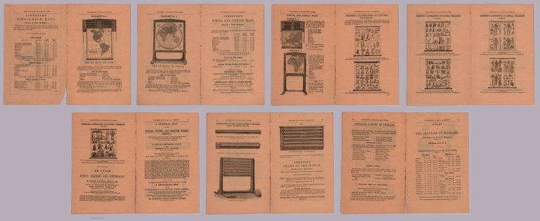
Author
W. & A.K. Johnston Limited
Full Title
(Composite Text to) List of geographical and educational works, comprising atlases, maps, globes, illustrative diagrams, etc. Published by W. and A. K. Johnston, Geographers and Engravers to the Queen, 4, St Andrew Square, Edinburgh.
List No
14279.002
Note
Composite of fourteen text pages to W. & A. K. Johnston's List of geographical and educational works, catalog published in Edinburgh, 1858. Contains advertisements with lists of available works, including illustrations of examples, such as "Set of maps in case" on page 3. (Date taken from front cover.)
Author
W. & A.K. Johnston Limited
Full Title
(Covers to) Edinburgh cabinet atlas.
List No
14296.001
Note
Covers to Edinburgh cabinet atlas by W. & A.K. Johnston Limited, 1839. Bound in black board with brown leather spine and corners. Front cover and spine both have gilded title, as well as ornamentation. With embossed - recessed - decorative pattern.
Author
W. & A.K. Johnston Limited
Full Title
(Title Page to) Dedicated to Her Most Gracious Majesty The Queen. The Edinburgh cabinet atlas comprising maps illustrating the modern geography of every country of the world and the most interesting portions of ancient geography; constructed from the latest & most authentic sources. Edinburgh, W. & A.K. Johnston Engravers & Printers to The Queen. Glasgow Robert Weir; Lumsden & Son: London, Whittaker & Co. Dublin, John Cumming: Paris J.P. Aillaud. 1839.
List No
14296.002
Note
Title page to Edinburgh cabinet atlas by W. & A.K. Johnston Limited, 1839. Includes a dedication to the Queen of England, the imprint and an engraved illustration of a unicorn and lion.
Author
W. & A.K. Johnston Limited
Full Title
(Contents to) Contents. Sketch of the history of geography, and progress of modern discovery. Index to the principal cities, countries, &c. in the world, with tables of longitude and latitude, and reference numbers to each plate.
List No
14296.003
Note
Table of contents to Edinburgh cabinet atlas by W. & A.K. Johnston Limited, 1839. Lists four ancient maps and forty-one modern maps, amounting to a total of forty-five. In addition, lists the Table of the comparative heights of the principal mountains in the world and the Table of the comparative lengths of the principal rivers in the world. Includes an explanatory note beneath the contents listings, beginning: The geography of each country is elucidated by a distinct table of statistics ... With ornamental border. (Page number inferred.)
Author
W. & A.K. Johnston Limited
Full Title
Orbis veteribus notus. Edinburgh W. & A.K. Johnston ; Glasgow; Robert Weir ; Lumsden & Son.
List No
14296.010
Note
Map of the eastern hemisphere, according to ancient geographical knowledge (from a western perspective). Title, in Latin; translates to: [The world known to the ancients]. Shows continental boundaries, cities, routes, topography, deserts, drainage, coastlines and routes of exploration, as well as "Terra incognita, according to Ptolemey". Relief shown pictorially. Includes latitudinal and longitudinal lines, as well as three bar scales and an elaborate compass rose. "Longit ab Ins: Fortun. versus Orientum." Map is 21 x 29 cm, on sheet 27 x 35 cm. Hand-colored engraving. In first section of atlas, Ancient maps.
Author
W. & A.K. Johnston Limited
Full Title
Western Hemisphere. Edinburgh; W. & A.K. Johnston ; Glasgow; Robert Weir ; Lumsden & Son.
List No
14296.014
Note
Circular map of the Western Hemisphere. Shows political boundaries, cities, routes, topography, drainage, coastlines and islands. Relief shown pictorially. Includes latitudinal and longitudinal lines. Map is 22 x 21 cm, on sheet 35 x 27 cm. Hand-colored engraving. In second section of atlas, Modern maps.
Author
W. & A.K. Johnston Limited
Full Title
Eastern Hemisphere. Edinburgh; W. & A.K. Johnston ; Glasgow; Robert Weir ; Lumsden & Son.
List No
14296.015
Note
Circular map of the Eastern Hemisphere. Shows political boundaries, cities, routes, topography, deserts, drainage, coastlines and islands. Relief shown pictorially. Includes latitudinal and longitudinal lines. Map is 22 x 21 cm, on sheet 35 x 27 cm. Hand-colored engraving. In second section of atlas, Modern maps.
Author
W. & A.K. Johnston Limited
Full Title
The world on Mercator's projection. Edinburgh W. & A.K. Johnston ; Glasgow Robert Weir ; Lumsden & Son.
List No
14296.016
Note
Map of the world. Shows political boundaries, cities, routes, topography, deserts, drainage, coastlines and islands. Relief shown pictorially. Includes latitudinal and longitudinal lines. "Long. East from Greenwich." Map is 29 x 43 cm, on sheet 35 x 54 cm. Hand-colored engraving on double plate. In second section of atlas, Modern maps.
Author
W. & A.K. Johnston Limited
Full Title
Europe. Edinburgh; W. & A.K. Johnston ; Glasgow; Robert Weir ; Lumsden & Son.
List No
14296.017
Note
Map of Europe and vicinity. Shows political boundaries, cities, routes, topography, drainage, coastlines and islands. Relief shown pictorially. Includes latitudinal and longitudinal lines, as well as a bar scale. With a statistical table featuring surface area, population, revenue and debt. Map is 21 x 29 cm, on sheet 27 x 35 cm. Hand-colored engraving. In second section of atlas, Modern maps.
Author
W. & A.K. Johnston Limited
Full Title
Asia. Edinburgh; W. & A.K. Johnston ; Glasgow; Robert Weir ; Lumsden & Son.
List No
14296.036
Note
Map of Asia and vicinity. Shows political boundaries, cities, routes, topography, drainage, coastlines and islands. Relief shown pictorially. Includes latitudinal and longitudinal lines, as well as a bar scale. "Longitude East from Greenwich." With a statistical table featuring surface area and population. Map is 30 x 23 cm, on sheet 35 x 27 cm. Hand-colored engraving. In second section of atlas, Modern maps.
Author
W. & A.K. Johnston Limited
Full Title
East India Islands and Australia. Edinburgh; W. & A.K. Johnston ; Glasgow; Robert Weir ; Lumsden & Son.
List No
14296.042
Note
Map of the East Indies and Australia. Shows political boundaries, cities, topography, drainage, coastlines and islands. Relief shown with hachures. Includes latitudinal and longitudinal lines, as well as a bar scale. "Longitude East from Greenwich." With a statistical table featuring surface area, population, capital city and religion. Map is 23 x 29 cm, on sheet 27 x 35 cm. Hand-colored engraving. In second section of atlas, Modern maps.
Author
W. & A.K. Johnston Limited
Full Title
New South Wales. Edinburgh; W. & A.K. Johnston ; Glasgow; Robert Weir ; Lumsden & Son.
List No
14296.043
Note
Map of New South Wales (Australia) and vicinity. Shows political boundaries, cities, routes, topography, drainage, coastlines and islands. Relief shown with hachures. Includes latitudinal and longitudinal lines, as well as a bar scale. "Long. East from Greenwich." With a statistical table featuring surface area and population - settlers and convicts - as well as imports and exports, including the importation of British convicts. Map is 29 x 21 cm, on sheet 35 x 27 cm. Hand-colored engraving. In second section of atlas, Modern maps.
Author
W. & A.K. Johnston Limited
Full Title
Africa. Edinburgh: W. & A.K. Johnston ; Glasgow: Robert Weir ; Lumsden & Son.
List No
14296.045
Note
Map of Africa and vicinity. Shows political boundaries, cities, routes, topography, deserts, drainage, coastlines and islands. Relief shown pictorially. Includes latitudinal and longitudinal lines, as well as a bar scale. "Long. W. from Greenwich." With a statistical table featuring surface area, population and religion. Map is 29 x 21 cm, on sheet 35 x 27 cm. Hand-colored engraving. In second section of atlas, Modern maps.
Author
W. & A.K. Johnston Limited
Full Title
America. Edinburgh; W. & A.K. Johnston ; Glasgow; Robert Weir ; Lumsden & Son.
List No
14296.048
Note
Map of the Americas and vicinity, including the Arctic Ocean. Shows political boundaries, cities, routes, topography, drainage, coastlines and islands. Relief shown pictorially. Includes latitudinal and longitudinal lines, as well as a bar scale. "Long. West from Greenwich." With a statistical table featuring surface area, population and a historical note. Map is 29 x 21 cm, on sheet 35 x 27 cm. Hand-colored engraving. In second section of atlas, Modern maps.
Author
W. & A.K. Johnston Limited
Full Title
North America. Edinburgh; W. & A.K. Johnston ; Glasgow; Robert Weir ; Lumsden & Son.
List No
14296.049
Note
Map of North America and vicinity, including the Arctic Ocean. Shows political boundaries, cities, routes, topography, drainage, coastlines and islands. Relief shown pictorially. Includes latitudinal and longitudinal lines, as well as a bar scale. "Long. W. from Greenwich." With a statistical table featuring surface area and population. Map is 21 x 29 cm, on sheet 27 x 35 cm. Hand-colored engraving. In second section of atlas, Modern maps.
Author
W. & A.K. Johnston Limited
Full Title
United States. Edinburgh; W. & A.K. Johnston ; Glasgow; Robert Weir ; Lumsden & Son.
List No
14296.050
Note
Map of the eastern United States and vicinity, including the West Indies. Shows political boundaries, cities, routes, topography, prairies, drainage, coastlines and islands. Relief shown pictorially. Includes latitudinal and longitudinal lines, as well as a bar scale. "Longitude West from Greenwich." With a statistical table featuring surface area, population, capital city, revenue, debt, military resources and religion. Map is 22 x 29 cm, on sheet 27 x 35 cm. Hand-colored engraving. In second section of atlas, Modern maps.
Author
W. & A.K. Johnston Limited
Full Title
Polar regions shewing the recent discoveries. Edinburgh; W. & A.K. Johnston ; Glasgow; Robert Weir ; Lumsden & Son.
List No
14296.054
Note
Map of the Arctic Regions, including the Arctic Ocean. Shows political boundaries, cities, topography, drainage, coastlines and islands, as well as routes of exploration, with names of explorers and dates of voyages, such as "Capt. Parry going out 1821 ... returning 1822. Relief shown pictorially. Includes latitudinal and longitudinal lines. "Long. West from Greenwich." Map is 29 x 43 cm, on sheet 35 x 54 cm. Hand-colored engraving on double plate. In second section of atlas, Modern maps.
Author
W. & A.K. Johnston Limited
Full Title
Table of the comparative heights of the principal mountains in the world. Edinburgh; W. & A.K. Johnston ; Glasgow; Robert Weir ; Lumsden & Son.
List No
14296.055
Note
Chart of mountain heights around the world. Shows elevations of peaks - in thousands of feet - from tallest to shortest. Peaks indexed with letters; explanatory table at upper right, providing the name of each mountain and its location (according to country), and height in feet. Includes volcanoes, which are indicated by puffs of smoke. Descriptive note, beginning: The region of perpetual snow begins under the equator at 15,747 feet above the level of the sea ... With two inset charts: Passes of the Alps, above the level of the sea -- Altitude of towns, above the level of the sea. Chart is 21 x 29 cm, on sheet 27 x 35 cm. Black and white engraving. Unnumbered plate. In second section of atlas, Modern maps.
Author
W. & A.K. Johnston Limited
Full Title
Table of the comparative lengths of the principal rivers in the world. Edinburgh; W. & A.K. Johnston ; Glasgow; Robert Weir ; Lumsden & Son.
List No
14296.056
Note
Chart of river lengths around the world. Shows lengths of rivers - in thousands of miles - from longest to shortest. River representations indexed with letters; explanatory table at lower left, providing the name of each river, its mouth and course, such as - for the Amazon River - the Atlantic Ocean and South America, respectively, as well as its length in miles. Chart is 21 x 29 cm, on sheet 27 x 35 cm. Black and white engraving. Unnumbered plate. In second section of atlas, Modern maps.
Author
[Forbes, Edward, 1815-1854, Johnston, Alexander Keith, 1804-1871]
Full Title
(Covers to) & Palaeontological Map Of The British Islands. By A.K. Johnston, F.R.G.S. From the Sketches & Notes of Professor Edward Forbes F.R.S. Of Kings College London & Of The Government School Of Mines. President Of The Geological Society. Physical Atlas. Geology No. 5. Plate 5. William Blackwood & Sons, Edinburgh & London. Engraved by W. & A.K. Johnston.
List No
0371A
Note
Separately issued plate from the Physical Atlas. Printed in full color. Map is dissected into 12 sections, edged in red cloth and mounted on linen. Folds into black leather covers 28x23.5 with "Palaeontological Map Of The British Islands" stamped in gilt.
Author
[Forbes, Edward, 1815-1854, Johnston, Alexander Keith, 1804-1871]
Full Title
Geological & Palaeontological Map Of The British Islands. By A.K. Johnston, F.R.G.S. From the Sketches & Notes of Professor Edward Forbes F.R.S. Of Kings College London & Of The Government School Of Mines. President Of The Geological Society. Physical Atlas. Geology No. 5. Plate 5. William Blackwood & Sons, Edinburgh & London. Engraved by W. & A.K. Johnston.
List No
0371.001
Note
Separately issued plate from the Physical Atlas. Printed in full color. Map is dissected into 12 sections, edged in red cloth and mounted on linen. Folds into black leather covers 28x23.5 with "Palaeontological Map Of The British Islands" stamped in gilt.
Author
[Boue, Ami, 1794-1881, Johnston, Alexander Keith, 1804-1871]
Full Title
The geological structure of the globe according to Ami Boue, with corrections and additions to 1855. By A.K. Johnston, F.R.G.S. Engraved by W. & A.K. Johnston. William Blackwood & Sons, Edinburgh & London, (1856)
List No
0372.001
Note
Hand col. lithographed map. Shows 6 geologic units. Includes an illustration "The principal mountains of the globe arranged according to geographical longitude, with elevations above the level of the sea," and 4 inset maps: Directions of the systems of mountains as they appear at Milford by E. de Beaumont -- Illustrations of the synchronism of parallel chains --(North Pole region) --(Antarctic Regions) "Geology no. 1."
Author
Johnston, Alexander Keith, 1804-1871
Full Title
The physical features of Europe & Asia, showing the mountains, table-lands, plains & slopes. By A.K. Johnston, F.R.S.E. Engraved by W. & A.K. Johnston. William Blackwood & Sons, Edinburgh & London, (1856)
List No
0372.002
Note
Hand col. lithographed map. Relief shown by hachures. Inset maps: Rising of the island of Reguain -- Volcanic kingdom of Luzon -- Geological map of Java. Inset sections: Section of the line A.B. -- Section from Jerusalem to the Dead Sea -- Comparative view of the mean height of the continents, Comparative view of the height of the crest & of the culminating points of the great mountain chains by Baron Von Humboldt -- Section on the line C.D. -- Sections across the Himalaya. "Geology no. 2."
Author
Johnston, Alexander Keith, 1804-1871
Full Title
The mountain systems of Europe constructed on the basis of contour lines. From the drawings of Professor Berghaus, Berlin. By A.K. Johnston, F.R.S.E. Engraved by W. & A.K. Johnston. William Blackwood & Sons, Edinburgh & London. 1st. Nov. 1854, (1856)
List No
0372.003
Note
Hand col. lithographed map. Relief shown by contours and hachures. 6 mountain systems outlined in color. "Geology no. 3."
Author
[Johnston, Alexander Keith, 1804-1871, Murchison, Roderick Impey, Sir, 1792-1871, Nicol, James, 1810-1879]
Full Title
Geological map of Europe, exhibiting the different systems of rocks according to the most recent researches and unedited materials, for Keith Johnston's Physical atlas, by Sir Roderick I. Murchison, D.C.L., M.A., F.R.S., F.R.S.E. & c. and James Nicol, F.R.S.E., C.S., prof. of Nat. Hist., University of Aberdeen. Engraved & printed in colours by W. & A.K. Johnston, Edinburgh. William Blackwood & Sons, Edinburgh & London. (1856)
List No
0372.004
Note
Col. lithographed map. Shows 8 geologic units, southern limit of northern boulders, railways, etc. "Geology no. 4."
Author
[Forbes, Edward, 1815-1854, Johnston, Alexander Keith, 1804-1871]
Full Title
Geological & palaeontological map of the British Islands. By A.K. Johnston, F.R.G.S. From the sketches & notes of Professor Edward Forbes, F.R.S. of Kings College London & of the Government School of Mines, President of the Geological Society. Engraved by W. & A.K. Johnston. William Blackwood & Sons, Edinburgh & London. 1st March 1854, (1856)
List No
0372.005
Note
Col. lithographed map. Northern half covering Scotland and parts of Ireland, Northern Ireland and England. Explanation on pl. 6. Includes inset of the Shetland Islands, tables, and illustrations of "Palaeozoic fishes," "Tertiary & post Tertiary Mamallia," and "Secondary reptiles." "Geology no. 5."
Author
[Forbes, Edward, 1815-1854, Johnston, Alexander Keith, 1804-1871]
Full Title
Palaeontological map (British Islands. By A.K. Johnston, F.R.G.S. From the sketches & notes of Professor Edward Forbes, F.R.S. of Kings College London & of the Government School of Mines, President of the Geological Society). Engraved by W. & A.K. Johnston. William Blackwood & Sons, Edinburgh & London. 1st March 1854, (1856)
List No
0372.006
Note
Col. lithographed map. Southern half of "Geological & palaeontological map of the British Islands." Covers Wales and most of England and Ireland. Shows 25 geologic units. Includes notes, tables and illustrations: Types of groups of Ammonites ... after Von Buch & D'Orbigny." "Geology no. 6."
Author
[Forbes, Edward, 1815-1854, Johnston, Alexander Keith, 1804-1871]
Full Title
(Composite of) Geological & palaeontological map of the British Islands. By A.K. Johnston, F.R.G.S. From the sketches & notes of Professor Edward Forbes, F.R.S. of Kings College London & of the Government School of Mines, President of the Geological Society. Engraved by W. & A.K. Johnston. William Blackwood & Sons, Edinburgh & London. 1st March 1854, (1856)
List No
0372.007
Note
Col. lithographed map on 2 sheets. Southern sheet entitled: Palaeontological map. Shows 25 geologic units. Includes inset of the Shetland Islands, notes, tables, and illustrations of "Palaeozoic fishes," "Tertiary & post Tertiary Mamallia," and "Secondary reptiles, " and "Types of groups of Ammonites ... after Von Buch & D'Orbigny." "Geology no. 5. ... no. 6."
Author
[Johnston, Alexander Keith, 1804-1871, Rogers, Henry Darwin]
Full Title
The physical features of North & South America, showing the mountains, table-lands, plains & slopes. By A.K. Johnston, F.R.S.E. with original sections by H.D. Rogers. Engraved & printed by W. & A.K. Johnston. William Blackwood & Sons, Edinburgh & London. (1856)
List No
0372.008
Note
Two hand col. lithographed maps on 1 sheet. Relief shown by hachures and spot heights. Inset maps: Volcano of Jorullo. Scale (ca. 1:90,000) -- Island of Trinidad -- Table-land of Quito. Scale (ca. 1:8,000,000) -- Enlarged map of the Andes of Bolivia. Scale (ca. 1:16,000,000). Includes 4 cross sections. "Geology no. 7."
Author
[Johnston, Alexander Keith, 1804-1871, Rogers, Henry Darwin]
Full Title
Geological map of the United States and British North America, constructed from the most recent documents & unpublished materials, for Keith Johnston's Physical atlas by Professor H.D. Rogers, Boston, U.S., 1855. Engraved & printed in colours by W. & A.K. Johnston. William Blackwood & Sons, Edinburgh & London. (1856)
List No
0372.009
Note
Col. lithographed map. Includes "A geological section across the Appalachian Mts. from the coast of New Jersey at Egg Harbour to Lake Ontario near the Niagara River, ... by Prof. Henry Darwin Rodgers (sic), U.S., 1854. Covers also Northern Mexico. "Geology no. 8."
Author
[Charpentier, Jean de, 1786-1855, Forbes, Edward, 1815-1854, Johnston, Alexander Keith, 1804-1871]
Full Title
Illustrations of the glacier systems of the Alps and of glacial phenomena in general. From the surveys and sketches of Professor Forbes, the maps of Raymond, Weiss, Charpentier &c., by A.K. Johnston, F.R.S.E. Engraved by W. & A.K. Johnston. William Blackwood & Sons, Edinburgh & London. 1st. November 1854. (1856)
List No
0372.010
Note
Four col. maps on 1 sheet. Includes 4 inset maps and 2 diagrams. Contents: Map of the glacier system of Mont Blanc. Scale (ca. 1:120,000) -- Map of the snow-field glaciers of the Bernese Oberland. Scale (ca. 1:120,000) -- Sketch of part of the Mer de Glace of Chamouni -- Map of the limits of the erratic deposit of the valley of the Rhone by J. de Charpentier -- Eye sketch of the glacier of Miace -- Eye sketch of the glacier of Allalein in the valley of Saas -- Sketch of the glacier of Talefre -- Eye sketch of the glacier of Schonhorn near the Simplon -- Sketch showing the actual elevation of the snow line in different latitudes from the Equator to the poles -- Diagram showing the actual slope of the Mer de Glace, and its tributaries. "Geology no. 9."
Author
Johnston, Alexander Keith, 1804-1871
Full Title
The phenomena of volcanic action showing the regions visited by earthquakes and the distribution of volcanoes over the globe. With corrections and additions, to 1854, by A.K. Johnston, F.R.S.E. Engraved by W. & A.K. Johnston. William Blackwood & Sons, Edinburgh & London. (1856)
List No
0372.011
Note
Hand col. lithographic map. Relief shown by hachures and spot heights. Insets: Enlarged map of the principal volcanic series of the new world -- Enlarged map of the principal volcanic series of the old world -- Enlarged map of northern India showing the earthquake districts -- Iceland, chiefly according to Krug von Nidda . Scale 1:5,000,000 -- Island of Santorini on an enlarged scale -- Eaheinomauwe, North I. of New Zealand by Leopold von Buch. Scale 1:6,000,000 -- Canary Islands. Scale 1:6,000,000 -- Hawaii Archipelago or Sandwich Islands. Scale 1:6,000,000 -- Greek Islands according to Leopold von Buch. Scale 1:6,000,000 -- Earthquake region of the United States and W.I. islands -- Volcanic district of Lower Italy. Scale 1:6,000,000. Illustrations: Jorullo in Mexico, A. v. Humboldt -- Tankuban Prahu in Java, S. Muller. "Geology no. 10."
Author
Johnston, Alexander Keith, 1804-1871
Full Title
Comparative views of remarkable geological phenomena by A.K. Johnston, F.R.G.S. Engraved by W. & A.K. Johnston. William Blackwood & Sons, Edinburgh & London. (1856)
List No
0372.012
Note
Hand col. lithograph. Relief shown by hachures and spot heights. Contents: Plan of the volcanoes of Pichincha and Antisana surveyed by A. von Humboldt. Scale 1:200,000 -- Plans of the craters of Vesuvius and Etna by H. Abich, 1834. Scale 1:20,000 -- Physical map of the island of Teneriffe, by Leopold von Buch. Scale 1:550,000 -- Southern view of Etna from M.P.O. near Catania by W.S. Waltershausen -- View of the summit of the peak of Teneriffe and of the crater of elevation which surrounds it, from the east, by Leopold von Buch -- Chart of South Keeling Islands surveyed by the officers of H.M.S. Beagle. Scale 1:200,000 -- Chart of Ascension Island, surveyed by Lieutenant Campbell, R.N. Scale [1:200,000] -- View of Ascension Island from the mountain road -- Plan of the Crater of Cedee in the island of Java trigonometrically surveyed by Dr. Salomon Muller, 1836. Scale 1:20,000 -- Plan of Graham Island by Capt. C.H. Swinburne, 1831. Scale 1:20,000 -- Comparative view of the elevation of the principal active volcanoes on the globe -- Plan of Arthurs Seat, from an original survey. Scale 1:20,000. -- Samson's Ribs. "Geology no. 11."
Author
Johnston, Alexander Keith, 1804-1871
Full Title
Physical chart of the Atlantic Ocean showing the form & direction of the currents; distribution of heat at the surface, navigation & trade routes, banks, rocks &c. by A.K. Johnston, F.R.S.E. Engraved by W. & A.K. Johnston. William Blackwood & Sons, Edinburgh & London. (1856)
List No
0372.013
Note
Hand col. lithograph. Soundings in fathoms. Includes inset map, "Table of the velocity of the Gulf Stream," and "Table of the comparative mean velocity of the currents within 24 hours." "Hydrology no. 1."
Author
Johnston, Alexander Keith, 1804-1871
Full Title
Physical chart of the Indian Ocean showing the temperature of the water, the currents of the air and ocean, directions of the wind, districts of hurricanes, regions of the monsoons & ty-foons, trade routes &c. &c. By A.K. Johnston, F.R.S.E. Engraved by W. & A.K. Johnston. William Blackwood & Sons, Edinburgh & London. (1856)
List No
0372.014
Note
Hand col. lithograph. Depths shown by soundings. "Hydrology no. 2."
Author
Johnston, Alexander Keith, 1804-1871
Full Title
Physical chart of the Pacific Ocean or Great Sea, Mare Pacifico. Showing the currents & temperature of the ocean, the trade routes &c. Founded on the observations which have been made from the time of Magalhaen to the Prussian navigators. With additions & corrections to 1855. By A.K. Johnston, F.R.S.E. Engraved by W. & A.K. Johnston. William Blackwood & Sons, Edinburgh & London. (1856)
List No
0372.015
Note
Hand col. lithograph. Depths shown by soundings. Shows explorers' routes. "Hydrology no. 3."
Author
[Johnston, Alexander Keith, 1804-1871, Russell, J. Scott (John Scott), 1808-1882]
Full Title
Tidal chart of the British Seas. Showing the progress of the wave of high water, the hour of high water in Greenwich time at new and full moon; and the depth of the sea. Constructed under the direction of J. Scott Russell, Esqr., F.R.S., ED. by A.K. Johnston, F.R.G.S. Engraved by W. & A.K. Johnston. William Blackwood & Sons, Edinburgh & London. 1 Nov. 1854. (1856)
List No
0372.016
Note
Hand col. lithograph. Depths shown by bathymetric tints. "Hydrology no. 4."
Author
[Berghaus, Heinrich, Johnston, Alexander Keith, 1804-1871]
Full Title
The river systems of Asia & Europe, showing the boundaries and comparative extent of the river basins & the oceans to which they contribute their waters. Extended from the original designs of Professor Berghaus, Berlin. By A.K. Johnston, F.R.G.S. Engraved by W. & A.K. Johnston. William Blackwood & Sons, Edinburgh & London. (1856)
List No
0372.017
Note
Hand col. lithograph. Includes profile: Comparative view of the fall of the rivers Volga, Ganges, Danube, Elbe, Rhine, Rhone & Clyde with the positions of some of the most remarkable lakes above & below the level of the sea. "Hydrology no. 5."
Author
[Berghaus, Heinrich, Johnston, Alexander Keith, 1804-1871]
Full Title
The river systems of America, extended from the designs of Professor Berghaus, with additions of detailed maps of some of the principal hydrographical phenomena of the New World by A.K. Johnston, F.R.G.S. Corrected to 1855. Engraved by W. & A.K. Johnston. William Blackwood & Sons, Edinburgh & London. (1856)
List No
0372.018
Note
Two hand col. maps on 1 sheet. Inset maps: Sketch of the Niagara River showing the position of the Falls -- Delta of the Mississippi -- Map of the bifurcation of the Orinoco, or the natural junction of the Orinoco & Maranon rivers by the Casiquiare surveyed by A. von Humboldt. Scale 1:4,000,000. "Hydrology no. 6."
Author
Johnston, Alexander Keith, 1804-1871
Full Title
Distribution of heat over the globe (by A.K. Johnston). Engraved & printed in colours by W. & A.K. Johnston, Edinburgh. William Blackwood & Sons, Edinburgh & London. (1856)
List No
0372.019
Note
8 col. lithographed maps on 1 sheet. Contents: Isothermal lines of mean annual temperature -- Lines of isabnormal mean annual temperature -- Isothermals of January -- Isothermals of July -- Isothermal lines of mean annual temperature, Northern Hemisphere, Southern Hemisphere -- Lines of isabnormal temperature, January, July. "Meteorology no. 1."
Author
Johnston, Alexander Keith, 1804-1871
Full Title
Geographical distribution of the currents of air, showing the regions of the trade winds, variable winds and hurricanes, with their effects in determining the different tracks of navigation by A.K. Johnston, F.R.S.E. Engraved & printed in colours by W. & A.K. Johnston, Edinburgh. William Blackwood & Sons, Edinburgh & London. 1st. March 1854. (1856)
List No
0372.020
Note
Col. lithographed map. Inset maps: Limits of the trade winds & calms in the Atlantic Ocean between longitude 200E & 800W as determined by the wind & current charts of Lieut. Maury, U.S.N. -- The stormy regions of the West Indies showing the tracks of various hurricanes -- Tracks of the Madras Storm, 1842 and the Rodriguez Hurricane, 1843, from observations by Mr. Piddington & Mr. Thom -- Chart of the Culloden's Hurricane, 1809 and the Boyne's Gale, 1835 by Lieut. Col. W. Reid, R.E. Inset illustrations: Barometrical compass -- Thermometrical compass -- Hurricanes of the N. Hemisphere -- Hurricanes of the S. Hemisphere. "Meteorology no. 2."
Author
Johnston, Alexander Keith, 1804-1871
Full Title
Hyetographic or rain map of the World, with a special map of the temperature and rain fall of India by A.K. Johnston, F.R.S.E. Engraved by W. & A.K. Johnston. William Blackwood & Sons, Edinburgh & London. 1st. June 1854. (1856)
List No
0372.021
Note
Col. lithographed map. Inset: Rain map of India. Scale [ca. 1:32,000,000] . Inset charts: Amount of rain in the zones, decrease from the Equator to the poles -- Decrease of the amount of rain from the coasts to the interior of continents -- Increase of the amount of rain on the slopes of mountains. "Meteorology no. 3."
Author
Johnston, Alexander Keith, 1804-1871
Full Title
Hyetographic or rain map of Europe with an enlarged rain map of the British Isles by A.K. Johnston, F.R.S.E. Engraved by W. & A.K. Johnston. William Blackwood & Sons, Edinburgh & London. (1856)
List No
0372.022
Note
Col. lithographed map. "Meteorology no. 4."
Author
Brewster, David, Sir, 1781-1868
Full Title
Map of the lines of equal polarization in the atmosphere constructed by Sir David Brewster, K.H., D.C.L., F.R.S., V.P.R.S., Edinr., corresponding member of the Institute of France. From four years observations. Engraved by W. & A.K. Johnston. William Blackwood & Sons, Edinburgh & London. 1st. March 1854, (1856)
List No
0372.023
Note
Col. lithographed map in 2 hemispheres. "Meteorology no. 5."
Author
Sabine, Edward, Sir, 1788-1883
Full Title
Terrestrial magnetism by Colonel Edward Sabine, R.A.V.P.R.S. Engraved by W. & A.K. Johnston. William Blackwood & Sons, Edinburgh & London. (1856)
List No
0372.024
Note
Seven col. lithographed maps on 1 sheet. Contents: Lines of equal declination epoch 1840 -- Magnetic inclination epoch 1840 -- Magnetic declination epoch 1787 -- Magnetic inclination epoch 1780 -- Magnetic declination from 650 to 900 N. lat. as computed by Gauss's theory -- Isodynamic lines, epoch 1840 -- Magnetic inclination from 650 to 900 N. lat. as computed from Gauss's theory, lines of magnetic force from 650 to 900 N. lat. ...
Author
[Henfrey, Arthur, 1819-1859, Johnston, Alexander Keith, 1804-1871]
Full Title
Map of the geographical distribution of the most important plants yielding food, including the cultivated grains and other cultivated and wild bread plants with indications of the principal fruits; laid down in connection with climatal conditions for Keith Johnston's Physical atlas by Arthur Henfrey, F.R.S; F.L.S. &c. Engraved & printed in colours by W. & A.K. Johnston, Edinburgh. William Blackwood & Sons, Edinburgh & London. 1st. March 1854, (1856)
List No
0372.025
Note
Col. lithographed map. Insets: Map of the distribution of the principal food plants, fruits & characteristic trees of Western & Central Europe -- Map of the distribution of the more important plants, yielding materials for beverages, spices, dyes, and other economical substances; and growing in the warmer regions of the globe -- Map of the distribution of tea & the principal spices grown in the East Indies -- Two sections from S. to N. in Western & Central Europe, showing the distribution of the principal food plants according to altitude -- Two sections showing approximatively the distribution of the most important economical plants according to altitude, Western Hemisphere, Eastern Hemisphere. "Phytology & zoology no. 1."
Author
[Henfrey, Arthur, 1819-1859, Johnston, Alexander Keith, 1804-1871, Schouw, Joakim Frederik, 1789-1852]
Full Title
Geographical distribution of indigenous vegetation. The distribution of plants in a perpendicular direction in the torrid, temperate and frigid zones, with indications of the mean temperature of the year and of the coldest and warmest months by A.K. Johnston, F.R.S.E. & Arthur Henfrey, F.R.S., E.L.S. &c. Map of Schouws phyto-geographic regions with the distribution of plants especially influencing the physiognomy of the vegetation of the globe. Engraved & printed in colours by W. & A.K. Johnston, Edinburgh. William Blackwood & Sons, Edinburgh & London. 1st. May 1854, (1856)
List No
0372.026
Note
Col. lithograph. Illustration of "The distribution of plants in a perpendicular direction ..." shows the Andes, Teneriffe, Himalaya, Alps & Pyrenees and Lapland. Inset charts: Regions of altitude corresponding to isothermal zones -- Graphical statistics of the most important families of plants. Includes drawings of plants and plant parts. "Phytology & zoology no. 2."
Author
Johnston, Alexander Keith, 1804-1871
Full Title
Zoological geography. Geographical division & distribution of Simiae & Prosimiae, monkeys & makis, from the latest authorities by A.K. Johnston, F.R.S.E. Geographical division & distribution of Pachydermata, thick skinned animals ... Engraved by W. & A.K. Johnston. William Blackwood & Sons, Edinburgh & London. (1856)
List No
0372.027
Note
Two hand col. lithographed maps on 1 sheet. Inset maps: Geographical division & distribution of Marsupialia, pouched animals, over the globe -- Geographical division & distribution of Edentata, toothless animals -- Geographical division & distribution of Marsupialia, pouched animals, in Australia &c. Includes illustrations of numerous animals. "Phytology & zoology no. 3."
Author
Johnston, Alexander Keith, 1804-1871
Full Title
Zoological geography. Geographical division & distribution of Carnivora, carnivorous animals, from the latest authorities by A.K. Johnston, F.R.G.S. (with) District inhabited by the fur-bearing animals and theatre of the whale & seal fishery in the Northern Hemisphere. Engraved by W. & A.K. Johnston. William Blackwood & Sons, Edinburgh & London. (1856)
List No
0372.028
Note
Hand col. lithographed map, with inset map, table, chart and 3 illustrations: Perpendicular distribution of the Carnivora -- types of Carnivora of the New World -- Types of Carnivora of the Old World. "Phytology & zoology no. 4."
|