|
REFINE
Browse All : Images by Von Haake, A.
1-19 of 19
Author
[United States. Post Office Department, Von Haake, A.]
Full Title
(Covers to) Post Route Map of the State of Maine.
List No
15921.001
Author
[United States. Post Office Department, Von Haake, A.]
Full Title
Post Route Map of the State of Maine.
List No
15921.002
Author
[United States. Post Office Department, Smith, Charles Emory, Von Haake, A.]
Full Title
Post route map of the state of Utah : showing post offices with the intermediate distances on mail routes in operation on the 1st. of December, 1900. Published by order of Postmaster General Charles Emory Smith under the direction of A. von Haake, topographer, P.O. Dept.
List No
11455.000
Note
Color map. Relief shown by hachures.. Shows state and county boundaries, cities, villages, roads, railroads, electric and cable cars. postal routes, delivery schedule, post offices, etc. Includes Explanation to mail services and list of counties in Utah.
Author
[United States. Post Office Department, Von Haake, A.]
Full Title
Post Route Map of the State of Maine.
List No
15925.000
Author
United States. Post Office Department
Full Title
(Covers to) Post route map of the states of California and Nevada, showing post offices with the intermediate distances between them, and mail routes. (Northwest sheet. Washington, D.C., 1901)
List No
3108A
Note
Black cloth self wrappers with "Post route map of California" printed on a paste-down label; "W.H. Dall" is written on the label in pen-and-ink.
Author
United States. Post Office Department
Full Title
Post route map of the states of California and Nevada, showing post offices with the intermediate distances between them, and mail routes. (Northwest sheet. Washington, D.C., 1901)
List No
3108.001
Note
Col. map comprising the northwestern sheet of the 4-sheet map. Title is from Vodges (SW sheet, not in our collection, probably contains title). Shows drainage, counties, railroads, etc. "This map was probably also issued as a two sheet map of California of which this is the north half. The date is from Vogdes and from WH's copy, earlier, which shows the Dawson Ship line as opening in 1899. On our copy the line is open. ... Map is dissected into 30 sections and mounted on linen. Folds into black cloth self wrappers with 'Post route map of California' printed on a paste down label; 'W.H. Dall' is written on the label in ms."--David Rumsey Collection catalog.
Author
[United States. Post Office Department, Von Haake, A.]
Full Title
(Covers to) Post Route Map Of The States Of Kentucky And Tennessee With Adjacent Parts Of Va., West Va., Ohio, Ind., Ill., Mo., Ark., Miss., Ala., Ga., S.C., N.C. ... Published By Order Of Postmaster General Wilson S. Bissell Under The Direction Of A. Von Haake, Topographer P.O Dept. (seal) Post Office Department. United States Of America With Celerity, Certainty And Security. (inset) Environs Of Louisville, Ky.
List No
3145.001
Note
Northern 2 sheets only with most of Kentucky. Lacks lower 2 sheets. Folded into black cloth covers 17.5x10 stamped with "Sectional Map of Kentucky & Tennessee North" in gilt.
Author
[United States. Post Office Department, Von Haake, A.]
Full Title
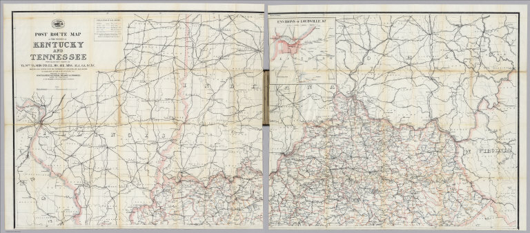
Post Route Map Of The States Of Kentucky And Tennessee With Adjacent Parts Of Va., West Va., Ohio, Ind., Ill., Mo., Ark., Miss., Ala., Ga., S.C., N.C. ... Published By Order Of Postmaster General Wilson S. Bissell Under The Direction Of A. Von Haake, Topographer P.O Dept. (seal) Post Office Department. United States Of America With Celerity, Certainty And Security. (inset) Environs Of Louisville, Ky.
List No
3145.002
Note
Northern 2 sheets only with most of Kentucky. Lacks lower 2 sheets. Folded into black cloth covers 17.5x10 stamped with "Sectional Map of Kentucky & Tennessee North" in gilt.
Author
[United States. Post Office Department, Von Haake, A.]
Full Title
(Covers to) Post route map of the states of California and Nevada showing post offices with the intermediate distances and mail routes in operation on the 1st of June, 1896. Published by order of Postmaster General William L. Wilson under the direction of A. von Haake, Topographer, P.O. Dept. (Washington, D.C., 1896)
List No
3356A
Note
Black cloth-covers. "Map of California, Nevada" stamped in gold. Paper labels affixed read "Lower part."
Author
[United States. Post Office Department, Von Haake, A.]
Full Title
Post route map of the states of California and Nevada showing post offices with the intermediate distances and mail routes in operation on the 1st of June, 1896. (Lower sheets) Published by order of Postmaster General William L. Wilson under the direction of A. von Haake, Topographer, P.O. Dept. (Washington, D.C., 1896)
List No
3356.001
Note
Composite of two col. sheets folded in cover. Comprise the southern half of the 4-sheet map. Shows drainage, counties, railroads, etc. Inset maps: (San Francisco Bay Area). Scale (ca. 1:450,000) -- (Los Angeles and vicinity). Scale (ca. 1:450,000). Includes lists of counties in California & Nevada.
Author
[United States. Post Office Department, Von Haake, A.]
Full Title
(Covers to) Post route map of the states of California and Nevada showing post offices with the intermediate distances and mail routes in operation on the 1st of June, 1896. Published by order of Postmaster General William L. Wilson under the direction of A. von Haake, Topographer, P.O. Dept. (Washington, D.C., 1896)
List No
3356B
Note
Black cloth-covers. "Map of California, Nevada" stamped in gold. Paper labels affixed read "Upper part."
Author
[United States. Post Office Department, Von Haake, A.]
Full Title
Post route map of the states of California and Nevada showing post offices with the intermediate distances and mail routes in operation on the 1st of June, 1896. (Upper sheets) Published by order of Postmaster General William L. Wilson under the direction of A. von Haake, Topographer, P.O. Dept. (Washington, D.C., 1896)
List No
3356.002
Note
Composite of two col. sheets folded in cover. Comprise the northern half of the 4-sheet map. Shows drainage, counties, railroads, etc.
Author
[United States. Post Office Department, Von Haake, A.]
Full Title
(Composite of) Post route map of the states of California and Nevada showing post offices with the intermediate distances and mail routes in operation on the 1st of June, 1896. Published by order of Postmaster General William L. Wilson under the direction of A. von Haake, Topographer, P.O. Dept. (Washington, D.C., 1896)
List No
3356.003
Note
Composite of four col. sheets folded in 2 covers. Shows drainage, counties, railroads, etc. Inset maps: (San Francisco Bay Area). Scale (ca. 1:450,000) -- (Los Angeles and vicinity). Scale (ca. 1:450,000). Includes lists of counties in California & Nevada.
Author
[United States. Post Office Department, Von Haake, A.]
Full Title
(Covers to) Post Route Map Of The State Of New Jersey Showing Post Offices With The Intermediate Distances On Mail Routes In Operation On The 1st Of March, 1904. Published By Order Of Postmaster General Henry C. Payne Under The Direction Of A. Von Haake, Topographer P.O. Dept. (seal) Post Office Department. United States Of America With Celerity, Certainty And Security.
List No
4089.001
Note
Excellent detail typical for the postal maps of this period. Since the railroads were the primary means of moving the mail, this shows many obscure local railroads not found on smaller scale maps. Folded into dark brown cloth covers 18x11 with "Map Of New Jersey" stamped in gilt.
Author
[United States. Post Office Department, Von Haake, A.]
Full Title
Post Route Map Of The State Of New Jersey Showing Post Offices With The Intermediate Distances On Mail Routes In Operation On The 1st Of March, 1904. Published By Order Of Postmaster General Henry C. Payne Under The Direction Of A. Von Haake, Topographer P.O. Dept. (seal) Post Office Department. United States Of America With Celerity, Certainty And Security.
List No
4089.002
Note
Excellent detail typical for the postal maps of this period. Since the railroads were the primary means of moving the mail, this shows many obscure local railroads not found on smaller scale maps. Folded into dark brown cloth covers 18x11 with "Map Of New Jersey" stamped in gilt.
Author
[United States. Post Office Department, Von Haake, A.]
Full Title
(Covers to) Post Route Map Of The States Of New Hampshire, Vermont Showing Post Offices With The Intermediate Distances On Mail Routes In Operation On The 1st Of March, 1912. Published By Order Of Postmaster General Frank H. Hitchcock Under The Direction Of A. von Haake, Topographer P.O. Dept. (seal) Post Office Department. United States Of America. "With Celerity, Certainty And Security".
List No
4164.001
Note
A very late example. With printed outline color; water printed in blue. Dissected and mounted on linen. Map folds into black paper end sheets 32.5x28 with a paper label reading "Post Route Map Of New Hampshire And Vermont."
Author
[United States. Post Office Department, Von Haake, A.]
Full Title
Post Route Map Of The States Of New Hampshire, Vermont Showing Post Offices With The Intermediate Distances On Mail Routes In Operation On The 1st Of March, 1912. Published By Order Of Postmaster General Frank H. Hitchcock Under The Direction Of A. von Haake, Topographer P.O. Dept. (seal) Post Office Department. United States Of America. "With Celerity, Certainty And Security".
List No
4164.002
Note
A very late example. With printed outline color; water printed in blue. Dissected and mounted on linen. Map folds into black paper end sheets 32.5x28 with a paper label reading "Post Route Map Of New Hampshire And Vermont."
Author
[United States. Post Office Department, Von Haake, A.]
Full Title
(Covers to) Post Route Map Of The Hawaiian Islands Showing Post Offices And Mail Routes In Operation On The 1st Of September, 1901. Published By Order Of Postmaster General Charles Emory Smith Under The Direction Of A. von Haake, Topographer P.O. Dept. (seal) Post Office Department. United States Of America. "With Celerity, Certainty And Security". (inset) Oahu Hawaiian Islands.
List No
4216A
Note
Similar to other postal maps, except that many of the routes are by sea from one island to another, and then around the coast to the various coastal towns. Only one red line leaves the island group, with the notation "From San Francisco, Cal., 1 round trip every 3 weeks." With a larger scale inset map of Oahu. Printed color. Map is dissected into 12 sections and folds into end sheets 33x31.5 of stiff black cloth with a paper label reading "Post Route Map Of Territory Of Hawaii."
Author
[United States. Post Office Department, Von Haake, A.]
Full Title
Post Route Map Of The Hawaiian Islands Showing Post Offices And Mail Routes In Operation On The 1st Of September, 1901. Published By Order Of Postmaster General Charles Emory Smith Under The Direction Of A. von Haake, Topographer P.O. Dept. (seal) Post Office Department. United States Of America. "With Celerity, Certainty And Security". (inset) Oahu Hawaiian Islands.
List No
4216.001
Note
Similar to other postal maps, except that many of the routes are by sea from one island to another, and then around the coast to the various coastal towns. Only one red line leaves the island group, with the notation "From San Francisco, Cal., 1 round trip every 3 weeks." With a larger scale inset map of Oahu. Printed color. Map is dissected into 12 sections and folds into end sheets 33x31.5 of stiff black cloth with a paper label reading "Post Route Map Of Territory Of Hawaii."
1-19 of 19
|