|
Author
[Aeronautical Chart and Information Center (U.S.), United States. National Aeronautics and Space Administration]
Full Title
(Covers to) Ranger IX Lunar chart. RLC 13 - 17. Compiled and published for National Aeronautics and Space Administration by Aeronautical Chart and Information Center, United States Air Force. Base 100. Base information May 1966. Lithographed by ACIC 6-66.
List No
13544.001
Note
Covers to Ranger 9, map of the moon surface RLC 13-17.
Author
[Aeronautical Chart and Information Center (U.S.), United States. National Aeronautics and Space Administration]
Full Title
Ranger IX Lunar chart: Ptolemaeus RLC 13
List No
13544.002
Note
2 maps on 1 sheet, both sides. Ptolemaeus Lunar 9 RLC 13.
Author
[Aeronautical Chart and Information Center (U.S.), United States. National Aeronautics and Space Administration]
Full Title
Ranger IX Lunar chart: Ptolemaeus RLC 13
List No
13544.003
Note
2 maps on 1 sheet, both sides. Ptolemaeus Lunar 9 RLC 13.
Author
[Aeronautical Chart and Information Center (U.S.), United States. National Aeronautics and Space Administration]
Full Title
Ranger IX Lunar chart: Alphonsus RLC 14
List No
13544.004
Note
2 maps on 1 sheet, both sides. Alphonsus Lunar 9 RLC 14.
Author
[Aeronautical Chart and Information Center (U.S.), United States. National Aeronautics and Space Administration]
Full Title
Ranger IX Lunar chart: Alphonsus RLC 14
List No
13544.005
Note
2 maps on 1 sheet, both sides. Alphonsus Lunar 9 RLC 14.
Author
[Aeronautical Chart and Information Center (U.S.), United States. National Aeronautics and Space Administration]
Full Title
Ranger IX Lunar chart: Alphonsus GA RLC 15
List No
13544.006
Note
2 maps on 1 sheet, both sides. Alphonsus GA Lunar 9 RLC 15.
Author
[Aeronautical Chart and Information Center (U.S.), United States. National Aeronautics and Space Administration]
Full Title
Ranger IX Lunar chart: Alphonsus GA RLC 15
List No
13544.007
Note
2 maps on 1 sheet, both sides. Alphonsus GA Lunar 9 RLC 15.
Author
[Aeronautical Chart and Information Center (U.S.), United States. National Aeronautics and Space Administration]
Full Title
Ranger IX Lunar chart: Alphonsus GP RLC 16
List No
13544.008
Note
2 maps on 1 sheet, both sides. Alphonsus GP Lunar 9 RLC 16.
Author
[Aeronautical Chart and Information Center (U.S.), United States. National Aeronautics and Space Administration]
Full Title
Ranger IX Lunar chart: Alphonsus GP RLC 16
List No
13544.009
Note
2 maps on 1 sheet, both sides. Alphonsus GP Lunar 9 RLC 16.
Author
[Aeronautical Chart and Information Center (U.S.), United States. National Aeronautics and Space Administration]
Full Title
Ranger IX Lunar chart. RLC 13 - 17. Compiled and published for National Aeronautics and Space Administration by Aeronautical Chart and Information Center, United States Air Force. Base 100. Base information May 1966. Lithographed by ACIC 6-66.
List No
13544.010
Note
2 maps on 1 sheet, both sides. Alphonsus GLH Lunar 9 RLC 17.
Author
U.S. Government Printing Office
Full Title
MAP OF THE CITY OF WASHINGTON STREET CLEANING DEPARTMENT
List No
15462.000
Author
Educational Services Division, Bureau of Naval Personnel, Navy Department
Full Title
NavWarMap No.6. We fight a Global War. (on verso) NavWarMap No.5. The South Pacific. Distributed by the Educational Services Division, Bureau of Naval Personnel, Navy Dept., Washington D.C.
List No
8760.006
Note
Shows significant wartime events as well as historic events. Continues: Continues: NavWarMap No. 1. The Mediterranean, and NavWarMap No. 2. The South China Sea Area. NavWarMap No. 3. The North Sea area. NavWarMap No. 4. The North Pacific area. Shows capital cities, pre-war boundaries, populated areas and population. air bases, naval bases, etc. Includes legend and notes.
Author
U.S. Department of Commerce, Office of Area Development, Business and Defense Services Administration
Full Title
Plate 21. Areas Susceptible of Reclamation in San Francisco Bay Area.
List No
9494.033
Note
Black and white.
Author
Educational Services Division, Bureau of Naval Personnel, Navy Department
Full Title
NavWarMap No. 1. The Mediterranean. Distributed by the Educational Services Division, Bureau of Naval Personnel, Navy Dept., Washington D.C.
List No
8760.001
Note
Shows significant wartime events and invasion routes.
Author
Educational Services Division, Bureau of Naval Personnel, Navy Department
Full Title
NavWarMap No. 2. The South China Sea Area. Distributed by the Educational Services Division, Bureau of Naval Personnel, Navy Dept., Washington D.C.
List No
8760.002
Note
Shows significant wartime events as well as historic events.
Author
[Harrison, Richard Edes, Army Orientation Course, Special Service Division Army Service Forces]
Full Title
Japan from Siberia. Newsmap. Monday, May 7, 1945. ... Vol. IV No. 3F. Prepared and Distributed by the Army Orientation Course. Special Service Division Army Service Forces, War Dept.,2E581 Pentagon Bldg., Washington D.C. U.S. Government Printing Office: 1944 - 591000.
List No
6771.001
Note
Birdseye view of shaded relief map with hypsometric elevations of Japan, Korea, and China from over Mongolia.
Author
[Harrison, Richard Edes, Army Orientation Course. Special Service Division Army Service Forces]
Full Title
Land of the Setting Sun. Prepared and Distributed by the Army Orientation Course. Morale Services Division, Army Service Forces, War Dept.,2E581 Pentagon Bldg., Washington D.C. U.S. Government Printing Office: 1943 - 538110. Eastern Front. Southwest New Britain. Netherlands Indies.
List No
12026.001
Author
[Harrison, Richard Edes, Army Orientation Course. Special Service Division Army Service Forces]
Full Title
The War Fronts. Newsmap. Monday, December 27, 1943. ... Vol. II No. 36. Prepared and Distributed by the Army Orientation Course. Morale Services Division, Army Service Forces, War Dept.,2E581 Pentagon Bldg., Washington D.C. U.S. Government Printing Office: 1943 - 538110.
List No
12026.002
Note
Shows extent of the Japanese Empire.
Author
[Aeronautical Chart and Information Center (U.S.), United States. National Aeronautics and Space Administration]
Full Title
Ranger VIII Lunar chart. Hypatia RLC 6
List No
13543.002
Note
2 maps on 1 sheet, both sides. Hypatia Lunar 8 RLC 6.
Author
[Aeronautical Chart and Information Center (U.S.), United States. National Aeronautics and Space Administration]
Full Title
Ranger VIII Lunar chart. Hypatia RLC 6
List No
13543.003
Note
2 maps on 1 sheet, both sides. Hypatia Lunar 8 RLC 6.
Author
[Aeronautical Chart and Information Center (U.S.), United States. National Aeronautics and Space Administration]
Full Title
Ranger VIII Lunar chart: Sabine RLC 7
List No
13543.004
Note
2 maps on 1 sheet, both sides. Sabine Lunar 8 RLC 7.
Author
[Aeronautical Chart and Information Center (U.S.), United States. National Aeronautics and Space Administration]
Full Title
Ranger VIII Lunar chart: Sabine RLC 7
List No
13543.005
Note
2 maps on 1 sheet, both sides. Sabine Lunar 8 RLC 7.
Author
[Aeronautical Chart and Information Center (U.S.), United States. National Aeronautics and Space Administration]
Full Title
Ranger VIII Lunar chart: Sabine D RLC 8
List No
13543.006
Note
2 maps on 1 sheet, both sides. Sabine D Lunar 8 RLC 8.
Author
[Aeronautical Chart and Information Center (U.S.), United States. National Aeronautics and Space Administration]
Full Title
Ranger VIII Lunar chart: Sabine D RLC 8
List No
13543.007
Note
2 maps on 1 sheet, both sides. Sabine D Lunar 8 RLC 8.
Author
[Aeronautical Chart and Information Center (U.S.), United States. National Aeronautics and Space Administration]
Full Title
Ranger VIII Lunar chart: Sabine DM RLC 9
List No
13543.008
Note
2 maps on 1 sheet, both sides. Sabine DM Lunar 8 RLC 9.
Author
[Aeronautical Chart and Information Center (U.S.), United States. National Aeronautics and Space Administration]
Full Title
Ranger VIII Lunar chart: Sabine DM RLC 9
List No
13543.009
Note
2 maps on 1 sheet, both sides. Sabine DM Lunar 8 RLC 9.
Author
[Aeronautical Chart and Information Center (U.S.), United States. National Aeronautics and Space Administration]
Full Title
Ranger VIII Lunar chart: Sabine EF RLC 10
List No
13543.010
Note
2 maps on 1 sheet, both sides. Sabine EF Lunar 8 RLC10..
Author
[Aeronautical Chart and Information Center (U.S.), United States. National Aeronautics and Space Administration]
Full Title
Ranger VIII Lunar chart: Sabine EF RLC 10
List No
13543.011
Note
2 maps on 1 sheet, both sides. Sabine EF Lunar 8 RLC10..
Author
[Aeronautical Chart and Information Center (U.S.), United States. National Aeronautics and Space Administration]
Full Title
Ranger VIII Lunar chart: Sabine EB RLC 11
List No
13543.012
Note
2 maps on 1 sheet, both sides. Sabine EB Lunar 8 RLC 11.
Author
[Aeronautical Chart and Information Center (U.S.), United States. National Aeronautics and Space Administration]
Full Title
Ranger VIII Lunar chart: Sabine EB RLC 11
List No
13543.013
Note
2 maps on 1 sheet, both sides. Sabine EB Lunar 8 RLC 11.
Author
[Aeronautical Chart and Information Center (U.S.), United States. National Aeronautics and Space Administration]
Full Title
Ranger VIII Lunar chart. RLC 6 - 12. Compiled and published for National Aeronautics and Space Administration by Aeronautical Chart and Information Center, United States Air Force. Base 100. Base information March 1966. Lithographed by ACIC 6-66.
List No
13543.014
Note
2 maps on 1 sheet, both sides. Sabine EBF Lunar 8 RLC 12.
Author
[Cowles, Calvin D., Davis, George B., Kirkley, JAW., Perry, Leslie J., United States. War Department]
Full Title
(Title Page to) Atlas to accompany the official records of the Union and Confederate armies. Published under the direction of the Hons. Redfield Proctor, Stephen B. Elkins and Daniel S. Lamont, secretaries of war, by Maj. George B. Davis, U.S. Army, Mr. Leslie J. Perry, civilian expert, Mr. Joseph W. Kirkley, civilian expert, Board of Publication. Compiled by Capt. Calvin D. Cowles, 23d U.S. Infantry. Washington: Government Printing Office, 1891-1895.
List No
1780A
Author
[Cowles, Calvin D., Davis, George B., Kirkley, JAW., Perry, Leslie J., United States. War Department]
Full Title
(Text Page to) Atlas to accompany the official records of the Union and Confederate armies. Published under the direction of the Hons. Redfield Proctor, Stephen B. Elkins and Daniel S. Lamont, secretaries of war, by Maj. George B. Davis, U.S. Army, Mr. Leslie J. Perry, civilian expert, Mr. Joseph W. Kirkley, civilian expert, Board of Publication. Compiled by Capt. Calvin D. Cowles, 23d U.S. Infantry. Washington: Government Printing Office, 1891-1895.
List No
1780B
Author
[Cowles, Calvin D., Davis, George B., Kirkley, JAW., Perry, Leslie J., United States. War Department]
Full Title
(Contents to) Atlas to accompany the official records of the Union and Confederate armies. Published under the direction of the Hons. Redfield Proctor, Stephen B. Elkins and Daniel S. Lamont, secretaries of war, by Maj. George B. Davis, U.S. Army, Mr. Leslie J. Perry, civilian expert, Mr. Joseph W. Kirkley, civilian expert, Board of Publication. Compiled by Capt. Calvin D. Cowles, 23d U.S. Infantry. Washington: Government Printing Office, 1891-1895.
List No
1780C
Author
[Cowles, Calvin D., Davis, George B., Kirkley, JAW., Perry, Leslie J., United States. War Department]
Full Title
(Contents to) Atlas to accompany the official records of the Union and Confederate armies. Published under the direction of the Hons. Redfield Proctor, Stephen B. Elkins and Daniel S. Lamont, secretaries of war, by Maj. George B. Davis, U.S. Army, Mr. Leslie J. Perry, civilian expert, Mr. Joseph W. Kirkley, civilian expert, Board of Publication. Compiled by Capt. Calvin D. Cowles, 23d U.S. Infantry. Washington: Government Printing Office, 1891-1895.
List No
1780D
Author
[Seymour, Truman, United States. War Department]
Full Title
Fort Moultrie as seen from Fort Sumter, February 13th, 1861. T. Seymour, Brevet Capt. U.S.A. Fort Johnson as seen from Fort Sumter ... Morris Island and Cumming's Point as seen from Fort Sumter ... Julius Bien & Co., Lith., N.Y. (1891-1895)
List No
1780.001
Note
Three sepia-tone views on 1 sheet. "Series I., vol. 1, page 171." With facsimile signature "Respectfully enclosed, Robert Anderson, Major U.S.A." Each view includes a key and location map.
Author
[Seymour, Truman, United States. War Department]
Full Title
Appearance of the batteries on Cumming's Point, March 4th, 1861. T. Seymour, Brevet Capt. U.S.A. ... Sketch of works east of Fort Johnson as seen from Fort Sumter, March 16th, 1861 ... Appearance of the works at Cumming's Point, February 19th, 1861 ... (with) Map of part of West Virginia, found among Lieut. Col. J.M. Heck's papers. (with) Sketch of fight at Rich Mountain, W. Va., July 12th, 1861 by Lieut. O.M. Poe, Top. Engrs. (with) Camp Garnett and vicinity, Rich Mt., Randolph Co., Va. (i.e. W. Va.) by the order of Lieut. Col. J.M. Heck ... 1861, Jed Hotchkiss, Top. Eng. (with) Sketch of Rich Mt. Battle-field, Randolph County, Va., July 11, 1861, Jed. Hotchkiss, Top. Eng. Julius Bien & Co., Lith., N.Y. (1891-1895)
List No
1780.002
Note
Three sepia-tone views on 1 sheet with 4 ancillary maps. With facsimile signature "Respectfully forwarded, Robert Anderson, Major U.S.A., Comdg." First view includes a key and location map.
Author
[Atkinson, W. G., United States. War Department, Whipple, Amiel W.]
Full Title
Plan of the battle-field at Bull Run, July 21st, 1861, to accompany the Report of Brig. Genl. Irvin McDowell, commanding, prepared by Capt. A.W. Whipple, Topl. Engrs, 1st Lieut. H.L. Abbot ... (and) 1st Lieut. H.S. Putnam ..., drawn by J.J. Young, civil engineer. Map of the battle-fields of Manassas and the surrounding region, showing the various actions of the 21st July, 1861, between the armies of the Confederate States and the United States, surveyed and drawn by W.G. Atkinson, acting 1st Lieut., Engineers. Julius Bien & Co., Lith., N.Y. (1891-1895)
List No
1780.003
Note
Two col. maps on 1 sheet. Relief shown by hachures. "Series I., vol. 2." With facsimile signature "Presented to the city of New Orleans by General G.T. Beauregard, Gen., comdg."
Author
[Arms, G.H., Gillmore, Quincy A., Grant, Ulysses S. (Ulysses Simpson), 1822-1885, United States. War Department]
Full Title
Map of the defenses of Charleston City and Harbor, showing also the works erected by the U.S. forces in 1863 and 1864. To accompany the Report of Major Genl. Q.A. Gillmore, U.S. Vols. (with) Plan of Belmont, from survey made by Capt. Arms, 2nd. Jan., 1862, by order of Brig. Gen. Trudeau, commanding heavy artillery. (with) The battle near Belmont, Missouri, Nov. 7th, 1861. Accompanying Report of Brig. Gen. U.S. Grant, U.S. Vols. Julius Bien & Co., Lith., N.Y. (1891-1895)
List No
1780.004
Note
Col. map with 2 ancillary maps. Depths shown by soundings. Includes "View off North Channel, Fort Sumter ... Febry. 18th, 1865."
Author
[Michler, Nathaniel, United States. War Department]
Full Title
Battle-field of Youngs Branch or Manassas Plains, battle fought July 21st, 1861. Tracing forwarded to the Chief of Engineers U.S.A. by Maj. N. Michler ... Map of the rebel fortifications at Columbus, Ky., surveyed under the direction of Brig. Genl. Geo. W. Cullum, Chief of Staff and engineers, Dept. of the Mississippi, 1862. (with) Map showing the position of the batteries used by the U.S. forces in the reduction of Fort Pulaski, April 10th & 11th, 1862. Accompanying Report of Brig. Gen. Quincy A. Gillmore, U.S. Vols. (with) Siege of Fort Pulaski, map of the mouth of Savannah River and adjacent islands ... (with) Action at Front Royal, Va., May 23d. 1862. Accompanying Report of Lieut. Col. Charles Parham, Twenty-ninth Pennsylvania Infantry. (with) Sketch of Fort Pickens, Florida, by Lt. Langdon ... 1861. (with) Reconnaissance of the battle-field at Bull Run, Va., fought July 21, 1861. Made on March 14, 1862 by Henry L. Abbot ... (with) Skirmishes near Bailey's Cross-roads, Va., August 28-30, 1861. Accompanying Report of Major S.G. Champlin ... (with) Accompanying Report of Brig. Gen. Louis Blenker, U.S. Vols., of information obtained from scouting parties, dated Hunter's Chapel, Va., Nov. 5, 1861. Julius Bien & Co., Lith., N.Y. (1891-1895)
List No
1780.005
Note
Two col. maps with 8 ancillary maps. Relief shown by contours, hachures and spot heights. Scales of main maps ca. 1:26,400 and 1:14,400.
Author
[Dorr, F. W., Rockwell, Cleveland, United States. War Department, Whiting, H. L.]
Full Title
Defenses of Washington. Map of the ground of occupation and defense of the Division of the U.S. Army in Virginia in command of Brig. Gen. Irvin McDowell. U.S. Coast Survey, A.D. Bache, Supdt. Topographical survey by the party in charge of H.L. Whiting, Asst., U.S.C.S. Field work executed during parts of June and July 1861, by F.W. Dorr and C. Rockwell U.S.C.S. (with) Sketch of Paducah, Ky. and vicinity by Captain John Rziha, 19th U.S. Infantry. (with) Sketch of the battle-field of Logan's Cross-roads, Ky. U.S. forces under the command of Brig. Gen. George H. Thomas. Forces of the enemy commanded by General G.B. Crittenden, Jan. 19, 1862. Drawn under the direction of Capt. Michler ... copied by A. Kilp. Sketch of the enemy's fortified position at and opposite Mill Springs, Ky., to which he retreated after his defeat at Logan's Cross-roads by the U.S. forces under Brig. Gen. George H. Thomas, Jan. 19, 1862 ... compiled ... by Edward Ruger ... drawn by A. Kilp ... Julius Bien & Co., Lith., N.Y. (1891-1895)
List No
1780.006
Note
Col. map with 2 ancillary maps. Relief shown by contours. Insets show relief by hachures.
Author
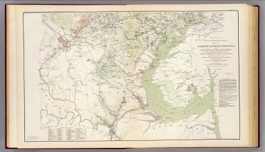
[Hesselbach, W., U.S. War Department, Topographical Engineers, United States. War Department, Young, J. J.]
Full Title
Surveys for military defenses. Map of northeastern Virginia and vicinity of Washington. Sheet 1. Compiled in Topographical Engineers Office at division headquarters of General Irvin McDowell, Arlington, January 1, 1862. Corrected from recent surveys and reconnaissances under direction of the Bureau of Topographical Engineers, August 1, 1862. Drawn by J.J. Young and W. Hesselbach. Julius Bien & Co., Lith., N.Y. (1891-1895)
List No
1780.007
Note
Col. map. Relief shown by hachures; depths by soundings. Includes "Geological profile of Loudoun County." "Accompanying the report of Maj. Gen. George B. McClellan, U.S. Army ... and Record of the McDowell Court of Inquiry ..."
Author
[Hesselbach, W., U.S. War Department, Topographical Engineers, United States. War Department, Young, J. J.]
Full Title
Surveys for military defenses. Map of northeastern Virginia and vicinity of Washington. Sheet 2. Compiled in Topographical Engineers Office at division headquarters of General Irvin McDowell, Arlington, January 1, 1862. Corrected from recent surveys and reconnaissances under direction of the Bureau of Topographical Engineers, August 1, 1862. Drawn by J.J. Young and W. Hesselbach. Julius Bien & Co., Lith., N.Y. (1891-1895)
List No
1780.008
Note
Col. map. Relief shown by hachures; depths by soundings. "Accompanying the report of Maj. Gen. George B. McClellan, U.S. Army ... and Record of the McDowell Court of Inquiry ..."
Author
[Margedant, William, Powell, W. Angelo, Raynolds, William F., United States. War Department]
Full Title
Military reconnaissance, vicinity of Gauley Bridge, Department of Western Virginia, Brig. Gen. W.S. Rosecrans, Commanding, by W.F. Raynolds, Capt. Top. Engrs., W. Margedant, Capt. O.V. and W. Angelo Powell, C. Engr. (with) Map of the battle-field of Carnifix Ferry, Gauley River, West Va. September 10th, 1861. United States forces commanded by Brig. Genl. W.S. Rosecrans. (with) Sketch of the country about Somerset, Ky. Julius Bien & Co., Lith., N.Y. (1891-1895)
List No
1780.009
Note
Col. map with 2 ancillary maps. Relief shown by hachures.
Author
United States. War Department
Full Title
Map showing the system of rebel fortifications on the Mississippi River at Island No. 10 and New Madrid, also the operations of the U.S. forces under General John Pope against these positions. (with) Route from Keetsville to Fayetteville, Ark. (with) Plan of the battle-field of Pea Ridge, Ark. Surveyed by H.A. Ulffers ... and A. Hoeppner ... (with) Route followed by the command of Maj. Joseph Conrad ... from near Bentonville, Ark. to Cassville, Mo., March 4-7, 1862. (with) Sketch A. Battle-field of Pea Ridge, Ark, March 7th, 1862 accompanying Report of Capt. Louis Hoffmann ... (with) Sketch B. Battle-field of Pea Ridge, Ark, March 8th, 1862 ... (with) Rebel position at Centreville, reconnaissance of March 14th, 1862 by M.D. McAlester ... (with) Battle at Leetown, March 7th, 1862. (with) Manassas Junction and vicinity surveyed by party of U.S. Coast Survey ... to act under orders of Lt. Col. J.N. Macomb ... Field work under direction of H.L. Whiting ... April 1862. (with) Sketch of battle-field at Shiloh near Pittsburg Landing, Tenn., April 6 and 7, 1862. Julius Bien & Co., Lith., N.Y. (1891-1895)
List No
1780.010
Note
Col. map with 9 ancillary maps. Relief in some ancillary maps shown by contours or hachures.
Author
United States. War Department
Full Title
Plan of Fort Henry and its outworks. Drawn under the direction of Lieut. Col. J.B. McPherson ... Sketch showing the relative positions of Fort Henry and Fort Donelson, also the roads connecting the two places. Drawn under the direction of Lieut. Col. J.B. McPherson ... by Charles Lambecker. Military map of the country between the Tennessee and Cumberland showing the operations of the 1st Div. from Feb. 4 to March 10, 1862. Sketch A. Plan of Fort Donelson and its outworks ... by Lieuts. Jenney and Kossak. Fort Donelson and the positions of the 1st Division during the siege of Feb. 12-16, 1862. Brig Genl. John A. McClernand commanding. (Fort Donelson) ... Julius Bien & Co., Lith., N.Y. (1891-1895)
List No
1780.011
Note
Seven col. maps. Relief shown by hachures.
Author
United States. War Department
Full Title
Engagement at Valverde, N.M., February 21, 1862. 12 o'cl. M. ... 4 o'cl. P.M. Accompanying report of Col. E.R.S. Canby ... Map of the field of Shiloh near Pittsburg Landing, Tenn. showing the positions of the U.S. forces under the command of Maj. Gen. U.S. Grant ... and Maj. Gen. D.C. Buell ... 6th and 7th of April, 1862. Surveyed under the direction of Col. Geo. C. Thom. (Shiloh Region). Operations near Fort Craig, N.M., February 1862. Sketch of the battle-field of Roanoke Island, February 8th, 1862. Drawn by Lt. Andrews ... Julius Bien & Co., Lith., N.Y. (1891-1895)
List No
1780.012
Note
Six col. maps. Relief shown by hachures.
Author
[Matz, Otto H., United States. War Department]
Full Title
Map of the country between Monterey, Tenn. and Corinth, Miss. showing the lines of intrenchments made and the routes followed by the U.S. forces under the command of Maj. Genl. Halleck, U.S. Army, in advance upon Corinth in May 1862. Surveyed under the direction of Col. Geo. Thom ... by lieuts. Fred Schraag and C.L. Spangenberg ... and drawn by Lieut. Otto H. Matz ... (with)Sketch of the battle field of Shiloh showing the dispositions of the troops under the command of Major General D.C. Buell on the 6th and 7th of April, 1862. Surveyed ... by Capt. N. Michler ... Assisted by John E. Weiss. (with) Advance upon Corinth, Miss., May 1862. Map accompanying report of Maj. Gen. W.T. Sherman, Wm. Kossak ... (with) Sketch of the position of the Army of the Potomac at Harrison's Landing, Va., 1862. Report of Maj. Gen. Geo. B. McClellan ... (with) Sketch of the positions of signal stations at Harrison's Landing, Va., 1862. Report of Maj. A.J. Myer ... (with) Sketch of the affair at Dranesville, Va., Dec. 20, 1861 between the government troops and the rebels. Accompanying report of Brig. Genl. E.O.C. Ord ... Julius Bien & Co., Lith., N.Y. (1891-1895)
List No
1780.013
Note
Col. map with 5 ancillary maps. Relief shown by hachures.
Author
[Abbot, Henry L., Comstock, Cyrus B., United States. War Department, Wagner, Orlando G.]
Full Title
Reconnaissance of secession works and plan of Siege of Yorktown. Made under orders of Gen'l. Barnard and Maj. Humphreys by Lieut. Abbot, Top. Engrs., Lieut. Comstock, Engrs., Lieut. Wagner, Top. Engrs. April and May 1862. Map no. 1. siege plan ... (with) Map of the battle-field of Shiloh, April 6th and 7th 1862. Accompanying report of Gen. G.T. Beauregard ... Topographical sketch of the line of operations of the Army of the Ohio, under the command of Major General D.C. Buell. Evacuation of Corinth by the enemy, May 30th, 1862 ... surveyed ... 1862 by N. Michler ... assisted by John E. Weiss (i.e. Weyss) ... Julius Bien & Co., Lith., N.Y. (1891-1895)
List No
1780.014
Note
Col. map with 2 ancillary maps. Relief shown by hachures.
Author
[Abbot, Henry L., Comstock, Cyrus B., United States. War Department]
Full Title
Reconnaissance of the secession works at Yorktown, Va. made by Lieut Abbot, Topl. Eng'rs. and at Gloucester, Va. made by Lieut. Comstock, Eng'rs., May 4, 1862. For Gen. J.G. Barnard ... (with) Sketch exhibiting the position of Yorktown with the approaches from reconnaissance and survey between the 5th and 10th of April 1862. By command of Maj. Gen. Geo. B. McClellan ... A.A. Humphreys ... Reconnaissance of Red Redoubt Group to right of Yorktown made by Lieut. N.G. Hall ... (with) The position of Yorktown with the approaches from reconnaissances and surveys made by command of Maj. Gen. Geo. B. McClellan ..., prepared under the direction of Maj. A.A. Humphreys ... April 21st 1862. Julius Bien & Co., Lith., N.Y. (1891-1895)
List No
1780.015
Note
Col. map with 3 ancillary maps. Relief shown by hachures.
|