|
Author
U.S. General Land Office
Full Title
Map Of The United States And Territories. To accompany annual report of Hon. Wm. A.J. Sparks Commissioner, General Land Office for fiscal year which ended June 30, 1885 ... N. Peters Photo-Lithographer, Washington, D.C. (inset) Alaska Territory.
List No
2353.002
Author
U.S. General Land Office
Full Title
(Covers to) Department of the Interior, General Land Office. Geographical and political atlas of the states and territories of the United States of America in which the Public Land Surveys are now in operation. S.S. Burdett, Commissioner. Washington City. 1876. Julius Bien, Photolith. & Print.
List No
11179.001
Note
Atlas in 20 plates,19 color maps. Including:1- New Mexico. 2-Idaho. 3-Kansas. 4-Washington. 5-Louisiana. 6-Dakota. 7-Nebraska. 8-Wyoming. 9- Arizona. 10-Utah. 11-Nevada. 12-Indian Territory.- 13-Oregon. 14-Montana. 15-Florida. 16-California in 2 shoots. 17-Minnesota. 18-Colorado. Maps showing land offices, townships subdivided, county seats, cities, towns, boundaries of land districts, railroad limits, military reservations, boundaries of counties, and Indian reservations. "Compiled from the official records of the General Land Office and other sources by C. Roeser, Principal Draughtsman G.L.O."
Author
U.S. General Land Office
Full Title
Department Of The Interior General Land Office J.A. Williamson, Commissioner. State of Colorado. 1879. Compiled from the official Records of the General Land Office and other sources by C. Roeser, Principal Draughtsman G.L.O. Photo lith & print by Julius Bien 16 & 18 Park Place N.Y.
List No
5447.000
Note
Printed color with Rocky Mountains shown by hachures. Military and Indian reservations highlighted by color.
Author
U.S. General Land Office
Full Title
(Covers to) Maps accompanying Report of the commissioner of the General Land Office.
List No
1070A
Author
U.S. General Land Office
Full Title
(Contents to) Maps accompanying Report of the commissioner of the General Land Office.
List No
1070B
Note
Table of contents has title: List Of Maps, Showing The progress of public surveys accompanying the Annual Report of the General Land Office, dated October 2, 1866 ... First large colored state maps issued by GLO. Maps mounted on linen and bound in folio with "General Land Office Report. Maps." stamped in gilt on the spine. No text, which was issued separately. Outline color. David Rumsey Collection copy lacks cover title.
Author
U.S. General Land Office
Full Title
State of Ohio. Department of Interior, General Land Office, October 2d 1866. Jo. S. Wilson, Commissioner. The Major & Knapp Eng. Mfg. & Lith. Co. 71 Broadway N.Y.
List No
1070.001
Note
Map in color by county. Boundaries for the Ohio Company purchase, the Virginia Military land, the Symmes's purchase, and the Connecticut Reserve are delineated. The explanations for the Land Office and the completed railroads have been added in pen.
Author
U.S. General Land Office
Full Title
A Diagram of the State of Indiana. Department of Interior, General Land Office, October 2d 1866. Jo. S. Wilson, Commissioner. The Major & Knapp Eng. Mfg. & Lith. Co. 71 Broadway N.Y.
List No
1070.002
Note
Map in color by county. The legend includes the Land Offices and the completed railroads. A state rich in coal deposits, it is estimated that the area of the coal fields is 7,700 square miles.
Author
U.S. General Land Office
Full Title
Map of the State of Illinois. Department of Interior, General Land Office, October 2d 1866. Jo. S. Wilson, Commissioner. Bowen & Co. lith. Phila.
List No
1070.003
Note
Map in outline color. Lead and copper regions are highlighted. It is noted that in one year more than 13,000,000 pounds of lead had been smelted.
Author
U.S. General Land Office
Full Title
Sketch of the Public Surveys in Michigan. To accompany the annual Report of the Commissioner, Genl. Land Office. Department of the Interior, General Land Office, October 2nd 1866. Jo. S. Wilson, Commissioner. Bowen & Co. lith. Philada. (with) inset map of Isle Royale.
List No
1070.004
Note
Large map showing the Land Office; railroads; wagon roads; and the copper, iron and silver regions. In outline color.
Author
U.S. General Land Office
Full Title
Sketch of the Public Surveys in the State of Wisconsin. Department of the Interior, General Land Office, October 2nd 1866. Jo. S. Wilson, Commissioner. The Major & Knapp Eng. Mfg. & Lith. Co. 71 Broadway, N.Y.
List No
1070.005
Note
Map in outline color. The "6 miles Limits" are shown in pink.
Author
U.S. General Land Office
Full Title
Sketch of the Public Surveys in the State of Minnesota. Department of the Interior, General Land Office, October 2nd 1866. Jo. S. Wilson, Commissioner. The Major & Knapp Eng. Mfg. & Lith. Co. 71 Broadway, N.Y. Joseph Gorlinski Draughtsman, G.L.O.
List No
1070.006
Note
In outline color. The "6 mile limits" are shown in pink. The seat of the Surveyor General's Office is shown in green.
Author
U.S. General Land Office
Full Title
Diagram of the Public Surveys in Iowa. Department of the Interior, General Land Office, October 2nd 1866. Jo. S. Wilson, Commissioner. No. 7.
List No
1070.007
Note
In outline color. Iron, lead and coal regions are shown.
Author
U.S. General Land Office
Full Title
Dakota Territory. Department of the Interior, General Land Office, October 2nd 1866. Jo. S. Wilson, Commissioner. The Major & Knapp Eng. Mfg. & Lith. Co. 71 Broadway, N.Y.
List No
1070.008
Note
The territory is largely unsurveyed. Surveying has only been completed in a few townships right along the Missouri River. The map shows the treaty line of July 23, 1851.
Author
U.S. General Land Office
Full Title
State of Missouri. Department of the Interior, General Land Office, October 2nd 1866. Jo. S. Wilson, Commissioner. No. 9. Bowen & Co. Lith. Phila.
List No
1070.009
Note
In outline color. Topographical information is included in the note area.
Author
U.S. General Land Office
Full Title
Map of Arkansas. Department of the Interior, General Land Office, October 2nd 1866. Jo. S. Wilson, Commissioner. No. 10.
List No
1070.010
Note
Map in outline color. Coal regions are shown in gray.
Author
U.S. General Land Office
Full Title
Map of Louisiana. Department of the Interior, General Land Office, October 2nd 1866. Jo. S. Wilson, Commissioner. No. 11. Joseph Gorlinski, Draughtsman, G.L.O.
List No
1070.011
Note
Map in outline color.
Author
U.S. General Land Office
Full Title
Sketch of the Public Surveys in the State of Mississippi. Department of the Interior, General Land Office, October 2nd 1866. Jo. S. Wilson, Commissioner. No. 12.
List No
1070.012
Note
In outline color.
Author
U.S. General Land Office
Full Title
State of Alabama. Department of the Interior, General Land Office, October 2nd 1866. Jo. S. Wilson, Commissioner. No. 13. Bowen & Co. lith. Philada.
List No
1070.013
Note
In outline color. It is noted that the whole central region in underlaid with iron ore. Also found are coal and lead ore.
Author
U.S. General Land Office
Full Title
Map of the State of Florida, Showing the Progress of the Surveys Accompanying Annual Report of the Commissioner Genl. Land Office. Department of the Interior, General Land Office, October 2nd 1866. Jo. S. Wilson, Commissioner. Lith. of J. Bien, 24 Vesey Street, N.Y. Sen Ex. Doc. No. 1, 2d. Sess: 36 Cong.
List No
1070.014
Note
Map in outline color.
Author
U.S. General Land Office
Full Title
(12) Map Showing the progress of the Public surveys in Kansas and Nebraska. 1866. Surveyor General's Office, Leavenworth, Kansas, August 25th, 1866. Department of the Interior, General Land Office, October 2nd 1866. Jo. S. Wilson, Commissioner. No. 15. Bowen & Co. lith. Philada.
List No
1070.015
Note
In outline color with the land offices in pink and the surveyor general's office in green. The legend includes coal, lead, platina, marble, and salt lands.
Author
U.S. General Land Office
Full Title
Map of Public Surveys in Colorado Territory. to accompany report of the Surr. Genl. 1866. Department of the Interior, General Land Office, October 2nd 1866. Jo. S. Wilson, Commissioner. The Major & Knapp Engraving, Manuf. & Lithographic Company, 71 Broadway, New York.
List No
1070.016
Note
Map in outline color. The developed gold regions are highlighted in gold. It is noted that the dotted lines are for proposed surveys. Many of the townships have yet to be sectionalized.
Author
U.S. General Land Office
Full Title
Sketch of Public Surveys in New Mexico & Arizona to accompany the Annual Report of the Commissioner of the General Land Office for 1866. Department of the Interior, General Land Office, October 2nd 1866. Jo. S. Wilson, Commissioner. The Major & Knapp Eng. Mfg. & Lith. Co., 71 Broadway, New York. Ho. Reps. Ex. Doc. No. 1, 37th Cong. 3d. Sess.
List No
1070.017
Note
Map in outline color. Gold, silver, and copper mines are prominently shown.
Author
U.S. General Land Office
Full Title
Map of the Territory of Utah. To accompany the annual Report of the Commissioner of the General Land Office. Department of the Interior, General Land Office, October 2nd 1866. Jo. S. Wilson, Commissioner. No. 18. The Major & Knapp Engraving, Manuf. & Lithographic Company, 71 Broadway, New York.
List No
1070.018
Note
In outline color. Indian reservations are outlined in gray.
Author
U.S. General Land Office
Full Title
Map of the State of Nevada. To accompany the Annual Report of the Commr. Genl. Land Office 1866. Department of the Interior, General Land Office, October 2nd 1866. Jo. S. Wilson, Commissioner. The Major & Knapp Eng., Mfg. & Lith. Co. 71 Broadway, New York.
List No
1070.019
Note
In outline color. Silver, gold and copper mines shown.
Author
U.S. General Land Office
Full Title
Map of the Public Surveys in California and Nevada to accompany Report of the Commissioner of the General Land Office 1866. Department of the Interior, General Land Office, October 2nd 1866. Jo. S. Wilson, Commissioner. Lith. of J. Bien, 24 Vesey Street, N.Y. House R. Ex. Doc. No. 1. 38th Cong. 1st. Sess.
List No
1070.020
Note
Map in outline color. The following items are shown: asphaltum wells, salt ponds, oil springs, and numerous types of mines including gold, silver, quick silver, copper, tin and lead.
Author
U.S. General Land Office
Full Title
Oregon. Surveyor General's Office, Eugene City, July 20, 1866. E.L. Applegate. Surv. Gen. of Oregon. Department of the Interior, General Land Office, October 2nd 1866. Jo. S. Wilson, Commissioner. No. 21. The Major & Knapp Eng., Mfg. & Lith. Co. 71 Broadway, New York.
List No
1070.021
Note
Map in outline color.
Author
U.S. General Land Office
Full Title
Map of Public Surveys in the Territory of Washington. To Accompany Report of Surveyor General. 1865. Department of the Interior, General Land Office, October 2nd 1866. Jo. S. Wilson, Commissioner. Surveyor General's Office, Olympia, W.T., July 15th, 1865. E. Giddings. Act. Survr. Genl. W.T. No. 22. Bowen & Co. lith. Philada.
List No
1070.022
Note
In outline color.
Author
U.S. General Land Office
Full Title
Map of the United States and Territories. Shewing the extent of the Public Surveys and other details Constructed From the Plats and official sources of the General Land Office Under the direction of the Hon. Jos. S. Wilson, Commissioner, by Theodore Franks, Draughtsman. 1866. Department of the Interior, General Land Office, October 2nd 1866. Jo. S. Wilson, Commissioner. Engraved by D. McClelland, Washn. D.C.
List No
1070.023
Note
Map in outline color with an extensive legend showing mining activities.
Author
U.S. General Land Office
Full Title
(Covers to) Centennial Map Of The United States and Territories Showing the Extent of Public Surveys, Indian and Military Reservations...& Other Details.
List No
1071.001
Note
Custom made red cloth covered boards assembled as a case with gilt title on front cover reading, "Centennial Map of the United States and Territories - 1878."
Author
U.S. General Land Office
Full Title
Index to the Centennial Map Of The United States and Territories.
List No
1071.002
Note
Shows the geographic footprint for each of the sixteen maps.
Author
U.S. General Land Office
Full Title
(Map 1 - Florida) (portion of title block shown reads:) of the United States and Territories showing the extent of Public Surveys, Indian and Military Reservations, Land Grants R.R., Rail Roads, Canals, Cities, Towns & other Details. Compiled from the Official Surveys of the General Land Office, and other authentic Sources, under the Direction of the Committee of Public Lands, House of Representatives, by W.L. Woods, Clerk of the Committee ... C. Roeser, Chief Draughtsman. Revised and Corrected to 1878. Copyright 1878 by W.L. Woods.
List No
1071.003
Note
One of the series of adjacent sixteen maps. Mounted on linen.
Author
U.S. General Land Office
Full Title
(Map 2 - North Carolina, South Carolina, Georgia) (portion of title block shown reads:) 1876 Centennial Map.
List No
1071.004
Note
One of the series of adjacent sixteen maps. Mounted on linen. Relief shown in hachures.
Author
U.S. General Land Office
Full Title
(Map 3 - Virginia, West Virginia, Ohio, Pennsylvania, Maryland, Delaware, New Jersey, New York, Rhode Island, Massachusetts, Connecticut).
List No
1071.005
Note
One of the series of adjacent sixteen maps. Mounted on linen. Relief shown in hachures.
Author
U.S. General Land Office
Full Title
(Map 4 - Maine, New Hampshire, Vermont, New York).
List No
1071.006
Note
One of the series of adjacent sixteen maps. Mounted on linen. Relief shown in hachures.
Author
U.S. General Land Office
Full Title
(Map 5 - Texas, Lousiana).
List No
1071.007
Note
One of the series of adjacent sixteen maps. Mounted on linen.
Author
U.S. General Land Office
Full Title
(Map 6 - Indian Territory, Arkansas, Mississippi, Alabama, Tennessee, Missouri, Kentucky, Louisiana).
List No
1071.008
Note
One of the series of adjacent sixteen maps. Mounted on linen. Relief shown in hachures.
Author
U.S. General Land Office
Full Title
(Map 7 - Iowa, Indiana, Illinois, Michigan, Wisconsin, Minnesota, Missouri).
List No
1071.009
Note
One of the series of adjacent sixteen maps. Mounted on linen.
Author
U.S. General Land Office
Full Title
(Map 8 - Minnesota, Wisconsin, Michigan).
List No
1071.010
Note
One of the series of adjacent sixteen maps. Mounted on linen.
Author
U.S. General Land Office
Full Title
(Map 9 - Texas).
List No
1071.011
Note
One of the series of adjacent sixteen maps. Mounted on linen. Relief shown in hachures.
Author
U.S. General Land Office
Full Title
(Map 10 - Texas, New Mexico, Indian Territories, Utah).
List No
1071.012
Note
One of the series of adjacent sixteen maps. Mounted on linen. Relief shown in hachures.
Author
U.S. General Land Office
Full Title
(Map 11 - Wyoming, Nebraska, Colorado, Kansas, South Dakota).
List No
1071.013
Note
One of the series of adjacent sixteen maps. Mounted on linen. Relief shown in hachures.
Author
U.S. General Land Office
Full Title
(Map 12 - Montana, North Dakota).
List No
1071.014
Note
One of the series of adjacent sixteen maps. Mounted on linen. Relief shown in hachures.
Author
U.S. General Land Office
Full Title
(Map 13 - Alaska).
List No
1071.015
Note
One of the series of adjacent sixteen maps. Mounted on linen. Relief shown in hachures.
Author
U.S. General Land Office
Full Title
(Map 14 - California, Arizona, Nevada).
List No
1071.016
Note
One of the series of adjacent sixteen maps. Mounted on linen. Relief shown in hachures.
Author
U.S. General Land Office
Full Title
(Map 15 - California, Nevada, Utah, Idaho).
List No
1071.017
Note
One of the series of adjacent sixteen maps. Mounted on linen. Relief shown in hachures.
Author
U.S. General Land Office
Full Title
(Map 16 - Washington, Oregon, Montana, Idaho).
List No
1071.018
Note
One of the series of adjacent sixteen maps. Mounted on linen. Relief shown in hachures.
Author
U.S. General Land Office
Full Title
(Composite of) Centennial Map Of The United States and Territories Showing the Extent of Public Surveys, Indian and Military Reservations...& Other Details.
List No
1071.019
Note
Composite map of all 16 sheets.
Author
U.S. General Land Office
Full Title
Map of the Public Surveys in California ; to Accompany Report of Surveyor Genl., 1854. P.S. Duval & Co's Steam Lith. Press. Phila. Surveyor General's Office, San Francisco, Calif., Sept. 28th, 1854, Approved John C. Hays, U.S. Sur. Genl. Cal.
List No
1073.001
Note
Eleven issues from the Annual Report, (1854,55,56,57,58,59,60,61,62, 63,64). Without color. Scale 16 miles to an inch. Relief shown by hachures. In upper left corner: Sen. Ex. No. 1. 2nd Sess. 33d Cong. Shows townships, and lands surveyed and proposed to be surveyed. Includes Explanation.
Author
U.S. General Land Office
Full Title
Map of the Public Surveys in California ; to Accompany Report of Surveyor Genl., 1855. Lith. by A. Hoen & Co. Balto. Surveyor General's Office, San Francisco, Calif., Sept. 30th, 1855, Approved John C. Hays, U.S. Sur. Genl. Cal.
List No
1073.002
Note
Eleven issues from the Annual Report, (1854,55,56,57,58,59,60,61,62, 63,64). Without color. Scale 18 miles to an inch. Relief shown by hachures. In upper right corner: Sen. Ex. Doc. No. 1. , 34th. Cong. 1st. Sess. Shows townships, and lands surveyed and proposed to be surveyed. Includes Explanation. (From: Report of the Commissioner of the General Land Office).
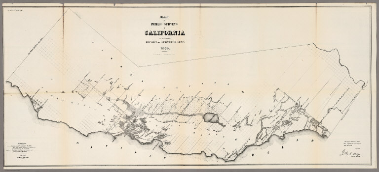
Author
U.S. General Land Office
Full Title
Map of the Public Surveys in California ; to Accompany Report of Surveyor Genl., 1856. Surveyor General's Office, San Francisco, Calif., Sept. 30th, 1856, Approved, U.S. Sur. Genl. Cal.
List No
1073.003
Note
Eleven issues from the Annual Report, (1854,55,56,57,58,59,60,61,62, 63,64). Without color. Scale 18 miles to an inch. Relief shown by hachures. In upper right corner: Senete Exe. Doc. No. 5, 34th Congress, 3rd Session. Shows Description of private Grants, townships, and lands surveyed and proposed to be surveyed. Includes Explanation. (From: Report of the Commissioner of the General Land Office).
|