|
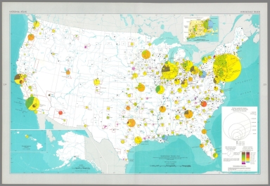
Author
[Geological Survey (U.S.), U.S. Census Bureau]
Full Title
Wholesale trade : 1963 / adapted from U. S. Bureau of the Census, Retail trade in the United States: 1963, GE-50, no. 20, Washington, U. S. Govt. Print Off., 1963, map 1:5,000,000.
List No
14359.170
Note
Business map representing the United States, featuring the geographic locations of wholesale trade, showing total sales in dollars, as well as the percentage of change in sales from 1958 to 1963. Map also shows political boundaries, bodies of water, drainage, coastlines and islands. Includes a legend, as well as a bar scale and scale statement. Presented with Albers Equal Area Projection. With three inset maps: Massachusetts, Connecticut & Rhode Island -- Principal islands of Hawaii -- Alaska. Colored lithograph. Map is 43 x 66 cm, on double sheet 49 x 71 cm. Appears in Special subject maps section, subsection Economic : Business.
Author
[Geological Survey (U.S.), U.S. Census Bureau]
Full Title
Selected population characteristics / compiled from U. S. Bureau of the Census, Census of population: 1960, v. 1, pt. A, Washington, U. S. Govt. Print Off., 1961 -- Population density : 1960.
List No
14359.180
Note
Chart and statistical map representing the United States, featuring the geographic density of population, including for major cities, as of 1960. Map also shows political boundaries, bodies of water, coastlines and islands. Includes a legend, as well as a bar scale and scale statement. Presented with Albers Equal Area Projection. With two inset maps: Principal islands of Hawaii -- Alaska. Chart shows populations for cities, including the change in population from 1950 to 1960. Colored lithograph. Map and chart are each 20 x 31 cm, on sheet 49 x 35 cm. Map and chart appear in Special subject maps section, subsection Socio-Cultural.
Author
[Geological Survey (U.S.), U.S. Census Bureau]
Full Title
American Indian population : 1960 / adapted from U. S. Bureau of the Census, American Indians in the United States: 1960, GE-50, no. 14, Washington, U. S. Govt. Print Off., 1967, map 1:5,000,000.
List No
14359.193
Note
Statistical map representing the United States, featuring the geographic density of the indigenous population, as of 1960. Map also shows political boundaries, bodies of water, drainage, coastlines and islands. Includes a legend, as well as a bar scale and scale statement. Presented with Albers Equal Area Projection. With two inset maps: Principal islands of Hawaii -- Alaska. Colored lithograph. Map is 43 x 66 cm, on double sheet 49 x 71 cm. Appears in Special subject maps section, subsection Socio-Cultural.
Author
[Geological Survey (U.S.), U.S. Census Bureau]
Full Title
Median family income : 1959 / compiled from U. S. Bureau of the Census, County and city data book: 1962, Washington, U. S. Govt. Print Off., 1962, table 2, item 22; Census of population: 1960, PC(S1)-48, Washington, U. S. Govt. Print Off., 1965, table 3.
List No
14359.196
Note
Statistical map representing the United States, featuring the geographic density of population according to the median family income in 1959. Map also shows political boundaries, bodies of water, drainage, coastlines and islands. Includes a legend, as well as a bar scale and scale statement. Presented with Albers Equal Area Projection. With two inset maps: Principal islands of Hawaii -- Alaska. Colored lithograph. Map is 43 x 66 cm, on double sheet 49 x 71 cm. Appears in Special subject maps section, subsection Socio-Cultural.
Author
[Geological Survey (U.S.), U.S. Census Bureau, National Geographic Society (U.S.)]
Full Title
United States exports and imports of commodities : 1967 / compiled by U. S. Bureau of the Census: U. S. exports, 1967, FT 455, annual, table 3; U. S. general imports, 1967, FT 455, annual, table 3, Washington, U. S. Govt. Print. Off., 1968. Base map by National Geographic Society, The world, 1:63,360,000; rev. by U. S. Geol. Survey, 1968.
List No
14359.251
Note
World map featuring United States exports and imports of commodities in 1967. Shows streams of commerce between the United States and other nations, national borders, bodies of water, drainage, glaciers, coastlines and islands. Includes latitudinal and longitudinal lines, as well as a legend, bar scale, scale statement and explanatory notes. With three inset charts: Total exports, by commodity group -- Total imports, by commodity group -- Exports and imports by commodity group. Presented with Van der Grinten Projection. Colored lithograph. Map is 42 x 65 cm, on double sheet 49 x 71 cm. Appears in Special subject maps section, subsection World.
Author
[Geological Survey (U.S.), U.S. Census Bureau]
Full Title
Logging camps : 1963 -- Sawmills : 1963 / compiled from U. S. Bureau of the Census, Census of manufactures, 1963, Spec. Rept. MC63(S)-3.3, Washington, U. S. Govt. Print. Off., 1966.
List No
14359.113
Note
Two economic maps representing the United States, featuring forestry, as of 1963. Maps show the number of logging camps and sawmills in 1963, political boundaries, bodies of water, coastlines and islands. Maps include legends, as well as bar scales and scale statements. Presented with Albers Equal Area Projection. With two inset maps within each map: Principal islands of Hawaii -- Alaska. Colored lithograph. Maps are each 20 x 31 cm, on sheet 49 x 35 cm. Maps appear in Special subject maps section, subsection Economic : Fishing and forestry.
Author
[Geological Survey (U.S.), U.S. Census Bureau, United States. Conservation Needs Inventory Committee, United States. Department of Agriculture]
Full Title
Land in farms : 1964 -- Land in farms as a percent of total land area : 1964 -- Cropland : 1964 / compiled by U. S. Bureau of the Census, Census of agriculture: 1964, v. I, Washington, U. S. Govt. Print Off., 1967, county table 1 -- Cropland as a percent of total land area : 1964 -- Grazing and pastureland : 1959 -- Grazing and pastureland as a percent of total land area : 1959 / compiled from information provided by the Conservation Needs Inventory Committee, U. S. Dept. of Agriculture, 1967 -- Forest and woodland : 1959 -- Forest and woodland as a percent of total land area : 1959.
List No
14359.116
Note
Eight economic maps representing the United States, featuring the major uses of land - such as cropland, grazing and pastureland, and forest and woodland - as of 1964. Maps show the absolute figures for land use, as well as the percentage out of the total land area. Maps also show political boundaries, bodies of water, coastlines and islands. Maps include legends, as well as bar scales and scale statements. Presented with Albers Equal Area Projection. With two inset maps within each map: Principal islands of Hawaii -- Alaska. Colored lithograph. Together, maps are 42 x 31 cm, on sheet 49 x 35 cm. Accompanying descriptive text on page 157. Maps appear in Special subject maps section, subsection Economic : Agriculture.
Author
[Geological Survey (U.S.), U.S. Census Bureau]
Full Title
Full owners and part owners : 1964 / compiled from U. S. Bureau of the Census, Census of agriculture: 1964, v. I, Washington, U. S. Govt. Print Off., 1967, county table 4 and State table 3 -- Managers and tenants : 1964.
List No
14359.117
Note
Two economic maps representing the United States, featuring ownership of land, as of 1964. Maps show full and part ownership of farms, managers and tenants of farms, as well as political boundaries, bodies of water, coastlines and islands. Maps include legends, as well as bar scales and scale statements. Presented with Albers Equal Area Projection. With two inset maps within each map: Principal islands of Hawaii -- Alaska. Colored lithograph. Maps are each 20 x 31 cm, on sheet 49 x 35 cm. Maps appear in Special subject maps section, subsection Economic : Agriculture.
Author
[Geological Survey (U.S.), U.S. Census Bureau]
Full Title
Total farms : 1964 / compiled from U. S. Bureau of the Census, Census of agriculture: 1964, v. I, Washington, U. S. Govt. Print Off., 1967, county table 1 and State table 2 -- Farms of less than 50 acres : 1964 -- Farms of 50-179 acres : 1964 -- Farms of 180-259 acres : 1964 -- Farms of 260-499 acres : 1964 -- Farms of 500-999 acres : 1964 -- Farms of 260-499 acres : 1964 -- Farms of 1,000 acres or more : 1964 -- General farms : 1964 -- Livestock farms : 1964 -- Cash-grain farms : 1964 -- Dairy and poultry farms : 1964 -- Tobacco, cotton and other field crop farms : 1964 -- Vegetable and fruit and nut farms : 1964.
List No
14359.118
Note
Thirteen economic maps representing the United States, featuring farm sizes and types - such as livestock, field crops, fruits and vegetables - as of 1964. Maps show political boundaries, bodies of water, drainage, coastlines and islands. Maps include legends, as well as explanatory notes and scale statements (scales differ). With two inset maps within each map: Principal islands of Hawaii -- Alaska. Colored lithograph. Together, maps are 42 x 65 cm, on double sheet 49 x 71 cm. Maps appear in Special subject maps section, subsection Economic : Agriculture.
Author
[Geological Survey (U.S.), U.S. Census Bureau]
Full Title
Hired workers : 1964 / compiled from U. S. Bureau of the Census, Census of agriculture: 1964, v. I, Washington, U. S. Govt. Print Off., 1967, county table 8; Statistical Reporting Service, Farm labor, Washington, U. S. Dept. of Agric. March 1965, p. 4 and 6 -- Expenditures for hired labor on farms : 1964 / compiled from U. S. Bureau of the Census, Census of agriculture: 1964, v. I, Washington, U. S. Govt. Print Off., 1967, county table 9.
List No
14359.119
Note
Two economic maps representing the United States, featuring farm laborers and costs of labor, as of 1964. Maps show hired works as a percentage of total farm labor, as well as the expenditure for hired labor. Maps also show political boundaries, bodies of water, coastlines and islands. Maps include legends, as well as bar scales and scale statements. Presented with Albers Equal Area Projection. With two inset maps within each map: Principal islands of Hawaii -- Alaska. Colored lithograph. Maps are each 20 x 31 cm, on sheet 49 x 35 cm. Maps appear in Special subject maps section, subsection Economic : Agriculture.
Author
[Geological Survey (U.S.), U.S. Census Bureau]
Full Title
Total commercial farms : 1964 -- Class I farms : 1964 -- Class II farms : 1964 -- Class III farms : 1964 -- Class IV farms : 1964 -- Class V farms : 1964 -- Class VI farms : 1964 -- Part-time and part-retirement farms : 1964 / all maps compiled from U. S. Bureau of the Census, Census of agriculture: 1964, v. I, Washington, U. S. Govt. Print Off., 1967, county table 6 and State table 17.
List No
14359.120
Note
Eight economic maps representing the United States, featuring economic classes of farms, as of 1964. Maps show the total number of commercial farms, as well as Class I-VI farms, and part-time and part-retirement farms. Maps also show political boundaries, bodies of water, coastlines and islands. Maps include legends, as well as bar scales and scale statements. Presented with Albers Equal Area Projection. With two inset maps within each map: Principal islands of Hawaii -- Alaska. Colored lithograph. Together, maps are 42 x 31 cm, on sheet 49 x 35 cm. Maps appear in Special subject maps section, subsection Economic : Agriculture.
Author
[Geological Survey (U.S.), U.S. Census Bureau]
Full Title
Average value of land and buildings per farm : 1964 / compiled from U. S. Bureau of the Census, Census of agriculture: 1964, v. I, Washington, U. S. Govt. Print Off., 1967, county table 1 -- Expenditures for petroleum products : 1964 -- Expenditures for machine hire, custom and contract work : 1964 / compiled from U. S. Bureau of the Census, Census of agriculture: 1964, v. I, Washington, U. S. Govt. Print Off., 1967, county table 9 -- Expenditures for feed : 1964 -- Expenditures for fertilizers : 1964.
List No
14359.121
Note
Five economic maps representing the United States, featuring values of farms and their expenditures, as of 1964. Maps show values of both land and buildings, as well as expenditures for petroleum products, labor, machinery, feed and fertilizers. Maps also show political boundaries, bodies of water, coastlines and islands. Maps include legends, as well as bar scales and scale statements (scales differ). Presented with Albers Equal Area Projection. With two inset maps within each map: Principal islands of Hawaii -- Alaska. Colored lithograph. Together, maps are 42 x 31 cm, on sheet 49 x 35 cm. Maps appear in Special subject maps section, subsection Economic : Agriculture.
Author
[Geological Survey (U.S.), U.S. Census Bureau]
Full Title
Average commercially fertilized : 1964 / compiled from U. S. Bureau of the Census, Census of agriculture: 1964, v. I, Washington, U. S. Govt. Print Off., 1967, county table 9 and State table 1 -- Farm ponds : 1964 / compiled from U. S. Bureau of the Census, Census of agriculture: 1964, v. I, county table 1; v. II, chap. 9, table 14, Washington, U. S. Govt. Print Off., 1967 -- Acreage limed : 1964 / compiled from U. S. Bureau of the Census, Census of agriculture: 1964, v. I, Washington, U. S. Govt. Print Off., 1967, county table 9 and State table 1 -- Cropland farmed on the contour : 1964 / compiled from U. S. Bureau of the Census, Census of agriculture: 1964, v. I, county table 1; v. II, chap. 9, table 14, Washington, U. S. Govt. Print Off., 1967 -- Land in strip crops : 1964 / compiled from U. S. Bureau of the Census, Census of agriculture: 1964, v. I, county table 1; v. II, chap. 9, table 14, Washington, U. S. Govt. Print Off., 1967.
List No
14359.122
Note
Five economic maps representing the United States, featuring the use of farmland, as of 1964. Maps show acreage commercially fertilized, limed, farmed on the contour and in strip crops, as well as the percentage of farms with ponds. Maps also show political boundaries, bodies of water, coastlines and islands. Maps include legends, as well as bar scales and scale statements (scales differ). Presented with Albers Equal Area Projection. With two inset maps within each map: Principal islands of Hawaii -- Alaska. Colored lithograph. Together, maps are 42 x 31 cm, on sheet 49 x 35 cm. Maps appear in Special subject maps section, subsection Economic : Agriculture.
Author
[Geological Survey (U.S.), U.S. Census Bureau]
Full Title
Irrigated land in farms : 1964 / compiled from U. S. Bureau of the Census, Census of agriculture: 1964, v. I, Washington, U. S. Govt. Print Off., 1967, county tables 1 and 2, and State table 1 -- Agricultural land in drainage enterprises : 1959 / compiled from U. S. Bureau of the Census, Census of agriculture: 1959, v. IV, Washington, U. S. Govt. Print Off., 1961, county table 1.
List No
14359.123
Note
Two economic maps representing the United States, featuring water practices on farms, as of 1964. Maps show irrigation and drainage enterprises on agricultural land. Maps also show political boundaries, bodies of water, coastlines and islands. Maps include legends, as well as bar scales and scale statements. Presented with Albers Equal Area Projection. With two inset maps within each map: Principal islands of Hawaii -- Alaska. Colored lithograph. Maps are each 20 x 31 cm, on sheet 49 x 35 cm. Maps appear in Special subject maps section, subsection Economic : Agriculture.
Author
[Geological Survey (U.S.), U.S. Census Bureau, United States. Department of Agriculture. Statistical Reporting Service]
Full Title
Field crops sold : 1964 -- Livestock and products sold : 1964 -- Dairy products sold : 1964 -- Poultry and products sold : 1964 / the four maps above compiled from U. S. Bureau of the Census, Census of agriculture: 1964, v. I, Washington, U. S. Govt. Print Off., 1967, county table 6, and State table 17 -- Wheat harvested : 1964 / compiled from U. S. Bureau of the Census, Census of agriculture: 1964, v. I, county table 13, and v. II, chap. 4, table 16, Washington, U. S. Govt. Print Off., 1967; Statistical Reporting Service, Field crops, Stat. Bull. 384, Washington U. S. Dept. of Agriculture, 1966, table 1. (with) Barley harvested : 1964 / compiled by Census of agriculture: 1964, v. I, county table 13, v. II, chap. 4, table 25; Field crops, Stat. Bull. 384, tables 11 & 46 -- Cotton harvested : 1964 / compiled by Census of agriculture: 1964, v. I, county table 13; Field crops, Stat. Bull. 384, table 45 -- Sorghums and oats harvested : 1964 / compiled by Census of agriculture: 1964, v. I, county table 13, v. II, chap. 4, table 24; Field crops, Stat. Bull. 384, tables 10 & 46 -- Soybeans harvested : 1964 / compiled by Census of agriculture: 1964, v. I, county table 13, v. II, chap. 4, table 45; Field crops, Stat. Bull. 384, table 23 -- Corn harvested : 1964 / compiled by Census of agriculture: 1964, v. I, county table 13, and v. II, chap. 4, table 12, Washington, U. S. Govt. Print Off., 1967; Statistical Reporting Service, Field crops, Stat. Bull. 384, Washington U. S. Dept. of Agriculture, 1966, table 9.
List No
14359.125
Note
Ten economic maps representing the United States, featuring crops sold and harvested - such as wheat, barley, cotton and corn - as of 1964. Maps also show political boundaries, bodies of water, coastlines and islands. Maps include legends, as well as bar scales and scale statements (scales differ). Presented with Albers Equal Area Projection. With two inset maps within each map: Principal islands of Hawaii -- Alaska. Colored lithograph. Together, maps are 42 x 31 cm, on sheet 49 x 35 cm. Maps appear in Special subject maps section, subsection Economic : Agriculture.
Author
[Geological Survey (U.S.), U.S. Census Bureau, United States. Department of Agriculture. Statistical Reporting Service]
Full Title
Hay cut : 1964 / compiled by U. S. Bureau of the Census, Census of agriculture: 1964, v. I, county table 13, and v. II, chap. 4, table 35, Washington, U. S. Govt. Print Off., 1967 -- Peanuts, flax, and rice harvested : 1964 / compiled from Census of agriculture: 1964, v. I, county table 13 -- Tobacco, sugar cane, and sugar beets harvested : 1964 / compiled from Census of agriculture: 1964, v. I, county table 13 -- Irish and sweet potatoes harvested : 1964 / compiled from Census of agriculture: 1964, v. I, county table 13; Potatoes and sweet potatoes, Stat. Bull. 409, tables 16-20 & 27 -- Dry field and seed beans harvested : 1964 / compiled from Census of agriculture: 1964, v. I, county table 13; Field and seed crops, Stat. Bull. 404, table 14.
List No
14359.126
Note
Five economic maps representing the United States, featuring crops harvested - such as hay, rice and tobacco - as of 1964. Maps also show political boundaries, bodies of water, coastlines and islands. Maps include legends, as well as bar scales and scale statements (scales differ). Presented with Albers Equal Area Projection. With two inset maps within each map: Principal islands of Hawaii -- Alaska. Colored lithograph. Together, maps are 42 x 31 cm, on sheet 49 x 35 cm. Maps appear in Special subject maps section, subsection Economic : Agriculture.
Author
[Geological Survey (U.S.), U.S. Census Bureau, United States. Department of Agriculture. Statistical Reporting Service]
Full Title
Cattle and calves on farms : 1964 / compiled by U. S. Bureau of the Census, Census of agriculture: 1964, v. I, Washington, U. S. Govt. Print Off., 1967, county table 10 -- Milk cows on farms : 1964 / compiled by U. S. Bureau of the Census, Census of agriculture: 1964, v. I, Washington, U. S. Govt. Print Off., 1967, county table 10 -- Cattle and calves sold : 1964 / compiled by U. S. Bureau of the Census, Census of agriculture: 1964, v. I, Washington, U. S. Govt. Print Off., 1967, county table 11 -- Sheep and lambs on farms : 1964 / compiled by U. S. Bureau of the Census, Census of agriculture: 1964, v. I, Washington, U. S. Govt. Print Off., 1967, county table 10 -- Wool shorn : 1964 / compiled by U. S. Bureau of the Census, Census of agriculture: 1964, v. I, Washington, U. S. Govt. Print Off., 1967, county table 11.
List No
14359.127
Note
Five economic maps representing the United States, featuring livestock on farms - such as cattle and calves, sheep and lambs, as well as wool shorn - as of 1964. Maps also show political boundaries, bodies of water, coastlines and islands. Maps include legends, as well as bar scales and scale statements (scales differ). Presented with Albers Equal Area Projection. With two inset maps within each map: Principal islands of Hawaii -- Alaska. Colored lithograph. Together, maps are 42 x 31 cm, on sheet 49 x 35 cm. Maps appear in Special subject maps section, subsection Economic : Agriculture.
Author
[Geological Survey (U.S.), U.S. Census Bureau, United States. Department of Agriculture. Statistical Reporting Service]
Full Title
Value of vegetables, fruits and nuts, and forest and horticultural specialties sold : 1964 / compiled from U. S. Bureau of the Census, Census of agriculture: 1964, v. I, Washington, U. S. Govt. Print Off., 1967, county table 6 and State table 17 -- Tomatoes harvested : 1964 / compiled from U. S. Bureau of the Census, Census of agriculture: 1964, v. I, Washington, U. S. Govt. Print Off., 1967, county table 13; Statistical Reporting Service, Vegetables for processing, Stat. Bull. 411, table 12, Vegetables for fresh market, Stat. Bull. 412, table 27; Washington, U. S. Dept. of Agriculture, 1967 -- Sweet corn harvested : 1964 / compiled from U. S. Bureau of the Census, Census of agriculture: 1964, v. I, Washington, U. S. Govt. Print Off., 1967, county table 13; Statistical Reporting Service, Vegetables for processing, Stat. Bull. 411, table 8, Vegetables for fresh market, Stat. Bull. 412, table 15; Washington, U. S. Dept. of Agriculture, 1967 -- Snap peas harvested : 1964 / compiled from U. S. Bureau of the Census, Census of agriculture: 1964, v. I, Washington, U. S. Govt. Print Off., 1967, county table 13; Statistical Reporting Service, Vegetables for processing, Stat. Bull. 411, table 5, Vegetables for fresh market, Stat. Bull. 412, table 7; Washington, U. S. Dept. of Agriculture, 1967 -- Green peas harvested : 1964 / compiled from U. S. Bureau of the Census, Census of agriculture: 1964, v. I, Washington, U. S. Govt. Print Off., 1967, county table 13; Statistical Reporting Service, Vegetables for processing, Stat. Bull. 411, table 10, Vegetables for fresh market, Stat. Bull. 412, table 23; Washington, U. S. Dept. of Agriculture, 1967 -- Watermelons harvested : 1964 / compiled from U. S. Bureau of the Census, Census of agriculture: 1964, v. I, Washington, U. S. Govt. Print Off., 1967, county table 13; Statistical Reporting Service, Vegetables for fresh market, Stat. Bull. 412, table 30; Washington, U. S. Dept. of Agriculture, 1967 -- Strawberries harvested : 1964 / compiled from U. S. Bureau of the Census, Census of agriculture: 1964, v. I, Washington, U. S. Govt. Print Off., 1967, county table 13; Statistical Reporting Service, Vegetables for fresh market, Stat. Bull. 412, table 33; Washington, U. S. Dept. of Agriculture, 1967 -- English walnuts and pecan trees : 1964 / compiled from U. S. Bureau of the Census, Census of agriculture: 1964, v. I, Washington, U. S. Govt. Print Off., 1967, county table 13; Statistical Reporting Service, Tree nuts, Stat. Bull. 381, tables 7 and 8; Washington, U. S. Dept. of Agriculture, 1967 -- Orange trees : 1964 / compiled from U. S. Bureau of the Census, Census of agriculture: 1964, v. I, Washington, U. S. Govt. Print Off., 1967, county table 13; Statistical Reporting Service, Citrus fruits, Stat. Bull. 380, tables 49, 51, 57, 69, 74, and 75; Washington, U. S. Dept. of Agriculture, 1967 -- Apple and peach trees : 1964 / compiled from U. S. Bureau of the Census, Census of agriculture: 1964, v. I, Washington, U. S. Govt. Print Off., 1967, county table 13; Statistical Reporting Service, Fruits - noncitrus, Stat. Bull. 407, tables 2-6 and 34-38; Washington, U. S. Dept. of Agriculture, 1967 -- Grapefruit and lemon trees : 1964 / compiled from U. S. Bureau of the Census, Census of agriculture: 1964, v. I, Washington, U. S. Govt. Print Off., 1967, county table 13; Statistical Reporting Service, Citrus fruits, Stat. Bull. 380, tables 49, 51, 57, 69, 74, and 75; Washington, U. S. Dept. of Agriculture, 1967 -- Grape vines : 1964 / compiled from U. S. Bureau of the Census, Census of agriculture: 1964, v. I, Washington, U. S. Govt. Print Off., 1967, county table 13; Statistical Reporting Service, Fruits - noncitrus, Stat. Bull. 407, tables 24-28; Washington, U. S. Dept. of Agriculture, 1967 -- Plum and prune trees : 1964 / compiled from U. S. Bureau of the Census, Census of agriculture: 1964, v. I, Washington, U. S. Govt. Print Off., 1967, county table 13; Statistical Reporting Service, Fruits - noncitrus, Stat. Bull. 407, tables 48, 50, and 51; Washington, U. S. Dept. of Agriculture, 1967.
List No
14359.128
Note
Thirteen economic maps representing the United States, featuring crops harvested - such as strawberries and tomatoes, as well as the number and value of food-producing trees, such as walnut, orange and apple - as of 1964. Maps show political boundaries, bodies of water, drainage, coastlines and islands. Maps include legends, as well as explanatory notes and scale statements (scales differ). With two inset maps within each map: Principal islands of Hawaii -- Alaska. Colored lithograph. Together, maps are 42 x 65 cm, on double sheet 49 x 71 cm. Maps appear in Special subject maps section, subsection Economic : Agriculture.
Author
[Geological Survey (U.S.), U.S. Census Bureau, United States. Department of Agriculture. Statistical Reporting Service]
Full Title
Hogs and pigs on farms : 1964 / compiled by U. S. Bureau of the Census, Census of agriculture: 1964, v. I, Washington, U. S. Govt. Print Off., 1967, county table 10 -- Chickens on farms : 1964 / compiled by U. S. Bureau of the Census, Census of agriculture: 1964, v. I, Washington, U. S. Govt. Print Off., 1967, county table 10 -- Chickens sold : 1964 / compiled by U. S. Bureau of the Census, Census of agriculture: 1964, v. I, Washington, U. S. Govt. Print Off., 1967, county table 12 -- Chicken eggs sold : 1964 / compiled by U. S. Bureau of the Census, Census of agriculture: 1964, v. I, Washington, U. S. Govt. Print Off., 1967, county table 12 -- Turkeys raised : 1964 / compiled by U. S. Bureau of the Census, Census of agriculture: 1964, v. I, Washington, U. S. Govt. Print Off., 1967, county table 12.
List No
14359.129
Note
Five economic maps representing the United States, featuring livestock on farms - such as hogs, pigs and chickens, as well as eggs sold - as of 1964. Maps also show political boundaries, bodies of water, coastlines and islands. Maps include legends, as well as bar scales and scale statements (scales differ). Presented with Albers Equal Area Projection. With two inset maps within each map: Principal islands of Hawaii -- Alaska. Colored lithograph. Together, maps are 42 x 31 cm, on sheet 49 x 35 cm. Maps appear in Special subject maps section, subsection Economic : Agriculture.
Author
[Geological Survey (U.S.), U.S. Census Bureau, United States. Bureau of Mines]
Full Title
Mining capital expenditures and employment : 1963 / compiled from U. S. Bureau of the Census, Census of mineral industries: 1963, MIC63(2)-1 to 49, Washington, U. S. Govt. Print Off., 1967, table 2A, and U. S. Bureau of Mines, Minerals yearbook: 1964, v. III, U. S. Govt. Print Off., table 1, p. 51 -- Value added by mining : 1963 / compiled from U. S. Bureau of the Census, Census of mineral industries: 1963, MIC63(2)-1 to 49, Washington, U. S. Govt. Print Off., 1967, tables 2A and 3.
List No
14359.141
Note
Two mineral maps representing the United States, featuring the geographic locations of mining capital expenditures and employment, as well as the monetary value of mining, as of 1963. Maps also show political boundaries, bodies of water, coastlines and islands. Maps include legends, as well as bar scales and scale statements. Presented with Albers Equal Area Projection. With two inset maps within each map: Principal islands of Hawaii -- Alaska. Colored lithograph. Maps are each 20 x 31 cm, on sheet 49 x 35 cm. Accompanying descriptive text on page 177. Maps appear in Special subject maps section, subsection Economic : Mineral and energy resources.
Author
[Geological Survey (U.S.), U.S. Census Bureau]
Full Title
Employees in manufacturing : 1963 / compiled from U. S. Bureau of the Census, County and city data book: 1967, Washington, U. S. Govt. Print Off., 1967, table 2, item 64 -- Percent change in manufacturing employment : 1958-1963 / compiled from U. S. Bureau of the Census, County and city data book: 1967, Washington, U. S. Govt. Print Off., 1967, table 2, items 64 and 71.
List No
14359.142
Note
Two manufacturing maps representing the United States, featuring the geographic locations of manufacturing employment, as well as the change in employment from 1958 to 1963. Maps also show political boundaries, bodies of water, coastlines and islands. Maps include legends, as well as bar scales and scale statements. Presented with Albers Equal Area Projection. With two inset maps within each map: Principal islands of Hawaii -- Alaska. Colored lithograph. Maps are each 20 x 31 cm, on sheet 49 x 35 cm. Maps appear in Special subject maps section, subsection Economic : Manufacturing.
Author
[Geological Survey (U.S.), U.S. Census Bureau]
Full Title
Manufacturing employment in standard metropolitan statistical areas : 1963 / compiled from U. S. Bureau of the Census, Census of manufacturers: 1963, MC63(3)-1 through MC63(3)-51, Washington, U. S. Govt. Print Off., 1964, tables 6 and 7, and misc. census reports and directories of manufacturers.
List No
14359.143
Note
Manufacturing map representing the United States, featuring the geographic locations of manufacturing employment in metropolitan areas, as of 1963. Shows employees in the manufacturing of products such as textiles, lumber and paper, as well as political boundaries, bodies of water, drainage, coastlines and islands. Includes a legend, as well as a bar scale and scale statement. Presented with Albers Equal Area Projection. With four inset maps: Massachusetts, Connecticut & Rhode Island -- Middle Atlantic -- Principal islands of Hawaii -- Alaska. Colored lithograph. Map is 43 x 66 cm, on double sheet 49 x 71 cm. Appears in Special subject maps section, subsection Economic : Manufacturing.
Author
[Geological Survey (U.S.), U.S. Census Bureau]
Full Title
Establishments in manufacturing : 1963 / compiled from U. S. Bureau of the Census, County and city data book: 1967, Washington, U. S. Govt. Print Off., 1967, table 2, item 73 -- Value added in manufacturing : 1963 / compiled from U. S. Bureau of the Census, County and city data book: 1967, Washington, U. S. Govt. Print Off., 1967, table 2, item 69.
List No
14359.144
Note
Two manufacturing maps representing the United States, featuring the geographic locations of manufacturing establishments, as well as the value of manufacturing, as of 1963. Maps also show political boundaries, bodies of water, coastlines and islands. Maps include legends, as well as bar scales and scale statements. Presented with Albers Equal Area Projection. With two inset maps within each map: Principal islands of Hawaii -- Alaska. Colored lithograph. Maps are each 20 x 31 cm, on sheet 49 x 35 cm. Maps appear in Special subject maps section, subsection Economic : Manufacturing.
Author
[Geological Survey (U.S.), U.S. Census Bureau]
Full Title
Employment : 1963 (SIC 20) / compiled from U. S. Bureau of the Census, Census of manufacturers: 1963, Washington, U. S. Govt. Print Off., 1966; and various State and national directories of manufacturers -- Value added : 1963 (SIC 20) / compiled from U. S. Bureau of the Census, Census of manufacturers: 1963, Washington, U. S. Govt. Print Off., 1966.
List No
14359.145
Note
Two manufacturing maps representing the United States, featuring the geographic locations of manufacturing employment, as well as the value of manufacturing in 1963 for "(SIC 20)" i.e., food and kindred products. Maps also show political boundaries, bodies of water, coastlines and islands. Maps include legends, as well as bar scales and scale statements. Presented with Albers Equal Area Projection. With two inset maps within each map: Principal islands of Hawaii -- Alaska. Colored lithograph. Maps are each 20 x 31 cm, on sheet 49 x 35 cm. Maps appear in Special subject maps section, subsection Economic : Manufacturing.
Author
[Geological Survey (U.S.), U.S. Census Bureau]
Full Title
Employment : 1963 (SIC 21) / compiled from U. S. Bureau of the Census, Census of manufacturers: 1963, Washington, U. S. Govt. Print Off., 1966; and various State and national directories of manufacturers -- Value added : 1963 (SIC 21) / compiled from U. S. Bureau of the Census, Census of manufacturers: 1963, Washington, U. S. Govt. Print Off., 1966.
List No
14359.146
Note
Two manufacturing maps representing the United States, featuring the geographic locations of manufacturing employment, as well as the value of manufacturing in 1963 for "(SIC 21)" i.e., tobacco. Maps also show political boundaries, bodies of water, coastlines and islands. Maps include legends, as well as bar scales and scale statements. Presented with Albers Equal Area Projection. With two inset maps within each map: Principal islands of Hawaii -- Alaska. Colored lithograph. Maps are each 20 x 31 cm, on sheet 49 x 35 cm. Maps appear in Special subject maps section, subsection Economic : Manufacturing.
Author
[Geological Survey (U.S.), U.S. Census Bureau]
Full Title
Employment : 1963 (SIC 22) / compiled from U. S. Bureau of the Census, Census of manufacturers: 1963, Washington, U. S. Govt. Print Off., 1966; and various State and national directories of manufacturers -- Value added : 1963 (SIC 22) / compiled from U. S. Bureau of the Census, Census of manufacturers: 1963, Washington, U. S. Govt. Print Off., 1966.
List No
14359.147
Note
Two manufacturing maps representing the United States, featuring the geographic locations of manufacturing employment, as well as the value of manufacturing in 1963 for "(SIC 22)" i.e., textiles. Maps also show political boundaries, bodies of water, coastlines and islands. Maps include legends, as well as bar scales and scale statements. Presented with Albers Equal Area Projection. With two inset maps within each map: Principal islands of Hawaii -- Alaska. Colored lithograph. Maps are each 20 x 31 cm, on sheet 49 x 35 cm. Maps appear in Special subject maps section, subsection Economic : Manufacturing.
Author
[Geological Survey (U.S.), U.S. Census Bureau]
Full Title
Employment : 1963 (SIC 23) / compiled from U. S. Bureau of the Census, Census of manufacturers: 1963, Washington, U. S. Govt. Print Off., 1966; and various State and national directories of manufacturers -- Value added : 1963 (SIC 23) / compiled from U. S. Bureau of the Census, Census of manufacturers: 1963, Washington, U. S. Govt. Print Off., 1966.
List No
14359.148
Note
Two manufacturing maps representing the United States, featuring the geographic locations of manufacturing employment, as well as the value of manufacturing in 1963 for "(SIC 23)" i.e., apparel and other finished products made from fabric and other similar materials. Maps also show political boundaries, bodies of water, coastlines and islands. Maps include legends, as well as bar scales and scale statements. Presented with Albers Equal Area Projection. With two inset maps within each map: Principal islands of Hawaii -- Alaska. Colored lithograph. Maps are each 20 x 31 cm, on sheet 49 x 35 cm. Maps appear in Special subject maps section, subsection Economic : Manufacturing.
Author
[Geological Survey (U.S.), U.S. Census Bureau]
Full Title
Employment : 1963 (SIC 24) / compiled from U. S. Bureau of the Census, Census of manufacturers: 1963, Washington, U. S. Govt. Print Off., 1966; and various State and national directories of manufacturers -- Value added : 1963 (SIC 24) / compiled from U. S. Bureau of the Census, Census of manufacturers: 1963, Washington, U. S. Govt. Print Off., 1966.
List No
14359.149
Note
Two manufacturing maps representing the United States, featuring the geographic locations of manufacturing employment, as well as the value of manufacturing in 1963 for "(SIC 24)" i.e., lumber and wood products, except furniture. Maps also show political boundaries, bodies of water, coastlines and islands. Maps include legends, as well as bar scales and scale statements. Presented with Albers Equal Area Projection. With two inset maps within each map: Principal islands of Hawaii -- Alaska. Colored lithograph. Maps are each 20 x 31 cm, on sheet 49 x 35 cm. Maps appear in Special subject maps section, subsection Economic : Manufacturing.
Author
[Geological Survey (U.S.), U.S. Census Bureau]
Full Title
Employment : 1963 (SIC 25) / compiled from U. S. Bureau of the Census, Census of manufacturers: 1963, Washington, U. S. Govt. Print Off., 1966; and various State and national directories of manufacturers -- Value added : 1963 (SIC 25) / compiled from U. S. Bureau of the Census, Census of manufacturers: 1963, Washington, U. S. Govt. Print Off., 1966.
List No
14359.150
Note
Two manufacturing maps representing the United States, featuring the geographic locations of manufacturing employment, as well as the value of manufacturing in 1963 for "(SIC 25)" i.e., furniture and fixtures. Maps also show political boundaries, bodies of water, coastlines and islands. Maps include legends, as well as bar scales and scale statements. Presented with Albers Equal Area Projection. With two inset maps within each map: Principal islands of Hawaii -- Alaska. Colored lithograph. Maps are each 20 x 31 cm, on sheet 49 x 35 cm. Maps appear in Special subject maps section, subsection Economic : Manufacturing.
Author
[Geological Survey (U.S.), U.S. Census Bureau]
Full Title
Employment : 1963 (SIC 26) / compiled from U. S. Bureau of the Census, Census of manufacturers: 1963, Washington, U. S. Govt. Print Off., 1966; and various State and national directories of manufacturers -- Value added : 1963 (SIC 26) / compiled from U. S. Bureau of the Census, Census of manufacturers: 1963, Washington, U. S. Govt. Print Off., 1966.
List No
14359.151
Note
Two manufacturing maps representing the United States, featuring the geographic locations of manufacturing employment, as well as the value of manufacturing in 1963 for "(SIC 26)" i.e., paper and allied products. Maps also show political boundaries, bodies of water, coastlines and islands. Maps include legends, as well as bar scales and scale statements. Presented with Albers Equal Area Projection. With two inset maps within each map: Principal islands of Hawaii -- Alaska. Colored lithograph. Maps are each 20 x 31 cm, on sheet 49 x 35 cm. Maps appear in Special subject maps section, subsection Economic : Manufacturing.
Author
[Geological Survey (U.S.), U.S. Census Bureau]
Full Title
Employment : 1963 (SIC 27) / compiled from U. S. Bureau of the Census, Census of manufacturers: 1963, Washington, U. S. Govt. Print Off., 1966; and various State and national directories of manufacturers -- Value added : 1963 (SIC 27) / compiled from U. S. Bureau of the Census, Census of manufacturers: 1963, Washington, U. S. Govt. Print Off., 1966.
List No
14359.152
Note
Two manufacturing maps representing the United States, featuring the geographic locations of manufacturing employment, as well as the value of manufacturing in 1963 for "(SIC 27)" i.e., printing, publishing and allied industries. Maps also show political boundaries, bodies of water, coastlines and islands. Maps include legends, as well as bar scales and scale statements. Presented with Albers Equal Area Projection. With two inset maps within each map: Principal islands of Hawaii -- Alaska. Colored lithograph. Maps are each 20 x 31 cm, on sheet 49 x 35 cm. Maps appear in Special subject maps section, subsection Economic : Manufacturing.
Author
[Geological Survey (U.S.), U.S. Census Bureau]
Full Title
Employment : 1963 (SIC 28) / compiled from U. S. Bureau of the Census, Census of manufacturers: 1963, Washington, U. S. Govt. Print Off., 1966; and various State and national directories of manufacturers -- Value added : 1963 (SIC 28) / compiled from U. S. Bureau of the Census, Census of manufacturers: 1963, Washington, U. S. Govt. Print Off., 1966.
List No
14359.153
Note
Two manufacturing maps representing the United States, featuring the geographic locations of manufacturing employment, as well as the value of manufacturing in 1963 for "(SIC 28)" i.e., chemicals and allied products. Maps also show political boundaries, bodies of water, coastlines and islands. Maps include legends, as well as bar scales and scale statements. Presented with Albers Equal Area Projection. With two inset maps within each map: Principal islands of Hawaii -- Alaska. Colored lithograph. Maps are each 20 x 31 cm, on sheet 49 x 35 cm. Maps appear in Special subject maps section, subsection Economic : Manufacturing.
Author
[Geological Survey (U.S.), U.S. Census Bureau]
Full Title
Employment : 1963 (SIC 29) / compiled from U. S. Bureau of the Census, Census of manufacturers: 1963, Washington, U. S. Govt. Print Off., 1966; and various State and national directories of manufacturers -- Value added : 1963 (SIC 29) / compiled from U. S. Bureau of the Census, Census of manufacturers: 1963, Washington, U. S. Govt. Print Off., 1966.
List No
14359.154
Note
Two manufacturing maps representing the United States, featuring the geographic locations of manufacturing employment, as well as the value of manufacturing in 1963 for "(SIC 29)" i.e., petroleum, refining and related industries. Maps also show political boundaries, bodies of water, coastlines and islands. Maps include legends, as well as bar scales and scale statements. Presented with Albers Equal Area Projection. With two inset maps within each map: Principal islands of Hawaii -- Alaska. Colored lithograph. Maps are each 20 x 31 cm, on sheet 49 x 35 cm. Maps appear in Special subject maps section, subsection Economic : Manufacturing.
Author
[Geological Survey (U.S.), U.S. Census Bureau]
Full Title
Employment : 1963 (SIC 30) / compiled from U. S. Bureau of the Census, Census of manufacturers: 1963, Washington, U. S. Govt. Print Off., 1966; and various State and national directories of manufacturers -- Value added : 1963 (SIC 30) / compiled from U. S. Bureau of the Census, Census of manufacturers: 1963, Washington, U. S. Govt. Print Off., 1966.
List No
14359.155
Note
Two manufacturing maps representing the United States, featuring the geographic locations of manufacturing employment, as well as the value of manufacturing in 1963 for "(SIC 30)" i.e., rubber and miscellaneous plastic products. Maps also show political boundaries, bodies of water, coastlines and islands. Maps include legends, as well as bar scales and scale statements. Presented with Albers Equal Area Projection. With two inset maps within each map: Principal islands of Hawaii -- Alaska. Colored lithograph. Maps are each 20 x 31 cm, on sheet 49 x 35 cm. Maps appear in Special subject maps section, subsection Economic : Manufacturing.
Author
[Geological Survey (U.S.), U.S. Census Bureau]
Full Title
Employment : 1963 (SIC 31) / compiled from U. S. Bureau of the Census, Census of manufacturers: 1963, Washington, U. S. Govt. Print Off., 1966; and various State and national directories of manufacturers -- Value added : 1963 (SIC 31) / compiled from U. S. Bureau of the Census, Census of manufacturers: 1963, Washington, U. S. Govt. Print Off., 1966.
List No
14359.156
Note
Two manufacturing maps representing the United States, featuring the geographic locations of manufacturing employment, as well as the value of manufacturing in 1963 for "(SIC 31)" i.e., leather and leather products. Maps also show political boundaries, bodies of water, coastlines and islands. Maps include legends, as well as bar scales and scale statements. Presented with Albers Equal Area Projection. With two inset maps within each map: Principal islands of Hawaii -- Alaska. Colored lithograph. Maps are each 20 x 31 cm, on sheet 49 x 35 cm. Maps appear in Special subject maps section, subsection Economic : Manufacturing.
Author
[Geological Survey (U.S.), U.S. Census Bureau]
Full Title
Employment : 1963 (SIC 32) / compiled from U. S. Bureau of the Census, Census of manufacturers: 1963, Washington, U. S. Govt. Print Off., 1966; and various State and national directories of manufacturers -- Value added : 1963 (SIC 32) / compiled from U. S. Bureau of the Census, Census of manufacturers: 1963, Washington, U. S. Govt. Print Off., 1966.
List No
14359.157
Note
Two manufacturing maps representing the United States, featuring the geographic locations of manufacturing employment, as well as the value of manufacturing in 1963 for "(SIC 32)" i.e., stone, clay and glass products. Maps also show political boundaries, bodies of water, coastlines and islands. Maps include legends, as well as bar scales and scale statements. Presented with Albers Equal Area Projection. With two inset maps within each map: Principal islands of Hawaii -- Alaska. Colored lithograph. Maps are each 20 x 31 cm, on sheet 49 x 35 cm. Maps appear in Special subject maps section, subsection Economic : Manufacturing.
Author
[Geological Survey (U.S.), U.S. Census Bureau]
Full Title
Employment : 1963 (SIC 33) / compiled from U. S. Bureau of the Census, Census of manufacturers: 1963, Washington, U. S. Govt. Print Off., 1966; and various State and national directories of manufacturers -- Value added : 1963 (SIC 33) / compiled from U. S. Bureau of the Census, Census of manufacturers: 1963, Washington, U. S. Govt. Print Off., 1966.
List No
14359.158
Note
Two manufacturing maps representing the United States, featuring the geographic locations of manufacturing employment, as well as the value of manufacturing in 1963 for "(SIC 33)" i.e., primary metal industries. Maps also show political boundaries, bodies of water, coastlines and islands. Maps include legends, as well as bar scales and scale statements. Presented with Albers Equal Area Projection. With two inset maps within each map: Principal islands of Hawaii -- Alaska. Colored lithograph. Maps are each 20 x 31 cm, on sheet 49 x 35 cm. Maps appear in Special subject maps section, subsection Economic : Manufacturing.
Author
[Geological Survey (U.S.), U.S. Census Bureau]
Full Title
Employment : 1963 (SIC 34) / compiled from U. S. Bureau of the Census, Census of manufacturers: 1963, Washington, U. S. Govt. Print Off., 1966; and various State and national directories of manufacturers -- Value added : 1963 (SIC 34) / compiled from U. S. Bureau of the Census, Census of manufacturers: 1963, Washington, U. S. Govt. Print Off., 1966.
List No
14359.159
Note
Two manufacturing maps representing the United States, featuring the geographic locations of manufacturing employment, as well as the value of manufacturing in 1963 for "(SIC 34)" i.e., fabricated metal products, except ordnance, machinery and transportation equipment. Maps also show political boundaries, bodies of water, coastlines and islands. Maps include legends, as well as bar scales and scale statements. Presented with Albers Equal Area Projection. With two inset maps within each map: Principal islands of Hawaii -- Alaska. Colored lithograph. Maps are each 20 x 31 cm, on sheet 49 x 35 cm. Maps appear in Special subject maps section, subsection Economic : Manufacturing.
Author
[Geological Survey (U.S.), U.S. Census Bureau]
Full Title
Employment : 1963 (SIC 35) / compiled from U. S. Bureau of the Census, Census of manufacturers: 1963, Washington, U. S. Govt. Print Off., 1966; and various State and national directories of manufacturers -- Value added : 1963 (SIC 35) / compiled from U. S. Bureau of the Census, Census of manufacturers: 1963, Washington, U. S. Govt. Print Off., 1966.
List No
14359.160
Note
Two manufacturing maps representing the United States, featuring the geographic locations of manufacturing employment, as well as the value of manufacturing in 1963 for "(SIC 35)" i.e., machinery, except electrical. Maps also show political boundaries, bodies of water, coastlines and islands. Maps include legends, as well as bar scales and scale statements. Presented with Albers Equal Area Projection. With two inset maps within each map: Principal islands of Hawaii -- Alaska. Colored lithograph. Maps are each 20 x 31 cm, on sheet 49 x 35 cm. Maps appear in Special subject maps section, subsection Economic : Manufacturing.
Author
[Geological Survey (U.S.), U.S. Census Bureau]
Full Title
Employment : 1963 (SIC 36) / compiled from U. S. Bureau of the Census, Census of manufacturers: 1963, Washington, U. S. Govt. Print Off., 1966; and various State and national directories of manufacturers -- Value added : 1963 (SIC 36) / compiled from U. S. Bureau of the Census, Census of manufacturers: 1963, Washington, U. S. Govt. Print Off., 1966.
List No
14359.161
Note
Two manufacturing maps representing the United States, featuring the geographic locations of manufacturing employment, as well as the value of manufacturing in 1963 for "(SIC 36)" i.e., electrical machinery, equipment and supplies. Maps also show political boundaries, bodies of water, coastlines and islands. Maps include legends, as well as bar scales and scale statements. Presented with Albers Equal Area Projection. With two inset maps within each map: Principal islands of Hawaii -- Alaska. Colored lithograph. Maps are each 20 x 31 cm, on sheet 49 x 35 cm. Maps appear in Special subject maps section, subsection Economic : Manufacturing.
Author
[Geological Survey (U.S.), U.S. Census Bureau]
Full Title
Employment : 1963 (SIC 37) / compiled from U. S. Bureau of the Census, Census of manufacturers: 1963, Washington, U. S. Govt. Print Off., 1966; and various State and national directories of manufacturers -- Value added : 1963 (SIC 37) / compiled from U. S. Bureau of the Census, Census of manufacturers: 1963, Washington, U. S. Govt. Print Off., 1966.
List No
14359.162
Note
Two manufacturing maps representing the United States, featuring the geographic locations of manufacturing employment, as well as the value of manufacturing in 1963 for "(SIC 37)" i.e., transportation equipment. Maps also show political boundaries, bodies of water, coastlines and islands. Maps include legends, as well as bar scales and scale statements. Presented with Albers Equal Area Projection. With two inset maps within each map: Principal islands of Hawaii -- Alaska. Colored lithograph. Maps are each 20 x 31 cm, on sheet 49 x 35 cm. Maps appear in Special subject maps section, subsection Economic : Manufacturing.
Author
[Geological Survey (U.S.), U.S. Census Bureau]
Full Title
Employment : 1963 (SIC 38) / compiled from U. S. Bureau of the Census, Census of manufacturers: 1963, Washington, U. S. Govt. Print Off., 1966; and various State and national directories of manufacturers -- Value added : 1963 (SIC 38) / compiled from U. S. Bureau of the Census, Census of manufacturers: 1963, Washington, U. S. Govt. Print Off., 1966.
List No
14359.163
Note
Two manufacturing maps representing the United States, featuring the geographic locations of manufacturing employment, as well as the value of manufacturing in 1963 for "(SIC 38)" i.e., professional, scientific, and controlling instruments, photographic and optical goods, watches and clocks. Maps also show political boundaries, bodies of water, coastlines and islands. Maps include legends, as well as bar scales and scale statements. Presented with Albers Equal Area Projection. With two inset maps within each map: Principal islands of Hawaii -- Alaska. Colored lithograph. Maps are each 20 x 31 cm, on sheet 49 x 35 cm. Maps appear in Special subject maps section, subsection Economic : Manufacturing.
Author
[Geological Survey (U.S.), U.S. Census Bureau]
Full Title
Employment : 1963 (SIC 39) / compiled from U. S. Bureau of the Census, Census of manufacturers: 1963, Washington, U. S. Govt. Print Off., 1966; and various State and national directories of manufacturers -- Value added : 1963 (SIC 39) / compiled from U. S. Bureau of the Census, Census of manufacturers: 1963, Washington, U. S. Govt. Print Off., 1966.
List No
14359.164
Note
Two manufacturing maps representing the United States, featuring the geographic locations of manufacturing employment, as well as the value of manufacturing in 1963 for "(SIC 39)" i.e., miscellaneous manufacturing industries. Maps also show political boundaries, bodies of water, coastlines and islands. Maps include legends, as well as bar scales and scale statements. Presented with Albers Equal Area Projection. With two inset maps within each map: Principal islands of Hawaii -- Alaska. Colored lithograph. Maps are each 20 x 31 cm, on sheet 49 x 35 cm. Maps appear in Special subject maps section, subsection Economic : Manufacturing.
Author
[Geological Survey (U.S.), U.S. Census Bureau]
Full Title
Shopping goods stores : 1963 / compiled from U. S. Bureau of the Census, Census of business: 1963, v. II, BC63-RA 1-50, Washington, U. S. Govt. Print Off., 1965, table 3 -- Other retail establishments : 1963 / compiled from U. S. Bureau of the Census, Census of business: 1963, v. II, BC63-RA 1-50, Washington, U. S. Govt. Print Off., 1965, table 3; County and city data book: 1967, Washington, U. S. Govt. Print Off., 1967, table 2, item 87.
List No
14359.165
Note
Two business maps representing the United States, featuring the geographic locations of shopping goods stores and other retail establishments, as of 1963. Maps also show political boundaries, bodies of water, coastlines and islands. Maps include legends, as well as bar scales and scale statements. Presented with Albers Equal Area Projection. With two inset maps within each map: Principal islands of Hawaii -- Alaska. Colored lithograph. Maps are each 20 x 31 cm, on sheet 49 x 35 cm. Maps appear in Special subject maps section, subsection Economic : Business.
Author
[Geological Survey (U.S.), U.S. Census Bureau]
Full Title
Wholesale establishments : 1963 / compiled from U. S. Bureau of the Census, County and city data book: 1967, Washington, U. S. Govt. Print Off., 1967, table 2, item 101 -- Selected service establishments : 1963 / compiled from U. S. Bureau of the Census, County and city data book: 1967, Washington, U. S. Govt. Print Off., 1967, table 2, item 107.
List No
14359.167
Note
Two business maps representing the United States, featuring the geographic locations of wholesale and selected service establishments - such as hotels, automobile repair garages and amusement parks - as of 1963. Maps also show political boundaries, bodies of water, coastlines and islands. Maps include legends, as well as bar scales and scale statements. Presented with Albers Equal Area Projection. With two inset maps within each map: Principal islands of Hawaii -- Alaska. Colored lithograph. Maps are each 20 x 31 cm, on sheet 49 x 35 cm. Maps appear in Special subject maps section, subsection Economic : Business.
Author
[Geological Survey (U.S.), U.S. Census Bureau]
Full Title
Employment in retail trade : 1963 / compiled from U. S. Bureau of the Census, County and city data book: 1962, Washington, U. S. Govt. Print Off., 1962, table 3, item 103; County and city data book: 1967, 1967, table 1, item 90, and table 3, item 90 -- Per capita retail sales : 1963 / compiled from U. S. Bureau of the Census, County and city data book: 1967, Washington, U. S. Govt. Print Off., 1967, table 2, items 1, 89, and 100, and table 3, items 1, 89, and 100.
List No
14359.168
Note
Two business maps representing the United States, featuring the geographic locations of employment in retail trade and per capita retail sales, as of 1963. Maps also show political boundaries, bodies of water, coastlines and islands. Maps include legends, as well as bar scales and scale statements. Presented with Albers Equal Area Projection. With two inset maps within each map: Principal islands of Hawaii -- Alaska. Colored lithograph. Maps are each 20 x 31 cm, on sheet 49 x 35 cm. Maps appear in Special subject maps section, subsection Economic : Business.
Author
[Geological Survey (U.S.), U.S. Census Bureau]
Full Title
Retail trade : 1963 / adapted from U. S. Bureau of the Census, Retail trade in the United States: 1963, GE-50, no. 18, Washington, U. S. Govt. Print Off., 1963, map 1:5,000,000.
List No
14359.169
Note
Business map representing the United States, featuring the geographic locations of retail trade, showing total sales in dollars, as well as the percentage of change in sales from 1958 to 1963. Map also shows political boundaries, bodies of water, drainage, coastlines and islands. Includes a legend, as well as a bar scale and scale statement. Presented with Albers Equal Area Projection. With three inset maps: Massachusetts, Connecticut & Rhode Island -- Principal islands of Hawaii -- Alaska. Colored lithograph. Map is 43 x 66 cm, on double sheet 49 x 71 cm. Appears in Special subject maps section, subsection Economic : Business.
Author
[Geological Survey (U.S.), U.S. Census Bureau]
Full Title
Employment in wholesale trade : 1963 / compiled from U. S. Bureau of the Census, County and city data book: 1962, Washington, U. S. Govt. Print Off., 1962, table 3, item 116; County and city data book: 1967, 1967, table 1, item 104 -- Employment in selected service industries : 1963 / compiled from U. S. Bureau of the Census, County and city data book: 1962, Washington, U. S. Govt. Print Off., 1962, table 3, item 125; County and city data book: 1967, 1967, table 1 and 3, item 110.
List No
14359.171
Note
Two business maps representing the United States, featuring the geographic locations of employment in wholesale trade and in selected service industries, as of 1963. Maps also show political boundaries, bodies of water, coastlines and islands. Maps include legends, as well as bar scales and scale statements. Presented with Albers Equal Area Projection. With two inset maps within each map: Principal islands of Hawaii -- Alaska. Colored lithograph. Maps are each 20 x 31 cm, on sheet 49 x 35 cm. Maps appear in Special subject maps section, subsection Economic : Business.
Author
[Geological Survey (U.S.), U.S. Census Bureau, United States. Bureau of Public Roads]
Full Title
Employment in transportation, communications, and utilities : 1960 / compiled from U. S. Bureau of the Census, Census of population: 1960, PC(1)-1C through 53C, Washington, U. S. Govt. Print Off., 1962, table 75 -- Average daily traffic flow, on the interstate system : 1967 / compiled from U. S. Bureau of Public Roads, "The National system of interstate and defense highways; 1967 average daily traffic on rural mileage of the travelled-way ... Dec. 1967," Travelled way traffic map: 1967, Washington, U. S. Govt. Print Off., map approx. 1:10,000,000.
List No
14359.172
Note
Two transportation maps representing the United States, featuring the geographic locations of employment in transportation, communications, and utilities, as of 1960, as well as average daily traffic on the interstate system, as of 1967. Maps also show political boundaries, bodies of water, coastlines and islands. Maps include legends, as well as bar scales and scale statements. Presented with Albers Equal Area Projection. With two inset maps within each map: Principal islands of Hawaii -- Alaska. Colored lithograph. Maps are each 20 x 31 cm, on sheet 49 x 35 cm. Maps appear in Special subject maps section, subsection Economic : Transportation.
Author
[Geological Survey (U.S.), U.S. Census Bureau]
Full Title
Shipments of commodities, by manufacturers : 1963 / compiled from Bureau of the Census, Census of transportation: 1963, v. III, pts. 3 and 4, Washington Govt. Print. Off., 1966, p. 14-15 -- Manufacturer's shipments, by commodity classes : 1963 / adapted from Bureau of the Census, Shipments of commodities by manufacturers in the conterminous United States, inflow to census geographic divisions: 1963, GE-50, no. 26; percentage maps at 1:20,000,000, Washington Govt. Print. Off.
List No
14359.179
Note
Two statistical maps representing the United States, featuring the geographic locations of shipments according to manufacturers and commodity classes in 1963. Maps also show political boundaries, bodies of water, coastlines and islands. Maps include legends, as well as bar scales and scale statements. Presented with Albers Equal Area Projection. With two inset maps within each map: Principal islands of Hawaii -- Alaska. Colored lithograph. Maps are each 20 x 31 cm, on sheet 49 x 35 cm. Maps appear in Special subject maps section, subsection Socio-Cultural.
|