|
Author
U.S. Geological Survey
Full Title
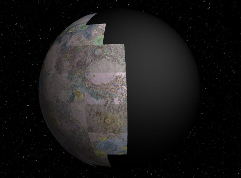
(Interactive Globe) Sheets 1-44 of the Geologic Atlas of the Moon.
List No
12101.089
Author
[U.S. Geological Survey, Graham, Joseph, Newman, William, Stacy, John]
Full Title
The Geologic Time Spiral-A Path to the Past. General Interest Publication 58.
List No
10627.000
Author
[Hackman, R.J., U.S. Geological Survey]
Full Title
Geologic Map and Sections of the Kepler Region of the Moon. MAP I - 355 (LAC-57).
List No
12101.002
Author
[Marshall, C.H., U.S. Geological Survey]
Full Title
Geologic Map and Sections of the Letronne Region of the Moon. MAP I - 385 (LAC-75).
List No
12101.004
Author
U.S. Geological Survey
Full Title
Index Map of the Earthside Hemisphere of the Moon.
List No
12101.086
Note
Shows the relative positions of the 44 sheets that make up the Geologic Atlas of the Moon. Taken from the Macrobius sheet.
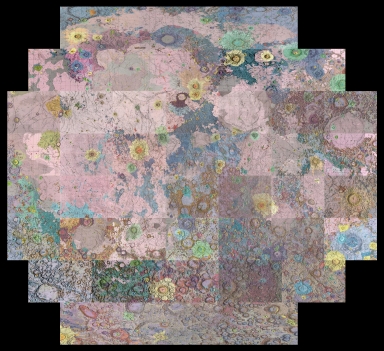
Author
U.S. Geological Survey
Full Title
(Composite map of) Sheets 1-44 of the Geologic Atlas of the Moon.
List No
12101.087
Note
Orthographic Projection.
Author
U.S. Geological Survey
Full Title
(Composite map of) Sheets 1-44 of the Geologic Atlas of the Moon.
List No
12101.088
Note
Geographic projection (unprojected)
Author
[U.S. Geological Survey, Alpha, Tau Rho]
Full Title
Central San Francisco Bay.
List No
6353.071
Author
[U.S. Geological Survey, Alpha, Tau Rho]
Full Title
Southern California Borderland.
List No
6353.087
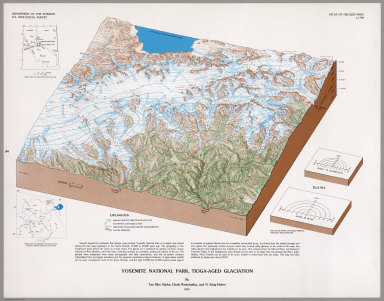
Author
[U.S. Geological Survey, Alpha, Tau Rho, Huber, N. King, Wahrhaftig, Clyde]
Full Title
Yosemite National Park, Tioga-Aged Glaciation.
List No
6353.093
Author
[Eggleton, R.E., U.S. Geological Survey]
Full Title
Geologic Map of the Riphaeus Mountains Region of the Moon. MAP I - 458 (LAC-76).
List No
12101.006
Author
[Carr, M.H., U.S. Geological Survey]
Full Title
Geologic Map and Section of the Timocharis of the Moon. MAP I - 462 (LAC-40).
List No
12101.008
Author
[Hackman, R.J., U.S. Geological Survey]
Full Title
Geologic Map of the Montes Apenninus Region of the Moon. MAP I - 463 (LAC-41).
List No
12101.010
Author
[Moore, H.J., U.S. Geological Survey]
Full Title
Geologic Map of the Aristarchus Region of the Moon. MAP I - 465 (LAC-39).
List No
12101.012
Author
[Trask, N.J.; Titley, S.R., U.S. Geological Survey]
Full Title
Geologic Map of Pitatus Region of the Moon. MAP I - 485 (LAC-94).
List No
12101.014
Author
[Carr, M.H., U.S. Geological Survey]
Full Title
Geologic Map of the Mare Serenitatus Region of the Moon. MAP I - 489 (LAC-42).
List No
12101.016
Author
[McCauley, John F., U.S. Geological Survey]
Full Title
Geologic Map of the Hevelius Region of the Moon. MAP I - 491 (LAC-56).
List No
12101.018
Author
[Titley, S.R., U.S. Geological Survey]
Full Title
Geologic Map of the Mare Humorum Region of the Moon. MAP I - 495 (LAC 93).
List No
12101.020
Author
[Morris, Elliot C., U.S. Geological Survey, Wilhelms, Don E.]
Full Title
Geologic Map of Julius Caesar Quadrangle of the Moon. MAP I - 510 (LAC-60).
List No
12101.022
Author
[Schmitt, H.H., U.S. Geological Survey, Trask, N.J., Shoemaker, E.M.]
Full Title
Geologic Map of the Copernicus Quadrangle of the Moon. MAP I - 515 (LAC-58).
List No
12101.024
Author
[Moore, H.J., U.S. Geological Survey]
Full Title
Geologic Map of the Seleucus Quadrangle of the Moon. MAP I - 527 (LAC-38).
List No
12101.026
Author
[Milton, Daniel J., U.S. Geological Survey]
Full Title
Geologic Map of the Theopilus Quadrangle of the Moon. MAP I - 546 (LAC-78).
List No
12101.028
Author
[Wilhelms, Don E., U.S. Geological Survey]
Full Title
Geologic Map of the Mare Vaporum Quadrangle of the Moon. MAP I - 548 (LAC 59).
List No
12101.030
Author
[Howard, Keith A., U.S. Geological Survey, Masursky, Harold]
Full Title
Geologic Map of the Ptolemaeus Quadrangle of the Moon. MAP I - 566 (LAC-77; RLC-13).
List No
12101.032
Author
[McCauley, John F., U.S. Geological Survey]
Full Title
Geologic Map of the Alphonsus GA of the Moon. MAP I - 586 (RLC 15).
List No
12101.034
Author
[Carr, Michael H., U.S. Geological Survey]
Full Title
Geologic Map of the Alphonsus Region of the Moon. MAP I - 599 (RLC-14).
List No
12101.036
Author
[Schaber, Gerald G., U.S. Geological Survey]
Full Title
Geologic Map of the Sinus Iridum Quadrangle of the Moon. MAP I - 602 (LAC 24).
List No
12101.038
Author
[Ulrich, G.E., U.S. Geological Survey]
Full Title
Geologic Map of the J. Herschel Quadrangle of the Moon. MAP I - 604 (LAC-11).
List No
12101.040
Author
[Page, N.J., U.S. Geological Survey]
Full Title
Geologic Map of the Cassini Quadrangle of the Moon. MAP I - 666 (LAC-25)
List No
12101.042
Author
[Rowan, L.C., U.S. Geological Survey]
Full Title
Geologic Map of the Rupes Altai Quadrangle of the Moon. MAP I - 690 (LAC 96).
List No
12101.044
Author
[Offield, Terry W., U.S. Geological Survey]
Full Title
Geologic Map of the Schiller Quadrangle of the Moon. MAP I - 691 (LAC 125).
List No
12101.046
Author
[Stuart-Alexander, Desiree E., U.S. Geological Survey]
Full Title
Geologic Map of the Rheita Quadrangle of the Moon. MAP I - 694 (LAC-114).
List No
12101.048
Author
[Scott, David H., U.S. Geological Survey]
Full Title
Geologic Map of the Maurolycus Quadrangle of the Moon. MAP I - 695 (LAC 113).
List No
12101.050
Author
[M'Gonigle, John W., U.S. Geological Survey, Schleicher, David]
Full Title
Geologic Map of the Plato Quadrangle of the Moon. MAP I - 701 (LAC-12).
List No
12101.052
Author
[Mutch, Thomas A., U.S. Geological Survey, Sunders, R. Stephen]
Full Title
Geologic Map of the Hommel Quadrangle of the Moon. MAP I - 702 (LAC 127).
List No
12101.054
Author
[Scott, David H., U.S. Geological Survey]
Full Title
Geologic Map of the Eudoxus Quadrangle of the Moon. MAP I - 705 (LAC-26).
List No
12101.056
Author
[Cummings, David, U.S. Geological Survey]
Full Title
Geologic Map of the Clavius Quadrangle of the Moon. MAP I - 706 (LAC-126).
List No
12101.058
Author
[Casella, Clarence J., U.S. Geological Survey, Binder, Alan B.]
Full Title
Geologic Map of the Cleomedes Quadrangle of the Moon. MAP I - 707 (LC 44).
List No
12101.060
Author
[Pohn, H.A., U.S. Geological Survey]
Full Title
Geologic Map of the Tycho Quadrangle of the Moon. MAP I - 713 (LAC 112).
List No
12101.062
Author
[Elston, Donald P., U.S. Geological Survey]
Full Title
Geologic Map of the Colombo Quadrangle of the Moon. MAP I - 714 (LAC-79).
List No
12101.064
Author
[Stuart-Alexander, Desiree E., U.S. Geological Survey, Tabor, Rowland W.]
Full Title
Geologic Map of the Fracastorius Quadrangle of the Moon. MAP I - 720 (LAC-97).
List No
12101.066
Author
[Wilhelms, Don E., U.S. Geological Survey]
Full Title
Geologic Map of the Taruntius Quadrangle of the Moon. MAP I - 722 (LAC-61).
List No
12101.068
Author
[Lucchitta, Baerbel Koesters, U.S. Geological Survey]
Full Title
Geologic Map of the Aristoteles Quadrangle of the Moon. MAP I - 725 (LAC-13).
List No
12101.070
Author
[Hodges, Carroll Ann, U.S. Geological Survey]
Full Title
Geologic Map of the Langrenus Quadrangle of the Moon. MAP I - 739 (LAC-80).
List No
12101.072
Author
[Scott, D.H., U.S. Geological Survey, Pohn, H.A.]
Full Title
Geologic Map of the Macrobius Quadrangle of the Moon. MAP I - 799 (LAC-43).
List No
12101.074
Author
[Pike, Richard J., U.S. Geological Survey]
Full Title
Geologic Map of the Rima Hyginus Region of the Moon. MAP I - 945.
List No
12101.076
Author
[Holt, H. E., U.S. Geological Survey]
Full Title
Geologic Map of the Purbach Quadrangle of the Moon.
List No
12101.077
Note
Image is courtesy of the online Geologic Atlas of the Moon maintained by the Lunar and Planetary Institute
Author
[Scott, D.H., U.S. Geological Survey, Eggleton, R.E.]
Full Title
Geologic Map of the Rumker Quadrangle of the Moon.
List No
12101.078
Note
Image is courtesy of the online Geologic Atlas of the Moon maintained by the Lunar and Planetary Institute
Author
[Grolier, Maurice J., U.S. Geological Survey]
Full Title
Geologic Map of the Geminus Quadrangle of the Moon.
List No
12101.079
Note
Image is courtesy of the online Geologic Atlas of the Moon maintained by the Lunar and Planetary Institute
Author
[Olson, Annable B., U.S. Geological Survey, Williams, Don E.]
Full Title
Geologic Map of the Undarem Quadrangle of the Moon.
List No
12101.080
Note
Image is courtesy of the online Geologic Atlas of the Moon maintained by the Lunar and Planetary Institute
Author
[McCauley, John F., U.S. Geological Survey]
Full Title
Geologic Map of the Grimaldi Quadrangle of the Moon.
List No
12101.081
Note
Image is courtesy of the online Geologic Atlas of the Moon maintained by the Lunar and Planetary Institute
Author
[Wilshire, H. G., U.S. Geological Survey]
Full Title
Geologic Map of the Byrgius Quadrangle of the Moon.
List No
12101.082
Note
Image is courtesy of the online Geologic Atlas of the Moon maintained by the Lunar and Planetary Institute
Author
[Hodges, Carroll Ann, U.S. Geological Survey]
Full Title
Geologic Map of the Petavius Quadrangle of the Moon.
List No
12101.083
Note
Image is courtesy of the online Geologic Atlas of the Moon maintained by the Lunar and Planetary Institute
Author
[Saunders, R. S., U.S. Geological Survey, Wilhelms, Don E.]
Full Title
Geologic Map of the Wilhelm Quadrangle of the Moon.
List No
12101.084
Note
Image is courtesy of the online Geologic Atlas of the Moon maintained by the Lunar and Planetary Institute
Author
[Karlstrom, N.V., U.S. Geological Survey]
Full Title
Geologic Map of the Schickard Quadrangle of the Moon.
List No
12101.085
Note
Image is courtesy of the online Geologic Atlas of the Moon maintained by the Lunar and Planetary Institute
Author
[Hackman, Robert J., U.S. Geological Survey]
Full Title
Engineer Special Study of the Surface of the Moon. Generalized Photogeologic Map of the Moon. Miscellaneous Geologic Investigations (1 of 4).
List No
12102.002
Note
Colored.
Author
[Hackman, Robert J., U.S. Geological Survey]
Full Title
Engineer Special Study of the Surface of the Moon. Lunar Rays. Miscellaneous Geologic Investigations (2 of 4).
List No
12102.003
Author
[Hackman, Robert J., U.S. Geological Survey, Mason, Arnold C.]
Full Title
Engineer Special Study of the Surface of the Moon. Physiographic Divisions of the Moon. Miscellaneous Geologic Investigations (3 of 4).
List No
12102.004
Author
[California. State Earthquake Investigation Commission, U.S. Geological Survey]
Full Title
California, Mt. Pinos quadrangle of the U.S. Geological Survey showing the San Andreas Rift. Earthquake Investigation Commission. (Carnegie Institution of Washington. 1908)
List No
2130.006
Note
Color. 30-minute topographic quadrangle. Relief shown by contours and spot heights. Covers portions of Ventura, Kern and Santa Barbara counties.
Author
[California. State Earthquake Investigation Commission, U.S. Geological Survey]
Full Title
California, Tejon quadrangle of the U.S. Geological Survey showing the San Andreas Rift. Earthquake Investigation Commission. (Carnegie Institution of Washington. 1908)
List No
2130.007
Note
Color. 30-minute topographic quadrangle. Relief shown by contours and spot heights. Covers portions of Kern, Los Angeles and Ventura counties.
Author
[California. State Earthquake Investigation Commission, U.S. Geological Survey]
Full Title
California, Palmdale quadrangle of the U.S. Geological Survey showing the San Andreas Rift. Earthquake Investigation Commission. A. Hoen & Co., Baltimore. (Carnegie Institution of Washington. 1908)
List No
2130.008
Note
Color. 30-minute topographic quadrangle. Relief shown by contours and spot heights. Covers portions of Kern and Los Angeles counties.
Author
[California. State Earthquake Investigation Commission, U.S. Geological Survey]
Full Title
California, Rock Creek quadrangle of the U.S. Geological Survey showing the San Andreas Rift. Earthquake Investigation Commission. Andrew B. Graham Co., Lithographers, Washington, D.C. (Carnegie Institution of Washington. 1908)
List No
2130.009
Note
Color. 15-minute topographic quadrangle. Relief shown by contours and spot heights. In Los Angeles County.
Author
[California. State Earthquake Investigation Commission, U.S. Geological Survey]
Full Title
California, San Antonio quadrangle of the U.S. Geological Survey showing the San Andreas Rift. Earthquake Investigation Commission. Andrew B. Graham Co., Lithographers, Washington, D.C. (Carnegie Institution of Washington. 1908)
List No
2130.010
Note
Color. 15-minute topographic quadrangle. Relief shown by contours and spot heights. Covers portions of Los Angeles and San Bernardino counties.
Author
[California. State Earthquake Investigation Commission, U.S. Geological Survey]
Full Title
California, Hesperia quadrangle of the U.S. Geological Survey showing the San Andreas Rift. Earthquake Investigation Commission. Andrew B. Graham Co., Lithographers, Washington, D.C. (Carnegie Institution of Washington. 1908)
List No
2130.011
Note
Color. 15-minute topographic quadrangle. Relief shown by contours and spot heights. Covers portion of San Bernardino County.
Author
[California. State Earthquake Investigation Commission, U.S. Geological Survey]
Full Title
California, San Bernardino quadrangle of the U.S. Geological Survey showing the San Andreas Rift. Earthquake Investigation Commission. Andrew B. Graham Co., Lithographers, Washington, D.C. (Carnegie Institution of Washington. 1908)
List No
2130.012
Note
Color. 15-minute topographic quadrangle. Relief shown by contours and spot heights. Covers portions of San Bernardino and Riverside counties.
Author
[California. State Earthquake Investigation Commission, U.S. Geological Survey]
Full Title
California, Redlands quadrangle of the U.S. Geological Survey showing the San Andreas Rift. Earthquake Investigation Commission. Andrew B. Graham Co., Lithographers, Washington, D.C. (Carnegie Institution of Washington. 1908)
List No
2130.013
Note
Color. 15-minute topographic quadrangle. Relief shown by contours and spot heights. Covers portions of San Bernardino and Riverside counties.
Author
[California. State Earthquake Investigation Commission, U.S. Geological Survey]
Full Title
California, San Gorgonio quadrangle of the U.S. Geological Survey showing the San Andreas Rift and the Mission Creek Fault. Earthquake Investigation Commission. Andrew B. Graham Co., Lithographers, Washington, D.C. (Carnegie Institution of Washington. 1908)
List No
2130.014
Note
Color. 30-minute topographic quadrangle. Relief shown by contours and spot heights. Covers portions of San Bernardino and Riverside counties.
Author
[California. State Earthquake Investigation Commission, U.S. Geological Survey]
Full Title
California, San Jacinto quadrangle of the U.S. Geological Survey showing the San Andreas Rift, the Mission Creek Fault and the San Jacinto Fault. Earthquake Investigation Commission. Andrew B. Graham Co., Lithographers, Washington, D.C. (Carnegie Institution of Washington. 1908)
List No
2130.015
Note
Color. 30-minute topographic quadrangle. Relief shown by contours and spot heights. Covers portions of Riverside County.
Author
[California. State Earthquake Investigation Commission, U.S. Geological Survey]
Full Title
California, San Mateo quadrangle of the U.S. Geological Survey showing the distribution of apparent intensity, the known faults, and the routes examined. Earthquake Investigation Commission. A. Hoen & Co., Baltimore. (Carnegie Institution of Washington. 1908)
List No
2130.021
Note
Color. 15-minute topographic quadrangle. Relief shown by contours and spot heights. Covers portions of San Mateo and San Francisco counties. Rossi-Forel scale.
Author
[California. State Earthquake Investigation Commission, U.S. Geological Survey]
Full Title
California, Santa Cruz quadrangle of the U.S. Geological Survey showing the distribution of apparent intensity, the known faults, the routes examined and the numbered localities referred to in the text. Earthquake Investigation Commission. A. Hoen & Co., Baltimore. (Carnegie Institution of Washington. 1908)
List No
2130.022
Note
Color. 30-minute topographic quadrangle. Relief shown by contours and spot heights. Covers portions of San Mateo, Santa Clara and Santa Cruz counties. Rossi-Forel scale.
Author
[U.S. Geological Survey, Schmidt, Robert G., Shaw, Herbert R.]
Full Title
Magma and Lava.
List No
6352.001
Author
[U.S. Geological Survey, Schmidt, Robert G., Shaw, Herbert R.]
Full Title
Magmatic Differentiation.
List No
6352.002
Author
[U.S. Geological Survey, Schmidt, Robert G.]
Full Title
Distribution and Environment of Volcanoes.
List No
6352.003
Author
[U.S. Geological Survey, Schmidt, Robert G.]
Full Title
Shield Volcanoes.
List No
6352.004
Author
[U.S. Geological Survey, Schmidt, Robert G.]
Full Title
Cinder Cones.
List No
6352.005
Author
[U.S. Geological Survey, Schmidt, Robert G.]
Full Title
Composite Volcanoes.
List No
6352.006
Author
[U.S. Geological Survey, Schmidt, Robert G.]
Full Title
Volcanic Domes.
List No
6352.007
Author
[U.S. Geological Survey, Schmidt, Robert G.]
Full Title
Evolution and Erosion of a Composite Volcano.
List No
6352.008
Author
[U.S. Geological Survey, Schmidt, Robert G., Bailey, Roy A.]
Full Title
Calderas.
List No
6352.009
Author
[U.S. Geological Survey, Schmidt, Robert G., Smith, Robert L.]
Full Title
Ash Flows.
List No
6352.010
Author
[U.S. Geological Survey, Fiske, Richard S.]
Full Title
Flood Basalts of the Columbia River Plateau.
List No
6352.011
Author
[U.S. Geological Survey, Fiske, Richard S.]
Full Title
Submarine Volcanoes.
List No
6352.012
Author
[U.S. Geological Survey, Schmidt, Robert G., Hearn Jr., B. Carter]
Full Title
Maars, Diatremes and Cryptovolcanic Structures.
List No
6352.013
Author
[U.S. Geological Survey, Schmidt, Robert G., Hearn Jr., B. Carter]
Full Title
Development of a Diatreme.
List No
6352.014
Author
[U.S. Geological Survey, White, Donald E.]
Full Title
Geyers, Solfataras and Hot Springs.
List No
6352.015
Author
[U.S. Geological Survey, Schmidt, Robert G.]
Full Title
Types of Volcanic Eruptions.
List No
6352.016
Author
[U.S. Geological Survey, Schmidt, Robert G.]
Full Title
Hawaiian Volcanic Observatory - Studies of Volcanic Products and Processes.
List No
6352.017
Author
[U.S. Geological Survey, Schmidt, Robert G.]
Full Title
Hawaiian Volcanic Observatory.
List No
6352.018
Author
[U.S. Geological Survey, Schmidt, Robert G., Eaton, Jerry P.]
Full Title
Kilauea.
List No
6352.019
Author
[U.S. Geological Survey, Schmidt, Robert G.]
Full Title
Volcanism and Human Affairs.
List No
6352.020
Author
[U.S. Geological Survey, Alpha, Tau Rho, Detterman, Janis S., Morley, James M.]
Full Title
(Index Map) Location of Oblique Maps in Alaska and the North Pacific.
List No
6353.009
Author
[U.S. Geological Survey, Alpha, Tau Rho, Gerin, Marybeth, Joyce, James M.]
Full Title
Oblique Map of the Gulf of Alaska.
List No
6353.010
Author
[U.S. Geological Survey, Alpha, Tau Rho]
Full Title
The Aleutian-Kamchatka Convergence, North Pacific Ocean.
List No
6353.011
Author
[U.S. Geological Survey, Alpha, Tau Rho]
Full Title
Central Aleutian Arc, Alaska.
List No
6353.012
Author
[U.S. Geological Survey, Alpha, Tau Rho, Winegard, Charles I.]
Full Title
Eastern Aleutian Trench and Northern Gulf of Alaska.
List No
6353.013
Author
[U.S. Geological Survey, Alpha, Tau Rho]
Full Title
A Part of the Eastern Aleutian Trench.
List No
6353.014
Author
[U.S. Geological Survey, Alpha, Tau Rho, Scholl, David W., Vallier, T.L.]
Full Title
Amlia Corridor, Alaska.
List No
6353.015
Author
[U.S. Geological Survey, Alpha, Tau Rho, Morley, James M., Eittreim, Stephen]
Full Title
Barrow Canyon, Alaska.
List No
6353.016
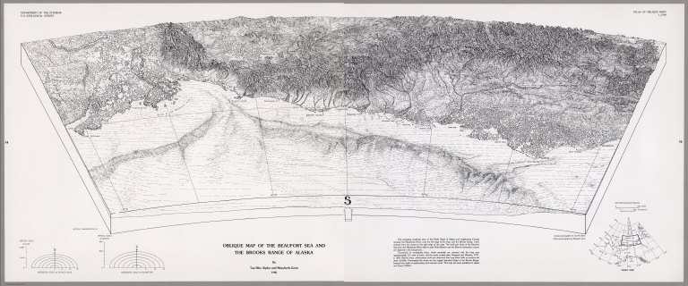
Author
[U.S. Geological Survey, Alpha, Tau Rho, Gerin, Marybeth]
Full Title
Oblique Map of the Beaufort Sea and the Brooks Range of Alaska.
List No
6353.017
Author
[U.S. Geological Survey, Alpha, Tau Rho]
Full Title
Bering Canyon, Aleutian Islands, Alaska.
List No
6353.018
|