|
REFINE
Browse All : Military and Separate Map by U.S. War Department, Topographical Engineers
1-5 of 5
U.S. War Department, Topographical Engin... Siege Of Vera Cruz, by the U.S. Troops 1847 3482.000 Related Author
U.S. War Department, Topographical Engineers
Full Title
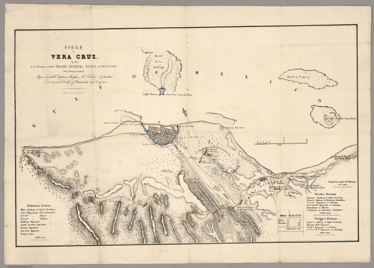
Siege Of Vera Cruz, by the U.S. Troops under Major General Scott, in March 1847, from Surveys made by Major Turnbull, Captains Hughes, McClellan & Johnston; Lieutenants Derby & Hardcastle, Topl. Engineers. Drawn by Capt. McClellan.
List No
3482.000
Note
Separately published map of an important Mexican War battle. Not in the large group of maps on the war published in Message of the President in the same year (see our copy). Hand colored outline map, Shows military fortifications, and roads. Relief shown by hachures.
Author
U.S. War Department, Topographical Engineers
Full Title
Part of Washington County, MD. Bureau of Topographical Engineers September, 1862.
List No
3844.000
Note
Unusual large scale contemporary photographic copy of a part of a land ownership map somewhat crudely drawn.
U.S. War Department, Topographical Engin... Sketch Of Country Between Haxall's Landi... 1862 3845.000 Related Author
U.S. War Department, Topographical Engineers
Full Title
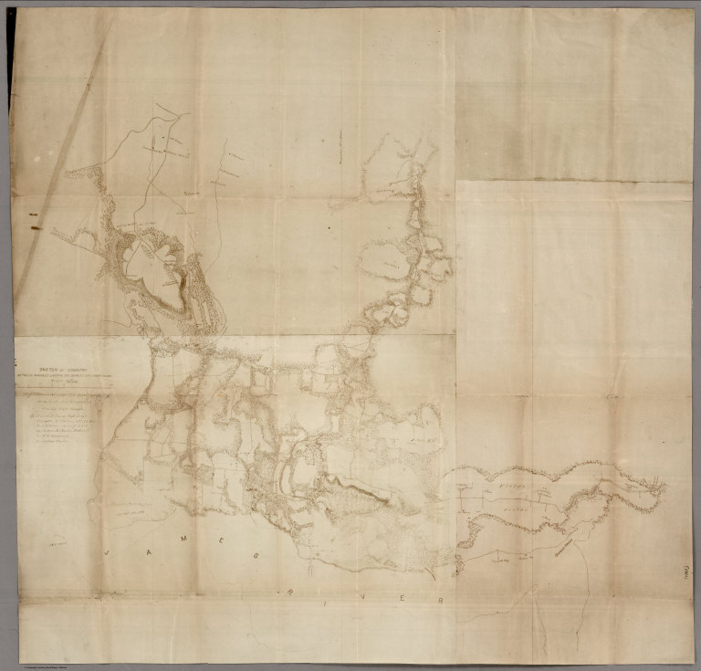
Sketch Of Country Between Haxall's Landing And Charles City Court House. Reconnoissances under the direction of Brig. Gen A.A. Humphreys, Comdg. Topl Engr's, by 1st Lieut. N. Bowen, Topl. Engrs., 2d Lieut. C. McClellan, 32d N.Y.. Vols., Mr. F.W. Dorr, Assist. U.S.C.S., Mr. Joseph McMakin, Drftsmn., Mr. H.H. Humpheys, Mr. Walter Taylor.
List No
3845.000
Note
Contemporary photographic copy. This copy is more complete than the LOC copy. From an original drawing. Relief shown by hachures. Shows roads and trails, houses and names of residents, rivers, streams, and woodland.
U.S. War Department, Topographical Engin... Map Of N. Eastern Virginia And Vicinity ... 1862 3859.000 Related Author
U.S. War Department, Topographical Engineers
Full Title
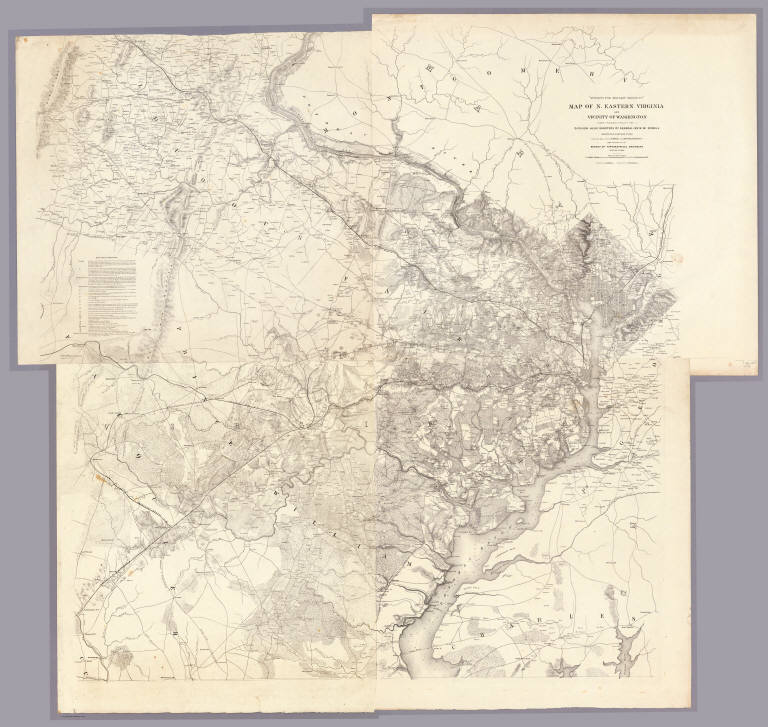
"Surveys For Military Defences" Map Of N. Eastern Virginia And Vicinity Of Washington compiled in Topographical Engineers Office at Division Head Quarters Of General Irvin McDowell Arlington, January 1th 1862 corrected from recent Surveys and Reconnaissances under the direction of the Bureau Of Topographical Engineers August 1st 1862. Drawn By J.J. Young, W. Hesselbach. Engr. On Stone By J. Schedler, No. 120 Pearl St. N.Y. ...
List No
3859.000
Note
Second edition. Four separate sheets. Very accurate and dense map showing the country around and west of Washington, which was the first detailed map of Northern Virginia for use in the Civil War. The first edition appeared in January of 1862 (Stephenson 466) and extended further south to include Fredericksburg; this second edition extends south to Morrisburg. "Data Used in Compilation" appears in the upper left sheet and shows Surveys, Reconnaissances, Informations, Maps, Manuscripts, and Additions and Corrections. The first edition is plate 7:1, 8:1 in the "Atlas to Accompany..." Illustrated in Stephenson.
U.S. War Department, Topographical Engin... Map of Texas and part of New Mexico. 1857 5141.000 Related Author
U.S. War Department, Topographical Engineers
Full Title
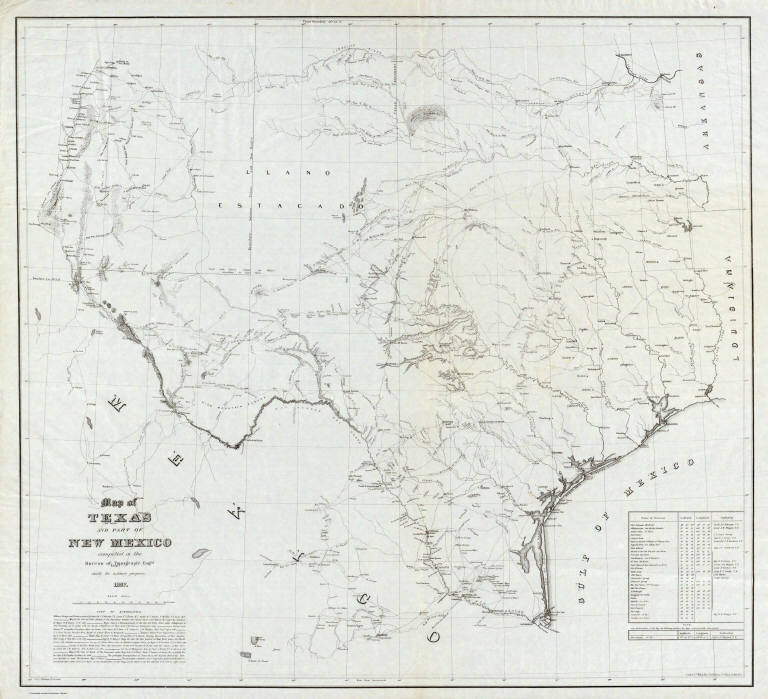
Map of Texas and part of New Mexico compiled in the Bureau of Topgraphl. Eng'rs. chiefly for military purposes, 1857 ... Lith. of Ritchie & Dunnovant. Printed at H.F. Walling's Map Establishment, 90 Fulton St., New York.
List No
5141.000
Note
Probably the best and most detailed military map of Texas issued before the Civil War - rivers, roads, explorer's routes, water holes, forts and towns are shown. Includes "List of authorities." The Warren map of 1857 (see our #4013) incorporates much of this information, with even more information from this map appearing on the Warren map of 1858 (see our #2750). A later version of this map appeared in the Atlas To Accompany The Official Records of the Union and Confederate Armies (see our #1780) as plate 54. Martin and Martin incorrectly state that the map was not published until it appeared in the "Atlas to Accompany..." This is the only government map published by H.F. Walling that we know of. This copy came from a group of about ten copies found with the J.D. Graham papers. Without color. Scarce. Relief shown by hachures.
1-5 of 5
|