|
Author
[U.S. Geological Survey, Bailey, Roy A., Alpha, Tau Rho, Lojoie, Kenneth R., Clark, Malcolm M.]
Full Title
Physiographic Diagrams of Long Valley, Mono and Inyo Counties, California.
List No
6353.072
Author
[U.S. Geological Survey, Bailey, Roy A., Alpha, Tau Rho, Lojoie, Kenneth R., Clark, Malcolm M.]
Full Title
Physiographic Diagrams of Long Valley, Mono and Inyo Counties, California. - Continued.
List No
6353.073
Author
[U.S. Geological Survey, Alpha, Tau Rho]
Full Title
Monarch Divide, Kings Canyon National Park.
List No
6353.074
Author
[U.S. Geological Survey, Bailey, Roy A., Alpha, Tau Rho, Morley, James M.]
Full Title
Oblique Map of Mono-Inyo Craters, California.
List No
6353.075
Author
[U.S. Geological Survey, Alpha, Tau Rho]
Full Title
Oblique Map of Monterey Bay.
List No
6353.076
Author
[U.S. Geological Survey, Alpha, Tau Rho]
Full Title
Southern Monterey Bay.
List No
6353.077
Note
Geologic interpretation by H. Gary Greene.
Author
[U.S. Geological Survey, Greene, H. Gary]
Full Title
Basement Topography, Monterey Bay Region, California.
List No
6353.078
Author
[U.S. Geological Survey, Alpha, Tau Rho]
Full Title
Monterey Canyon.
List No
6353.079
Author
[U.S. Geological Survey, Alpha, Tau Rho]
Full Title
Diagram Showing Different Stages of Slumping in Monterey Canyon and Relation to Water-Bearing Rocks.
List No
6353.080
Author
[U.S. Geological Survey, Alpha, Tau Rho]
Full Title
Mount Whitney and Vicinity, Tulare and Inyo Counties, California.
List No
6353.081
Author
[U.S. Geological Survey, Alpha, Tau Rho]
Full Title
Eastern Murray Fracture Zone and Transverse Ranges.
List No
6353.082
Author
[U.S. Geological Survey, Alpha, Tau Rho, Gerin, Marybeth]
Full Title
Oblique Map of the Northern California Continental Margin.
List No
6353.083
Author
[U.S. Geological Survey, Alpha, Tau Rho]
Full Title
Pickett Peak Quadrangle, California
List No
6353.084
Author
[U.S. Geological Survey, Alpha, Tau Rho, Detterman, Janis S., Morley, James M.]
Full Title
Compilation of the Oblique Map of Sequoia and Kings Canyon National Parks.
List No
6353.085
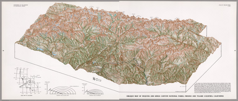
Author
[U.S. Geological Survey, Alpha, Tau Rho]
Full Title
Oblique Map of Sequoia and Kings Canyon National Parks, Fresno and Tulare Counties, California.
List No
6353.086
Author
[U.S. Geological Survey, Alpha, Tau Rho]
Full Title
Oblique Map of Southern California, Santa Barbara to San Deigo.
List No
6353.088
Author
[U.S. Geological Survey, Alpha, Tau Rho]
Full Title
Southern California Borderland Oblique Map of the Northwestern Part.
List No
6353.089
Author
[U.S. Geological Survey, Alpha, Tau Rho, Normark, William R., Hess, Gordon R.]
Full Title
Suprafan, Part of the Navy Submarine Fan, California Continental Borderland.
List No
6353.090
Author
[U.S. Geological Survey, Alpha, Tau Rho]
Full Title
Ventura-Oxnard Offshore.
List No
6353.091
Author
[U.S. Geological Survey, Alpha, Tau Rho, Huber, N. King, Wahrhaftig, Clyde]
Full Title
Oblique Map of Yosemite National Park, Central Sierra Nevada, California.
List No
6353.092
Author
[U.S. Geological Survey, Alpha, Tau Rho]
Full Title
Island of Hawaii, Hawaii.
List No
6353.096
Author
[U.S. Geological Survey, Alpha, Tau Rho, Morley, James M., Austin, William A., Gutmacher, Christina E.]
Full Title
Oblique Map of the Loihi Seamount and the Papua Landslide, Hawaii.
List No
6353.097
Author
[U.S. Geological Survey, Alpha, Tau Rho, Greene, H. Gary]
Full Title
Oblique Map of Rabaul, Papua New Guinea.
List No
6353.098
Author
[U.S. Geological Survey, Alpha, Tau Rho, Morley, James M., Austin, William A.]
Full Title
Oblique Map of the Solomon Islands, Southwest Pacific.
List No
6353.099
Author
[U.S. Geological Survey, Alpha, Tau Rho, Morley, James M.]
Full Title
Oblique Map of Southwest Pacific.
List No
6353.100
Author
[U.S. Geological Survey, Alpha, Tau Rho, Morley, James M., Austin, William A.]
Full Title
Oblique Map of the Kingdom of Tonga, Southwest Pacific.
List No
6353.101
Author
[U.S. Geological Survey, Alpha, Tau Rho, Morley, James M., Austin, William A.]
Full Title
Oblique Map of the Republic of Vanuatu, Southwest Pacific.
List No
6353.102
Author
[U.S. Geological Survey, Alpha, Tau Rho, Detterman, Janis S., Morley, James M.]
Full Title
(Section Title Page) Caribbean and Gulf of Mexico.
List No
6353.103
Note
Preceded by blank page.
Author
[U.S. Geological Survey, Alpha, Tau Rho, Detterman, Janis S., Morley, James M.]
Full Title
(Index Map) Location of Oblique Maps in the Caribbean and the Gulf of Mexico.
List No
6353.104
Author
[U.S. Geological Survey, Alpha, Tau Rho]
Full Title
Bahia de Compeche.
List No
6353.105
Author
[U.S. Geological Survey, Alpha, Tau Rho]
Full Title
British Honduras.
List No
6353.106
Author
[U.S. Geological Survey, Alpha, Tau Rho]
Full Title
Caribbean Arc-Hispaniola to Guadeloupe.
List No
6353.107
Author
[U.S. Geological Survey, Alpha, Tau Rho]
Full Title
Northeast Caribbean Sea.
List No
6353.108
Author
[U.S. Geological Survey, Alpha, Tau Rho, Maher, J.C.]
Full Title
Physiographic Diagram of the Gulf of Mexico.
List No
6353.109
Author
[U.S. Geological Survey, Alpha, Tau Rho]
Full Title
Venezuelan Borderlands.
List No
6353.110
Author
[U.S. Geological Survey, Alpha, Tau Rho, Detterman, Janis S., Morley, James M.]
Full Title
(Section Title Page) Other Places. (Index Map) (World Places).
List No
6353.111
Note
Transverse aspect of Mollweide's Homolographic Projection.
Author
[U.S. Geological Survey, Alpha, Tau Rho]
Full Title
Almeria, Espana.
List No
6353.112
Author
[U.S. Geological Survey, Alpha, Tau Rho, Maher, J.A.]
Full Title
Physiographic Diagram of Atlantic Coastal Plain and Continental Shelf of North America.
List No
6353.113
Author
[U.S. Geological Survey, Alpha, Tau Rho]
Full Title
Oblique Map of the Atlantic Continental Margin of North America.
List No
6353.114
Author
[U.S. Geological Survey, Alpha, Tau Rho, Maher, John C.]
Full Title
Physiographic Diagram of Bahama Banks, Bahamas.
List No
6353.115
Author
[U.S. Geological Survey, Alpha, Tau Rho, Dillon, William P., Forrestel, Patricia, Zwinakis, Jeff]
Full Title
Physiographic Diagram of the Blake Escarpment Off Southeastern United States.
List No
6353.116
Author
[U.S. Geological Survey, Alpha, Tau Rho]
Full Title
Oblique Map of the Crest of the East Pacific Rise near the Mouth of the Gulf of California.
List No
6353.117
Author
[U.S. Geological Survey, Alpha, Tau Rho]
Full Title
Oblique Map of the Falkland Plateau Region.
List No
6353.118
Author
[U.S. Geological Survey, Alpha, Tau Rho]
Full Title
Oblique Map of the May 31, 1970, Debris Avalanche, Huascaran Mountain, Peru.
List No
6353.119
Note
The Ancash Earthquake triggered an avalanche of snow, ice, and rock which killed 20,000 people.
Author
[U.S. Geological Survey, Alpha, Tau Rho]
Full Title
Hudson Canyon, North Atlantic Ocean.
List No
6353.120
Author
[U.S. Geological Survey, Alpha, Tau Rho]
Full Title
Mid-Atlantic Ridge at Latitude 38°48' North, North Atlantic Ocean.
List No
6353.121
Author
[U.S. Geological Survey, Alpha, Tau Rho]
Full Title
Schematic Block Diagram of the Head of the Rio Balsas Canyon, Canon de la Necesidad, Mexico.
List No
6353.122
Author
[U.S. Geological Survey, Alpha, Tau Rho]
Full Title
Oblique Map of the Ross Sea Continental Shelf, Antarctica.
List No
6353.123
Author
[U.S. Geological Survey, Alpha, Tau Rho]
Full Title
Upper Verde River, Arizona.
List No
6353.124
Author
[U.S. Geological Survey, Alpha, Tau Rho, Detterman, Janis S., Morley, James M.]
Full Title
(Section Title Page) Cognitive Drawings.
List No
6353.125
|