|
Author
Dutton, Clarence E. (Clarence Edward), 1841-1912
Full Title
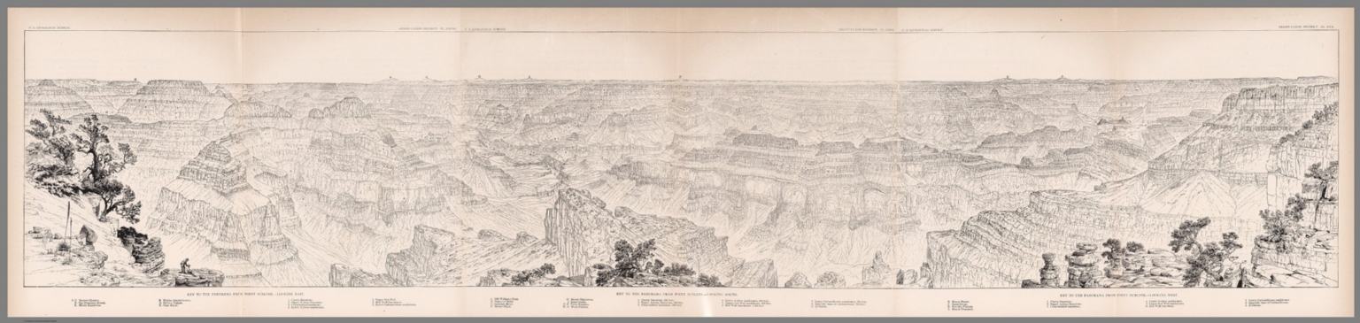
(View) Pl. XXIX. Key to the Panorama from Point Sublime - Looking South.
List No
2147.044
Author
Dutton, Clarence E. (Clarence Edward), 1841-1912
Full Title
(View) Pl. XXX. Key to the Panorama from Point Sublime - Looking West.
List No
2147.045
Author
Dutton, Clarence E. (Clarence Edward), 1841-1912
Full Title
(Composite view of) Pl. XXVIII, XXIX, XXX. Key to the Panorama from Point Sublime.
List No
2147.058
Author
Dutton, Clarence E. (Clarence Edward), 1841-1912
Full Title
(View) Pl. XXXI. Granite Falls - Kaibab Division - Grand Canyon.
List No
2147.046
Author
Dutton, Clarence E. (Clarence Edward), 1841-1912
Full Title
(View) Pl. XXXII. Pinnacles - Kaibab.
List No
2147.047
Author
Dutton, Clarence E. (Clarence Edward), 1841-1912
Full Title
(View) Pl. XXXIII. An Alcove - In the Red Wall - Kaibab.
List No
2147.048
Author
Dutton, Clarence E. (Clarence Edward), 1841-1912
Full Title
(View) Pl. XXXIV. Vishnu's Temple.
List No
2147.049
Author
Dutton, Clarence E. (Clarence Edward), 1841-1912
Full Title
(View) Pl. XXXV. The Great Unconformity at the Head of the Grand Canyon.
List No
2147.050
Author
Dutton, Clarence E. (Clarence Edward), 1841-1912
Full Title
(View) Pl. XXXVI. The Marble Canyon.
List No
2147.051
Author
Dutton, Clarence E. (Clarence Edward), 1841-1912
Full Title
(View) Pl. XXXVII. Head of the Grand Canyon.
List No
2147.052
Author
Dutton, Clarence E. (Clarence Edward), 1841-1912
Full Title
(View) Pl. XXXVIII. A Canyon Refilled with Alluvium.
List No
2147.053
Author
Dutton, Clarence E. (Clarence Edward), 1841-1912
Full Title
(View) Pl. XXXIX. Profile of the River Bed in the Grand and Marble Canyon.
List No
2147.054
Author
Dutton, Clarence E. (Clarence Edward), 1841-1912
Full Title
(View) Pl. XL. Development of Cliff Profiles.
List No
2147.055
Author
Dutton, Clarence E. (Clarence Edward), 1841-1912
Full Title
(View) Pl. XLI. Niches or Panels in the Red Wall Limestone.
List No
2147.056
Author
Dutton, Clarence E. (Clarence Edward), 1841-1912
Full Title
(View) Pl. XLII. Rounded Inward Curves and Projecting Cusps of the Wall.
List No
2147.057
Author
[King, Clarence, U.S. Geological Survey]
Full Title
(Covers to) First Annual Report of the United States Geological Survey. To the Hon. Carl Schurz, Secretary of the Interior. By Clarence King, Director. Washington: Government Printing Office. 1880.
List No
2935.001
Note
King's first and last report. First report of the Survey. Includes a large map of the United States by Julius Bien entitled, "Map Showing Geographical Divisions of the U.S. Geological Survey, 1880." All of the divisions are named. Bound with purple cloth covers and the title "Report of the United States Geological Survey : Clarence King, Director. 1880." embossed on the cover in gold.
Author
[King, Clarence, U.S. Geological Survey]
Full Title
(Title Page to) First Annual Report of the United States Geological Survey. To the Hon. Carl Schurz, Secretary of the Interior. By Clarence King, Director. Washington: Government Printing Office. 1880.
List No
2935.002
Note
King's first and last report. First report of the Survey. Includes a large map of the United States by Julius Bien entitled, "Map Showing Geographical Divisions of the U.S. Geological Survey, 1880." All of the divisions are named. Bound with purple cloth covers and the title "Report of the United States Geological Survey : Clarence King, Director. 1880." embossed on the cover in gold.
Author
[King, Clarence, U.S. Geological Survey]
Full Title
Map Showing Geographical Divisions of the U.S. Geological Survey, 1880. Department of Interior U.S. Geological Survey, Clarence King, Director. Julius Bien, Lith, N.Y. (to accompany) First Annual Report of the United States Geological Survey. To the Hon. Carl Schurz, Secretary of the Interior. By Clarence King, Director. Washington: Government Printing Office. 1880.
List No
2935.003
Note
Color map. Relief shown by hachures. "Colored areas indicate divisions now organized."
Author
U.S. General Land Office
Full Title
Territory of Arizona. 1896. Compiled from the Official Records of the General Land Office and other Sources under Supervision of Harry King, G.E. Chief of Drafting Division, G.L.O. ; Revised and Reconstructed by R.H. Morton. (Sequence of ten maps of the Territory of Arizona, 1896, 1901, 1902, 1903, 1905, 1906, 1907, 1908, 1909, 1910 from the Annual Reports of the Governor of Arizona. With: Report of the Governor of Arizona for each of those years, plus the years 1897 and 1904, for which no maps were issued.)
List No
3773.001
Note
Ten maps each 52x43 cm., printed with outline and full color. Not in Kelsay, these maps record the development of the territory over a fourteen year period. These are smaller than the usual GLO maps and may have been made specially for the Territorial Annual Reports. Shows private claims confirmed and unconfirmed, Indian, military, and forest reservations. Relief shown by shading. Prime meridians are Greenwich and Washington D.C.
Author
U.S. General Land Office
Full Title
Territory of Arizona. 1901. Compiled from the Official Records of the General Land Office and other Sources under Supervision of Harry King, G.E. Chief of Drafting Division, G.L.O. ; Revised and Reconstructed by R.H. Morton. (Sequence of ten maps of the Territory of Arizona, 1896, 1901, 1902, 1903, 1905, 1906, 1907, 1908, 1909, 1910 from the Annual Reports of the Governor of Arizona. With: Report of the Governor of Arizona for each of those years, plus the years 1897 and 1904, for which no maps were issued.)
List No
3773.002
Note
Ten maps each 52x43 cm., printed with outline and full color. Not in Kelsay, these maps record the development of the territory over a fourteen year period. These are smaller than the usual GLO maps and may have been made specially for the Territorial Annual Reports. Shows private claims confirmed and unconfirmed, Indian, military, and forest reservations. Relief shown by shading. Prime meridians are Greenwich and Washington D.C.
Author
U.S. General Land Office
Full Title
Territory of Arizona. 1902. Compiled from the Official Records of the General Land Office and other Sources under Supervision of Harry King, G.E. Chief of Drafting Division, G.L.O. ; Revised and Reconstructed by R.H. Morton. (Sequence of ten maps of the Territory of Arizona, 1896, 1901, 1902, 1903, 1905, 1906, 1907, 1908, 1909, 1910 from the Annual Reports of the Governor of Arizona. With: Report of the Governor of Arizona for each of those years, plus the years 1897 and 1904, for which no maps were issued.)
List No
3773.003
Note
Ten maps each 52x43 cm., printed with outline and full color. Not in Kelsay, these maps record the development of the territory over a fourteen year period. These are smaller than the usual GLO maps and may have been made specially for the Territorial Annual Reports. Shows private claims confirmed and unconfirmed, Indian, military, and forest reservations. Relief shown by shading. Prime meridians are Greenwich and Washington D.C.
Author
U.S. General Land Office
Full Title
Territory of Arizona. 1903. Compiled from the Official Records of the General Land Office and other Sources under Supervision of Harry King, G.E. Chief of Drafting Division, G.L.O. ; Revised and Reconstructed by R.H. Morton. (Sequence of ten maps of the Territory of Arizona, 1896, 1901, 1902, 1903, 1905, 1906, 1907, 1908, 1909, 1910 from the Annual Reports of the Governor of Arizona. With: Report of the Governor of Arizona for each of those years, plus the years 1897 and 1904, for which no maps were issued.)
List No
3773.004
Note
Ten maps each 52x43 cm., printed with outline and full color. Not in Kelsay, these maps record the development of the territory over a fourteen year period. These are smaller than the usual GLO maps and may have been made specially for the Territorial Annual Reports. Shows private claims confirmed and unconfirmed, Indian, military, and forest reservations. Relief shown by shading. Prime meridians are Greenwich and Washington D.C.
Author
U.S. General Land Office
Full Title
Territory of Arizona. 1905. Compiled from the Official Records of the General Land Office and other Sources under Supervision of Harry King, G.E. Chief of Drafting Division, G.L.O. ; Revised and Reconstructed by R.H. Morton. (Sequence of ten maps of the Territory of Arizona, 1896, 1901, 1902, 1903, 1905, 1906, 1907, 1908, 1909, 1910 from the Annual Reports of the Governor of Arizona. With: Report of the Governor of Arizona for each of those years, plus the years 1897 and 1904, for which no maps were issued.)
List No
3773.005
Note
Ten maps each 52x43 cm., printed with outline and full color. Not in Kelsay, these maps record the development of the territory over a fourteen year period. These are smaller than the usual GLO maps and may have been made specially for the Territorial Annual Reports. Shows private claims confirmed and unconfirmed, Indian, military, and forest reservations. Relief shown by shading. Prime meridians are Greenwich and Washington D.C.
Author
U.S. General Land Office
Full Title
Territory of Arizona. 1906. Compiled from the Official Records of the General Land Office and other Sources under Supervision of Harry King, G.E. Chief of Drafting Division, G.L.O. ; Revised and Reconstructed by R.H. Morton. (Sequence of ten maps of the Territory of Arizona, 1896, 1901, 1902, 1903, 1905, 1906, 1907, 1908, 1909, 1910 from the Annual Reports of the Governor of Arizona. With: Report of the Governor of Arizona for each of those years, plus the years 1897 and 1904, for which no maps were issued.)
List No
3773.006
Note
Ten maps each 52x43 cm., printed with outline and full color. Not in Kelsay, these maps record the development of the territory over a fourteen year period. These are smaller than the usual GLO maps and may have been made specially for the Territorial Annual Reports. Shows private claims confirmed and unconfirmed, Indian, military, and forest reservations. Relief shown by shading. Prime meridians are Greenwich and Washington D.C.
Author
U.S. General Land Office
Full Title
Territory of Arizona. 1907. Compiled from the Official Records of the General Land Office and other Sources under Supervision of Harry King, G.E. Chief of Drafting Division, G.L.O. ; Revised and Reconstructed by R.H. Morton. (Sequence of ten maps of the Territory of Arizona, 1896, 1901, 1902, 1903, 1905, 1906, 1907, 1908, 1909, 1910 from the Annual Reports of the Governor of Arizona. With: Report of the Governor of Arizona for each of those years, plus the years 1897 and 1904, for which no maps were issued.)
List No
3773.007
Note
Ten maps each 52x43 cm., printed with outline and full color. Not in Kelsay, these maps record the development of the territory over a fourteen year period. These are smaller than the usual GLO maps and may have been made specially for the Territorial Annual Reports. Shows private claims confirmed and unconfirmed, Indian, military, and forest reservations. Relief shown by shading. Prime meridians are Greenwich and Washington D.C.
Author
U.S. General Land Office
Full Title
Territory of Arizona. 1908. Compiled from the Official Records of the General Land Office and other Sources under Supervision of Harry King, G.E. Chief of Drafting Division, G.L.O. ; Revised and Reconstructed by R.H. Morton. (Sequence of ten maps of the Territory of Arizona, 1896, 1901, 1902, 1903, 1905, 1906, 1907, 1908, 1909, 1910 from the Annual Reports of the Governor of Arizona. With: Report of the Governor of Arizona for each of those years, plus the years 1897 and 1904, for which no maps were issued.)
List No
3773.008
Note
Ten maps each 52x43 cm., printed with outline and full color. Not in Kelsay, these maps record the development of the territory over a fourteen year period. These are smaller than the usual GLO maps and may have been made specially for the Territorial Annual Reports. Shows private claims confirmed and unconfirmed, Indian, military, and forest reservations. Relief shown by shading. Prime meridians are Greenwich and Washington D.C.
Author
U.S. General Land Office
Full Title
Territory of Arizona. 1909. Compiled from the Official Records of the General Land Office and other Sources under Supervision of Harry King, G.E. Chief of Drafting Division, G.L.O. ; Revised and Reconstructed by R.H. Morton. (Sequence of ten maps of the Territory of Arizona, 1896, 1901, 1902, 1903, 1905, 1906, 1907, 1908, 1909, 1910 from the Annual Reports of the Governor of Arizona. With: Report of the Governor of Arizona for each of those years, plus the years 1897 and 1904, for which no maps were issued.)
List No
3773.009
Note
Ten maps each 52x43 cm., printed with outline and full color. Not in Kelsay, these maps record the development of the territory over a fourteen year period. These are smaller than the usual GLO maps and may have been made specially for the Territorial Annual Reports. Shows private claims confirmed and unconfirmed, Indian, military, and forest reservations. Relief shown by shading. Prime meridians are Greenwich and Washington D.C.
Author
U.S. General Land Office
Full Title
Territory of Arizona. 1910. Compiled from the Official Records of the General Land Office and other Sources under Supervision of Harry King, G.E. Chief of Drafting Division, G.L.O. ; Revised and Reconstructed by R.H. Morton. (Sequence of ten maps of the Territory of Arizona, 1896, 1901, 1902, 1903, 1905, 1906, 1907, 1908, 1909, 1910 from the Annual Reports of the Governor of Arizona. With: Report of the Governor of Arizona for each of those years, plus the years 1897 and 1904, for which no maps were issued.)
List No
3773.010
Note
Ten maps each 52x43 cm., printed with outline and full color. Not in Kelsay, these maps record the development of the territory over a fourteen year period. These are smaller than the usual GLO maps and may have been made specially for the Territorial Annual Reports. Shows private claims confirmed and unconfirmed, Indian, military, and forest reservations. Relief shown by shading. Prime meridians are Greenwich and Washington D.C.
Author
U.S. Geological Survey
Full Title
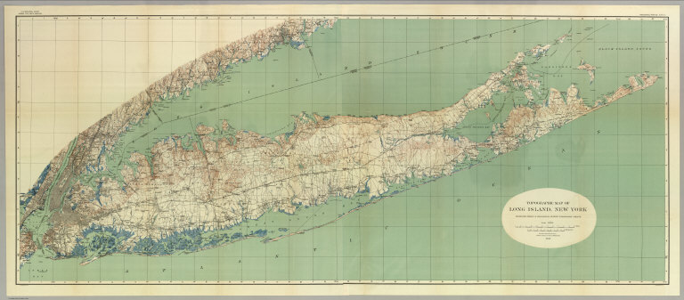
Topographical Map Of Long Island, New York. Engraved From U.S. Geological Survey Topographic Sheets ... 1913. Julius Bien Co. Lith. N.Y. U.S. Geological Survey, George Otis Smith, Director. Professional Paper 82 Plate II.
List No
4230.000
Note
Large scale map of the island with relief by contours, all roads and railroads, and showing the growth of development from the western to the eastern parts of the island. With printed color.
Author
U.S. Geological Survey
Full Title
San Francisco and vicinity, California. From Geological Survey atlas sheets surveyed in 1892-1913.
List No
10107.000
Note
This is a duplicate copy of our 5742.000. Covers San Francisco and San Pablo Bay areas. Relief shown by contours and spot heights. Shows wetlands, roads, streets, buildings, railroads, etc. Title in upper margin: Topography, California, San Francisco Bay and vicinity. "Culture revision of San Francisco, Oakland, Alameda, Berkeley, and Richmond in 1913-1914. R.B. Marshall, Chief Geographer." Owned by Michael Moore.
Author
U.S. Geological Survey
Full Title
San Francisco and vicinity, California. From Geological Survey atlas sheets surveyed in 1892-1913.
List No
5742.000
Note
Covers San Francisco and San Pablo Bay areas. Relief shown by contours and spot heights. Shows wetlands, roads, streets, buildings, railroads, etc. Title in upper margin: Topography, California, San Francisco Bay and vicinity. "Culture revision of San Francisco, Oakland, Alameda, Berkeley, and Richmond in 1913-1914. R.B. Marshall, Chief Geographer. Owned by Michael Moore.
Author
[U.S. Geological Survey, Schmidt, Robert G., Shaw, Herbert R.]
Full Title
Magma and Lava.
List No
6352.001
Author
[U.S. Geological Survey, Schmidt, Robert G., Shaw, Herbert R.]
Full Title
Magmatic Differentiation.
List No
6352.002
Author
[U.S. Geological Survey, Schmidt, Robert G.]
Full Title
Distribution and Environment of Volcanoes.
List No
6352.003
Author
[U.S. Geological Survey, Schmidt, Robert G.]
Full Title
Shield Volcanoes.
List No
6352.004
Author
[U.S. Geological Survey, Schmidt, Robert G.]
Full Title
Cinder Cones.
List No
6352.005
Author
[U.S. Geological Survey, Schmidt, Robert G.]
Full Title
Composite Volcanoes.
List No
6352.006
Author
[U.S. Geological Survey, Schmidt, Robert G.]
Full Title
Volcanic Domes.
List No
6352.007
Author
[U.S. Geological Survey, Schmidt, Robert G.]
Full Title
Evolution and Erosion of a Composite Volcano.
List No
6352.008
Author
[U.S. Geological Survey, Schmidt, Robert G., Bailey, Roy A.]
Full Title
Calderas.
List No
6352.009
Author
[U.S. Geological Survey, Schmidt, Robert G., Smith, Robert L.]
Full Title
Ash Flows.
List No
6352.010
Author
[U.S. Geological Survey, Fiske, Richard S.]
Full Title
Flood Basalts of the Columbia River Plateau.
List No
6352.011
Author
[U.S. Geological Survey, Fiske, Richard S.]
Full Title
Submarine Volcanoes.
List No
6352.012
Author
[U.S. Geological Survey, Schmidt, Robert G., Hearn Jr., B. Carter]
Full Title
Maars, Diatremes and Cryptovolcanic Structures.
List No
6352.013
Author
[U.S. Geological Survey, Schmidt, Robert G., Hearn Jr., B. Carter]
Full Title
Development of a Diatreme.
List No
6352.014
Author
[U.S. Geological Survey, White, Donald E.]
Full Title
Geyers, Solfataras and Hot Springs.
List No
6352.015
Author
[U.S. Geological Survey, Schmidt, Robert G.]
Full Title
Types of Volcanic Eruptions.
List No
6352.016
Author
[U.S. Geological Survey, Schmidt, Robert G.]
Full Title
Hawaiian Volcanic Observatory - Studies of Volcanic Products and Processes.
List No
6352.017
Author
[U.S. Geological Survey, Schmidt, Robert G.]
Full Title
Hawaiian Volcanic Observatory.
List No
6352.018
Author
[U.S. Geological Survey, Schmidt, Robert G., Eaton, Jerry P.]
Full Title
Kilauea.
List No
6352.019
|