|
REFINE
Browse All : Atlas Map by Thompson, George Alexander from 1819
1-19 of 19
Author
Arrowsmith, Aaron
Full Title
A map exhibiting all the new discoveries in the interior parts of North America, inscribed by permission to the Honorable Governor and Company of Adventurers of England trading into Hudson Bay, in testimony of their liberal communications to their most obedient and very humble servant, A. Arrowsmith, Hydrographer to H.R.H. the Prince of Wales. (Sheet 1). No. 10 Soho Square. January 1st, 1795 -- additions to 1811, 1818.
List No
5699.001
Note
Engraved map. Hand col. Relief shown by hachures. Sheet 1 of 3. Shows settlements, Indian tribes, rivers, etc. In lower margin: London, Published 1 Jan. 1795 by A. Arrowsmith ... additions to 1802. Below title: Additions to June 1814. Printed on 2 sheets, joined together.
Author
Arrowsmith, Aaron
Full Title
(A map exhibiting all the new discoveries in the interior parts of North America, inscribed by permission to the Honorable Governor and Company of Adventurers of England trading into Hudson Bay, in testimony of their liberal communications to their most obedient and very humble servant, A. Arrowsmith, Hydrographer to H.R.H. the Prince of Wales. Sheet 2.) London: Published Jan. 1, 1795 by A. Arrowsmith, No. 10 Soho Square -- additions to 1802. (1818)
List No
5699.002
Note
Engraved map. Hand col. Relief shown by hachures. Sheet 2 of 3. Shows settlements, Indian tribes, rivers, etc. Printed on 2 sheets, joined together.
Author
Arrowsmith, Aaron
Full Title
(A map exhibiting all the new discoveries in the interior parts of North America, inscribed by permission to the Honorable Governor and Company of Adventurers of England trading into Hudson Bay, in testimony of their liberal communications to their most obedient and very humble servant, A. Arrowsmith, Hydrographer to H.R.H. the Prince of Wales. Sheet 3.) London: Published 1 Jan. 1795 by A. Arrowsmith, No. 10 Soho Square -- additions to 1802. (1818)
List No
5699.003
Note
Engraved map. Hand col. Relief shown by hachures. Sheet 3 of 3. Shows settlements, Indian tribes, rivers, etc. Printed on 2 sheets, joined together.
Author
Arrowsmith, Aaron
Full Title
A map of the United States of North America. Drawn from a number of critical researches by A. Arrowsmith, Hydrographer to H.R.H. the Prince of Wales. (Sheet 1). No. 10 Soho Square. London, Published as the Act directs by A. Arrowsmith, no. 10 Soho Square -- Jan. 1st, 1796, additions to 1802.
List No
5699.005
Note
Engraved map. Outline hand col. Relief shown by pictorially and by hachures. Sheet 1 of 4. Shows settlements, roads with distances, Indian tribes, rivers, etc. Title in cartouche with large illustration of "Falls of Niagara" that includes text.
Author
Arrowsmith, Aaron
Full Title
(A map of the United States of North America. Drawn from a number of critical researches by A. Arrowsmith, Hydrographer to H.R.H. the Prince of Wales. Sheet 2). London, Published as the Act directs by A. Arrowsmith, no. 10 Soho Square -- Jan. 1st, 1796, additions to 1802.
List No
5699.006
Note
Engraved map. Outline hand col. Relief shown by pictorially and by hachures. Sheet 2 of 4. Shows settlements, roads with distances, Indian tribes, rivers, etc.
Author
Arrowsmith, Aaron
Full Title
(A map of the United States of North America. Drawn from a number of critical researches by A. Arrowsmith, Hydrographer to H.R.H. the Prince of Wales. Sheet 3). London, Published as the Act directs by A. Arrowsmith, no. 10 Soho Square. (1802).
List No
5699.007
Note
Engraved map. Outline hand col. Relief shown by pictorially and by hachures. Sheet 3 of 4. Shows settlements, roads with distances, Indian tribes, rivers, etc.
Author
Arrowsmith, Aaron
Full Title
(A map of the United States of North America. Drawn from a number of critical researches by A. Arrowsmith, Hydrographer to H.R.H. the Prince of Wales. Sheet 4). London, Published as the Act directs by A. Arrowsmith, no. 10 Soho Square -- Jan. 1st, 1796, additions to 1802.
List No
5699.008
Note
Engraved map. Outline hand col. Relief shown by pictorially and by hachures. Sheet 3 of 4. Shows settlements, roads with distances, Indian tribes, rivers, etc.
Author
[Arrowsmith, Aaron, Humboldt, Alexander von, 1769-1859]
Full Title
A new map of Mexico and adjacent provinces compiled from original documents by A. Arrowsmith, 1810. (Sheet 1). (with) Valley of Mexico, from Mr. Humboldt's map. London, Published 5th October 1810 by A. Arrowsmith, 10 Soho Squ(ar)e, Hydrographer to H.R.H. the Prince of Wales. Engraved by E. Jones.
List No
5699.010
Note
Engraved map. Outline hand col. Relief shown by hachures. Sheet 1 of 4. Shows settlements, roads, Indian tribes, rivers, etc. Scale of inset (ca. 1:363,000)
Author
[Arrowsmith, Aaron, Humboldt, Alexander von, 1769-1859]
Full Title
(A new map of Mexico and adjacent provinces compiled from original documents by A. Arrowsmith, 1810. Sheet 2). (with) Veracruz. (with) Acapulco. London, Published 5th October 1810 by A. Arrowsmith, 10 Soho Square. (Engraved by E. Jones)
List No
5699.011
Note
Engraved map. Outline hand col. Relief shown by hachures. Sheet 2 of 4. Shows settlements, roads, Indian tribes, rivers, etc.
Author
[Arrowsmith, Aaron, Humboldt, Alexander von, 1769-1859]
Full Title
(A new map of Mexico and adjacent provinces compiled from original documents by A. Arrowsmith, 1810. Sheet 3). London, Published 5th October 1810 by A. Arrowsmith, 10 Soho Square. (Engraved by E. Jones)
List No
5699.012
Note
Engraved map. Outline hand col. Relief shown by hachures. Sheet 3 of 4. Shows settlements, roads, Indian tribes, rivers, etc. Covers "New Albion" and parts of the Southwest.
Author
[Arrowsmith, Aaron, Humboldt, Alexander von, 1769-1859]
Full Title
(A new map of Mexico and adjacent provinces compiled from original documents by A. Arrowsmith, 1810. Sheet 4). London, Published 5th October 1810 by A. Arrowsmith, 10 Soho Square. (Engraved by E. Jones)
List No
5699.013
Note
Engraved map. Outline hand col. Relief shown by hachures. Sheet 4 of 4. Shows settlements, roads, Indian tribes, rivers, etc. Covers parts of the Southwestern U.S.
Author
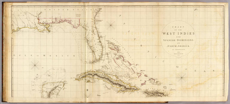
Arrowsmith, Aaron
Full Title
Chart of the West Indies and Spanish Dominions in North America. (Sheet 1). By A. Arrowsmith. 1803. Hydrographer to H.R.H. the Prince of Wales. Additions to 1810. London, Published June 1st, 1803 by A. Arrowsmith, 10 Soho Square. Jones, Smith & Co. sc., Beaufort Buildgs., Strand.
List No
5699.015
Note
Engraved map. Outline hand col. Relief shown by hachures; depths by soundings. Sheet 1 of 2. Shows settlements, roads, rivers, etc. Includes descriptive notes. Printed on 2 sheets, joined together.
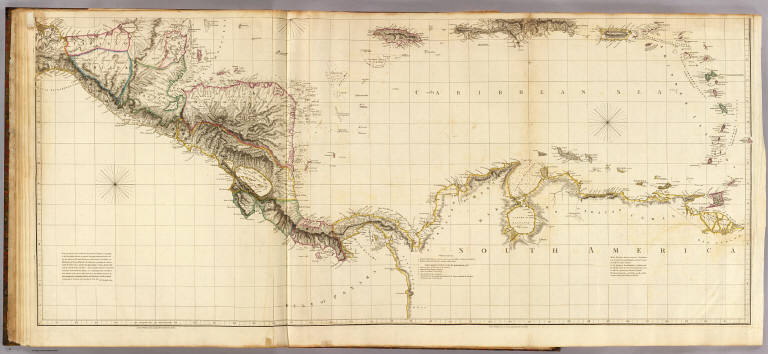
Author
Arrowsmith, Aaron
Full Title
(Chart of the West Indies and Spanish Dominions in North America. Sheet 2. By A. Arrowsmith. 1803. Hydrographer to H.R.H. the Prince of Wales. Additions to 1810). London, Published June 1st, 1803 by A. Arrowsmith, 10 Soho Square. (Jones, Smith & Co. sc., Beaufort Buildgs., Strand)
List No
5699.016
Note
Engraved map. Outline hand col. Relief shown by hachures; depths by soundings. Sheet 2 of 2. Shows settlements, roads, rivers, etc. Includes descriptive notes. Printed on 2 sheets, joined together.
Author
Arrowsmith, Aaron
Full Title
Outlines of the physical and political divisions of South America: (Sheet 1) delineated by A. Arrowsmith, partly from scarce and original documents, published before the year 1806 but principally from manuscript maps & surveys made between the years 1771 and 1806, corrected from accurate astronomical observations to 1810. London, Published 4th January 1811 by A. Arrowsmith, No. 10 Soho Square, Hydrographer to H.R. H. the Prince of Wales. Additions to 1814, 1817. Engraved by Edwd. Jones.
List No
5699.018
Note
Engraved map. Outline hand col. Relief shown by hachures. Sheet 1 of 6. Shows settlements, roads, rivers, Indian tribes, etc.
Author
Arrowsmith, Aaron
Full Title
(Outlines of the physical and political divisions of South America: Sheet 2. Delineated by A. Arrowsmith, partly from scarce and original documents, published before the year 1806 but principally from manuscript maps & surveys made between the years 1771 and 1806, corrected from accurate astronomical observations to 1810) London, Published 4th January 1811 by A. Arrowsmith, No. 10 Soho Square, (Hydrographer to H.R. H. the Prince of Wales. Additions to 1814, 1817. Engraved by Edwd. Jones)
List No
5699.019
Note
Engraved map. Outline hand col. Relief shown by hachures. Sheet 2 of 6. Shows settlements, roads, rivers, Indian tribes, etc.
Author
Arrowsmith, Aaron
Full Title
(Outlines of the physical and political divisions of South America: Sheet 3. Delineated by A. Arrowsmith, partly from scarce and original documents, published before the year 1806 but principally from manuscript maps & surveys made between the years 1771 and 1806, corrected from accurate astronomical observations to 1810) London, Published 4th January 1811 by A. Arrowsmith, No. 10 Soho Square, (Hydrographer to H.R. H. the Prince of Wales. Additions to 1814, 1817. Engraved by Edwd. Jones)
List No
5699.020
Note
Engraved map. Outline hand col. Relief shown by hachures. Sheet 3 of 6. Shows settlements, roads, rivers, Indian tribes, etc.
Author
Arrowsmith, Aaron
Full Title
(Outlines of the physical and political divisions of South America: Sheet 4. Delineated by A. Arrowsmith, partly from scarce and original documents, published before the year 1806 but principally from manuscript maps & surveys made between the years 1771 and 1806, corrected from accurate astronomical observations to 1810) London, Published 4th January 1811 by A. Arrowsmith, No. 10 Soho Square, (Hydrographer to H.R. H. the Prince of Wales. Additions to 1814, 1817. Engraved by Edwd. Jones)
List No
5699.021
Note
Engraved map. Outline hand col. Relief shown by hachures. Sheet 4 of 6. Shows settlements, roads, rivers, Indian tribes, etc.
Author
Arrowsmith, Aaron
Full Title
(Outlines of the physical and political divisions of South America: Sheet 5. Delineated by A. Arrowsmith, partly from scarce and original documents, published before the year 1806 but principally from manuscript maps & surveys made between the years 1771 and 1806, corrected from accurate astronomical observations to 1810) (with Inset map of the Orinoco and Meta rivers). London, Published 4th January 1811 by A. Arrowsmith, No. 10 Soho Square, (Hydrographer to H.R. H. the Prince of Wales. Additions to 1814, 1817. Engraved by Edwd. Jones)
List No
5699.022
Note
Engraved map. Outline hand col. Relief shown by hachures. Sheet 5 of 6. Shows settlements, roads, rivers, Indian tribes, etc. Scale of inset (ca. 1:118,000)
Author
Arrowsmith, Aaron
Full Title
(Outlines of the physical and political divisions of South America: Sheet 6. Delineated by A. Arrowsmith, partly from scarce and original documents, published before the year 1806 but principally from manuscript maps & surveys made between the years 1771 and 1806, corrected from accurate astronomical observations to 1810). London, Published 4th January 1811 by A. Arrowsmith, No. 10 Soho Square, (Hydrographer to H.R. H. the Prince of Wales. Additions to 1814, 1817. Engraved by Edwd. Jones)
List No
5699.023
Note
Engraved map. Outline hand col. Relief shown by hachures. Sheet 6 of 6. Shows settlements, roads, rivers, Indian tribes, etc. Patagonia, Tierra del Fuego and the Falkland Islands are in inset map.
1-19 of 19
|