|
REFINE
Browse All : Pocket Map by Tanner, Henry S.
1-46 of 46
Author
Tanner, Henry S.
Full Title
(Covers to) Map Of The States Of Maine, New Hampshire, Vermont, Massachusetts, Connecticut & Rhode Island. By H.S. Tanner 1847. Engraved & Published by H.S. Tanner, Philadelphia.
List No
0985.001
Note
Adds Railroads and Canals to 1820 Atlas map. Covers are a dark brown cloth 15.5x10 stamped with "Tanner's Travelling Map Of New England" in gilt. Counties in Maine are changed, as well as the Maine boundary with Canada, a line of mountains added north of Maine; list of canals and railroads upper right. Full color by county.
Author
Tanner, Henry S.
Full Title
Map Of The States Of Maine, New Hampshire, Vermont, Massachusetts, Connecticut & Rhode Island. By H.S. Tanner 1847. Engraved & Published by H.S. Tanner, Philadelphia.
List No
0985.002
Note
Adds Railroads and Canals to 1820 Atlas map. Covers are a dark brown cloth 15.5x10 stamped with "Tanner's Travelling Map Of New England" in gilt. Counties in Maine are changed, as well as the Maine boundary with Canada, a line of mountains added north of Maine; list of canals and railroads upper right. Full color by county. Prime meridians are Washington D.C. and Greenwich.
Author
Tanner, Henry S.
Full Title
(Covers to) A Map Of The United States Of Mexico, As organized and defined by the several Acts of the Congress of that Republic. Constructed from a great variety of Printed and Manuscript Documents by H.S. Tanner. Third Edition, 1846. Published by H.S. Tanner. Entered ... 1846, by H.S. Tanner ... New York. (inset) Map Of The Roads &c. From Vera Cruz & Alvarado To Mexico.
List No
2822A
Author
Tanner, Henry S.
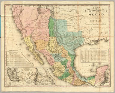
Full Title
A Map Of The United States Of Mexico, As organized and defined by the several Acts of the Congress of that Republic. Constructed from a great variety of Printed and Manuscript Documents by H.S. Tanner. Third Edition, 1846. Published by H.S. Tanner. Entered ... 1846, by H.S. Tanner ... New York. (inset) Map Of The Roads &c. From Vera Cruz & Alvarado To Mexico.
List No
2822.001
Note
3rd edition. Martin shows 10 issues 1825-47. 1st edition was 1825 (see W.H. copy). The 1826 edition of this map (see our copy) was the base for the White, Gallaher & White "Mapa de los Estados Unidos de Mejico" of 1828, which was then copied by Disturnell in 1846 (see our copy). Originally, Tanner copied this map from the southwestern portion of his Map of North America. This 1846 edition has updated the western cartography to include Fremont's route and topography in California and the Rocky Mountains. Interestingly, Lake Tahoe is labeled Flag Lake, a name we have never seen before. The 1826 edition of this map established the more northerly boundary of New Mexico and Mexico that White Gallaher & White copied and was ultimately used by Disturnell in his map, and affected the treaty negotiations (see Martin). See our 1847, fifth edition, #5158. Full color map, folded into dark brown cloth covers 15x9.5 with "Tanner's Travelling Map Of Mexico" stamped in gilt.
Author
Tanner, Henry S.
Full Title
(Covers to) The Traveller's Guide Or Map Of The Roads, Canals & Rail Roads of the United States With the distances from place to place. By H.S. Tanner 1846. Published by H.S Tanner, 144 Chestnut St. Philadelphia. Entered ... 1844, by H.S. Tanner ... Pennsylvania. (with 11 inset maps).
List No
2985.001
Note
Separate issue of the map normally found with the guide. Inset maps show the environs of Albany Saratoga, Niagara Falls, Quebec, Providence, Boston, Richmond, New York, Charleston, Baltimore and Washington, Washington D.C., and Philadelphia. Full color by state. Brown cloth covers 13.5x8.5 are stamped "U. States" in gold.
Author
Tanner, Henry S.
Full Title
The Traveller's Guide Or Map Of The Roads, Canals & Rail Roads of the United States With the distances from place to place. By H.S. Tanner 1846. Published by H.S Tanner, 144 Chestnut St. Philadelphia. Entered ... 1844, by H.S. Tanner ... Pennsylvania. (with 11 inset maps).
List No
2985.002
Note
Separate issue of the map normally found with the guide. Inset maps show the environs of Albany Saratoga, Niagara Falls, Quebec, Providence, Boston, Richmond, New York, Charleston, Baltimore and Washington, Washington D.C., and Philadelphia. Full color by state. Brown cloth covers 13.5x8.5 are stamped "U. States" in gold.
Author
Tanner, Henry S.
Full Title
(Covers to) A Map Of Philadelphia And Adjacent Country. Published by H.S. Tanner, Philadelphia, 1826.
List No
3014.001
Note
The non geological version of the Troost map in pocket form. Tanner published this map in two forms: colored geologically to accompany Tanner's publication of Gerard Troost's Geological Survey of the Environs of Philadelphia, 1826, and, (eliminating "designed to illustrate the geological survey made by G. Troost" from the title and the geological coloring), as a map of Philadelphia and the adjacent country. Marcou says the Troost book and map are rare. This pocket map version is not in Phillips and is quite scarce. See Tanner 1829 Memoir catalogue, No. 50 and 51 for a listing of this map in both forms. Covers are a red leather 10.5x6.5 cm. and stamped with "Philadelphia." in gilt.
Author
Tanner, Henry S.
Full Title
A Map Of Philadelphia And Adjacent Country. Published by H.S. Tanner, Philadelphia, 1826.
List No
3014.002
Note
The non geological version of the Troost map in pocket form. Tanner published this map in two forms: colored geologically to accompany Tanner's publication of Gerard Troost's Geological Survey of the Environs of Philadelphia, 1826, and, (eliminating "designed to illustrate the geological survey made by G. Troost" from the title and the geological coloring), as a map of Philadelphia and the adjacent country. Marcou says the Troost book and map are rare. This pocket map version is not in Phillips and is quite scarce. See Tanner 1829 Memoir catalogue, No. 50 and 51 for a listing of this map in both forms. Covers are a red leather 10.5x6.5 cm. and stamped with "Philadelphia." in gilt.
Author
Tanner, Henry S.
Full Title
(Covers to) Map Of Pennsylvania And New Jersey. By H.S. Tanner. 1830. Published by H.S. Tanner, Philadelphia. Entered ... 20th day of August 1823, by H.S. Tanner ... Pennsylvania. Engraved by H.S. Tanner & Assistants.
List No
3061.001
Note
Early edition of Canal map of 1834, on the 1823 base map. See No. 19 in Tanner's Memoir catalogue of 1829 - this is a listing of this map (we assume) published in 1829 or earlier. Later, it became the map used in Tanner's book of 1834 on Pennsylvania and New Jersey Canals and Railroads. This map is the same as the atlas map of 1823, except the existing and proposed canals and railroads are shown in color and many are delineated that do not appear on the atlas map. Outline color by state. Map is folded into red leather covers 15x8.5 with "Pennsylvania Canals" stamped in gilt. Prime meridians are Washington D.C. and Greenwich. Relief shown by hachures.
Author
Tanner, Henry S.
Full Title
Map Of Pennsylvania And New Jersey. By H.S. Tanner. 1830. Published by H.S. Tanner, Philadelphia. Entered ... 20th day of August 1823, by H.S. Tanner ... Pennsylvania. Engraved by H.S. Tanner & Assistants.
List No
3061.002
Note
Early edition of Canal map of 1834, on the 1823 base map. See No. 19 in Tanner's Memoir catalogue of 1829 - this is a listing of this map (we assume) published in 1829 or earlier. Later, it became the map used in Tanner's book of 1834 on Pennsylvania and New Jersey Canals and Railroads. This map is the same as the atlas map of 1823, except the existing and proposed canals and railroads are shown in color and many are delineated that do not appear on the atlas map. Outline color by state. Map is folded into red leather covers 15x8.5 with "Pennsylvania Canals" stamped in gilt. Prime meridians are Washington D.C. and Greenwich. Relief shown by hachures.
Author
Tanner, Henry S.
Full Title
(Covers to) New Hampshire & Vermont: By H.S. Tanner. Published by H.S. Tanner Philadelphia. Tanner & Disturnell, 124 Broadway, New York. Entered ... 1840, by H.S. Tannerr ... Pennsylvania. Engraved by J. & W.W. Warr. (above the neat line) Tanner's Universal Atlas.
List No
3115.001
Note
Pocket map issue of 1842 Universal Atlas map. Ms label on the cover suggests the map may have been published without a title on the cover. Full color by county. Map is folded into dark brown cloth covers 12.5x8, label has written in pen "N. Hamp. & Vert" in ink. Prime meridian is Washington D.C. Relief shown by hachures.
Author
Tanner, Henry S.
Full Title
New Hampshire & Vermont: By H.S. Tanner. Published by H.S. Tanner Philadelphia. Tanner & Disturnell, 124 Broadway, New York. Entered ... 1840, by H.S. Tannerr ... Pennsylvania. Engraved by J. & W.W. Warr. (above the neat line) Tanner's Universal Atlas.
List No
3115.002
Note
Pocket map issue of 1842 Universal Atlas map. Ms label on the cover suggests the map may have been published without a title on the cover. Full color by county. Map is folded into dark brown cloth covers 12.5x8, label has written in pen "N. Hamp. & Vert" in ink. Prime meridian is Washington D.C. Relief shown by hachures.
Author
Tanner, Henry S.
Full Title
A Map Of The Canals & Rail Roads Of Pennsylvania And New Jersey And The Adjoining States. By H.S. Tanner. Published by H.S. Tanner ... Entered ... 1833, by H.S. Tanner ... Pennsylvania. Engraved by H.S. Tanner & Assistants. (with) A Brief Description Of The Canals And Rail Roads Of Pennsylvania And New Jersey, Comprehending Notices Of All The Most Important Works Of Internal Improvements, In Those States. By H.S. Tanner. Philadelphia: Published By The Author, November, 1834. (on verso) Entered ... 1834, by H.S. Tanner ... Pennsylvania. Joseph & William Kite, Printers.
List No
3942.003
Note
One of the earliest canal and railroads guides of these two states. The map is based on the 1823 atlas map and the later 1830 edition published separately (see our copy). Full color. Map and guide are in brown leather covers with "Canals & Railroads Of Penna. & Jersey." stamped in gold on the front. Prime meridians are Washington D.C. and Greenwich. Relief shown by hachures.
Author
Tanner, Henry S.
Full Title
(Covers to) Map of California New Mexico Texas &c. Published by H.S. Tanner No. 156 Fulton St. New York 1849.
List No
4073A
Author
Tanner, Henry S.
Full Title
Map of California New Mexico Texas &c. Published by H.S. Tanner No. 156 Fulton St. New York 1849.
List No
4073.001
Note
This is taken from Tanner's Map of the United States of Mexico, with the addition of the California Gold Regions colored in yellow, and an added inset map of "United States, Mexico &c. Shewing the Routes from N. York to St. Francisco by Land & Water." The map has been updated to show Fremont's route across the Great Basin and the "Boundary of 1848" with Mexico. The 14x9 cover entitled "Tanner's Travelling Map of California & c has on the inside front a "Table of Routes from New-York to California, with the Modes of Conveyance, Distances, Time and Fares." This is a very late map for Tanner, still printed from engraved plates (although the impression looks a bit tired), in the next to last year of his publishing career. He died in Brooklyn in 1858.
Author
Tanner, Henry S.
Full Title
(Covers to) Ohio And Indiana. By H.S. Tanner. 1827. Engraved & Published by H.S. Tanner, Philadelphia. Entered ... 24th day of May 1819, by Tanner, Vallance, Kearny & Co. ... Pennsylvania.
List No
4541.001
Note
A pocket map version printed on thin paper and folded into red leather covers. There are additional counties in northern Indiana when compared to the 1826 case map edition. Outline color by county. Folded into untitled red leather covers 15x8.5 with a border pattern stamped in gilt. Prime meridians are Washington D.C. and Greenwich.
Author
Tanner, Henry S.
Full Title
Ohio And Indiana. By H.S. Tanner. 1827. Engraved & Published by H.S. Tanner, Philadelphia. Entered ... 24th day of May 1819, by Tanner, Vallance, Kearny & Co. ... Pennsylvania.
List No
4541.002
Note
A pocket map version printed on thin paper and folded into red leather covers. There are additional counties in northern Indiana when compared to the 1826 case map edition. Outline color by county. Folded into untitled red leather covers 15x8.5 with a border pattern stamped in gilt. Prime meridians are Washington D.C. and Greenwich.
Author
Tanner, Henry S.
Full Title
(Covers to) A Map Of The Canals & Rail Roads Of Pennsylvania And New Jersey And The Adjoining States. By H.S. Tanner. Published by H.S. Tanner, Philadelphia ... Entered ... 1839, by H.S. Tanner ... Pennsylvania. Engraved by H.S. Tanner & Assistants.
List No
4551.001
Note
The copyright date has been changed to 1839. Phillips shows the 1839 edition appearing in the 1839 edition of the New American Atlas. Most of the additions and changes involve railroads; the canal development is about the same as the 1834 edition. The dark brown cloth covers 14.5x9.5 have printed in gilt "Tanner's Travelling Map Of Penna. & N. Jersey With The Roads, Canals, Railroads, Counties .& 1840." Full color by county. Prime meridians are Washington D.C. and Greenwich. Relief shown by hachures.
Author
Tanner, Henry S.
Full Title
A Map Of The Canals & Rail Roads Of Pennsylvania And New Jersey And The Adjoining States. By H.S. Tanner. Published by H.S. Tanner, Philadelphia ... Entered ... 1839, by H.S. Tanner ... Pennsylvania. Engraved by H.S. Tanner & Assistants.
List No
4551.002
Note
The copyright date has been changed to 1839. Phillips shows the 1839 edition appearing in the 1839 edition of the New American Atlas. Most of the additions and changes involve railroads; the canal development is about the same as the 1834 edition. The dark brown cloth covers 14.5x9.5 have printed in gilt "Tanner's Travelling Map Of Penna. & N. Jersey With The Roads, Canals, Railroads, Counties .& 1840." Full color by county. Prime meridians are Washington D.C. and Greenwich. Relief shown by hachures.
Author
Tanner, Henry S.
Full Title
(Covers to) Mexico & Guatemala: By H.S. Tanner. (with) Guatemala. (with) Valley of Mexico. Published by C.S. Williams, N.E. corner of Market & 7th Street, Philadelphia, 1846. Entered ... 1834, by H.S. Tanner ... Pennsylvania.
List No
4800A
Note
Full color by state. Hand colored. Relief shown by hachures. Prime meridian: Washington. This is plate 36 from Tanner's Universal Atlas of 1846, here issued as a separate pocket map by C.S. Williams of Philadelphia. Full color. Folded into stamped dark green leather covers 12.5x8 with title "Mexico." in gold.
Author
Tanner, Henry S.
Full Title
Mexico & Guatemala: By H.S. Tanner. (with) Guatemala. (with) Valley of Mexico. Published by C.S. Williams, N.E. corner of Market & 7th Street, Philadelphia, 1846. Entered ... 1834, by H.S. Tanner ... Pennsylvania.
List No
4800.001
Note
Full color by state. Hand colored. Relief shown by hachures. Prime meridian: Washington. This is plate 36 from Tanner's Universal Atlas of 1846, here issued as a separate pocket map by C.S. Williams of Philadelphia. Full color. Folded into stamped dark green leather covers 12.5x8 with title "Mexico." in gold.
Author
Tanner, Henry S.
Full Title
(Covers to) Illinois And Missouri. By H.S. Tanner. 1836. Published by H.S. Tanner, Philadelphia. Entered ... 1836, by H.S. Tanner ... Pennsylvania. Engraved by H.S. Tanner & Assistants.
List No
4803.001
Note
This is a very late edition of this map. The latest American Atlas edition we have seen is 1839. In the upper right corner, the map has been extended beyond the neat line to show the developing areas of southern Wisconsin, around Mineral Point. Many new counties have been added in Missouri and Illinois. The copyright date has been changed to 1836. The southwestern shore of Lake Michigan has been completely redrawn. Proposed railroads are prominently displayed crisscrossing Illinois - the first such depictions on any editions of this map. Full color by county, folded into black leather covers 15x8.5 with "Illinois & Missouri." stamped in gold. Prime meridian is Greenwich.
Author
Tanner, Henry S.
Full Title
Illinois And Missouri. By H.S. Tanner. 1836. Published by H.S. Tanner, Philadelphia. Entered ... 1836, by H.S. Tanner ... Pennsylvania. Engraved by H.S. Tanner & Assistants.
List No
4803.002
Note
This is a very late edition of this map. The latest American Atlas edition we have seen is 1839. In the upper right corner, the map has been extended beyond the neat line to show the developing areas of southern Wisconsin, around Mineral Point. Many new counties have been added in Missouri and Illinois. The copyright date has been changed to 1836. The southwestern shore of Lake Michigan has been completely redrawn. Proposed railroads are prominently displayed crisscrossing Illinois - the first such depictions on any editions of this map. Full color by county, folded into black leather covers 15x8.5 with "Illinois & Missouri." stamped in gold. Prime meridian is Greenwich.
Author
Tanner, Henry S.
Full Title
(Covers to) A New Map Of Pennsylvania with its Canals, Rail-Roads & Distances from Place to Place along the Stage Roads. by H.S. Tanner. Published by H.S. Tanner, No. 144 Chestnut St. Philadelphia. Entered ... 1833, by H.S. Tanner ... Pennsylvania. Engraved by W. Brose, Philadelphia. (above the neat line) Tanner's Universal Atlas. (inset) Profile Of The Pennsylvania Canal. Columbia Rail Road.
List No
4917.001
Note
The same map appears in Tanner's Universal Atlas of 1833-35; all of the U.S.atlas maps were issued as pocket maps for "Travellers." Full color by county, folded into reddish brown leather covers 10.5x6.5 with "Pennsylvania Traveller." embossed in gold. Prime meridian is Washington D.C. Relief shown by hachures.
Author
Tanner, Henry S.
Full Title
A New Map Of Pennsylvania with its Canals, Rail-Roads & Distances from Place to Place along the Stage Roads. by H.S. Tanner. Published by H.S. Tanner, No. 144 Chestnut St. Philadelphia. Entered ... 1833, by H.S. Tanner ... Pennsylvania. Engraved by W. Brose, Philadelphia. (above the neat line) Tanner's Universal Atlas. (inset) Profile Of The Pennsylvania Canal. Columbia Rail Road.
List No
4917.002
Note
The same map appears in Tanner's Universal Atlas of 1833-35; all of the U.S.atlas maps were issued as pocket maps for "Travellers." Full color by county, folded into reddish brown leather covers 10.5x6.5 with "Pennsylvania Traveller." embossed in gold. Prime meridian is Washington D.C. Relief shown by hachures.
Author
Tanner, Henry S.
Full Title
(Covers to) Map Of North & South Carolina. By H.S. Tanner. 1840. Published by H.S. Tanner, Philadelphia. Engraved by H.S. Tanner & Assistants. (above the neat line) American Atlas.
List No
5026.001
Note
On the cover: Tanner's Travelling Map of N. & S. Carolina With The Roads, Canals, Railroads, Counties, &c. 1840. First issued with the American Atlas of 1823. Changes from the 1827 issue in the American Atlas of (1833) include the appearance of two new counties in western North Carolina (Macon and Yancy) and the addition of several railroads in North and South Carolina. The copyright notice has been removed from the lower left corner. Full color by county, map is folded into dark brown cloth covers 15x9.5 titled "Tanner's Travelling Map Of N.&S. Carolina With The Roads. Canals. Railroads. Counties.&c 1840" stamped in gold. Prime meridians are Washington D.C. and Greenwich. Relief shown by hachures.
Author
Tanner, Henry S.
Full Title
Map Of North & South Carolina. By H.S. Tanner. 1840. Published by H.S. Tanner, Philadelphia. Engraved by H.S. Tanner & Assistants. (above the neat line) American Atlas.
List No
5026.002
Note
On the cover: Tanner's Travelling Map of N. & S. Carolina With The Roads, Canals, Railroads, Counties, &c. 1840. First issued with the American Atlas of 1823. Changes from the 1827 issue in the American Atlas of (1833) include the appearance of two new counties in western North Carolina (Macon and Yancy) and the addition of several railroads in North and South Carolina. The copyright notice has been removed from the lower left corner. Full color by county, map is folded into dark brown cloth covers 15x9.5 titled "Tanner's Travelling Map Of N.&S. Carolina With The Roads. Canals. Railroads. Counties.&c 1840" stamped in gold. Prime meridians are Washington D.C. and Greenwich. Relief shown by hachures.
Author
Tanner, Henry S.
Full Title
(Covers to) New York. By H.S. Tanner. 1850. Published by H.S. Tanner, Philadelphia. & T.R. Tanner, New York.
List No
5042.001
Note
This is the latest dated imprint we have found for Henry Tanner. This pocket map is a reissue of the American Atlas map of New York, updated with the addition of railroads built and planned, and the new counties of Wyoming and Chemung. A table of "Reference to the Canals & Railroads" is added at the top of the map. The dark brown cloth covers 15.5x9.5 are stamped "Tanner's Travelling Map Of New York" in gold. Full color by county. Prime meridians are Washington D.C. and Greenwich. Relief shown by hachures.
Author
Tanner, Henry S.
Full Title
New York. By H.S. Tanner. 1850. Published by H.S. Tanner, Philadelphia. & T.R. Tanner, New York.
List No
5042.002
Note
This is the latest dated imprint we have found for Henry Tanner. This pocket map is a reissue of the American Atlas map of New York, updated with the addition of railroads built and planned, and the new counties of Wyoming and Chemung. A table of "Reference to the Canals & Railroads" is added at the top of the map. The dark brown cloth covers 15.5x9.5 are stamped "Tanner's Travelling Map Of New York" in gold. Full color by county. Prime meridians are Washington D.C. and Greenwich. Relief shown by hachures.
Author
Tanner, Henry S.
Full Title
(Covers to) City Of New-York. Philadelphia Published by H.S. Tanner. Entered ... 1835 by Henry S. Tanner ... Pennsylvania. (above the neat line) Tanner's Universal Atlas.
List No
5129.001
Note
From the Universal Atlas, here in pocket map form. The date is from the copyright date, but it could be later as the map was essentially unchanged until the 1844 atlas edition. Full color. Folded into very dark green leather covers 11x6.5 with "City Of New York." stamped in gilt.
Author
Tanner, Henry S.
Full Title
City Of New-York. Philadelphia Published by H.S. Tanner. Entered ... 1835 by Henry S. Tanner ... Pennsylvania. (above the neat line) Tanner's Universal Atlas.
List No
5129.002
Note
From the Universal Atlas, here in pocket map form. The date is from the copyright date, but it could be later as the map was essentially unchanged until the 1844 atlas edition. Full color. Folded into very dark green leather covers 11x6.5 with "City Of New York." stamped in gilt.
Author
Tanner, Henry S.
Full Title
(Covers to) Map Of Pennsylvania And New Jersey. By H.S. Tanner. 1827. Published by H.S. Tanner, Philadelphia. Entered ... 1823, by H.S. Tanner ... Pennsylvania. Engraved by H.S. Tanner & Assistants.
List No
5152.001
Note
This is the American Atlas map of Pennsylvania and New Jersey, in transition to becoming the later more full blown canal map of 1830 (see our #3061). Several new canals are shown that do not appear on the atlas map of 1825: the Ohio Canal, Pennsylvania Canal, Union Canal, Hudson & Delaware Canal; completed and contemplated canals are shown in the Explanation, for the first time. Tanner was very interested in showing the growth of "internal improvements" in the states and the expansion of the canals of Pennsylvania in the period from 1825 to 1845 was shown progressively on a series of his maps (see also our #3942, 4551, and 4862 (1833 issue of the American Atlas with the Pennsylvania Canal map dated 1833). Map has outline color by county, and is folded into untitled red leather covers 15x8.5 with a border pattern stamped in gilt. Prime meridians are Washington D.C. and greenwich. Relief shown by hachures.
Author
Tanner, Henry S.
Full Title
Map Of Pennsylvania And New Jersey. By H.S. Tanner. 1827. Published by H.S. Tanner, Philadelphia. Entered ... 1823, by H.S. Tanner ... Pennsylvania. Engraved by H.S. Tanner & Assistants.
List No
5152.002
Note
This is the American Atlas map of Pennsylvania and New Jersey, in transition to becoming the later more full blown canal map of 1830 (see our #3061). Several new canals are shown that do not appear on the atlas map of 1825: the Ohio Canal, Pennsylvania Canal, Union Canal, Hudson & Delaware Canal; completed and contemplated canals are shown in the Explanation, for the first time. Tanner was very interested in showing the growth of "internal improvements" in the states and the expansion of the canals of Pennsylvania in the period from 1825 to 1845 was shown progressively on a series of his maps (see also our #3942, 4551, and 4862 (1833 issue of the American Atlas with the Pennsylvania Canal map dated 1833). Map has outline color by county, and is folded into untitled red leather covers 15x8.5 with a border pattern stamped in gilt. Prime meridians are Washington D.C. and greenwich. Relief shown by hachures.
Author
Tanner, Henry S.
Full Title
(Covers to) New York. By H.S. Tanner. 1827. Engraved & Published by H.S. Tanner, Philadelphia. Entered ... 12th day of May 1819, by Tanner, Vallance, Kearny & Co. ... Pennsylvania.
List No
5157.001
Note
This issue is later than any of the five atlas versions of this map in our Tanner American Atlases, although the changes are not momentous: it adds the Champlain Canal and the Hudson & Delaware Canal. Outline color by county. Folded into untitled red leather covers 15x8.5 with decorative border stamped in gilt. Prime meridians are Washington d.C. and Greenwich. Relief shown by hachures.
Author
Tanner, Henry S.
Full Title
New York. By H.S. Tanner. 1827. Engraved & Published by H.S. Tanner, Philadelphia. Entered ... 12th day of May 1819, by Tanner, Vallance, Kearny & Co. ... Pennsylvania.
List No
5157.002
Note
This issue is later than any of the five atlas versions of this map in our Tanner American Atlases, although the changes are not momentous: it adds the Champlain Canal and the Hudson & Delaware Canal. Outline color by county. Folded into untitled red leather covers 15x8.5 with decorative border stamped in gilt. Prime meridians are Washington d.C. and Greenwich. Relief shown by hachures.
Author
Tanner, Henry S.
Full Title
(Covers to) A Map Of The United States Of Mexico, As organized and defined by the several Acts of the Congress of that Republic. Constructed from a great variety of Printed and Manuscript Documents by H.S. Tanner. Fifth edition, 1847. Published by H.S. Tanner. Entered ... 1846, by H.S. Tanner ... New York. (inset) Map Of The Roads &c. From Vera Cruz & Alvarado To Mexico. (inset) Harbor Of Vera Cruz.
List No
5158A
Author
Tanner, Henry S.
Full Title
A Map Of The United States Of Mexico, As organized and defined by the several Acts of the Congress of that Republic. Constructed from a great variety of Printed and Manuscript Documents by H.S. Tanner. Fifth edition, 1847. Published by H.S. Tanner. Entered ... 1846, by H.S. Tanner ... New York. (inset) Map Of The Roads &c. From Vera Cruz & Alvarado To Mexico. (inset) Harbor Of Vera Cruz.
List No
5158.001
Note
This edition adds an inset map of "Harbor of Vera Cruz," and "Dates of Battles" listing seven battles of the Mexican War beginning with Palo Alto May 8, 1846 and ending with Vera Cruz, March 22 to 27, 1847. Gen Kearny's route from Ft. Leavenworth to Santa Fe is shown and labeled, along with other routes of battle (unlabeled) running from Texas south to La Puebla, Mexico. This is the last edition published by Tanner, according to Martin. It is the best edition in terms of showing the events of the Mexican War. See our 1846, third edition, #2822. Folded into dark brown cloth covers 15.5x10 with "Tanner's Travelling Map of Mexico" stamped in gold. Full color.
Author
Tanner, Henry S.
Full Title
(Covers to) A Map Of The United States Of Mexico, As organized and defined by the several Acts of the Congress of that Republic. Constructed from a great variety of Printed and Manuscript Documents by H.S. Tanner. 1826. Entered ... 10th day of June 1825, by H.S. Tanner ... (inset) Map Of The Roads &c. From Vera Cruz & Alvarado To Mexico.
List No
5176A
Author
Tanner, Henry S.
Full Title
A Map Of The United States Of Mexico, As organized and defined by the several Acts of the Congress of that Republic. Constructed from a great variety of Printed and Manuscript Documents by H.S. Tanner. 1826. Entered ... 10th day of June 1825, by H.S. Tanner ... (inset) Map Of The Roads &c. From Vera Cruz & Alvarado To Mexico.
List No
5176.001
Note
This is the second edition and the source of the White Gallaher and White map of Mexico issued in 1828, which was reissued by Disturnell in 1846. See our 1846 and 1847 issues of this Tanner map. This copy, although having several areas of loss, is significant in being the personal copy of Anthony Dey, one of the three principals of the Galveston Bay and Texas Land Company. It is not signed by Dey, but was found with many of his personal papers including documents relating to the Company (see our #5177). On the map, the lands owned by the Company are outlined in manuscript. The Company controled a vast area of land in southeastern Texas and was one of the earliest to offer lands for sale to colonists - several of its promotional materials are listed in Streeter Texas. Outline color by state. Map is folded into red leather covers 15x8.5 stamped with "Mexico." in gold.
Author
Tanner, Henry S.
Full Title
(Covers to) Kentucky And Tennessee. By H.S. Tanner. No. 201 Broadway, N. York, 1850. Engraved by H.S. Tanner & Assistants.
List No
5230.001
Note
This is the last year of publication for Tanner, and the latest issue of this map that we know of. Full color map folded into dark brown cloth covers 13.5x8.5 stamped in gold "Kenty. & Tene." Prime meridians are Washington D.C. and Greenwich. Relief shown by hachures.
Author
Tanner, Henry S.
Full Title
Kentucky And Tennessee. By H.S. Tanner. No. 201 Broadway, N. York, 1850. Engraved by H.S. Tanner & Assistants.
List No
5230.002
Note
This is the last year of publication for Tanner, and the latest issue of this map that we know of. Full color map folded into dark brown cloth covers 13.5x8.5 stamped in gold "Kenty. & Tene." Prime meridians are Washington D.C. and Greenwich. Relief shown by hachures.
Author
Tanner, Henry S.
Full Title
(Covers to) Massachusetts And Rhode Island: By H.S. Tanner. Published by C.S. Williams ... Philadelphia. 1846. Entered ... in the year 1841, by H.S. Tanner in the ... Eastern District of Pennsylvania. (inset map) Boston.
List No
5367.001
Note
This is an earlier version, in pocket map form, of the map of the same title that appeared in the six map folio issued by S. Augustus Mitchell in 1846 (see our #536). Mitchell's version adds his publisher imprint under Tanner's name in the title and does not list C.S. Williams as publisher under the neat line. Map is printed color in blue and red. Folded into brown leather covers 13x8 with "Massachusetts And Rhode Island" stamped in gilt. Prime meridian is Washington D.C.
Author
Tanner, Henry S.
Full Title
Massachusetts And Rhode Island: By H.S. Tanner. Published by C.S. Williams ... Philadelphia. 1846. Entered ... in the year 1841, by H.S. Tanner in the ... Eastern District of Pennsylvania. (inset map) Boston.
List No
5367.002
Note
This is an earlier version, in pocket map form, of the map of the same title that appeared in the six map folio issued by S. Augustus Mitchell in 1846 (see our #536). Mitchell's version adds his publisher imprint under Tanner's name in the title and does not list C.S. Williams as publisher under the neat line. Map is printed color in blue and red. Folded into brown leather covers 13x8 with "Massachusetts And Rhode Island" stamped in gilt. Prime meridian is Washington D.C.
Author
Tanner, Henry S.
Full Title
Illinois And Missouri. By H.S. Tanner. 1840. Published by H.S. Tanner, Philadelphia. Entered ... 1839, by H.S. Tanner ... Pennsylvania. Engraved by H.S. Tanner & Assistants.
List No
5538.000
Note
This is a very late edition of this map. The latest American Atlas edition we have seen is 1839. State one of the map is from 1823; state two is dated 1825 below the title, with an 1823 copyright statement at bottom left; state three has an 1833 date on both the map and the copyright; and this, state four, has an 1840 date on the map with an 1839 copyright statement at the bottom. In the upper right corner, the map has been extended beyond the neat line to show the developing areas of southern Wisconsin, around Mineral Point. Many new counties have been added in Missouri and Illinois. Proposed railroads are prominently displayed crisscrossing Illinois. Full color by county with the pocket map covers missing.
Author
[Mills, Robert, Tanner, Henry S.]
Full Title
(Covers to) Marlborough District, South Carolina. Improved for Mills' Atlas, 1825. Engd. by H.S. Tanner & Assistants.
List No
5542A
Author
[Mills, Robert, Tanner, Henry S.]
Full Title
Marlborough District, South Carolina. Improved for Mills' Atlas, 1825. Engd. by H.S. Tanner & Assistants.
List No
5542.001
Note
Rare pocket map with original black leather covers, with "Marlborough District" in gold on the front. Marlborough county is in the northeastern section of the state, abutting the North Carolina border. The same map was included in Mills' Atlas of 1825 (see our #2792). With light red tinting across the county (not found in the state atlas). Map shows stores, homes, mills, roads, vegetation, churches, and rivers.
1-46 of 46
|