|
REFINE
Browse All : Images by Stein, Christ. Gottfr. Dan. from 1854
1-46 of 46
Author
[Stein, Christ. Gottfr. Dan., Wagner, Karl Theodor]
Full Title
(Covers to) Neuer Atlas der ganzen Erde fur die Gebildeten Stande und fur Schulen. Funfundzwanzig Karten, von welchen vier Doppolblatter, mit Berucksichligung der geographische - statistischen Werke von Dr. C.G.D. Stein, entworfen und gezeichnet von G. Heck, A.H. Kohler, K.F. Muhlert, F. w. Streit U.A. gestochen von J.L. v. Baehr, H. Eberhard, H. Leutemann und R. Schmidt, nebst neun hstorischen und statistischen Uebersichtstabellen ausgearbeitet und neu verbessert von Prof. Dr. K. Th. Wagner und Dr. T.E. Gumprecht. Seibenundzwanzigste Auflage. Leipzig Verlagseigenthum der J.C. Hinrichs'sche Buch- und Landkartenhandlung. 1854.
List No
8365.001
Note
27th edition of new atlas of the world, 1854, with 25 outline color maps. Bound in half leather brown marbled paper covered boards. Includes text pages and statistical tables interspersed with most of the maps.
Author
[Stein, Christ. Gottfr. Dan., Wagner, Karl Theodor]
Full Title
(Title Page to) Neuer Atlas der ganzen Erde fur die Gebildeten Stande und fur Schulen. Funfundzwanzig Karten, von welchen vier Doppolblatter, mit Berucksichligung der geographische - statistischen Werke von Dr. C.G.D. Stein, entworfen und gezeichnet von G. Heck, A.H. Kohler, K.F. Muhlert, F. w. Streit U.A. gestochen von J.L. v. Baehr, H. Eberhard, H. Leutemann und R. Schmidt, nebst neun hstorischen und statistischen Uebersichtstabellen ausgearbeitet und neu verbessert von Prof. Dr. K. Th. Wagner und Dr. T.E. Gumprecht. Seibenundzwanzigste Auflage. Leipzig Verlagseigenthum der J.C. Hinrichs'sche Buch- und Landkartenhandlung. 1854.
List No
8365.002
Note
27th edition of new atlas of the world, 1854, with 25 outline color maps. Bound in half leather brown marbled paper covered boards. Includes text pages and statistical tables interspersed with most of the maps.
Author
[Stein, Christ. Gottfr. Dan., Wagner, Karl Theodor]
Full Title
(Contents) Inhalt. Neuer Atlas der ganzen Erde fur die Gebildeten Stande und fur Schulen. Funfundzwanzig Karten, von welchen vier Doppolblatter, mit Berucksichligung der geographische - statistischen Werke von Dr. C.G.D. Stein, entworfen und gezeichnet von G. Heck, A.H. Kohler, K.F. Muhlert, F. w. Streit U.A. gestochen von J.L. v. Baehr, H. Eberhard, H. Leutemann und R. Schmidt, nebst neun hstorischen und statistischen Uebersichtstabellen ausgearbeitet und neu verbessert von Prof. Dr. K. Th. Wagner und Dr. T.E. Gumprecht. Seibenundzwanzigste Auflage. Leipzig Verlagseigenthum der J.C. Hinrichs'sche Buch- und Landkartenhandlung. 1854.
List No
8365.003
Note
27th edition of new atlas of the world, 1854, with 25 outline color maps. Bound in half leather brown marbled paper covered boards. Includes text pages and statistical tables interspersed with most of the maps.
Author
[Stein, Christ. Gottfr. Dan., Wagner, Karl Theodor]
Full Title
Stereographische Horizontalprojection : der westlichen und ostlichen. Halbkugel der Eerde. H. Leutemann. Bearbeitet von A.H. Koehler. Leipzig, J.C. Hinrichs'sche Buch- und Landkartenhandlung. 1854. (insets) Geometrische Projection der neu entdeckten nordlichen Polarlaender jenseits 65 (degrees) der Breite. (with) Geometrische Projection der neu entdeckten sudlichen Polarlaender disseits 65 (degrees) der Breite.
List No
8365.004
Note
Hand colored Stereographic Horizontal Projection map of double hemispheres. Relief shown by hachures.
Author
[Stein, Christ. Gottfr. Dan., Wagner, Karl Theodor]
Full Title
(Text Page to) Zeittafel der Universalgeschichte. Leipzig, J.C. Hinrichs'sche Buch- und Landkartenhandlung. 1854. druck von Theod. Hohm.
List No
8365.005
Note
Time line of world history with statistical tables.
Author
[Stein, Christ. Gottfr. Dan., Wagner, Karl Theodor]
Full Title
(Text Page to) Zeittafel der Universalgeschichte. Leipzig, J.C. Hinrichs'sche Buch- und Landkartenhandlung. 1854. Druck von Theod. Hohm.
List No
8365.006
Note
Time line of world history with statistical tables.
Author
[Stein, Christ. Gottfr. Dan., Wagner, Karl Theodor]
Full Title
Europa. Entworfen von G. Heck, gestochen unter seiner Leitung, 1850, Revidirt 1854. Schrist gestochen von H, Elbhardt, Terrain u. wasser v. R. Schmidt. (on upper margin) J.C. Hinrichs'sche Buchhandlung, Leipzig. Stein, Neuer Atlas der ganzen Erde.
List No
8365.007
Note
Hand colored map. Relief shown by hachures. Prime meridian is Paris.
Author
[Stein, Christ. Gottfr. Dan., Wagner, Karl Theodor]
Full Title
Asien. Nach den besten quellen, besonders englischen und russischen originalharten, neu entworfen und gezeichnet von A.H. Kohler ... Leipzig, J.C. Hinrichs'sche Buch- und Landkartenhandlung 1853. (to accompany) Stein, Neuer Atlas der ganzen Erde.
List No
8365.008
Note
Hand colored map. Relief shown by hachures. Includes legend and list of abbreviations.
Author
[Stein, Christ. Gottfr. Dan., Wagner, Karl Theodor]
Full Title
Afrika. Entworfen von G. Heck, gestochen unter seiner Leitung, 1850, Revidirt 1853. Gestochen von R. Schmidt u. H. Eberhardt. (insets) Die sudlichen Canarien. (with) Die Caplander. (with) Die Insel St. Helena. (with) Die Mascarenen. Entworfen von G. Heck. (on upper margin) J.C. Hinrichs'sche Buchhandlung, Leipzig. Stein, Neuer Atlas der ganzen Erde.
List No
8365.009
Note
Hand colored map. Relief shown by hachures. Prime meridians are Paris and Ferro. Shows European possessions, cities and towns.
Author
[Stein, Christ. Gottfr. Dan., Wagner, Karl Theodor]
Full Title
Nord=Amerika und West =Indien. Nach de neuesten Bestimmungen und Reiseberichten entworfen und gezeichnet von A.H. Kohler Oberlieut, im K.S. Ingen. Corps. Leipzig, 1854. J.C. Hinrichs'sche Buch- und Landkartenhandlung. (to accompany) Stein, Neuer Atlas der ganzen Erde.
List No
8365.010
Note
Hand colored map. Relief shown by hachures. Prime meridian is Ferro. Shows political boundaries, , cities and towns and European possessions.
Author
[Stein, Christ. Gottfr. Dan., Wagner, Karl Theodor]
Full Title
Sud=Amerika. Nach de neuesten Quellen entworfen von A.H. Kohler Oberlieutnant, im Konigl.Sachsn. Ingenieur - Corps. Leipzig, J.C. Hinrichs'sche Buch- und Landkartenhandlung. 1854. (to accompany) Stein, Neuer Atlas der ganzen Erde.
List No
8365.011
Note
Hand colored map. Relief shown by hachures. Prime meridian is Ferro. Shows political boundaries, , cities and towns and European possessions.
Author
[Stein, Christ. Gottfr. Dan., Wagner, Karl Theodor]
Full Title
Australia oder Oceanien. Nach den besten Quellen, besonders nach d'urville, Rienzi, Meineche u.s.w. neu entworfen von A.H. Kohler Oberleutnant, im Konigl.Sach. Ingen. Corps. Leipzig, J.C. Hinrichs'sche Buch- und Landkartenhandlung. 1849. (to accompany) Stein, Neuer Atlas der ganzen Erde.
List No
8365.012
Note
Hand colored map. Relief shown by hachures. Prime meridian is Ferro. Shows political boundaries, , cities and towns, and European possessions. Include list of abbreviations.
Author
[Stein, Christ. Gottfr. Dan., Wagner, Karl Theodor]
Full Title
Spanien und Portugal. Entworfen von G. Heck, gestochen unter seiner Leitung, 1850. Schrist gestochen von H, Elbhardt, Trrain u. wasser v. R. Schmidt. (on upper margin) J.C. Hinrichs'sche Buchhandlung, Leipzig, 1854. Stein, Neuer Atlas der ganzen Erde. (inset) Mallorca.
List No
8365.013
Note
Hand colored map. Relief shown by hachures. Prime meridian is Paris. Shows political boundaries, cities and towns. Includes legend.
Author
[Stein, Christ. Gottfr. Dan., Wagner, Karl Theodor]
Full Title
(Text Page to) Zeittafel der Geschichte von Spanien und Portugal. Leipzig J.C. Hinrichs'sche Buchhandlung,1850. (to accompany) Stein, Neuer Atlas der ganzen Erde.
List No
8365.014
Note
Time line of Spain and Portugal history.
Author
[Stein, Christ. Gottfr. Dan., Wagner, Karl Theodor]
Full Title
(Text Page to) Statistische tabelle von Spanien und Portugal. Leipzig J.C. Hinrichs'sche Buchhandlung,1850. (to accompany) Stein, Neuer Atlas der ganzen Erde.
List No
8365.015
Note
Spain and Portugal statistical tables.
Author
[Stein, Christ. Gottfr. Dan., Wagner, Karl Theodor]
Full Title
Frankreich : nach originalkarten und Ortsbestimnungen. Entworfen u. gezeichnet von A.H. Koehler Oberleutnant, im Konigl.Sach. Ingen. Corps. Leipzig, J.C. Hinrichs'sche Buch- und Landkartenhandlung. 1854. (to accompany) Stein, Neuer Atlas der ganzen Erde. (inset) I.Corsica
List No
8365.016
Note
Hand colored map. Relief shown by hachures and formlines. Prime meridian is Ferro. Shows administrative divisions, cities and towns. Include notes, legend, list of color coded regions, list of major cites, etc.
Author
[Stein, Christ. Gottfr. Dan., Wagner, Karl Theodor]
Full Title
(Text Page to) Zeittafel der Geschichte von Frankreich. (to accompany) Stein, Neuer Atlas der ganzen Erde.
List No
8365.017
Note
Time line of France history.
Author
[Stein, Christ. Gottfr. Dan., Wagner, Karl Theodor]
Full Title
(Text Page to) Statistische tabelle von Frankreich. Leipzig, J.C. Hinrichs'sche Buch- und Landkartenhandlung. 1854. (to accompany) Stein, Neuer Atlas der ganzen Erde.
List No
8365.018
Note
France statistical tables.
Author
[Stein, Christ. Gottfr. Dan., Wagner, Karl Theodor]
Full Title
Koenigreiche der Niederlande und Belgien. nach originalquellen ganz. entworfen und gezeichnet von A.H. Koehler Oberleut. im K..S. Ing. Cps. Leipzig, J.C. Hinrichs'sche Buch- und Landkartenhandlung. 1854. (to accompany) Stein, Neuer Atlas der ganzen Erde. (insets) Grundriss von Amsterdam. (with) Grundriss von Brussel.
List No
8365.019
Note
Outline hand color map. Prime meridian is Ferro. Shows administrative divisions, cities and towns. Include notes, legend and list of provinces. Relief shown by hachures and formlines.
Author
[Stein, Christ. Gottfr. Dan., Wagner, Karl Theodor]
Full Title
Grossbritannien und Irland. Entworfen und bearbeitet von G. Heck. 1852. Revidirt 1854. Terrain von J.L. v. Baehr gest. Gestochen von H. Herzberg in Berlin. (insets) Shetlandischer Archipel, Shetland Islands. (with) Insel Helgoland. (with) Gibraltar. (with) Die Maltesischen Felseninseln. (in upper margin) J.C. Hinrichs'sche Buch- und Landkartenhandlung. Leipzig. Stein, Neuer Atlas der ganzen Erde.
List No
8365.020
Note
Outline hand color map. Shows populated places, forts, castles, harbors, lighthouses, canals, railroads, roads, etc. Includes legend. Relief shown by hachures. Prime meridian is Ferro.
Author
[Stein, Christ. Gottfr. Dan., Wagner, Karl Theodor]
Full Title
(Text Page to) Zeittafel der Geschichte von England. (to accompany) Stein, Neuer Atlas der ganzen Erde.
List No
8365.021
Note
Time line history of England.
Author
[Stein, Christ. Gottfr. Dan., Wagner, Karl Theodor]
Full Title
(Text Page to) Statistische tabelle von Grossbritannien und Irland. Leipzig, J.C. Hinrichs'sche Buch- und Landkartenhandlung. 1854. (to accompany) Stein, Neuer Atlas der ganzen Erde.
List No
8365.022
Note
Great Britain and Ireland statistical tables.
Author
[Stein, Christ. Gottfr. Dan., Wagner, Karl Theodor]
Full Title
Schweden und Norwegen. Entworfen u. gezeichnet von A.H. Koehler Oberleutnant, im K.Sach. Ing. Corps. Leipzig, J.C. Hinrichs'sche Buch- und Landkartenhandlung. 1849. H. Leutemann, Sc. (to accompany) Stein, Neuer Atlas der ganzen Erde.
List No
8365.023
Note
Outline hand colored map. Relief shown by hachures. Shows administrative divisions, forts, canals, railroads, roads, etc. Prime meridians are Paris and Ferro. Includes legend and list of administrative divisions.
Author
[Stein, Christ. Gottfr. Dan., Wagner, Karl Theodor]
Full Title
(Text Page to) Die Konigreiche Schweden und Norwegen. (to accompany) Stein, Neuer Atlas der ganzen Erde.
List No
8365.024
Note
Time line history and administrative divisions of Scandinavia.
Author
[Stein, Christ. Gottfr. Dan., Wagner, Karl Theodor]
Full Title
(Text Page to) Das Konigreich Danemark und die Herzogthumer Schleswig, Holstein und Lauenburg. Leipzig, J.C. Hinrichs'sche Buch- und Landkartenhandlung. 1854. (to accompany) Stein, Neuer Atlas der ganzen Erde.
List No
8365.025
Note
History and statistical table of Denmark
Author
[Stein, Christ. Gottfr. Dan., Wagner, Karl Theodor]
Full Title
Das Konigreich Danemark und die Herzogthumer Schleswig, Holstein und Lauenburg. Nach originalkarten neu. entworfen und gezeichnet von A.H. Koehler Oberleut. im Kon. Sachs. Ing. Corps. Leipzig, J.C. Hinrichs'sche Buch- und Landkartenhandlung. 1851. (to accompany) Stein, Neuer Atlas der ganzen Erde. (insets) Grundriss von Kopenhagen - Kjobenhavn. (with) Die Far-Oer. (with) Ins. Bornholm. (with) Island.
List No
8365.026
Note
Outline hand colored map. Relief shown by hachures. Shows administrative divisions, forts, canals, railroads, roads, etc. Includes legend, notes, and list of administrative divisions.
Author
[Stein, Christ. Gottfr. Dan., Wagner, Karl Theodor]
Full Title
Reisekarte von Deutschland. Mit moglichster Berucksichtigung oro = und hydrographischen verhaeltnisse, nach den besten Hilfsmitteln neu bearbeitet von A.H. Kohler Oberleut. im Kon. Sachs. Ing. Corps. Leipzig, J.C. Hinrichs'sche Buch- und Landkartenhandlung. 1854. (to accompany) Stein, Neuer Atlas der ganzen Erde.
List No
8365.027
Note
Outline hand colored map. Relief shown by hachures. Shows administrative divisions, forts, canals, railroads, roads, etc. Includes legend, notes, and list of administrative divisions.
Author
[Stein, Christ. Gottfr. Dan., Wagner, Karl Theodor]
Full Title
(Text Page to) Zeittafel der deutschen Geschichte. (to accompany) Stein, Neuer Atlas der ganzen Erde.
List No
8365.028
Note
Timeline of German history.
Author
[Stein, Christ. Gottfr. Dan., Wagner, Karl Theodor]
Full Title
(Text Page to) Statistische tabelle von deutschland. Leipzig, J.C. Hinrichs'sche Buch- und Landkartenhandlung. 1853. (to accompany) Stein, Neuer Atlas der ganzen Erde.
List No
8365.029
Note
Statistical table of Germany.
Author
[Stein, Christ. Gottfr. Dan., Wagner, Karl Theodor]
Full Title
Nord- und Mittel-Deutschland. Zeichnung von Fried, Muhlert. Schrift. von H. Leutemann. terraon von J.L.v. Baehr gest. (on upper margin) J.C. Hinrichs'sche Buch- und Landkartenhandlung. Leipzig 1854. Stein, Neuer Atlas der ganzen Erde.
List No
8365.030
Note
Outline hand colored folded map. Relief shown by hachures. Shows administrative divisions, forts, canals, railroads, roads, etc. Includes legend, notes, and list of administrative divisions.
Author
[Stein, Christ. Gottfr. Dan., Wagner, Karl Theodor]
Full Title
Sud-Deutschland und dessen Nachbarlandern. Gezeichnet von G. Heck und R. Schmidt 1850. Gestochen J.L.v. Baehr in Halle. (on upper margin) J.C. Hinrichs'sche Buch- und Landkartenhandlung. Leipzig 1854. Stein, Neuer Atlas der ganzen Erde.
List No
8365.031
Note
Outline hand colored folded map of Germany and adjacent countires. Relief shown by hachures. Shows political and administrative divisions, forts, canals, railroads, roads, etc. Includes notes.
Author
[Stein, Christ. Gottfr. Dan., Wagner, Karl Theodor]
Full Title
Osterreichischen Kaiserthums, Neu entworfen und gezeichnet von Karl Friedrich Muhlert. Leipzig, J.C. Hinrichs'sche Buch- und Landkartenhandlung. 1853. (to accompany) Stein, Neuer Atlas der ganzen Erde.
List No
8365.032
Note
Outline hand colored folded map. Relief shown by hachures. Shows political and administrative divisions, forts, canals, railroads, roads, etc. Includes legend and notes.
Author
[Stein, Christ. Gottfr. Dan., Wagner, Karl Theodor]
Full Title
Die Schweiz mit angabe der post-und Kunststrassen. Nach den besten Hitfsmitteln Neu entworfen und gezeichnet von Adolf Leutemann. Leipzig, J.C. Hinrichs'sche Buch- und Landkartenhandlung. 1848. (to accompany) Stein, Neuer Atlas der ganzen Erde.
List No
8365.033
Note
Outline hand colored folded map. Relief shown by hachures. Shows administrative divisions, forts, canals, railroads, roads, etc. Includes legend, expalanations, and abbrevistions.
Author
[Stein, Christ. Gottfr. Dan., Wagner, Karl Theodor]
Full Title
Italien. Entworfen von G. Heck. Gestochen unter Seiner Leitung, 1852. Terrain von J.L. v. Baehr gest. Gestochen von H. Eberhardt und R. Schmidt. (in Upper margin) Leipzig, J.C. Hinrichs'sche Buch- und Landkartenhandlung. 1854. Stein, Neuer Atlas der ganzen Erde
List No
8365.034
Note
Outline hand colored folded map. Includes insets of Malta and the Rome region. Relief shown by hachures. Prime meridians are Ferro and Paris. Shows administrative divisions, forts, canals, railroads, roads, etc. Includes legend, explanations, and abbreviations.
Author
[Stein, Christ. Gottfr. Dan., Wagner, Karl Theodor]
Full Title
(Text Page to) Zeittafel der Geschichte Italiens. (to accompany) Stein, Neuer Atlas der ganzen Erde.
List No
8365.035
Note
Timeline history of Italy.
Author
[Stein, Christ. Gottfr. Dan., Wagner, Karl Theodor]
Full Title
(Text Page to) Statistische tabelle Italien. Leipzig, J.C. Hinrichs'sche Buch- und Landkartenhandlung. 1850. (to accompany) Stein, Neuer Atlas der ganzen Erde.
List No
8365.036
Note
Italy's statistical table.
Author
[Stein, Christ. Gottfr. Dan., Wagner, Karl Theodor]
Full Title
Polen. Nach den besten Hitfsmitteln Neu entworfen und gezeichnet von Entworfen u. gezeichnet von Dr. F.W. Streit. Neu Gestochen und berichtigt H. Leutemann. Leipzig, J.C. Hinrichs'sche Buch- und Landkartenhandlung. 1853. (to accompany) Stein, Neuer Atlas der ganzen Erde.
List No
8365.037
Note
Outline hand colored folded map. Relief shown by hachures. Shows administrative divisions, forts, canals, railroads, roads, etc. Includes explanations.
Author
[Stein, Christ. Gottfr. Dan., Wagner, Karl Theodor]
Full Title
Das Russische Reich in Europa. Nordlicher Theil. Entworfen und gezeichnet von G. Heck. Gestochen von J.L. v. Baehr in Halle. (in upper margin) Leipzig, J.C. Hinrichs'sche Buch- und Landkartenhandlung. 1853. Stein, Neuer Atlas der ganzen Erde. (insets) Umgegend von St. Petersburg. (with) Umgegend von Moskau.
List No
8365.038
Note
Outline hand colored folded map. Relief shown by hachures. Shows administrative divisions, forts, canals, railroads, roads, etc. Includes explanations.
Author
[Stein, Christ. Gottfr. Dan., Wagner, Karl Theodor]
Full Title
(Text Page to) Das Russische Reich. (to accompany) Stein, Neuer Atlas der ganzen Erde.
List No
8365.039
Note
Tiemline History of Russian Empire.
Author
[Stein, Christ. Gottfr. Dan., Wagner, Karl Theodor]
Full Title
(Text Page to) Das Russische Reich. Leipzig, J.C. Hinrichs'sche Buch- und Landkartenhandlung. 1854. (to accompany) Stein, Neuer Atlas der ganzen Erde.
List No
8365.040
Note
4 tables.
Author
[Stein, Christ. Gottfr. Dan., Wagner, Karl Theodor]
Full Title
Das Russische Reich in Europa. Sudlicher Theil. Entworfen und gezeichnet von G. Heck. Gestochen von J.L. v. Baehr in Halle. (in upper margin) Leipzig, J.C. Hinrichs'sche Buch- und Landkartenhandlung. 1853. Stein, Neuer Atlas der ganzen Erde.
List No
8365.041
Note
Outline hand colored folded map. Relief shown by hachures. Shows administrative divisions, forts, canals, railroads, roads, etc. Includes explanations.
Author
[Stein, Christ. Gottfr. Dan., Wagner, Karl Theodor]
Full Title
Die Europaeische Turkei Griechenland und die Jonischen Inseln. Neu Entworfen und gezeichnet von A.H. Koehler, Oberleut. im Kon. Sachs. Ing. Corps. Leipzig, 1854. J.C. Hinrichs'sche Buch- und Landkartenhandlung. (to accompany) Stein, Neuer Atlas der ganzen Erde. (insets) Constantinopel. (with) Der Hellespont. (with) Der Bosphorus.
List No
8365.042
Note
Outline hand colored map. Relief shown by hachures. Shows administrative divisions, forts, canals, railroads, roads, etc. Includes explanations.
Author
[Stein, Christ. Gottfr. Dan., Wagner, Karl Theodor]
Full Title
Das Osmanische Reich in Asien ... Schwarzen Meere, am caspischen und am Aral = See, so wie grosse theile von Turan, Iran, Arabien und Egypten. Entworfen und gezeichnet von A.H. Koehler, Oberleut. im Kon. Sachs. Ing. Corps. Leipzig, J.C. Hinrichs'sche Buch- und Landkartenhandlung. 1848. (to accompany) Stein, Neuer Atlas der ganzen Erde. (insets) Zeichen= Erkaerung. (with) Alexandrien. (with) Kairo. (with) Candia.
List No
8365.043
Note
Outline hand colored map. Relief shown by hachures. Shows administrative divisions, forts, canals, railroads, roads, etc. Includes explanations.
Author
[Stein, Christ. Gottfr. Dan., Wagner, Karl Theodor]
Full Title
(Text Page to) Das Osmanische Reichin Europe, Asien und Afrika. (to accompany) Stein, Neuer Atlas der ganzen Erde.
List No
8365.044
Note
Timeline history of Ottoman Empire in Europe, Asia and Africa.
Author
[Stein, Christ. Gottfr. Dan., Wagner, Karl Theodor]
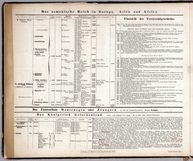
Full Title
(Text Page to) Das Osmanische Reichin Europe, Asien und Afrika. Leipzig, J.C. Hinrichs'sche Buch- und Landkartenhandlung. 1854. (to accompany) Stein, Neuer Atlas der ganzen Erde.
List No
8365.045
Note
Timeline history of Ottoman Empire in Europe, Asia and Africa.
Author
[Stein, Christ. Gottfr. Dan., Wagner, Karl Theodor]
Full Title
Vereinigten Staaten von Nord-Amerika. Entworfen und gezeichnet von Dr. F.W. Streit. Leipzig, J.C. Hinrichs'sche Buch- und Landkartenhandlung. 1851. (to accompany) Stein, Neuer Atlas der ganzen Erde. (insets) Die umgebungen von Washington, Boston, New York, Philadelphia und Trenton.
List No
8365.046
Note
Outline hand colored map by states. Relief shown by hachures. Shows administrative divisions, forts, canals, railroads, roads, etc. Includes explanations.
1-46 of 46
|