|
REFINE
Browse All : Case Map and Covers by Stanford, Edward
1-16 of 16
Author
[Ziegler, J. M., Stanford, Edward]
Full Title
(Covers to) Physical Map of the Island of Madeira constructed by J.M. Ziegler, Crrspg. F.R.G.S.ty from that of Captain Vidal, R.N. with Corrections . . .
List No
15940.001
Author
[Johnston, Alexander Keith, Stanford, Edward]
Full Title
(Covers to) Stanford's Library Map of Australasia.
List No
15896.001
Author
[Johnston, Alexander Keith, Stanford, Edward]
Full Title
(Covers to) Stanford's Library Map of Australasia.
List No
15896.002
Author
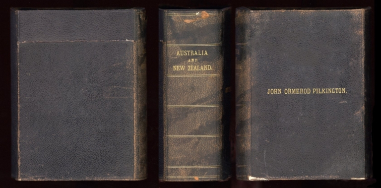
Stanford, Edward
Full Title
(Covers to) A map of Australia : constructed from the most recent official documents furnished by the Surveyors General and from the Admiralty surveys
List No
15890.001
Note
Name on cover: John Ormerod Pilkington
Author
Stanford, Edward
Full Title
(Covers to) Stanford's Handy Map of the United States Distinguishing The Unsettled Territories; The Railways; The Cities & Towns according to Population; also the State Capitals & County Towns. London: Edward Stanford, 55 Charing Cross, S.W., March 1st. 1876.
List No
2348.001
Author
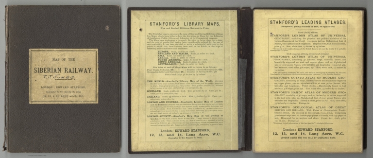
Stanford, Edward
Full Title
(Covers to) Stanford's Map Of The Siberian Railway, The Great Land Route To China And Korea. London; Published by Edward Stanford, 12, 13, & 14, Long Acre, W.C., Nov. 1, 1910. Stanford's Geographical Establishment, London.
List No
3303.001
Author
Stanford, Edward
Full Title
(Covers to) Stanford’s Map of the Empires of China and Japan, with the adjacent parts of the Russian Empire, India, Burma, &c.
List No
15126.001
Author
Stanford, Edward
Full Title
(Covers to) Stanford's Map Of India. Based On The Surveys Executed By Order Of The Honourable The East India Company, Special Maps Of The Surveyor General And Other Authorities; Showing The Latest Territorial Acquisitions And The Independent And Protected States, Railways, Canals, &c. 1859. London: Edward Stanford, 6, Charing Cross. Drawn & Engraved by J. & C. Walker. (inset) The Malay Peninsula &c. Showing The British Possessions Beyond The Ganges. (with 3 additional inset maps).
List No
0945A
Note
Full color. The insets include: The Malay Peninsula, Distances and Bearing from Calcutta, Distances and Bearings from Madras, and Distances and Bearings from Bombay. Map is in two sheets, each dissected into 36 sections. The two sheets fold with pale yellow end sheets labelled "North" and "South" into a brown cloth covered slip case 22x15.5 with a label reading "Stanford's Map Of India, Shewing The Latest Territorial Acquisitions of the British, the Independent and Protected States, Railways, Canals, Post Offices, Military Stations, &c. And Diagrams Exhibiting Distances & Bearings from the Three Presidencies of Bengal, Madras, and Bombay. London: Edward Stanford, 6, Charing Cross."
Author
Stanford, Edward
Full Title
(Covers to) Stanford's New Map of the County of London
List No
12292.001
Note
Black naugahyde box made to resemble a book. Decorative lines and text in gilt: "Map of the County of London. Stanford."
Author
Stanford, Edward
Full Title
(Covers to) Stanford's New Map of the County of London.
List No
12292.002
Note
Marbled red and blue panel covers on front and back of each of the five folded maps. Label on each in black text.
Author
[Stanford, Edward, W. & A.K. Johnston Limited]
Full Title
(Covers to) United States. W. & A.K. Johnston, Edinburgh. (inset) Plan Of Charleston, Vicinity And Harbour.
List No
3236A
Author
Stanford, Edward
Full Title
(Covers to) Stanford's Map Of The United States And Part Of The Dominion Of Canada. London: Published by Edward Stanford, 55 Charing Cross, September 1st 1875. (inset) Newfoundland, Nova Scotia, Cape Breton & Prince Edward Is.
List No
3780A
Note
Large hand colored and very detailed map of the United States and part of Canada. Up to date in the west, showing an extraordinary number of towns in California and Nevada. Topography is clearly delineated and Railroads are shown are far as they had been developed. Even Colorado is shown as a State (which occurred in 1876). Inset map of Nova Scotia and Newfoundland. There is a quote from Stansbury regarding the desert outside of Salt Lake City (a bit out of date, but shows attention to detail). The map makers certainly used the most current U.S. government maps as sources. On the verso is the label of Lanee, successor of Longuet, a Paris map seller, with Etats Unis in pen. Full color by state. Map is dissected into 40 sections, and edged and backed with linen. Folds into a new blue cloth folding case 25x17 with "United States Stanford 1875" stamped in gilt on the spine.
Author
Stanford, Edward
Full Title
(Covers to) Stanford's Library Map Of Asia. New Edition, 1895 ... London: Published by Edward Stanford, 26 & 27, Cockspur St., Charing Cross, S.W,. Decr., 1895. Stanford's Library Series. Stanford's Geographical Establishment.
List No
4150A
Note
Very large map in four sheets, each dissected into 20 sections. Still hand colored at this late date in full color by county. Each sheet folds with marbled end sheets labeled: North East, South East, North West, and South West. Outer case is a new quarter leather black cloth clam shell box 23x19 with "Maps Of Asia" stamped on the spine in gold.
Author
Stanford, Edward
Full Title
(Covers to) Stanford's New Large-Print Map Of The United States Of North America. Distinguishing The Cities & Towns According To Population &c. And Shewing The Boundary Of The Seceded States. London: Edward Stanford, 6, Charing Cross, May 13th 1861. Constructed & Engrd. at Stanford's Geographical Establishmt. London.
List No
5218A
Author
[Johnston, Alexander Keith, 1804-1871, Rogers, Henry Darwin, Stanford, Edward]
Full Title
(Covers to) Map Of The United States And Mexico With Canada, New Brunswick, Nova Scotia and Newfoundland, And Parts Of Central America & The West Indies. Constructed From State Documents & Unpublished Materials By Professor H.D. Rogers of Boston U.S. and A. Keith Johnston, F.R.S.E Geographer to the Queen. London; Published by Edward Stanford, 6 Charing Cross, S.W. May 13th. 1861. Additions to 1869.
List No
5402A
Note
This is the third issue of the 1857 Rogers and Johnston Map Of The United States (see our #4390) with Mexico added prominently to the title. Many changes in the western states and territories, not only in political boundaries, but also extensive topographical changes. The Peoples Pictorial Atlas of 1873 (see our #2307) has several maps that are derived from this map. Four sheets disected and folded with marbled end papers. Full color.
Author
Stanford, Edward
Full Title
(Covers to) Stanford's Railway & County Map Of The United States And Territories. London. Edward Stanford, 6, Charing Cross. 1861.
List No
5405A
Note
Although their names are not on the map, this is the United States portion only of Rogers and Johnston's 1857 Map of the United States (see our #4390). Significant changes from the 1857 edition in the west, showing Nevada, Colorado, and Arizona, though there appear to be no changes to the topography, only political boundaries. Map is dissected into 40 sections and mounted on linen. Folds into a green cloth covered case 24x16 with "Map Of The United States London: Edward Stanford, 6 Charing Cross, S.W." printed on paper and affixed to the front. Full color.
1-16 of 16
|