|
REFINE
Browse All : Railroad by Siebert, Selmar of California
1-13 of 13
Author
[Beckwith, Lieut., Schumann, C.]
Full Title
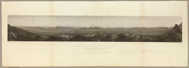
Valley of the Humboldt River at Lassen's Meadows. June 9th at 3 P.M. from a peak on the western Humboldt River range. C. Schumann from F.W. Egloffstein. Selmar Siebert's Engraving & Printing Establishment, Washington, D.C. U.S.P.R.R. Exp. & Surveys 41st Parallel. Expl. by Lieut. Beckwith. Vol. II.
List No
0693.012
Note
An uncolored extended view of the Lassen valley. The Sierra Nevadas and the upper Sacramento River can be seen in the background.
Author
[Beckwith, Lieut., Schumann, C.]
Full Title
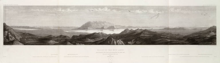
Valley of the Mud Lakes showing eighty two miles of the projected rail road line. June 14th at 9 A.M. from Mud Lake peak. C. Schumann from F.W. Egloffstein. Selmar Siebert's Engraving & Printing Establishment, Washington, D.C. U.S.P.R.R. Exp. & Surveys 41st Parallel. Expl. by Lieut. Beckwith. Vol. II.
List No
0693.013
Note
Uncolored view including the eastern base of the Sierra Nevadas and the Oregon road entering the Sierra Nevada.
Author
[Beckwith, Lieut., Schumann, C.]
Full Title
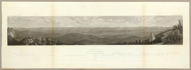
Madelin Pass. June 19th at 2 P.M. view taken from Mount Observation. C. Schumann from F.W. Egloffstein. Selmar Siebert's Engraving & Printing Establishment, Washington, D.C. U.S.P.R.R. Exp. & Surveys 41st Parallel. Expl. by Lieut. Beckwith. Vol. II.
List No
0693.014
Note
Uncolored view showing the stretch looking east from Mt. Shasta to the Sierras west of Pyramid Lake.
Author
[Beckwith, Lieut., Schumann, C.]
Full Title
West End of Madelin Pass. June 26th at 8 A.M. from a peak overlooking Madelin Creek. C. Schumann from F.W. Egloffstein. Selmar Siebert's Engraving & Printing Establishment, Washington, D.C. U.S.P.R.R. Exp. & Surveys 41st Parallel. Expl. by Lieut. Beckwith. Vol. II.
List No
0693.015
Note
Uncolored view to the north showing the Sacramento River descending through the Round Valley. Mt. Shasta is shown in the background.
Author
[Beckwith, Lieut., Schumann, C.]
Full Title
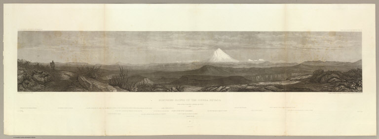
Northern Slopes of the Sierra Nevada. June 30th at 9 A.M. view towards the West 1854. C. Schumann from F.W. Egloffstein. Selmar Siebert's Engraving & Printing Establishment, Washington, D.C. U.S.P.R.R. Exp. & Surveys 41st Parallel. Expl. by Lieut. Beckwith. Vol. II.
List No
0693.016
Note
View uncolored. The center of the view is dominated by Mt. Shasta, 50 miles in the distance. The view is looking to the west with the Coast Range 100 miles in the distance.
Author
[Beckwith, Lieut., Schumann, C.]
Full Title
Portion of the main mountain passage of the upper Sacramento or Pitt River. July 20th at 1 P.M. 25 miles south of Mt. Shasta. C. Schumann from F.W. Egloffstein. Selmar Siebert's Engraving & Printing Establishment, Washington, D.C. U.S.P.R.R. Exp. & Surveys 41st Parallel. Expl. by Lieut. Beckwith. Vol. II.
List No
0693.017
Note
Uncolored view looking to Mt. Shasta in the north.
Author
Beckwith, E.G.
Full Title
From the Mud Lakes to the Pacific Ocean; from Explorations and Surveys made under the direction of the Hon. Jefferson Davis Secretary of War by Capt. E.G. Beckwith, 3d. Artillery. F.W. Egloffstein, Topographer for the Route. 1855. Explorations and surveys for a railroad route from the Mississippi River to the Pacific Ocean. War Department. Route near the 41st Parallel. Map No. 4. Selmar Siebert's Engraving & Printing Establishment. Washington, D.C.
List No
0693.031
Note
Uncolored map drawn in detail from Pyramid Lake in present-day Nevada to Mt. Shasta. The rest of the map is in sketchy detail.
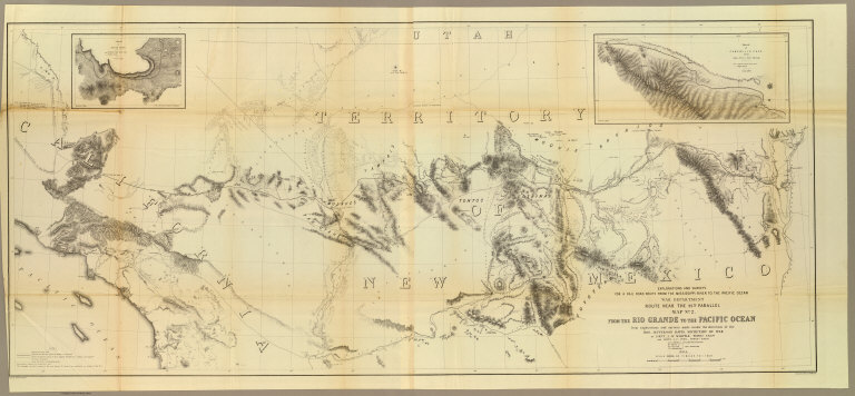
Author
[Ives, J.C., Whipple, A.W.]
Full Title
From the Rio Grande to the Pacific Ocean from explorations and surveys made under the direction of the Hon. Jefferson Davis, Secretary of War by Lieut. A.W. Whipple, Topogl. Engrs. and Lieut. J.C. Ives, Topogl. Engrs. A.H. Campbell, Civil Eng. and Surveyor, Asst. Surveyors: Wm. White Jr., N.H. Hutton, and J.P. Sherburne. 1853-4. Explorations and Surveys for a Rail Road Route from the Mississippi River to the Pacific Ocean, War Department, Route Near the 35th Parallel, Map No. 2. Engr. by Selmar Siebert. Drawn by John D. Hoffmann.
List No
0693.038
Note
The uncolored map stretches from Albuquerque in the east across the southwest to Los Angeles. With two inset maps: "Sketch of Campbell's Pass from Agua Azul to Salt Spring" and "Sketch of Aztec Pass."
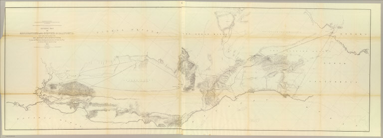
Author
Williamson, R.S.
Full Title
General Map of Explorations and Surveys in California made under the direction of the Hon. Jefferson Davis, Secretary of War by Lieut. R.S. Williamson, Topogl. Engr. assisted by Lieut. J.G. Parke, Topl. Engr. and Mr. Isaac Williams Smith, Civ. Engr. 1853. Explorations and Surveys for a Rail Road Route from the Mississippi River to the Pacific Ocean. War Department. Routes in California to connect with the routes near the 32nd and 35th parallels. Engr. by Selmar Siebert.
List No
0693.040
Note
A north/south view of California from the San Francisco Bay to San Diego. The railway line is shown extending as far east as Fort Yuma. Without color.
Author
Williamson, R.S.
Full Title
Map of Passes in the Sierra Nevada from Walker's Pass to the Coast Range: from Explorations and Surveys made under the direction of the Hon. Jefferson Davis, Secretary of War by Lieut. R.S. Williamson Topl. Engr. assisted by Lieut. J.G. Parke Topl. Engr. and Mr. Isaac Williams Smith, Civ. Engr. 1853. Explorations and Surveys for a Rail Road Route from the Mississippi River to the Pacific Ocean. War Department. Routes in California to connect with the routes near the 32nd and 35th parallels. Engraved by Selmar Siebert.
List No
0693.041
Note
Map uncolored.
Author
Williamson, R.S.
Full Title
Map and Profile of the Canada de las Uvas; from Explorations and Surveys made under the direction of the Hon. Jefferson Davis, Secretary of War by Lieut. R.S. Williamson Topl. Engr. assisted by Lieut. J.G. Parke Topl. Engr. and Mr. Isaac Williams Smith, Civ. Engr. 1853. Explorations and Surveys for a Rail Road Route from the Mississippi River to the Pacific Ocean. War Department. Routes in California to connect with the routes near the 32nd and 35th parallels. Engr. by Selmar Siebert.
List No
0693.042
Note
Uncolored.
Author
Williamson, R.S.
Full Title
Map and Profile of the Tejon Pass; from Explorations and Surveys made under the direction of the Hon. Jefferson Davis, Secretary of War by Lieut. R.S. Williamson Topl. Engr. assisted by Lieut. J.G. Parke Topl. Engr. and Mr. Isaac Williams Smith, Civ. Engr. 1853. Explorations and Surveys for a Rail Road Route from the Mississippi River to the Pacific Ocean. War Department. Routes in California to connect with the routes near the 32nd and 35th parallels. Engr. by Selmar Siebert.
List No
0693.043
Note
Uncolored.
Author
Parke, John G.
Full Title
From the Pimas Villages to Fort Fillmore from Explorations and Surveys made under the direction of The Hon. Jefferson Davis, Secretary of War by Lieut. John G. Parke, Topl. Engrs. assisted by Albert H. Campbell, Civil Engineer and N.H. Hutton, H. Custer and G.G. Garner. 1854 & 55. Map No. 2. Engr. by Selmar Siebert. Explorations and Surveys for a Rail Road Route from the Mississippi River to the Pacific Ocean. War Department. Route near the 32nd parallel of North Latitude.
List No
0693.047
Note
Area shown is just north of the boundary line between Mexico and the United States. Uncolored. Note states that some of the information on the map was taken from Emory survey and the office of the U.S. Mexican Boundary Commission.
1-13 of 13
|