|
REFINE
Browse All : Images by Schofield, John M. of Atlanta Region (Ga.)
1-3 of 3
Author
[Morris, Walter J., United States. War Department]
Full Title
Map of the fall campaigns of the Army of Missouri, Maj. Gen. Sterling Price, commanding in Sept., Oct., Nov. 1864. Capt. T.J. Mackey, Chf. Engr. (with) No. 2. Map of the battle of Chickamauga showing the positions of the Confederate and Federal armies on the 19th September, 1863 ... by Walter J. Morris ... (with) No. 3. Map of the battle of Chickamauga ... 19th September 1863 ... by Walter J. Morris ... (with Marietta Region, Georgia). Accompanying letter of Maj. Gen. J.M. Scholfield ... (with Peach Tree Creek Region, Georgia) Marked "Thomas" by Gen. Sherman. (with) Mine Run, Va. and vicinity, 1863. (with) No. 1. Map showing the positions of the Confederate Army and that of the Federal Army at midnight on the 18th of September, 1863, the night previous to the general engagements of the 19th and 20th Sept., or the Battle of Chickamauga ... by Walter J. Morris ... (with) Map of the engagement at Wauhatchie, Tenn., October 28th and 29th, 1863 and of the operations of the 11th and 12th Army Corps preliminary thereto. Accompanying report of Maj. Gen. Joseph Hooker. Julius Bien & Co., Lith., N.Y. (1891-1895)
List No
1780.047
Note
Col. map with 7 ancillary maps. Relief in some ancillary maps shown by hachures or form lines.
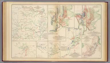
Author
United States. War Department
Full Title
Line of march of the Left Wing, 16th Army Corps from May 5th to Sept. 8th, 1864. (with) Position of the Left Wing, 16th A.C. ... July 11, 1864. (with) Map showing the position of Left Wing, 16th Army Corps during the engagement near Atlanta July 22, 1864. (with Atlanta Campaign). (with) Diagram of the battle-field occupied by Gen. Blair, 17th Army Corps ... July 5th to 11th 1864 on the Chattahoochee. (with) Position of Left Wing ... in front of Kenesaw Mountain. (with) Map showing position of the Confederate armies of Mississippi and Tennessee under command of Gen. J.E. Johnston May 19th 1864. (with) Position of 4th Div., 17th Army Corps, July 22d, 1864. (with) Diagram of the general situation during the siege of Atlanta. (with Marietta Ga. June 10-July 3, 1864). (with) Diagram showing the advance of the 3d. Brig., 4th Div., 17th Corps on the Sandtown Road to Widow Mitchell's farm and from there east to the Nickajack. July 3, 4 and 5th 1864. (with) Diagram showing the flank movement of the 17th Army Corps from Turner's Ferry, July 16, 1864, by way of Marietta and Roswell to south of Decatur and east of Atlanta to the extreme left of the Army. (with Marietta, Ga. June 10-July 3, 1864). (with Marietta Ga. June 10-July 3, 1864). Julius Bien & Co., Lith., N.Y. (1891-1895)
List No
1780.062
Note
Col. map with 13 ancillary maps. Relief shown by hachures. Maps accompany documents from or in possession of G.M. Dodge, J.S. Fullerton, W.T. Sherman and J.M. Schofield
Author
[United States. War Department, Walker, Tipton]
Full Title
Coast of Texas and its defenses, Capt. Tipton Walker, Chief of Topographical Bureau of Texas, New Mexico and Arizona, drawn by P. Helferich, Asst. Engr. 1864. (with) Engineer Office, 10th Army Corps, sketch no. 8 of road between Bermuda Hundred and enemy's first line of intrenchments on the north and Petersburg on the south. T.B. Brooks, Maj. A.D.C. and Directing Engineer. (with Marietta, Ga., June 10-July 3, 1864). Original marked "Thomas and Schofield." (with Marietta, Ga., June 10-July 3, 1864). Original marked "Garrard." (with) Schofield crossing the Chattahoochee. (with Marietta, Ga., June 10-July 3, 1864). (with) No. 3. Sketch of defensive works at Deep Bottom, Va. (with) Section through Dutch Gap, James River, Va. (with) Plan of Dutch Gap Canal and fortifications, James River, Va., Sept. 10, 1864. P.S. Michie. (with) No. 2. Sketch of road from pontoon-bridge at Point of Rocks to Petersburg, showing line of works captured by 18th Army Corps. Julius Bien & Co., Lith., N.Y. (1891-1895)
List No
1780.065
Note
Col. map. with 9 ancillary maps. Relief on some ancillary maps shown by hachures. Includes drawings of 14 fortifications at 1:10,000. Accompanying reports or letters of G. Weitzel and J.M. Schofield or in possession of W.T. Sherman.
1-3 of 3
|