|
REFINE
Browse All : Geology by Rogers, Henry Darwin
1-7 of 7
Author
[Johnston, Alexander Keith, 1804-1871, Rogers, Henry Darwin]
Full Title
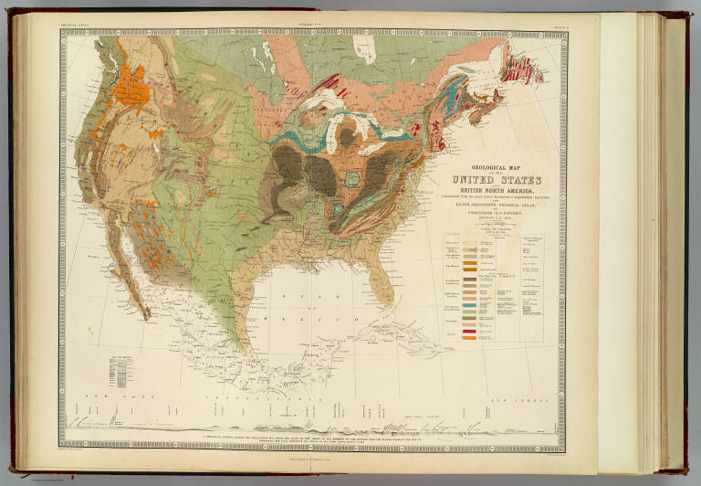
Geological map of the United States and British North America, constructed from the most recent documents & unpublished materials, for Keith Johnston's Physical atlas by Professor H.D. Rogers, Boston, U.S., 1855. Engraved & printed in colours by W. & A.K. Johnston. William Blackwood & Sons, Edinburgh & London. (1856)
List No
0372.009
Note
Col. lithographed map. Includes "A geological section across the Appalachian Mts. from the coast of New Jersey at Egg Harbour to Lake Ontario near the Niagara River, ... by Prof. Henry Darwin Rodgers (sic), U.S., 1854. Covers also Northern Mexico. "Geology no. 8."
Author
Rogers, Henry Darwin
Full Title
Geological Map of the United States and British North America.
List No
0372AA
Author
Rogers, Henry Darwin
Full Title
Geological Map of the United States and British North America. (continued)
List No
0372AB
Author
Rogers, Henry Darwin
Full Title
Geological Map of the United States and British North America. (continued)
List No
0372AC
Author
Rogers, Henry Darwin
Full Title
Geological Map of the United States and British North America. (continued)
List No
0372AD
Author
Rogers, Henry Darwin
Full Title
A Geological Map of New Jersey, by Henry D. Rogers, Prof. of Geology in Univ. of Penna. (To accompany the Report on the Geology of N. Jersey,) Jan. 1839. P.S. Duval, Lith. Philada. On Stone by J. Probst.
List No
3346.000
Note
Marcou lists this as the first Geological map of New Jersey. Accompanies Rogers' "Description of the geology of the State of New Jersey, being a final report," Philadelphia, 1840. Report not present here. Rodgers used the Gordon/Tanner map as a base. Full color by geological formation. Relief shown by hachures.
Author
Rogers, Henry Darwin
Full Title
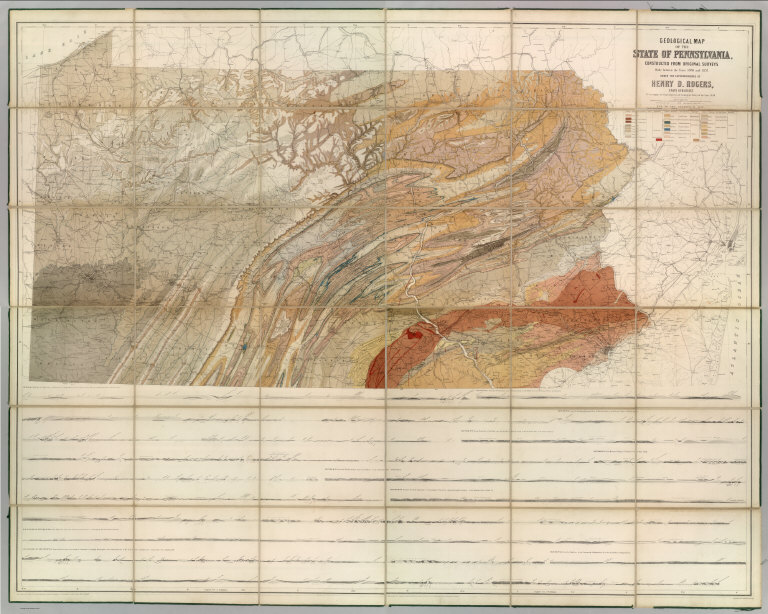
Geological Map Of The State Of Pennsylvania, Constructed From Original Surveys Made between the Years 1836 and 1857, Under The Superintendence Of Henry D. Rogers, State Geologist. To Accompany the Final Report on the Geological Survey of the State 1858. Entered ... 1858 by Henry D. Rogers ... Pennsylvania. Engraved by W. & A.K. Johnston Edinburgh.
List No
4120.000
Note
This large map was intended to accompany the text volumes of the Final Report on the First Geological Survey of Pennsylvania, 1858. The map is fully colored to show geological formations, and has nine sections below the map. W. & A.K. Johnston engraved the map, further evidence of their collaboration with Rogers in addition to the 1857 Atlas of the United States. Printed full color. Edged in green cloth, this map is dissected into 36 sections and folds into marbled end sheets with a new blue cloth folding case 32x26 titled "Geological Map Of Pennsylvania Henry D. Rogers 1858" in gold on the spine.
1-7 of 7
|