|
REFINE
Browse All : Images by Reed, Abner
1-5 of 5
Author
[Bourne, A., Kilbourne, J., Reed, Abner]
Full Title
Map Of The State Of Ohio. Drawn by A. Bourne. Including the Indian Reservations, Purchased and laid out into Counties and Townships in 1820, Drawn by J. Kilbourne. Engraved by A. Reed.
List No
0086.000
Note
Published in: Caleb Atwater, "Description of the antiquities discovered in the state of Ohio," Archaeologica Americana, Vol 1, 1820 (see our #3387). An excellent, very early map showing the absorption of Indian land in the northwest for settlement. Engraved by Abner Reed of East Windsor, Connecticut. Bourne and Hough did a larger Ohio map in 1815. Color map, showing rivers, roads, vegetation, and place names. Relief shown by shadings and hachures.
Author
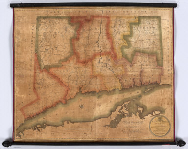
[Gillet, George, Warren, Moses]
Full Title
Connecticut, From Actual Survey, Made in 1811; By and under the Direction of, Moses Warren and George Gillet; And by them Compiled. Published under the Authority of The General Assembly, By Hudson & Goodwin. Engraved By Abner Reed, E. Windsor. Entered ... 29th day of May, 1813 - By Hudson & Goodwin ... Connecticut. To His Excellency Roger Griswold, Esq. And to The Honourable, The Legislature of The State of Connecticut, This Map is Respectfully Inscribed By the Publishers. Hartford, February 1812.
List No
2473.000
Note
First detailed 19th century survey. Has Humphrysville "Woolen Manufactory..." notation, thus 1st edition, 2nd state (Thompson). Foundation map of state, first to show turnpikes. Extensive listing of manufactories, mills, churches, etc. Later published in smaller size, editions from 1820 to 1847. Engraved by Abner Reed, East Winsor. Thompson lists this same map as 1812, but it is entered in 1813, and the current Governor is listed as 1813-, leading one to believe an 1813 date would be more accurate. Outline color. With black top and bottom rollers.
Author
Woodbridge, William C.
Full Title
Polar projection of North America & Asia. Comparative, geographical & statistical map of North America adapted to Woodbridge's Geography. Comparative, geographical & statistical map of Asia, Adapted to Woodbridge's Geography. Engraved on steel, by A. Reed. Entered ... 1831 by William C. Woodbridge ... Connecticut. (1837?)
List No
2573.008
Note
Engraved map. Hand colored. Relief shown by hachures. David Rumsey Collection copy has part of China outlined in dark green ink.
Author
[Bourne, A., Kilbourne, J., Reed, Abner]
Full Title
(Covers to) Map Of The State Of Ohio From the latest & best Authorities; Including the Census of 1830. Engraved by A. Reed, East Windsor Connecticut; 1831. Published by Silas Andrus, Hartford Con.
List No
4908.001
Note
This is an updated edition of the 1820 Map of the State of Ohio by Bourne and Kilbourne (see our #86). Only Reed's name appears on the title credits. There are many changes and updates in the map, including the Portsmouth Canal ("306 miles long") and the places of the 1830 census figures in each county. Full color map by county, folded into black leather covers 13x8 with "Ohio." in gilt.
Author
[Bourne, A., Kilbourne, J., Reed, Abner]
Full Title
Map Of The State Of Ohio From the latest & best Authorities; Including the Census of 1830. Engraved by A. Reed, East Windsor Connecticut; 1831. Published by Silas Andrus, Hartford Con.
List No
4908.002
Note
This is an updated edition of the 1820 Map of the State of Ohio by Bourne and Kilbourne (see our #86). Only Reed's name appears on the title credits. There are many changes and updates in the map, including the Portsmouth Canal ("306 miles long") and the places of the 1830 census figures in each county. Full color map by county, folded into black leather covers 13x8 with "Ohio." in gilt.
1-5 of 5
|