|
REFINE
Browse All : Images by Rand McNally and Company of Kentucky
1-34 of 34
Author
[Rand McNally and Company, Refiners Oil Company]
Full Title
Refiners Oil Co. Road map of Indiana Ohio Kentucky. A section of Rand McNally official road map of N. E. United States, Copyright by Rand McNally & Co. Chicago, Ill. Made in U.S.A. (Cover title) Refiners road map of Ohio - Indiana - Kentucky. Complement of the Refiners Oil Co.
List No
11371.002
Note
Rand McNally official auto road map, printed on heavy paper on sheet 30.5x46, folded to 23x10. Date estimated. Shows paved and improved roads, state and U.S. highways Principal cities, capitals, population, traffic signs, etc. On verso: Cover, mileage chart, advertisement and text. Include 4 city map with index, covering Dayton, Ohio; Columbus, Ohio; Cincinnati, Ohio and Richmond, Ohio on verso.
Author
Rand McNally and Company
Full Title
(Text Page) Ohio. Kentucky.
List No
2094BH
Note
List of geographical features indexed to map.
Author
Rand McNally and Company
Full Title
(Text Page) Kentucky.
List No
2094BI
Note
List of geographical features indexed to map.
Author
Rand McNally and Company
Full Title
(Text Page) Kentucky.
List No
2094BJ
Note
List of geographical features indexed to map.
Author
Rand McNally and Company
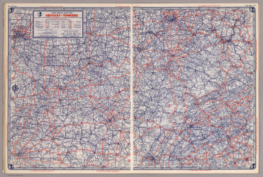
Full Title
Rand, McNally & Co.'s Kentucky and Tennessee. New County and Railroad Map of Kentucky. County and Railroad Map of Tennessee.
List No
2094.030
Note
Counties outlined in color. Meridians Washington and Greenwich. Railroads highlighted. One inset. Relief shown by hachures.
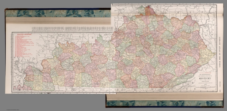
Author
Rand McNally and Company
Full Title
Kentucky.
List No
2790.130
Author
Rand McNally and Company
Full Title
(Composite Map) Kentucky.
List No
2790.131
Author
Rand McNally and Company
Full Title
Relief Map of Kentucky.
List No
2790.133
Author
Rand McNally and Company
Full Title
Rand, McNally & Co.'s Kentucky and Tennessee.
List No
2844.038
Note
Relief shown by hachures. Railroads and chief cities listed and keyed to map.
Author
Rand McNally and Company
Full Title
(Text Page) Rand, McNally Co.'s Kentucky.
List No
2844BP
Note
Tables of railroads and geographical features keyed to map.
Author
Rand McNally and Company
Full Title
Rand, McNally & Co.'s Louisville.
List No
2844.039
Note
Inset extension of city map.
Author
Rand McNally and Company
Full Title
(Text Page) Rand, McNally Co.'s Kentucky.
List No
2844BQ
Note
Tables of geographical features keyed to map.
Author
Rand McNally and Company
Full Title
(Text Page) Rand, McNally Co.'s Kentucky.
List No
2844BR
Note
Tables of geographical features keyed to map.
Author
Rand McNally and Company
Full Title
(Text Page) Rand, McNally Co.'s Kentucky.
List No
2844BS
Note
Tables of geographical features keyed to map.
Author
Rand McNally and Company
Full Title
Rand, McNally & Co.'s New business atlas map of Kentucky & Tennessee. Copyright, 1889, by Rand, McNally & Co. (Chicago, 1897)
List No
3565.101
Note
Col. map. Relief shown by hachures and spot heights. Title in margin: Rand, McNally & Company's Indexed atlas of the world. Tennessee and Kentucky.
Author
Rand McNally and Company
Full Title
Rand, McNally & Co.'s indexed atlas of the world map of Louisville. Rand, McNally & Co's New business atlas map of Louisville, Ky. Copyright, 1892 ... Rand, McNally & Co., Engravers, Chicago. (1897)
List No
3565.102
Note
Col. map. Shows major buildings, parks, cemeteries, ferries, etc. Inset: Southern extension of Louisville. "Rand, McNally & Company's" in margin.
Author
Rand McNally and Company
Full Title
Rand, McNally & Co.'s indexed atlas of the world map of Cincinnati and environs. Rand, McNally & Co's New business atlas map of Cincinnati. Copyright, 1891 ... Rand, McNally & Co., Engravers, Chicago. (1897)
List No
3565.105
Note
Col. map. Shows major buildings, parks, cemeteries, ferries, etc. Inset: Business portion of Cincinnati on enlarged scale. (Scale ca. 1:11,500). Title in margin: Rand, McNally & Company's indexed atlas of the world.
Author
Rand McNally and Company
Full Title
Rand McNally Junior Auto Road Map of Kentucky, Tennessee. Copyright by Rand McNally & Company. Chicago, Ill. Made in U.S.A. P.1052.
List No
4245.008
Note
Color map. Includes explanation, and alphabetical index of cities and towns, giving populations and Key to map. U.S. interstate highways shown in red. Shows Highway markers.
Author
Rand McNally and Company
Full Title
Rand, McNally & Co.'s Kentucky and Tennessee.
List No
4520.029
Note
In outline color by county. Shows named railroads. Relief shown by hachures.
Author
Rand McNally and Company
Full Title
(Text Page) Industrial Statistics of the United States. Kentucky. Louisiana. Maine.
List No
5028AA
Note
Industrial statistics by state and county including county seat, area, and statistics on population, agriculture and manufacturing. Includes descriptions of mines, quarries, and wells.
Author
Rand McNally and Company
Full Title
(Text Page) Tennessee - Counties, Creeks, Mountains, Rivers, and Towns. Kentucky - Counties, Creeks, Mountains, Rivers, and Towns.
List No
5028CE
Note
Geographical features keyed to map; populations of towns. Shows electric lines.
Author
Rand McNally and Company
Full Title
Commercial Atlas of America. Rand McNally Standard Map of Kentucky.
List No
5028.067
Note
Shows railroads and distances. Includes tables of principal cities and railroads, keyed to map.
Author
Rand McNally and Company
Full Title
(Text Page) Kentucky - Counties, Creeks, Mountains, Rivers, and Towns.
List No
5028CF
Note
Geographical features keyed to map; populations of towns. Shows electric lines.
Author
Rand McNally and Company
Full Title
(Text Page) Kentucky - Counties, Creeks, Mountains, Rivers, and Towns.
List No
5028CG
Note
Geographical features keyed to map; populations of towns. Shows electric lines.
Author
Rand McNally and Company
Full Title
(Text Page) Kentucky - Counties, Creeks, Mountains, Rivers, and Towns.
List No
5028CH
Note
Geographical features keyed to map; populations of towns. Shows electric lines.
Author
Rand McNally and Company
Full Title
Commercial Atlas of America. Rand McNally Black and White Mileage Map, Kentucky.
List No
5028.068
Note
Shows railroads and distances.
Author
Rand McNally and Company
Full Title
Commercial Atlas of America. Rand McNally AutoTrails Map, District Number 2, Eastern Illinois, Southern Mich., Indiana, Western Ohio, Northern Ky.
List No
5028.083
Note
Shows roads and distances. Shows table of highway names, numbers, and markings.
Author
Rand McNally and Company
Full Title
Commercial Atlas of America. Rand McNally AutoTrails Map, District Number 19, (Missouri, Arkansas, Kentucky, Tennessee).
List No
5028.112
Note
Shows roads and distances. Shows table of highway names, numbers, and markings. Relief shown by hachures.
Author
Rand McNally and Company
Full Title
Rand McNally junior auto road map Kentucky, Tennessee. Copyright by Rand McNally & Company, Chicago, Ill. (1927)
List No
5755.015
Note
Color map. Relief shown by hachures. Shows settlements, classified roads with distances, etc. "I-18."
Author
Rand McNally and Company
Full Title
(Covers to) Rand, McNally & Co.'s New Shippers' Railroad Map of the United States. Scale: 8 miles to one inch. Showing all railroads, each in a separate color, and all railroad stations in large, plain type. (Below the neatline) Rand, McNally & Co.'s New Shippers' Railroad Map of the United States, Copyright, 1888 by Rand, McNally & Co. Copyright, 1891 by Rand, McNally & Co.
List No
5802H
Note
This is the Tennessee/North Carolina/Kentucky section of the larger map.
Author
Rand McNally and Company
Full Title
Rand, McNally & Co.'s New Shippers' Railroad Map of the United States. Scale: 8 miles to one inch. Showing all railroads, each in a separate color, and all railroad stations in large, plain type. (Below the neatline) Rand, McNally & Co.'s New Shippers' Railroad Map of the United States, Copyright, 1888 by Rand, McNally & Co. Copyright, 1891 by Rand, McNally & Co.
List No
5802.008
Note
This is the Tennessee/North Carolina/Kentucky section of the larger map.
Author
[Bayer, Herbert, Container Corporation of America]
Full Title
Kentucky. U.S. State. (Vicinities of Paducah, Louisville, and Cincinnati).
List No
5842.061
Note
Map and graphics showing principal resources, population, occupations, manufacturing, mineral production, agriculture, and land use. Includes brief history and description of state's features. Relief depicted by hachures.
Author
[State Farm Insurance Companies Travel Bureau, Rand McNally and Company]
Full Title
Rand McNally Road map, Kentucky - Tennessee. Copyright by Rand McNally & Company, Chicago, Ill. Lithographed in the U.S.A. (to accompany) State Farm Road Atlas: United States, Canada, Mexico,Central and South America. Copyright 1940 by Rand McNally & Company, Chicago, Ill.
List No
5969.033
Note
Color map. U.S. interstate highways shown in red. Shows roads, capitals, population of cities and towns, etc. Relief shown by hachures and spot heights.
Author
[Rand McNally and Company, State Farm Insurance Companies Travel Bureau]
Full Title
Rand McNally Road map: Kentucky - Tennessee. Copyright by Rand McNally & Company, Chicago, Ill. Lithorgaphed in the U.S.A. U.3615. (to accompany) State Farm road atlas : United States, Canada, Mexico.
List No
6825.030
Note
Color map. U.S. interstate highways shown in red. Shows time zone boundaries, roads, ferries, highways, rivers and streams. Includes population of cities and towns. Relief shown by hachures.
1-34 of 34
|