|
Author
Philip, George
Full Title
(Covers to) The World on Mercator's Projection.
List No
15404.001
Note
Date estimated.
Author
Philip, George
Full Title
The World on Mercator's Projection.
List No
15404.002
Note
Date estimated.
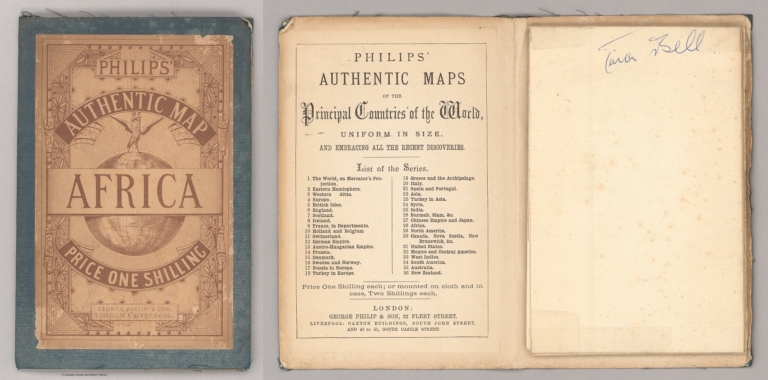
Author
Philip, George
Full Title
(Covers to) Africa. George Philip & Son, London & Liverpool.
List No
2272.001
Note
Date estimated
Author
Philip, George
Full Title
Africa. George Philip & Son, London & Liverpool.
List No
2272.002
Note
Date estimated
Author
[Bartholomew, John, Philip, George]
Full Title
The Pacific States, The Territories And A Portion Of The North-Western States. By J. Bartholomew, F.R.G.S. George Philip & Son, London & Liverpool. (above the title) (United States, No. II (Western Division).
List No
3085.000
Note
Date estimated.
Author
Philip, George
Full Title
(Title Page to) Philips' Mercantile Marine Atlas. A Series Of 30 Plates Containing Over 100 Charts & Plans, With Tables Of 8,600 Distances Between Ports, National & House Flags, Lists Of British & United States Consulates, And Complete Index Of 20,000 Ports, &c. Specially Designed For Merchant Shippers, Exporters & Ocean Travellers And For General Use. Edited By George Philip, F.R.G.S. Second Edition. London: George Philip & Son, Ltd., The London Geographical Institute, 32 Fleet Street, E.C. Liverpool: Philip, Son & Nephew, 45 To 51 South Castle Street. 1905. All Rights Reserved. Entered at Stationers Hall.
List No
0724.002
Note
2nd edition, 1905 Philip's Philips' Mercantile Marine Atlas. Edited by George Philip. Published by George Philip & Son and London Geographical Institute in 1905. Maps are double page, printed in full color, including general maps and diagrams, navigation charts and physical maps. Showing mail routes, steamship routes, distances, cities, towns, populations, naval stations, cables, light houses, navigable waters, canals, roads and railroads. Depth shown by gradient tints and soundings. Atlas also includes statistical summary: table of distances, list of British and American consulates, Foreign money values, and index. It's bound in half leather dark blue cloth covered boards with "Philips' Mercantile Marine Atlas Of The World" embossed on the front cover and the spine in gilt.
Author
Philip, George
Full Title
Index map to charts 1-19. George Philip & Son, Ltd. The London Geographical Institute. (to accompany) Philips' Mercantile Marine Atlas. Second Edition ... 1905.
List No
0724.006
Note
Index to navigation charts 1-19. Includes reference.
Author
Philip, George
Full Title
Commercial chart, World. George Philip & Son, Ltd. The London Geographical Institute. (to accompany) Philips' Mercantile Marine Atlas. Second Edition ... 1905. (insets) Magnetic parallels and meridians. (with) Variation of the compass, isogonic lines.
List No
0724.009
Note
Double page colored map. Shows colonial territories, steamer routes, distances, principal railways, telegraph cables, seas icebound in winter and comparative time. Relief shown by hachures. Includes reference.
Author
Philip, George
Full Title
The North Atlantic Ocean. George Philip & Son, Ltd. The London Geographical Institute. (to accompany) Philips' Mercantile Marine Atlas. Second Edition ... 1905. (insets) Magnetic parallels and meridians. (with) Variation of the compass, isogonic lines.
List No
0724.010
Note
Double page colored map, with 2 insets of parts of West Africa. Shows political divisions, towns, populations, mail routes, steamship routes, distances, principal railways, telegraph cables, navigable waters, canals, lighthouses, harbors, British and American consular offices, naval stations, dockyards, etc. Depth shown by gradient tints and soundings. Includes reference to general map.
Author
Philip, George
Full Title
(Covers to) Philips' Mercantile Marine Atlas. A Series Of 30 Plates Containing Over 100 Charts & Plans, With Tables Of 8,600 Distances Between Ports, National & House Flags, Lists Of British & United States Consulates, And Complete Index Of 20,000 Ports, &c. Specially Designed For Merchant Shippers, Exporters & Ocean Travellers And For General Use. Edited By George Philip, F.R.G.S. Second Edition. London: George Philip & Son, Ltd., The London Geographical Institute, 32 Fleet Street, E.C. Liverpool: Philip, Son & Nephew, 45 To 51 South Castle Street. 1905. All Rights Reserved. Entered at Stationers Hall.
List No
0724.001
Note
2nd edition, 1905 Philip's Philips' Mercantile Marine Atlas. Edited by George Philip. Published by George Philip & Son and London Geographical Institute in 1905. Maps are double page, printed in full color, including general maps and diagrams, navigation charts and physical maps. Showing mail routes, steamship routes, distances, cities, towns, populations, naval stations, cables, light houses, navigable waters, canals, roads and railroads. Depth shown by gradient tints and soundings. Atlas also includes statistical summary: table of distances, list of British and American consulates, Foreign money values, and index. It's bound in half leather dark blue cloth covered boards with "Philips' Mercantile Marine Atlas Of The World" embossed on the front cover and the spine in gilt.
Author
Philip, George
Full Title
(Text Page to) Philips' Mercantile Marine Atlas. A Series Of 30 Plates Containing Over 100 Charts & Plans, With Tables Of 8,600 Distances Between Ports, National & House Flags, Lists Of British & United States Consulates, And Complete Index Of 20,000 Ports, &c. Specially Designed For Merchant Shippers, Exporters & Ocean Travellers And For General Use. Edited By George Philip, F.R.G.S. Second Edition. London: George Philip & Son, Ltd., The London Geographical Institute, 32 Fleet Street, E.C. Liverpool: Philip, Son & Nephew, 45 To 51 South Castle Street. 1905. All Rights Reserved. Entered at Stationers Hall.
List No
0724.003
Note
2nd edition, 1905 Philip's Philips' Mercantile Marine Atlas. Edited by George Philip. Published by George Philip & Son and London Geographical Institute in 1905. Maps are double page, printed in full color, including general maps and diagrams, navigation charts and physical maps. Showing mail routes, steamship routes, distances, cities, towns, populations, naval stations, cables, light houses, navigable waters, canals, roads and railroads. Depth shown by gradient tints and soundings. Atlas also includes statistical summary: table of distances, list of British and American consulates, Foreign money values, and index. It's bound in half leather dark blue cloth covered boards with "Philips' Mercantile Marine Atlas Of The World" embossed on the front cover and the spine in gilt.
Author
Philip, George
Full Title
(Text Page to) Philips' Mercantile Marine Atlas. A Series Of 30 Plates Containing Over 100 Charts & Plans, With Tables Of 8,600 Distances Between Ports, National & House Flags, Lists Of British & United States Consulates, And Complete Index Of 20,000 Ports, &c. Specially Designed For Merchant Shippers, Exporters & Ocean Travellers And For General Use. Edited By George Philip, F.R.G.S. Second Edition. London: George Philip & Son, Ltd., The London Geographical Institute, 32 Fleet Street, E.C. Liverpool: Philip, Son & Nephew, 45 To 51 South Castle Street. 1905. All Rights Reserved. Entered at Stationers Hall.
List No
0724.004
Note
2nd edition, 1905 Philip's Philips' Mercantile Marine Atlas. Edited by George Philip. Published by George Philip & Son and London Geographical Institute in 1905. Maps are double page, printed in full color, including general maps and diagrams, navigation charts and physical maps. Showing mail routes, steamship routes, distances, cities, towns, populations, naval stations, cables, light houses, navigable waters, canals, roads and railroads. Depth shown by gradient tints and soundings. Atlas also includes statistical summary: table of distances, list of British and American consulates, Foreign money values, and index. It's bound in half leather dark blue cloth covered boards with "Philips' Mercantile Marine Atlas Of The World" embossed on the front cover and the spine in gilt.
Author
Philip, George
Full Title
(Contents to) Philips' Mercantile Marine Atlas. A Series Of 30 Plates Containing Over 100 Charts & Plans, With Tables Of 8,600 Distances Between Ports, National & House Flags, Lists Of British & United States Consulates, And Complete Index Of 20,000 Ports, &c. Specially Designed For Merchant Shippers, Exporters & Ocean Travellers And For General Use. Edited By George Philip, F.R.G.S. Second Edition. London: George Philip & Son, Ltd., The London Geographical Institute, 32 Fleet Street, E.C. Liverpool: Philip, Son & Nephew, 45 To 51 South Castle Street. 1905. All Rights Reserved. Entered at Stationers Hall.
List No
0724.005
Note
2nd edition, 1905 Philip's Philips' Mercantile Marine Atlas. Edited by George Philip. Published by George Philip & Son and London Geographical Institute in 1905. Maps are double page, printed in full color, including general maps and diagrams, navigation charts and physical maps. Showing mail routes, steamship routes, distances, cities, towns, populations, naval stations, cables, light houses, navigable waters, canals, roads and railroads. Depth shown by gradient tints and soundings. Atlas also includes statistical summary: table of distances, list of British and American consulates, Foreign money values, and index. It's bound in half leather dark blue cloth covered boards with "Philips' Mercantile Marine Atlas Of The World" embossed on the front cover and the spine in gilt.
Author
Philip, George
Full Title
(Index Page to) Alphabetical list of oceans, seas, plans of seaports, &c., with scale of nature and plate numbers. (to accompany) Philips' Mercantile Marine Atlas. Second Edition ... 1905.
List No
0724.007
Note
Index to Alphabetical list of oceans, seas, plans of seaports, &c.
Author
Philip, George
Full Title
Flags-National and mercantile. George Philip & Son, Ltd. The London Geographical Institute. (to accompany) Philips' Mercantile Marine Atlas. Second Edition ... 1905.
List No
0724.008
Note
Double page colored display of flags of various nations.
Author
Philip, George
Full Title
The North Sea. George Philip & Son, Ltd. The London Geographical Institute. (to accompany) Philips' Mercantile Marine Atlas. Second Edition ... 1905.
List No
0724.011
Note
Double page colored map, with 7 insets: Iceland.; North Sea Canal; Mouth of the Loire; Mouth of the Maas & Schelde; Hamburg, Christiania; Continuation of Norwegian Coast. Shows political divisions, towns, populations, mail routes, steamship routes, distances, principal railways, telegraph cables, navigable waters, canals, lighthouses, harbors, British and American consular offices, naval stations, dockyards, etc. Depth shown by gradient tints and soundings. Includes reference to general map.
Author
Philip, George
Full Title
The English Channel. George Philip & Son, Ltd. The London Geographical Institute. (to accompany) Philips' Mercantile Marine Atlas. Second Edition ... 1905.
List No
0724.012
Note
Double page colored map, with 10 insets: Brest; Cherbourg; Le Havre; Plymouth Sound; Southampton; Portsmouth;London docks; Tilbury; Calais; Dover. Shows political divisions, towns, populations, mail routes, steamship routes, distances, principal railways, telegraph cables, navigable waters, canals, lighthouses, harbors, British and American consular offices, naval stations, dockyards, etc. Depth shown by gradient tints and soundings. Includes reference to general map.
Author
Philip, George
Full Title
The Irish Channel. George Philip & Son, Ltd. The London Geographical Institute. (to accompany) Philips' Mercantile Marine Atlas. Second Edition ... 1905.
List No
0724.013
Note
Double page colored map, with insets: Belfast; The Clyde; Dublin Bay; Barrow; Cork Harbour; Cardiff; Barry; Bristol. Shows political divisions, towns, populations, mail routes, steamship routes, distances, principal railways, telegraph cables, navigable waters, canals, lighthouses, harbors, British and American consular offices, naval stations, dockyards, etc. Depth shown by gradient tints and soundings. Includes reference to general map.
Author
Philip, George
Full Title
Eastern ports of Great Britain. George Philip & Son, Ltd. The London Geographical Institute. (to accompany) Philips' Mercantile Marine Atlas. Second Edition ... 1905.
List No
0724.014
Note
Double page colored map, with insets: Manchester Ship Canal; The Tay ports; Liverpool docks; Edinburgh District; The Tyne ports; The Hartlepools; Sunderland; Hull docks; Great Grimsby. Shows political divisions, towns, populations, mail routes, steamship routes, distances, principal railways, telegraph cables, navigable waters, canals, lighthouses, harbors, British and American consular offices, naval stations, dockyards, etc. Depth shown by gradient tints and soundings. Includes reference to general map.
Author
Philip, George
Full Title
The Baltic Sea. George Philip & Son, Ltd. The London Geographical Institute. (to accompany) Philips' Mercantile Marine Atlas. Second Edition ... 1905.
List No
0724.015
Note
Double page colored map, with insets: Approaches to Stockholm; The Sound; Kronstadt Ship Canal; St. Petersburg. Shows political divisions, towns, populations, mail routes, steamship routes, distances, principal railways, telegraph cables, navigable waters, canals, lighthouses, harbors, British and American consular offices, naval stations, dockyards, etc. Depth shown by gradient tints and soundings. Includes reference to general map.
Author
Philip, George
Full Title
Eastern European ports and waterways. George Philip & Son, Ltd. The London Geographical Institute. (to accompany) Philips' Mercantile Marine Atlas. Second Edition ... 1905.
List No
0724.016
Note
Colored map. Shows political divisions, towns, populations, mail routes, steamship routes, distances, principal railways, telegraph cables, navigable waters, canals, lighthouses, harbors, British and American consular offices, naval stations, dockyards, etc. Includes reference to general map.
Author
Philip, George
Full Title
The Western Mediterranean. George Philip & Son, Ltd. The London Geographical Institute. (to accompany) Philips' Mercantile Marine Atlas. Second Edition ... 1905.
List No
0724.017
Note
Double page colored map, with insets: Lisbon; Gibraltar; Barcelona; Marseilles; Genoa; Naples; Trieste. Shows political divisions, towns, populations, mail routes, steamship routes, distances, principal railways, telegraph cables, navigable waters, canals, lighthouses, harbors, British and American consular offices, naval stations, dockyards, etc. Depth shown by gradient tints and soundings. Includes reference to general map.
Author
Philip, George
Full Title
The Eastern Mediterranean. George Philip & Son, Ltd. The London Geographical Institute. (to accompany) Philips' Mercantile Marine Atlas. Second Edition ... 1905.
List No
0724.018
Note
Double page colored map, with insets: Continuation of the Sea of Azov; Odessa; Corinth Canal; Bosporus; Piraeus & Athens; Smyrna; Suez Canal; Alexandria. Shows political divisions, towns, populations, mail routes, steamship routes, distances, principal railways, telegraph cables, navigable waters, canals, lighthouses, harbors, British and American consular offices, naval stations, dockyards, etc. Depth shown by gradient tints and soundings. Includes reference to general map.
Author
Philip, George
Full Title
The Indian Ocean. George Philip & Son, Ltd. The London Geographical Institute. (to accompany) Philips' Mercantile Marine Atlas. Second Edition ... 1905.
List No
0724.019
Note
Double page colored map. Shows political divisions, towns, populations, mail routes, steamship routes, distances, principal railways, telegraph cables, navigable waters, canals, lighthouses, harbors, British and American consular offices, naval stations, dockyards, etc. Depth shown by gradient tints and soundings. Includes reference to general map.
Author
Philip, George
Full Title
The Arabian Sea. George Philip & Son, Ltd. The London Geographical Institute. (to accompany) Philips' Mercantile Marine Atlas. Second Edition ... 1905.
List No
0724.020
Note
Double page colored map, With insets: Aen; Colombo; Karachi; Bombay; Madras; Calcutta; Zanzibar. Shows political divisions, towns, populations, mail routes, steamship routes, distances, principal railways, telegraph cables, navigable waters, canals, lighthouses, harbors, British and American consular offices, naval stations, dockyards, etc. Depth shown by gradient tints and soundings. Includes reference to general map.
Author
Philip, George
Full Title
East Indian ports. George Philip & Son, Ltd. The London Geographical Institute. (to accompany) Philips' Mercantile Marine Atlas. Second Edition ... 1905. (insets) Singapore. (with) Hong Kong.
List No
0724.021
Note
Double page colored map. Shows political divisions, towns, populations, mail routes, steamship routes, distances, principal railways, telegraph cables, navigable waters, canals, lighthouses, harbors, British and American consular offices, naval stations, dockyards, etc. Depth shown by gradient tints and soundings. Includes reference to general map.
Author
Philip, George
Full Title
Chinese and Japanese ports. George Philip & Son, Ltd. The London Geographical Institute. (to accompany) Philips' Mercantile Marine Atlas. Second Edition ... 1905.
List No
0724.022
Note
Colored map, with insets: The coast of Japan from Nagasaki to Yokohoma; Hokkaido; Port Arthur & Dalny; Approaches to Shanghai, Tokio Bay. Shows political divisions, towns, populations, mail routes, steamship routes, distances, navigable waters, canals, lighthouses, British and American consular offices, naval stations, dockyards, etc. Depth shown by gradient tints and soundings. Includes reference to general map.
Author
Philip, George
Full Title
The Pacific Ocean. George Philip & Son, Ltd. The London Geographical Institute. (to accompany) Philips' Mercantile Marine Atlas. Second Edition ... 1905.
List No
0724.023
Note
Double page colored map. Shows political divisions, towns, populations, mail routes, steamship routes, distances, principal railways, telegraph cables, navigable waters, canals, lighthouses, harbors, British and American consular offices, naval stations, dockyards, etc. Depth shown by gradient tints and soundings. Includes reference to general map.
Author
Philip, George
Full Title
Australasian, Polynesian ports. George Philip & Son, Ltd. The London Geographical Institute. (to accompany) Philips' Mercantile Marine Atlas. Second Edition ... 1905.
List No
0724.024
Note
Double page colored map. Shows political divisions, towns, populations, mail routes, steamship routes, distances, principal railways, telegraph cables, navigable waters, canals, lighthouses, harbors, British and American consular offices, naval stations, dockyards, etc. Depth shown by gradient tints and soundings. Includes reference to general map.
Author
Philip, George
Full Title
Eastern Australian and New Zealand ports. George Philip & Son, Ltd. The London Geographical Institute. (to accompany) Philips' Mercantile Marine Atlas. Second Edition ... 1905. (insets) Port Phillip. (with) Port Jackson.
List No
0724.025
Note
Double page colored map. Shows political divisions, towns, populations, mail routes, steamship routes, distances, principal railways, telegraph cables, navigable waters, canals, lighthouses, harbors, British and American consular offices, naval stations, dockyards, etc. Depth shown by gradient tints and soundings. Includes reference to general map.
Author
Philip, George
Full Title
The South Atlantic Ocean. George Philip & Son, Ltd. The London Geographical Institute. (to accompany) Philips' Mercantile Marine Atlas. Second Edition ... 1905.
List No
0724.026
Note
Double page colored map, with insets: Callao & Lima; Valparaiso; Rio de Janeiro; Cape Town; Rio de La Plata; South African ports. Shows political divisions, towns, populations, mail routes, steamship routes, distances, principal railways, telegraph cables, navigable waters, canals, lighthouses, harbors, British and American consular offices, naval stations, dockyards, etc. Depth shown by gradient tints and soundings. Includes reference to general map.
Author
Philip, George
Full Title
Central American and West Indian ports. George Philip & Son, Ltd. The London Geographical Institute. (to accompany) Philips' Mercantile Marine Atlas. Second Edition ... 1905.
List No
0724.027
Note
Double page colored map, with insets: Continuation of West Coast; San Francisco; Mouth of Mississippi; Panama Canal; Bermuda; Kingston; Havana; Windward Islands. Shows political divisions, towns, populations, mail routes, steamship routes, distances, principal railways, telegraph cables, navigable waters, canals, lighthouses, harbors, British and American consular offices, naval stations, dockyards, etc. Depth shown by gradient tints and soundings. Includes reference to general map.
Author
Philip, George
Full Title
American ports-north Atlantic. George Philip & Son, Ltd. The London Geographical Institute. (to accompany) Philips' Mercantile Marine Atlas. Second Edition ... 1905.
List No
0724.028
Note
Double page colored map, with insets: The Great Lakes; Soo Canals; Montreal; Halifax; Newfoundland; Hampton Roads; Baltimore & Philadelphia; The coast from New York to Boston; Boston Harbour; New York Harbour. Shows political divisions, towns, populations, mail routes, steamship routes, distances, principal railways, telegraph cables, navigable waters, canals, lighthouses, harbors, British and American consular offices, naval stations, dockyards, etc. Depth shown by gradient tints and soundings. Includes reference to general map.
Author
Philip, George
Full Title
Ocean currents in July. George Philip & Son, Ltd. The London Geographical Institute. (to accompany) Philips' Mercantile Marine Atlas. Second Edition ... 1905. (insets) Salinity of the sea. (with) Monsoon drift - February. (with) Co-Tidal lines.
List No
0724.029
Note
Colored double hemisphere map of the World, with inset of Greenland currents at the center. Showing the ocean currents near the equator, warm and cold currents, direction of currents, tidal currents, etc.
Author
Philip, George
Full Title
The winds and sailing tracks. January & February and July & August. George Philip & Son, Ltd. The London Geographical Institute. (to accompany) Philips' Mercantile Marine Atlas. Second Edition ... 1905.
List No
0724.030
Note
2 maps on 1 sheet, centered on the Pacific basin. Showing various trade of wind, January & February and July & August. Covers the entire world. Includes many coastal cities and legend.
Author
Philip, George
Full Title
The Atlantic Ocean - Physical. George Philip & Son, Ltd. The London Geographical Institute. (to accompany) Philips' Mercantile Marine Atlas. Second Edition ... 1905.
List No
0724.031
Note
Color physical map of Atlantic Ocean. Relief shown by gradient tints and spot heights. Depths shown by bathymetric tints and soundings. Showing depth of the sea, the height of the land, telegraph cables, etc. Insets: Atlantic Ocean; The West Indies, showing visibility of land; Africa. Includes reference.
Author
Philip, George
Full Title
The North Sea and the Baltic - Physical. George Philip & Son, Ltd. The London Geographical Institute. (to accompany) Philips' Mercantile Marine Atlas. Second Edition ... 1905. (insets) Spring rise of the tides. (with) North Sea and the Baltic, showing visibility of land.
List No
0724.032
Note
Color physical map of North Sea and Baltic Sea. Relief shown by gradient tints and spot heights. Depths shown by bathymetric tints and soundings. Showing depth of the sea, the height of the land, telegraph cables, direction of tidal streams and Co-tidal lines.
Author
Philip, George
Full Title
The Mediterranean and Black Seas - Physical. George Philip & Son, Ltd. The London Geographical Institute. (to accompany) Philips' Mercantile Marine Atlas. Second Edition ... 1905. (insets) Mediterranean and Black Seas, showing visibility of land. (with) Section of the Mediterranean Sea.
List No
0724.033
Note
Color physical map of Mediterranean and Black Seas. Relief shown by gradient tints and spot heights. Depths shown by bathymetric tints and soundings. Showing depth of the sea, the height of the land, telegraph cables and direction currents.
Author
Philip, George
Full Title
The Indian Ocean - Physical. George Philip & Son, Ltd. The London Geographical Institute. (to accompany) Philips' Mercantile Marine Atlas. Second Edition ... 1905. (insets) Indian Ocean. (with) The Malay Archipelago, showing visibility of land. (with) Section of the Indian Ocean.
List No
0724.034
Note
Color physical map of the Indian Ocean. Relief shown by gradient tints and spot heights. Depths shown by bathymetric tints and soundings. Showing depth of the sea, the height of the land and telegraph cables.
Author
Philip, George
Full Title
The Pacific Ocean - Physical. George Philip & Son, Ltd. The London Geographical Institute. (to accompany) Philips' Mercantile Marine Atlas. Second Edition ... 1905.
List No
0724.035
Note
Color physical map of the Pacific Ocean. Relief shown by gradient tints and spot heights. Depths shown by bathymetric tints and soundings. Includes inset map of Tonga and Fiji and 3 sections. Showing depth of the sea, the height of the land and telegraph cables.
Author
Philip, George
Full Title
The merchant shipping of the world. (George Philip & Son, Ltd. The London Geographical Institute). (to accompany) Philips' Mercantile Marine Atlas. Second Edition ... 1905.
List No
0724.036
Note
Statistical tables.
Author
Philip, George
Full Title
Distances between ports for full-powered steam vessels. (George Philip & Son, Ltd. The London Geographical Institute). (to accompany) Philips' Mercantile Marine Atlas. Second Edition ... 1905.
List No
0724.037
Note
Distance chart in Nautical miles on 2 pages.
Author
Philip, George
Full Title
Distances between ports for full-powered steam vessels. (George Philip & Son, Ltd. The London Geographical Institute). (to accompany) Philips' Mercantile Marine Atlas. Second Edition ... 1905.
List No
0724.038
Note
Distance chart in Nautical miles on 2 pages.
Author
Philip, George
Full Title
(index Page to) List of British consulates. List of American Consulates. (George Philip & Son, Ltd. The London Geographical Institute). (to accompany) Philips' Mercantile Marine Atlas. Second Edition ... 1905.
List No
0724.039
Note
List of Consulates on 2 pages. Page 7 incomplete (List of American consulate) is half page.
Author
Philip, George
Full Title
Statistical Information. (George Philip & Son, Ltd. The London Geographical Institute). (to accompany) Philips' Mercantile Marine Atlas. Second Edition ... 1905.
List No
0724.040
Note
Statistical information. Page 8 is half page.
Author
Philip, George
Full Title
(Index Page to) Index. (George Philip & Son, Ltd. The London Geographical Institute). (to accompany) Philips' Mercantile Marine Atlas. Second Edition ... 1905.
List No
0724.041
Note
Alphabetical index with abbreviations
Author
Philip, George
Full Title
(Index Page to) Index. (George Philip & Son, Ltd. The London Geographical Institute). (to accompany) Philips' Mercantile Marine Atlas. Second Edition ... 1905.
List No
0724.042
Note
Alphabetical index with abbreviations on 2 pages.
Author
Philip, George
Full Title
(Index Page to) Index. (George Philip & Son, Ltd. The London Geographical Institute). (to accompany) Philips' Mercantile Marine Atlas. Second Edition ... 1905.
List No
0724.043
Note
Alphabetical index with abbreviations on 2 pages.
Author
Philip, George
Full Title
(Index Page to) Index. (George Philip & Son, Ltd. The London Geographical Institute). (to accompany) Philips' Mercantile Marine Atlas. Second Edition ... 1905.
List No
0724.044
Note
Alphabetical index with abbreviations on 2 pages.
Author
Philip, George
Full Title
(Index Page to) Index. (George Philip & Son, Ltd. The London Geographical Institute). (to accompany) Philips' Mercantile Marine Atlas. Second Edition ... 1905.
List No
0724.045
Note
Alphabetical index with abbreviations on 2 pages.
|