|
REFINE
Browse All : Images by Petermann, A. of Italy
1-15 of 15
Author
[Stieler, Adolf, Petermann, A.]
Full Title
Stieler's Hand-Atlas ... No. 34a. Ober-und Mittel-Italien.
List No
0960.060
Author
[Stieler, Adolf, Petermann, A.]
Full Title
Stieler's Hand-Atlas ... No. 34b. Sud-Italien. (insets) Neapel und Umgegend. Sardinien. Palermo.
List No
0960.061
Author
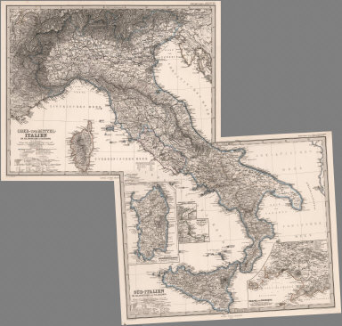
[Stieler, Adolf, Petermann, A.]
Full Title
(Composite of) Stieler's Hand-Atlas ... Italien.
List No
0960.108
Author
Stieler, Adolf, 1775–1836
Full Title
Italien. Von A. Petermann. Gezeichnet von H. Habenicht. Gestochen von C. Stier u. H. Stichart. Stieler's Hand-Atlas No. 30. Gotha: Justus Perthes 1875.
List No
13563.038
Note
Outline color map of Italy. With 3 insets: Rom und die Campagna. Turin und umgebung. Der Etna und Seine umgebung.
Author
Stieler, Adolf, 1775–1836
Full Title
Ober-Und Mittel-Italien. Von A. Petermann. Gez. von H. Habenicht. Gest. v. A. Hanemann, Terrain v. C. Jungmann. Stieler's Hand-Atlas No. 31. Gotha: Justus Perthes 1875.
List No
13563.039
Note
Outline color map of Northern and Central Italy. Includes Corsica.
Author
Stieler, Adolf, 1775–1836
Full Title
Sud-Italien. Von A. Petermann. Gez. von H. Habenicht. Gest. v. A. Hanemann, Terrain v. C. Jungmann. Stieler's Hand-Atlas No. 32. Gotha: Justus Perthes 1875.
List No
13563.040
Note
Outline color map of Southern and Central Italy. Includes 4 inset maps: Sardinia, Strait of Messina, Palermo and Naples.
Author
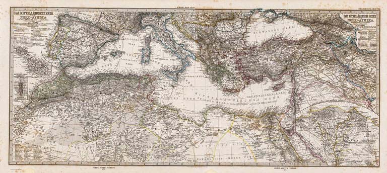
[Stieler, Adolf, Petermann, A.]
Full Title
Das Mittellandische Meer Und Nord-Afrika Im Maassstabe von 1:7.500.000. (Westliches Blatt.) Von A. Petermann. Gest. v. Poppey u. Jungmann. Gotha: Justus Perthes 1875.
List No
2449.012
Note
Outline color map of the Western Mediterranean, Southern Europe and Northern Africa. Two inset maps show Malta and Gibraltar.
Author
[Stieler, Adolf, Petermann, A.]
Full Title
(Composite of) Das Mittellandische Meer Und Nord-Afrika Im Maassstabe von 1:7.500.000. Von A. Petermann. Gest. v. Poppey u. Jungmann. Gotha: Justus Perthes 1875.
List No
2449.014
Note
Outline color map of the Mediterranean, Southern Europe and Northern Africa and Southwest Asia. Three inset maps show Malta, Gibraltar, and the Nile Delta and Isthmus of Suez.
Author
[Stieler, Adolf, Petermann, A.]
Full Title
Italien Im Maassstabe Von 1:3.700.000. Von A. Petermann. Gezeichnet von H. Habenicht. Gestochen von C. Stier u. H. Stichart. Gotha: Justus Perthes 1872.
List No
2449.031
Note
Italy in outline color with three inset maps: Rome and surrouding area, Turin, and Mt. Etna.
Author
[Stieler, Adolf, Petermann, A.]
Full Title
Ober-Und Mittel-Italien Im Maassstabe Von 1:1.850.000. Von A. Petermann. Gez. von H. Habenicht. Gest. v. A. Hanemann, Terrain v. C. Jungmann. Gotha: Justus Perthes 1874.
List No
2449.032
Note
Northern and middle Italy with Corsica in outline color.
Author
[Stieler, Adolf, Petermann, A.]
Full Title
Sud-Italien Im Maassstabe Von 1:1.850.000. Von A. Petermann. Gez. von H. Habenicht. Gest. v. A. Hanemann, Terrain v. C. Jungmann. Gotha: Justus Perthes 1874.
List No
2449.033
Note
Southern Italy and Sicily in outline color. Four inset maps included: Sardinia, Messina, Palermo and Naples.
Author
[Stieler, Adolf, Petermann, A.]
Full Title
Stieler's Hand-Atlas No. 30. Italien. (insets) Rom. Turin. Etna.
List No
2761.037
Author
[Stieler, Adolf, Petermann, A.]
Full Title
Stieler's Hand-Atlas No. 31. Ober-und Mittel-Italien.
List No
2761.038
Author
[Stieler, Adolf, Petermann, A.]
Full Title
Stieler's Hand-Atlas No. 32. Sud-Italien. (insets) Neapel und Umgegend. Sardinien. Palermo.
List No
2761.039
Author
[Stieler, Adolf, Petermann, A.]
Full Title
(Composite of) Stieler's Hand-Atlas No. 31, 32. Italien.
List No
2761.118
1-15 of 15
|