|
Author
(Oberkommando der Luftwaffe)
Full Title
Sudostkuste England : Schragbildreihe I : Dover - North Foreland. Ob.d.L. Fuhrungsstab Ic/Bild. Stand : Befestigungskarte vom 20.11.1940 ; Luftbild vom 2.9.1940. Ubersicht der Schrage Bildreihen sudostküste England sowie der verwendeten blatter 1:50 000.
List No
11336.002
Note
A joined sheet of all aerial views and maps, part 1 (204, 211, 219, 226, 232, 237, 240, 245, 250, 257, 267, 273, 276, 280) of Schragbildreihe I: Dover - North Foreland.
Author
(Oberkommando der Luftwaffe)
Full Title
Sudostkuste England : Schragbildreihe II : Dungeness - Dover. Ob.d.L. Fuhrungsstab Ic/Bild. Stand : Befestigungskarte vom 20.11.1940 ; Luftbild vom 1.9.1940. Ubersicht der Schrage Bildreihen sudostküste England sowie der verwendeten blatter 1:50 000.
List No
11336.004
Note
A joined sheet of all aerial views and maps, part 2 ( 8, 11, 14, 16,18, 20, 22, 24, 26, 28, 30, 32, 35, 38, 41, 44, 46, 48, 50, 53, 56, 59, 61, 63, 65, 67, 68, 69) of Schragbildreihe II : Dungeness - Dover.
Author
(Oberkommando der Luftwaffe)
Full Title
Sudostkuste England : Schragbildreihe III: Eastbourne - Dungeness. Ob.d.L. Fuhrungsstab Ic/Bild. Stand : Befestigungskarte vom 20.11.1940 ; Luftbild vom 1.9.1940. Ubersicht der Schrage Bildreihen sudostküste England sowie der verwendeten blatter 1:50 000.
List No
11336.006
Note
A joined sheet of all aerial views and maps, part 3 (84, 85, 87, 89, 91, 93, 95, 97, 99, 101, 103, 105, 108, 111, 114, 117, 120, 123, 126, 129, 132, 137, 141, 145, 148, 151, 153, 155, 157, 160, 162, 165, 168, 171, 174, 179).
Author
(Oberkommando der Luftwaffe)
Full Title
Sudostkuste England : Schragbildreihe IV: Selsey - Ostw. Seaford. Ob.d.L. Fuhrungsstab Ic/Bild. Stand : Befestigungskarte vom 20.11.1940 ; Luftbild (6-91) v. 5.9.1940. Luftbild (125-138) v. 27.9.1940. Ubersicht der Schrage Bildreihen sudostküste England sowie der verwendeten blatter 1:50 000.
List No
11336.008
Note
A joined sheet of all aerial views and maps, part 4 (6, 9, 11, 13, 15, 17, 19, 22, 26, 30, 35, 39, 43, 46, 50, 53, 56, 59, 62, 65, 68, 71, 75, 79, 82, 85, 88, 91, 125, 127, 129, 131, 132, 133, 134, 135, 136, 137, 138).
Author
Taylor, C. O.
Full Title
(Map of Stanford University and surroundings). C. O. Taylor.
List No
13254.000
Note
Blueprint view of the lands of the Leland Stanford Jr. University, City of Palo Alto and Estate of Timothy Hopkins. Printed on blue paper. Shows various buildings, orchards, roads and sport facilities. An early view of the campus without Hoover Tower and other building additions that came later. Title supplied by cataloger. Date estimated.
Author
Dittmar, W. J.
Full Title
The Road from Earth to Heaven. W. J. Dittmar.
List No
13172.000
Note
Pictorial map in black and orange brown tone by W. J. Dittmar, An illustrator of Ragtime music sheets in the early 20th century. First published in 1932 in black and white for the Union Gospel Press. Depicts road through life which is portrayed as a theme park: people arriving at the entrance (lower left) in buses, cars or on foot (on in the case of the Speed Mad in the wreckage of a car) with the ultimate destination being the plane trip from Heaven's Station to Eternity With The Lord. Most of the arrivals are sucked up in the glittering Pit or the inviting entrance "Do the Best You Can. An Easy Way." Many of those traveling further find themselves dumped into the River of Failures by stops at "Friendly Card Game" and the "Social Glass" or loitering at the "Mutual Admiration Society" to mention just a couple of the trials along the way.
Author
Redjinski
Full Title
Boston. Redjeinski 1977.
List No
13107.000
Note
Pictorial map of the neighborhoods within the city limits of Boston. Shows buildings, landmarks, parks, markets, etc.
Author
Anonymous
Full Title
Despues de tres anos de victorias Septiembre 1939 - Septiembre 1942. WPr / IV. E - Nr. 24-IX / 1942-Er.
List No
11808.000
Note
German propaganda map of the world in Spanish, celebrating the German and Japanese success in World War II from September 1939 to September 1942 after 3 victorious years and their role as the Liberators of the new young vibrant peoples of Europe and Asia. The map illustrates the dual assaults of Germany and Japan in the eastern and western theaters. Includes 2 insets, explanatory text and legend describing the conventional signs.
Author
Turpin, Edward A.
Full Title
A pictorial history of seafaring and meteorological chart of the sea for mariners and others interested in famous ships, lonely islands, lost treasures and the wonders of the deep. Drawn and copyrighted by Edward A. Turpin.
List No
11682.000
Note
Black and white pictorial map of the oceans, depicts a globe surrounded by historical and allegorical annotations. Map includes numerous annotations, decorative title cartouche, and illustrations of sun and the moon above the map.
Author
Allard, Carel, 1648-1709
Full Title
Planisphaerium terrestre, sive terrarum orbis, planisphaericè constructi repraesentatio quintuplex : adjunctis aliquibus astronomicae geographiae tyrociniis. Auctore Carolo Allard, Amstelo-Batavo = Vlakke aard-kloot, gemeenlyk genaamd de geheele waereld, vysvoudiglyk in vlakke ronden verbeeld : mitsgaders eenige noodige ontwerpen des sterrekundigen aard-beschryvings : Door Carel Allard, tot Amsterdam.
List No
11606.000
Note
One of the earliest multiple hemispheric maps of the world, surrounded by 12 insets, eight smaller projections depicting the world from various orientations, and four smaller circular diagrams of hemispheric projections. Shows California as an Island, "Terra Esonis" stretching between North America and Asia, partial coastlines for New Zealand and Australia together with the coastlines of "Carpentaria" and "Quiri Regio". Allard's innovative scientific style was copied by a number of other mapmakers, including Schenk, Zurner, Homann and Seutter, replacing the traditional baroque ornamentation of the late Dutch period. The dark cross-hatched engraved background provides a striking contrast to the engraved maps. Includes two title cartouches, one in Latin with the other in Dutch.
Author
Anonymous
Full Title
Vue de Paris du haut du Pavillon de Flore aux Tuileries.
List No
11540.000
Note
Copper engraving circular map panoramic view of Paris from the top of Pavillon de Flore. Includes most important landmarks and buildings, river, mountains and bridges. Date estimated based on number 34: Quai d'Orsay on the map is named Quai Bonaparte. the quay was only called Bonaparte between 1808-1815. Includes a key showing the areas depicted by the map.
Author
[Eschwege, Wilhelm Ludwig von, Martius, Karl Friedrich Philipp von]
Full Title
(Composite map of) Karte von Ost-Brasilien. Carte geographique de la partie orientale de l'empire du Bresil, en quatre Feuilles : contenant les provinces maritimes de Pernambuco jusqua Rio de Janeiro, celle de Minas Geraes, et une partie des provinces limitrophes, redigee d'apres leures propres observations et les cartes les plus exactes, et dediee A S.M. Don Pedro Empereur du Breso; par Guill de Eschwege et Ch. F. Ph. de Martius; dressee par I. Schwarzmann. Munich 1831. (insets) Les environs de Villa Rica. (with) Les environs de Rio de Janeiro. (with) Bahia do Rio de Janeiro.
List No
11292.005
Note
Composite of the sheets (1 - 4) of the map of eastern Brazil. Title on sheet 1. Relief shown by shading and spot heights. Shows rivers, cities and towns. Includes abbreviations and explanations of symbols. Title in French and German. Insets on sheet 4.
Author
[Newport, California, Smith, W. Alpheus]
Full Title
California Map Showing San Francisco, Newport. And Rail Road Connections With The Adjacent Country. Drawn by W. Alpheus Smith. T.R. Holland Lith. Boston. Plan & Location of the City of Newport, California, the terminus of the Great Pacific Rail-Road, a few homestead & building lots to be distributed free. for particulars enquire of the Agnet. (inset) Plan of Newport, California. (with: A Deed for lot 37 in Block 392 in the City of Newport to William H. Carr, of Mount Vernon, Kennebec County, State of Maine).
List No
4099.002
Note
Map without color. Shows cities and towns, with detailed plan of Newport city, city blocks, roads, railroads, etc. Relief shown by hachures. Map published separately to complement the Deeds.
Author
[Seutter, Matthaeus, 1678-1756, Rogg, Gottfried, 1669-1742]
Full Title
Accurata delineatio celeberrimae Regionis Ludovicianae vel Gallice Louisiane ol. Canadae et Floridae Adpellatione in Septemtrionali America Descriptae quae Hodie Nomine Fluminis Mississippi vel St. Louis . . . edita cura et manu Matthaei Seutteri, Chalcog. Augustan. ; Gottfr. Rogg, del. M. Rhein, sc.(inset) "Les costes de la Louisiane depuis la baye de Ascension jusques acelle de S. Joseph.
List No
8155.000
Note
Hand colored map of Seutter's Mississippi Bubble map, depicting the short-lived French financial-colonial scheme masterminded by Scottish financier John Law. Map shows early eighteenth century geography, settlements, and territories in North America focusing on the Mississippi River and the Great Lakes. Relief shown pictorially. Includes historical notes and distant chart. A large inset of the Gulf Coast shows many forts and Indian villages. Elaborate title cartouche, depicts an allegorical, satirical scene of the infamous Mississippi Bubble investment scheme with a female personification of the Mississippi River pouring jewels and riches forth, while she is perched precariously upon a bubble. Cherubs above the cartouche are issuing stock for the company, and another group is blowing bubbles in the foreground surrounded by piles of worthless stocks. In the background, desperate investors climb a small tree and fling themselves out of it, and in the foreground more disconsolate investors wail and bemoan their fates as one tries to impale himself on his sword. Above them, a cherub upends an empty money-bag.
Author
Gallatin, Albert
Full Title
Carte des Tribus Indiennnes de l'Amerique du Nord : vers 1600 A.D. ;e long de l'Atlantique ; et vers 1800 A.D. a l'Ouest. D'apres un dessin Mr. Gallatin.
List No
6749.000
Note
Map of the Indian Tribes of North America about 1600 A.D. along the Atlantic; & about 1800 A.D. westwardly. This edition is identical to the American edition of Gallatin map (see: Rumsey Historical Map Collection #3388.000), published by the American Antiquarian Society in their Archaeologia Americana, 1838, except for the addition of an area in the middle of map with a double broken line, showing Indian Territory in Oklahoma. "Le Terrotoire definitivement attribue aux Indiens, est indique par le double trail noir pointle." Map is hand colored. Includes color code listing of Indian territories and tribes, rivers, mountains, place names and notes. Great Basin is called "Sandy Desert". Shows J. Smith exploration routes of 1826 and 1827 across the Great Basin. Date estimated.
Author
Williams, Robert
Full Title
The Mystery Map of Assinine Atoll. (c)opyright Robert Williams, 77.
List No
6869.000
Note
Black and White pictorial map. Created in 1977 by Williams and used in Zap Comix #9, 10th Anniversary Issue, Sept. 1978. In respect of Williams' copyright, viewing only is allowed. To purchase art by Williams go to http://robtwilliamsstudio.com
Author
Cook, James
Full Title
A Map of the Province of South Carolina with all the Rivers, Creeks, Bays, Inletts, Islands, Inland Navigation, Soundings, Time of High Water on the Sea Coast, Roads, Marshes, Ferrys, Bridges, Swamps, Parishes Churches, Towns, Townships; Country Parish District and Provincial Lines. Humbly inscribed to the Hon.ble Lawlins Lownds Esqr. Speaker & the rest of the Members of the Hon.ble the Commons House of Assembly of the Province by their most Obedt. & faithfull Servt Jams Cook. Thos. Bowen, sculpt. 1773. (with 6 inset maps).
List No
5174.000
Note
The maker of this map, James Cook, surveyor of South Carolina and former marine surveyor, is not to be confused with the Pacific explorer, Captain James Cook. In 1770, James Cook was commissioned by the South Carolina provincial government to make a new survey of the entire province and publish a map, which he completed in 1773. Cummings refers to the map as "the most detailed and accurate printed map of South Carolina, especially for the interior, yet to appear" and further states that "very few copies of this fine map are extant." It provided much of the detail for the later maps by Henry Mouzon and John Stuart. Sellers and Van Ee call it "one of the most important maps in the cartography of the state until the early nineteenth century." It is excessively rare, with only five copies identified in United States institutions, and one in the British Museum. There are two states of this first and only issue, distinguished by the presence in the second state of an additional imprint "Publish'd according to Act of Parliament July 7th. 1773 and Sold by H. Parker in Cornhill" under the neat line. This copy is the first state, with two of the other six copies being first state as well. There are six inset maps: Beaufort, Camden, Georgetown, Port Royal, Charles Town, and Harbour of Charles Town. The main map is very detailed, showing land owners in profusion. Along the coast are many navigation notes, indicative of Cook's maritime background. This appears to have been Cook's only major map production; his other work is limited to three harbor charts published in 1766 (illustrated by Black): A Draught of Port Royal Harbour (similar to the Port Royal inset map on the South Carolina 1773), A Draught of the Harbour of Halifax, and A Draught of West Florida.
Author
Anonymous
Full Title
United States.
List No
5442.000
Note
Outline color hand drawn map by a young student. A silk blue border has been sown onto map with silk hooks for hanging. Date estimated from geography of the west.
Author
Schmitt, Paul A.
Full Title
Map of Mills College. Paul A. Schmitt.
List No
11188.000
Note
Bird's-eye-view pictorial map of the Mills College campus in Oakland, California, by Paul A. Schmitt. Date estimated. Shows street, various buildings, wooded areas, etc. There are three vignette illustrations: Lake Aliso, Art Gallery and Gold Hollow; plus an inset map in upper left corner "Our College World" showing the San Francisco Bay Area. In a charming touch. Includes decorative compass at the right and portraits of Cyrus Taggart Mills and Susan Tolman Mills at lower edge. An arrow leading out of the picture at the lower edge is marked "Remember Who You Are." "Enter to search for truth in joyous study - depart to use in life the truth here found"
Author
Drevenstedt, Amy
Full Title
The Flight of Charles A. Lindbergh from New York to Paris in his Mono Plane "The Spirit Of St. Louis" on May 20-21, 1927. (illustrated by) Amy Drevenstedt.
List No
11198.000
Note
Pictorial map of North America and Western Europe showing Charles Lindbergh’s famous and epic Transatlantic flight from New York across the Atlantic Ocean to Paris in a plane dubbed The Spirit of St. Louis. Library has colored and larger version of the map, see #8252.000. The left border depicts the preparations including the initial flight from San Diego to St. Louis and on to New York. The upper border illustrates the elements he braved: "Distance, Fog, Snow, Sleet, Darkness and Solitude.” The right border illustrates his destination including the airport in France and the triumphant reception in Paris and Brussels. The lower border depicts his return via the USS Memphis to a hero's greeting in Washington and New York. Relief shown by hachers.
Author
[Eschwege, Wilhelm Ludwig von, Martius, Karl Friedrich Philipp von]
Full Title
Karte von Ost-Brasilien. Carte geographique de la partie orientale de l'empire du Bresil, en quatre Feuilles : contenant les provinces maritimes de Pernambuco jusqua Rio de Janeiro, celle de Minas Geraes, et une partie des provinces limitrophes, redigee d'apres leures propres observations et les cartes les plus exactes, et dediee A S.M. Don Pedro Empereur du Breso; par Guill de Eschwege et Ch. F. Ph. de Martius; dressee par I. Schwarzmann. Munich 1831. (insets) Les environs de Villa Rica. (with) Les environs de Rio de Janeiro. (with) Bahia do Rio de Janeiro.
List No
11292.001
Note
1 map of eastern Brazil on 4 sheets, 97x86. Sheets 70x52. Title on sheet 1. Relief shown by shading and spot heights. Shows rivers, cities and towns. Includes abbreviations and explanations of symbols. Title in French and German. Insets on sheet 4.
Author
[Eschwege, Wilhelm Ludwig von, Martius, Karl Friedrich Philipp von]
Full Title
Karte von Ost-Brasilien. Carte geographique de la partie orientale de l'empire du Bresil, en quatre Feuilles : contenant les provinces maritimes de Pernambuco jusqua Rio de Janeiro, celle de Minas Geraes, et une partie des provinces limitrophes, redigee d'apres leures propres observations et les cartes les plus exactes, et dediee A S.M. Don Pedro Empereur du Breso; par Guill de Eschwege et Ch. F. Ph. de Martius; dressee par I. Schwarzmann. Munich 1831. (insets) Les environs de Villa Rica. (with) Les environs de Rio de Janeiro. (with) Bahia do Rio de Janeiro.
List No
11292.002
Note
1 map of eastern Brazil on 4 sheets, 97x86. Sheets 70x52. Title on sheet 1. Relief shown by shading and spot heights. Shows rivers, cities and towns. Includes abbreviations and explanations of symbols. Title in French and German. Insets on sheet 4.
Author
[Eschwege, Wilhelm Ludwig von, Martius, Karl Friedrich Philipp von]
Full Title
Karte von Ost-Brasilien. Carte geographique de la partie orientale de l'empire du Bresil, en quatre Feuilles : contenant les provinces maritimes de Pernambuco jusqua Rio de Janeiro, celle de Minas Geraes, et une partie des provinces limitrophes, redigee d'apres leures propres observations et les cartes les plus exactes, et dediee A S.M. Don Pedro Empereur du Breso; par Guill de Eschwege et Ch. F. Ph. de Martius; dressee par I. Schwarzmann. Munich 1831. (insets) Les environs de Villa Rica. (with) Les environs de Rio de Janeiro. (with) Bahia do Rio de Janeiro.
List No
11292.003
Note
1 map of eastern Brazil on 4 sheets, 97x86. Sheets 70x52. Title on sheet 1. Relief shown by shading and spot heights. Shows rivers, cities and towns. Includes abbreviations and explanations of symbols. Title in French and German. Insets on sheet 4.
Author
[Eschwege, Wilhelm Ludwig von, Martius, Karl Friedrich Philipp von]
Full Title
Karte von Ost-Brasilien. Carte geographique de la partie orientale de l'empire du Bresil, en quatre Feuilles : contenant les provinces maritimes de Pernambuco jusqua Rio de Janeiro, celle de Minas Geraes, et une partie des provinces limitrophes, redigee d'apres leures propres observations et les cartes les plus exactes, et dediee A S.M. Don Pedro Empereur du Breso; par Guill de Eschwege et Ch. F. Ph. de Martius; dressee par I. Schwarzmann. Munich 1831. (insets) Les environs de Villa Rica. (with) Les environs de Rio de Janeiro. (with) Bahia do Rio de Janeiro.
List No
11292.004
Note
1 map of eastern Brazil on 4 sheets, 97x86. Sheets 70x52. Title on sheet 1. Relief shown by shading and spot heights. Shows rivers, cities and towns. Includes abbreviations and explanations of symbols. Title in French and German. Insets on sheet 4.
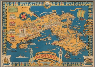
Author
Barter, Marjouri
Full Title
This is a souvenir map of Newport Rhode Island : Showing some of the principal estates and places of historic interest. By Marjorie Barter.
List No
11315.000
Note
Pictorial map of the city of Newport, Rhode Island by Marjorie Barter with decorative border and title cartouche. The map is richly illustrated with depiction of numerous individual vignettes of historical buildings, landmarks and scenes. Highlight important events. Shows place names, streets, railroads, parks, ships, sailboats, planes and points of interest. Includes decorative compass rose at upper left panel. and seal of the city of Newport at upper center. Date estimated.
Author
Wood, Stacy H.
Full Title
Boy Scouts of America jamboree, Washington, D.C., August 21-30, 1935. Stacy H. Wood - Siwanoy Council.
List No
11323.000
Note
Pictorial map of the United States on sheet 52.5x98. Designed for the 1935 25th. Anniversary of the Boy Scouts of America. Jubilee National Jamboree was scheduled for August 21 ��� 30, in Washington, DC. the Jamboree was canceled because of an outbreak of Polio and was rescheduled and held in the summer of 1937. Map show boy scouts in various activities, roads, railroads and mode of transportation, Includes views on left and right panels, notes and decorative compass rose on lower right corner.
Author
Schick., L.E.
Full Title
Map of West Point, New York (with variations). MCMXXVIII (1928). L E Schick. (inset) Popolopen.
List No
11484.000
Note
Pictorial map of West Point Military Academy, New York. Shows roads, railroads, buildings and landmarks. Relief shown pictorially. Includes title cartouche, decorative compass rose oriented with north toward the upper left.
Author
Jannot, J.B.
Full Title
Le Tour du Monde en 120 Images Grand Concours du Choca lat Menier. J.B. Jannot. (insets) Israel. (with) Inde. (with) Congo Belge.
List No
11485.000
Note
Pictorial map of the world, with decorative compass at the center of map. Promotional map for Menier Chocolate Company founded in 1816 as a pharmaceutical manufacturer in Paris, at the time when chocolate was used as a medicinal product. Map shows native people, wildlife, industry, major cities and sea creatures.
Author
Committee of Public Safety
Full Title
The World Cannot Live Half Slave, Half Free : The Prussian Blot. By authority of the Committee of Public Safety.
List No
11496.000
Note
Propaganda poster encouraging American involvement in World War I by depicting the Prussian army as enslaving Europe, on sheet 76x51. With no publisher. Date estimated. Includes a map of Europe with the land occupied by Germany in red, with text: "The Prussian Blot. 100,000,000 People Already Enslaved by Germany." At the bottom it reads: "While Germany Dreams of Dominating the World By Force, There Can Be No Peace."
Author
Anonymous
Full Title
(Korean Celestial and zodiacal constellation chart).
List No
11806.001
Note
Early manuscript star chart integrating Korean, Chinese, and western astronomical science, with title on verso, on sheet 85x81. Date estimated. Originally engraved in a stone stele. Showing rank and distribution of Stars, illustrates the traditional Chinese zodiacal system, following the Cheonsang Yeolcha Bunyajido, a fourteenth -centuray Korean star map, but also incorporating western zodiacal astrology, and Qian Lezhi's c. 440 AD Chinese celestial globe illustrating the work of the ancient Chinese astronomers Shi Shen, Gan De, and Wu Xian. Following Qian Lezhi's c. system the constellations of the three great astronomers are distinguished. Constellations appearing in black reference Gan De, constellations in red reference Shi Shen, open circles reference Wu Xia. Two larger intersecting circles surround the center, represent the ecliptic and Equator. The chart is further divided into numerous xiu, surrounding a central nexus. The nexus, represented by a circle at the center of the map, represents Earthly life. The other constellations are divided into zones typically referred to as xiu or mansions. In traditional Chinese celestial cartography there are 28 unequal mansions, presumably associated with lunar movements. This chart, for no clear reason, consolidates several of the smaller mansions into larger entities, leaving only 24. This chart also illustrates the Milky Way, a feature uncommon to Chinese charts, but not atypical on Korean charts from the 14th century onwards, when it first appeared on the Cheonsang Yeolcha Bunyajido. Around the outside of the map the constellations of the western Zodiac, and the seasons, are named. An exceptionally rare and important discovery.
Author
Anonymous
Full Title
(Title Page to) (Korean Celestial and zodiacal constellation chart).
List No
11806.002
Note
Early manuscript star chart integrating Korean, Chinese, and western astronomical science, with title on verso, on sheet 85x81. Date estimated. Originally engraved in a stone stele. Showing rank and distribution of Stars, illustrates the traditional Chinese zodiacal system, following the Cheonsang Yeolcha Bunyajido, a fourteenth -centuray Korean star map, but also incorporating western zodiacal astrology, and Qian Lezhi's c. 440 AD Chinese celestial globe illustrating the work of the ancient Chinese astronomers Shi Shen, Gan De, and Wu Xian. Following Qian Lezhi's c. system the constellations of the three great astronomers are distinguished. Constellations appearing in black reference Gan De, constellations in red reference Shi Shen, open circles reference Wu Xia. Two larger intersecting circles surround the center, represent the ecliptic and Equator. The chart is further divided into numerous xiu, surrounding a central nexus. The nexus, represented by a circle at the center of the map, represents Earthly life. The other constellations are divided into zones typically referred to as xiu or mansions. In traditional Chinese celestial cartography there are 28 unequal mansions, presumably associated with lunar movements. This chart, for no clear reason, consolidates several of the smaller mansions into larger entities, leaving only 24. This chart also illustrates the Milky Way, a feature uncommon to Chinese charts, but not atypical on Korean charts from the 14th century onwards, when it first appeared on the Cheonsang Yeolcha Bunyajido. Around the outside of the map the constellations of the western Zodiac, and the seasons, are named. An exceptionally rare and important discovery.
Author
Anonymous
Full Title
Birthplace of great composers. O. W. J.
List No
11948.000
Note
Pictorial hand colored map by country, with no publisher and publication date. Covers North America, and Europe, covers portion of Asia Africa, South America and Australia. With music scores at its borders, title cartouche and numerous illustrations of animals, people, ships and sea monsters. Includes decorative compass roses. singed by O.W.J. at the right lower corner. Date estimated.
Author
Anonymous
Full Title
(Coves to) Map of Doniphan County, Kansas. Showing the location of Highland.
List No
13037.001
Note
Map of Highland and neighboring towns, in Doniphan county, Kansas, Folds into a manuscript cover page document with three signatures, concerning the drawing of lots to be awarded to the various share holders that held stock in the town. Includes an embossed stamp from Highland University, established for the Sac and Fox National Indian Tribe in 1837.
Author
Anonymous
Full Title
Map of Doniphan County, Kansas. Showing the location of Highland.
List No
13037.002
Note
Map of Highland and neighboring towns, in Doniphan county, Kansas, Folds into a manuscript cover page document with three signatures, concerning the drawing of lots to be awarded to the various share holders that held stock in the town. Includes an embossed stamp from Highland University, established for the Sac and Fox National Indian Tribe in 1837.
Author
Rankin, J. T.
Full Title
The popular wireless broadcasting map of the world. J. T. Rankin cartographer.
List No
13108.000
Note
Map of the world in Mercator projection. Showing ordinary broadcasting stations, ordinary and short wave stations, short wave stations and television stations. Includes 9 insets showing location of broadcasting stations in major cities around the world. Date estimated.
Author
Escalante, Ernesto
Full Title
Nuevo plano de la ciudad de Buenos Aires y parte del partido de Avellaneda. Dibujado por Ernesto Escalante.
List No
13275.000
Note
Colored map. Showing street names, public buildings, city blocks, markets, churches, hospitals, parks and railways. Includes name of the neighborhood and color coded legend. .
Author
Williamson, R.S.
Full Title
Military Map of the South Eastern Part of Oregon, South Western Part of Idaho, North Eastern Part of California, and Northern Part of Nevada. North Eastern Part of California & South Eastern Part of Oregon Made from actual Surveys by Lt. Col. Drew and Lt. Col. Williamson, the other parts compiled from other reliable sources. 1866.
List No
1464.000
Note
1 map on 6 sheets. Full size photo reproduction of original in Bancroft Library. First detailed map of the Owyhee country and the area of Northeastern Nevada. Britton and Rey map of the same year taken from this and Wheat 1160. Relief shown by form lines. Shows drainage, and roads.
Author
Knight, Edward H.
Full Title
Map Of The Country Tributary To The Northern Pacific Railroad. Compiled from English, Canadian, and American official sources and original Surveys by Edward H. Knight. Jan. 1st. 1871. The compilation of English and Canadian charts and Surveys embracing the Northerly region of this Map, was platted in connection with the official U.S. War Department Map (the lower portion) at the Bureau of U.S. Topographical Engineers by the kind permission of Maj. Gen. A.A. Humphreys. (with profile).
List No
3571.000
Note
A spectacular map, missed by Wheat. With full and outline color. Shows the route of the proposed Northern Pacific Railroad. Covers the entire U.S. and Canada west of the Mississippi, and south to the 38th parallel. One immediately recognizes the use of the Warren/Freyhold "Map of the Territory of the United States..." of 1868, for the lower portion of this map - it is an exact copy. The upper portion appears to be a copy of some official English and/or Canadian survey map. Isothermal lines, railroad routes, latitudes of major European Cities, Distances to Asia, Coal fields, and notes about usability of the soil and forests are added. A profile shows the "Difference Between The Elevations of the Northern Pacific and the Union Pacific Railroads." Relif shown by hachures.
Author
Ellicott, Joseph & B.
Full Title
Map of Morris's Purchase or West Geneseo In the State of New York. Exhibiting Part of the Lakes Erie and Ontario, the Straights of Niagara, Chautauque Lake and all the principal Waters, the Boundary lines of the several Tracts of Land purchase by the Holland Land Company, William and John Willink and others ... by Joseph & B. Ellicott 1800. To The Holland Land company their General Agents Theophilus Cazenove & Paul Bush Esquires, This Map Is respectfully inscribed by the Authors. 1804.
List No
3712.000
Note
1st edition was 1800. Vail says this was the "Most important map of the Holland Land Company, published for the promotion of sale of their Western New York lands." Nestler calls it "Probably the most important map of western NY when Buffalo was still known as New Amsterdam, and when land companies were luring settlers to this new frontier." The map is highly detailed, showing every tributary of every tributary of every stream. All the township and range lines are laid down, every town located, all reservations shown and all roads indicated. One has the impression that the ground was expertly surveyed with care and diligence. The Holland land holding comprised well over three million acres, not a modest subdivision! Ellicott was the company's agent at Batavia for many years. Map is without color.
Author
Allardt, G. F.
Full Title
Sale map no. 12. Salt marsh and tide lands situate in the city and county of San Francisco, state of California. To be sold at public auction by order of the Board of Tide Land Commissioners ... at the sales rooms of Greenebaum & Co., auctioneers, nos. 115 & 117 Bush Street, San Francisco. Sale to commence Tuesday, March 4th, 1873. R.P. Johnson, Edgar Briggs, C.M. Stratton, Board of Tide Land Commissioners. J.M. Currier, Secretary. G.F. Allardt, Chief Engineer.
List No
3971.000
Note
Another tide lands sale map, this one showing two separate areas titled "Salt Marsh and Tide Lands at North Beach" and "Salt Marsh and Tide Lands Along Mission Creek and Mission Bay." Shows drainage, block and lot numbers, etc. Covers area bounded generally by Mission, 20th, Mississippi, and Channel Streets; covers area bounded by the Bay, Webster and Lombard Streets, and the Presidio. Cadastral maps. Scale of 2nd map 1:6,000.
Author
Newport, California
Full Title
(Cover and Deed to) California Map Showing San Francisco, Newport. Rail Road Connections With The Adjacent Country. (with: A Deed for lot 37 in Block 392 in the City of Newport to William H. Carr, of Mount Vernon, Kennebec County, State of Maine).
List No
4099A
Note
Large text page includes a 50 cent hand canceled stamp.
Author
Newport, California
Full Title
California Map Showing San Francisco, Newport. Rail Road Connections With The Adjacent Country. (with: A Deed for lot 37 in Block 392 in the City of Newport to William H. Carr, of Mount Vernon, Kennebec County, State of Maine).
List No
4099.001
Note
Map without color. This side includes the seal of the Commissioner of Deeds.
Author
[Smyth, Newton V.V., Drury, R.L.]
Full Title
Map of The City Of Santa Rosa And Vicinity, Sonoma Co., Cal. Compiled From Maps Of Record, Private Maps And Actual Surveys, By Newton V.V. Smyth, City Engineer. Drawn by R.L. Drury. Copyright 1896 by Newton V.V. Smyth (inset) Map showing The Relative Position Of Santa Rosa To The Bay Of San Francisco and its Railroad Facilities. (with 2 additional inset maps).
List No
4771.000
Note
Scarce, detailed map of Santa Rosa showing the rapid subdivision growth at the turn of the century. Not in any references. With an inset map of "The Relative Position of Santa Rosa To The Bay of San Francisco..." of which a portion is missing. Two smaller inset maps are titled: "Plat of Bogart's Sub's ..." and "Plat showing Portion Of City Covered By Fire Limits." In printed color, on thin paper. Portions of this map appear, with credit to Smyth, in Reynolds and Proctor's "Illustrated Atlas of Sonoma County," 1898 (see our copy). Full color.
Author
Renault, Jn. F.
Full Title
Plan of York Town In Virginia And Adjacent Country. Exhibiting the operations of the American French & English armies, during the siege at that place in Oct. 1781. Surveyed from the 22nd to the 28th Octr. Drawn by Jn. F. Renault, with a Crow-pen and presented to the Marques De La Fayette. Engraved by B. Tanner.
List No
5331.000
Note
This is a engraved copy of the original 1782 map of Yorktown by Sebastian Bauman. This copy was made in 1825 and presented to Lafayette on the occasion of his visit to America. The map is not dated, and we have taken the (1825) date from Fite and Freeman. Map is without color.
Author
Lewis, Samuel
Full Title
A New Map Of The Seat Of War. S. Lewis. del. J. Bower, Sct. (with inset map) Niagara River.
List No
5433.000
Note
Outlined hand colored map on linen. Date estimated.
Author
Norton, Lott Day
Full Title
Map of the city of Merced : and subdivisions of adjoining acreage property, Merced Co. Cal. on line of Visalia Division Central Pacific Railroad. Sec's. 24 & 25, T. 7 S.R. 13 E. Sec's. 19 & 30, T. 7 S.R. 14 E. Resurveyed June 1897 By L.D. Norton.
List No
8011.000
Note
Highly detailed blue print map of Merced, California, prepared for the Pacific Improvement Company. Primarily an agricultural region, ideally located to provide transportation of the crops. Bounded at the north by an irrigating canal which follows the course of Bear Creek. The land reserved for the railroad shown in the center of town. Shows lot and block numbers, lot sizes, tracts, streets, railroad, major public buildings. Includes location map.
Author
Sarg, Tony (1880-1942)
Full Title
Residential Main St. Nantucket Mass. Designed by Tony Sarg. 1937.
List No
8074.000
Note
Pictorial map, bird's eye view style, uncolored. By illustrator and puppeteer Tony Sarg, and this is his affectionate map of the central streets, documenting the history of this whaling town. With a list of important public and residential buildings. Includes vignette illustrations in the border of outstanding citizens. Title framed with decorative illustrations.
Author
DeFoy, Francis
Full Title
San Francisco city of thousand and one delights. Copyright, 1936 Francis DeFoy. Litho. in U.S.A. Golden Gate International Exposition of 1939: Pageant of the Pacific.
List No
8104.000
Note
Pictorial map. Shows the Golden Gate International Exposition 1939 on Treasure Island, Oakland-San Francisco Bay Bridge Terminal, major buildings and land marks, street cars, modes of transportation to the exposition site, parks, etc. Relief shown pictorially.
Author
Eckhard, Walter
Full Title
Philips Radio. (by) Eckhard. (on lower right margin) R A 556.
List No
8110.000
Note
Pictorial map of the world's international short wave radio stations by Philips Radio, mounted on heavy paper and linen. Radio stations shown in red circle. Small drawings throughout represent genre scenes depicting the people, plants and animals. Date estimated. Title inset showing radio stations on outline map of the world. Includes detailed index to the stations on the lower margin and compass rose shown on the lower left.
Author
Oauss, Edward
Full Title
Seven-Five-Zero Tank Battalion. Cpl. Edward Oauss. Germany, June 15, 1945. "Was supported at various times by the following... Ninth US Army, First Canadian army, First US Army, III US Corps ...
List No
8171.000
Note
Humorous pictorial map, colored in red, blue and green. Germany shown in yellow in the center of map. The Seven-Five-Zero Tank Battalion, as it came to be called, spent over 180 days in combat in Europe during World War II. Shows battle field campaigns in Rhineland, Ardennes-Alsace, Central Europe. Filled with drawings of soldiers, buildings and locations, with explanatory text, dates and quotations related to historical events in the battle field. Includes 750 tank battalion emblems and list of commanding officers. Relief shown pictorially.
|