|
REFINE
Browse All : Images by Newberry, J.S.
1-28 of 28
Author
Ives, J.C.
Full Title
Geological Map No. 1. Prepared by J.S. Newberry, M.D. Geologist to the Expedition. Explorations and Surveys. War Department. Map No. 1. Rio Colorado of the West, explored by 1st Lieut. Joseph C. Ives, Topl. Engrs. under the direction of the Office of Explorations and Surveys. A.A. Humphreys, Capt. Topl. Engrs. in Charge, by order of the Hon. John B. Floyd, Secretary of War. 1858. Drawn by Frhr. F.W.v. Egloffstein. Topographer to the Expedition. Topography by Frhr. F.W.v. Egloffstein. Ruling by Samuel Sartain. Lettering by F. Courtenay.
List No
0341.003
Note
Color washed map in four parts across the page with the title on the far right map, with the maps reading from right to left. The detail of the map is superb, and shows the course of the Colorado River from its headwaters to the Gulf of California.
Author
Ives, J.C.
Full Title
Geological Map No. 2. Prepared by J.S. Newberry, M.D. Geologist to the Expedition. Explorations and Surveys. War Department. Map No. 1. Rio Colorado of the West, explored by 1st Lieut. Joseph C. Ives, Topl. Engrs. under the direction of the Office of Explorations and Surveys. A.A. Humphreys, Capt. Topl. Engrs. in Charge, by order of the Hon. John B. Floyd, Secretary of War. 1858. Drawn by Frhr. F.W.v. Egloffstein. Topographer to the Expedition. Topography by Frhr. F.W.v. Egloffstein. Ruling by Samuel Sartain. Lettering by F. Courtenay.
List No
0341.004
Note
Color washed map showing the Grand Canyon in superb detail with geological information included. A key is added below the map. The "line of exploration" and camps are shown.
Author
[Macomb, J.N., Newberry, J.S.]
Full Title
(View) Trap Dyke, Pope's Well, S. of Santa Fe, New Mexico. J.S.N. T. Sinclair & Son. lith. Phila.
List No
2699.004
Note
Black and white lithograph.
Author
[Macomb, J.N., Newberry, J.S.]
Full Title
(View) Plate I. Abiquiu Peak, Looking Westerly. J.J. Young from a sketch by Dr. J.S. Newberry. T. Sinclair & Son. lith. Phila.
List No
2699.005
Note
Color lithograph.
Author
[Macomb, J.N., Newberry, J.S.]
Full Title
(View) Plate II. Near Vado Del Chama, Upper Cretaceous Mesa. J.J. Young from a sketch by Dr. J.S. Newberry. T. Sinclair & Son. lith. Phila.
List No
2699.006
Note
Color lithograph.
Author
[Macomb, J.N., Newberry, J.S.]
Full Title
(View) The Pagosa, S.W. Colorado, San Juan Exped. J.S.N. T. Sinclair & Son. lith. Phila.
List No
2699.007
Note
Black and white lithograph.
Author
[Macomb, J.N., Newberry, J.S.]
Full Title
(View) Plate IV. The Pagosa & San Juan River, Looking Easterly. J.J. Young from a sketch by Dr. J.S. Newberry J.S.N. T. Sinclair & Son. lith. Phila.
List No
2699.008
Note
Color lithograph.
Author
[Macomb, J.N., Newberry, J.S.]
Full Title
(View) Plate III. La Piedra Parada, Looking West. J.J. Young from a sketch by Dr. J.S. Newberry. T. Sinclair & Son. lith. Phila.
List No
2699.009
Note
Color lithograph. This plate located after Plate IV in bound volume.
Author
[Macomb, J.N., Newberry, J.S.]
Full Title
(View) Plate V. Rio Dolores & Sierra de la Plata, from near Camp 21. J.J. Young from a sketch by Dr. J.S. Newberry. T. Sinclair & Son. lith. Phila.
List No
2699.010
Note
Color lithograph.
Author
[Macomb, J.N., Newberry, J.S.]
Full Title
(View) Plate VI. Casa Colorado & La Sal-Mountains. Looking Northerly. J.J. Young from a sketch by Dr. J.S. Newberry. T. Sinclair & Son. lith. Phila.
List No
2699.011
Note
Color lithograph.
Author
[Macomb, J.N., Newberry, J.S.]
Full Title
(View) Ruins of Stone Houses Cliffs, Labyrinth Canyon. J.S.N. T. Sinclair & Son. lith. Phila.
List No
2699.012
Note
Black and white lithograph.
Author
[Macomb, J.N., Newberry, J.S.]
Full Title
(View) Plate VII. Head of Labyrinth Creek. Looking South-Easterly. J.J. Young from a sketch by Dr. J.S. Newberry. T. Sinclair & Son. lith. Phila.
List No
2699.013
Note
Color lithograph.
Author
[Macomb, J.N., Newberry, J.S.]
Full Title
(View) Plate VIII. Head of Canon (Canyon), Colorado, Erosion of Triassic Series. J.J. Young from a sketch by Dr. J.S. Newberry. T. Sinclair & Son. lith. Phila.
List No
2699.014
Note
Color lithograph.
Author
[Macomb, J.N., Newberry, J.S.]
Full Title
(View) Plate IX. Lower San Juan, Looking West from Near Camp 35. J.J. Young from a sketch by Dr. J.S. Newberry. T. Sinclair & Son. lith. Phila.
List No
2699.015
Note
Color lithograph.
Author
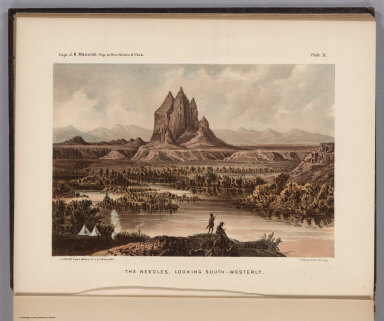
[Macomb, J.N., Newberry, J.S.]
Full Title
(View) Plate X. The Needles, Looking South-Westerly. J.J. Young from a sketch by Dr. J.S. Newberry. T. Sinclair & Son. lith. Phila.
List No
2699.016
Note
Color lithograph.
Author
[Macomb, J.N., Newberry, J.S.]
Full Title
(View) Plate XI. The Cabazon from near Camp 54. J.J. Young from a sketch by Dr. J.S. Newberry. T. Sinclair & Son. lith. Phila.
List No
2699.017
Note
Color lithograph.
Author
[Macomb, J.N., Newberry, J.S.]
Full Title
(Text and View) Plate I. Cretaceous Fossils. Paleotology of Capt. Macombs Expls. F.B. Meek, del. T. Sinclair & Son. lith. Phila.
List No
2699.018
Note
Black and white lithograph.
Author
[Macomb, J.N., Newberry, J.S.]
Full Title
(Text and View) Plate II. Cretaceous Fossils. Paleotology of Capt. Macombs Expls. F.B. Meek, del. T. Sinclair & Son. lith. Phila.
List No
2699.019
Note
Black and white lithograph.
Author
[Macomb, J.N., Newberry, J.S.]
Full Title
(Text and View) Plate III. Carboniferous & Cretaceous Fossils. Paleotology of Capt. Macombs Expls. T.Y. Gardner, del. T. Sinclair & Son. lith. Phila.
List No
2699.020
Note
Black and white lithograph.
Author
[Macomb, J.N., Newberry, J.S.]
Full Title
(Text and View) Plate IV. (Carboniferous & Cretaceous Fossils). Capt. Macomb Expl. in New Mexico & Utah. T. Sinclair & Son. lith. Phila.
List No
2699.021
Note
Black and white lithograph.
Author
[Macomb, J.N., Newberry, J.S.]
Full Title
(Text and View) Plate V. (Carboniferous & Cretaceous Fossils). Capt. Macomb, Expl. in New Mexico & Utah. T. Sinclair & Son. lith. Phila.
List No
2699.022
Note
Black and white lithograph.
Author
[Macomb, J.N., Newberry, J.S.]
Full Title
(Text and View) Plate VI. (Carboniferous & Cretaceous Fossils). Capt. Macomb, Expl. in New Mexico & Utah. T. Sinclair & Son. lith. Phila.
List No
2699.023
Note
Black and white lithograph.
Author
[Macomb, J.N., Newberry, J.S.]
Full Title
(Text and View) Plate VII. (Carboniferous & Cretaceous Fossils). Capt. Macomb, Expl. in New Mexico & Utah. T. Sinclair & Son. lith. Phila.
List No
2699.024
Note
Black and white lithograph.
Author
[Macomb, J.N., Newberry, J.S.]
Full Title
(Text and View) Plate VIII. (Carboniferous & Cretaceous Fossils). Capt. Macomb, Expl. in New Mexico & Utah. T. Sinclair & Son. lith. Phila.
List No
2699.025
Note
Black and white lithograph.
Author
[Walling, Henry Francis, 1825-1888, Lloyd, H.H.]
Full Title
(Covers to) Atlas Of The State Of Ohio From Surveys under the Direction of H.F. Walling, To which is added An Atlas Of The United States. Published for Henry S. Stebbins By H.H. Lloyd & Co. 21 John Street, New York. 1868. (on verso) Entered ... 1868, By H.H. Lloyd & Co. ... New York.
List No
4726.001
Note
First edition. See 1872 edition by Walling and Gray. This has the mostly the same maps as the 1872 issue, but arranged differently with different groups of counties on the same sheet, and the city and thematic maps are changed. The Lloyd maps of the U.S. are also grouped differently, generally in larger groups, which make some impressive maps in the western U.S., and maps of Ohio and its counties, as well as 19 pages of historical and informational text, alphabetical index of maps and 2 pages of "List of post offices in Ohio." Maps are single or double page hand colored. Bound in half leather dark green cloth covered boards with "Atlas Of Ohio And The United States." gold stamped on the front cover, and blind stamped on the back.
Author
[Walling, Henry Francis, 1825-1888, Lloyd, H.H.]
Full Title
(Title Page to) Atlas Of The State Of Ohio From Surveys under the Direction of H.F. Walling, To which is added An Atlas Of The United States. Published for Henry S. Stebbins By H.H. Lloyd & Co. 21 John Street, New York. 1868. (on verso) Entered ... 1868, By H.H. Lloyd & Co. ... New York.
List No
4726.002
Note
First edition. See 1872 edition by Walling and Gray. This has the mostly the same maps as the 1872 issue, but arranged differently with different groups of counties on the same sheet, and the city and thematic maps are changed. The Lloyd maps of the U.S. are also grouped differently, generally in larger groups, which make some impressive maps in the western U.S., and maps of Ohio and its counties, as well as 19 pages of historical and informational text, alphabetical index of maps and 2 pages of "List of post offices in Ohio." Maps are single or double page hand colored. Bound in half leather dark green cloth covered boards with "Atlas Of Ohio And The United States." gold stamped on the front cover, and blind stamped on the back.
Author
[Walling, Henry Francis, 1825-1888, Lloyd, H.H.]
Full Title
(Contents to) Atlas Of The State Of Ohio From Surveys under the Direction of H.F. Walling, To which is added An Atlas Of The United States. Published for Henry S. Stebbins By H.H. Lloyd & Co. 21 John Street, New York. 1868. (on verso) Entered ... 1868, By H.H. Lloyd & Co. ... New York.
List No
4726.003
Note
First edition. See 1872 edition by Walling and Gray. This has the mostly the same maps as the 1872 issue, but arranged differently with different groups of counties on the same sheet, and the city and thematic maps are changed. The Lloyd maps of the U.S. are also grouped differently, generally in larger groups, which make some impressive maps in the western U.S., and maps of Ohio and its counties, as well as 19 pages of historical and informational text, alphabetical index of maps and 2 pages of "List of post offices in Ohio." Maps are single or double page hand colored. Bound in half leather dark green cloth covered boards with "Atlas Of Ohio And The United States." gold stamped on the front cover, and blind stamped on the back.
Author
[Walling, Henry Francis, 1825-1888, Lloyd, H.H.]
Full Title
Geological map of Ohio. By J. S. Newberry, L. L. D.Based upon that of Col. Charles Whittelsey. Published for Henry S. Stebbins By H.H. Lloyd & Co. New York. (to accompany) Atlas Of The State Of Ohio 1868.
List No
4726.008
Note
Hand colored map. Shows geologic formations, types of rock, towns, rivers, canals and railroads. Includes "Section through northern Ohio," "Section from Cincinnati to Marietta," and explanation of colors.
1-28 of 28
|