|
REFINE
Browse All : Images by Neele, Samuel John, 1758-1824 of Europe
1-9 of 9
Author
Pinkerton, John, 1758-1826
Full Title
Europe. Drawn under the direction of Mr. Pinkerton by L. Hebert. Neele sc. 352 Strand. London: published Sepr. 24th. 1814, by Cadell & Davies, Strand & Longman, Hurst, Rees, Orme, & Brown, Pater-noster Row.
List No
0732.005
Note
Engraved map. Full hand col. Relief shown by hachures. "Pinkerton's modern atlas."
Author
Pinkerton, John, 1758-1826
Full Title
Turkey in Europe. Drawn under the direction of Mr. Pinkerton by L. Hebert. Neele sculpt. 352 Strand. London: published 1st Jany. 1814 by Cadell & Davies, Strand & Longman, Hurst, Rees, Orme, & Brown, Paternoster Row.
List No
0732.020
Note
Engraved map. Full hand col. Relief shown by hachures. "Pinkerton's modern atlas."
Author
Pinkerton, John, 1758-1826
Full Title
Poland. Drawn under the direction of Mr. Pinkerton by L. Hebert. Neele sculpt. 352 Strand. London: published July 13th 1814 by Cadell & Davies, Strand & Longman, Hurst, Rees, Orme, & Brown, Paternoster Row.
List No
0732.021
Note
Engraved map. Full hand col. Shows partition among Prussia, Austria and Russia. Relief shown by hachures. "Pinkerton's modern atlas."
Author
Pinkerton, John, 1758-1826
Full Title
The Netherlands and the countries to the left bank of the Rhine. Drawn under the direction of Mr. Pinkerton by L. Hebert. Neele sculpt. 352 Strand. London: published 1st Septr. 1810 by Cadell & Davies, Strand & Longman, Hurst, Rees, Orme, & Brown, Paternoster Row.
List No
0732.023
Note
Engraved map. Full hand col. Shows forests, etc. Relief shown by hachures. "Pinkerton's modern atlas."
Author
Pinkerton, John, 1758-1826
Full Title
Scandinavia. Drawn under the direction of Mr. Pinkerton by L. Hebert. Neele sculpt. 352 Strand. London: published June 10th. 1809 by Cadell & Davies, Strand & Longman, Hurst, Rees, Orme, & Brown, Paternoster Row.
List No
0732.024
Note
Engraved map. Full hand col. Relief shown by hachures. "Pinkerton's modern atlas."
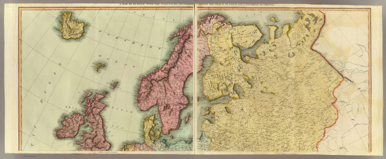
Author
Thomson, John
Full Title
A map of Europe with the political divisions after the Peace of Paris and Congress of Vienna. Drawn & engraved for Thomson's New general atlas, 1816.
List No
1007.035
Note
Two engraved maps. Hand colored. Sheets 1 and 2 (or the northern half) of "Europe after the Congress of Vienna" engraved by Neele. Relief shown by hachures.
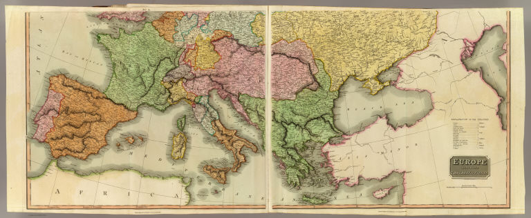
Author
Thomson, John
Full Title
Europe after the Congress of Vienna. Neele sculpt., 352 Strand, London. Drawn & engraved for Thomson's New general atlas, 1816.
List No
1007.036
Note
Two engraved maps. Hand colored. Sheets 3 and 4 (or the southern half). Sheets 1-2 have title in upper margins: A map of Europe with the political divisions after the Peace of Paris and Congress of Vienna. Relief shown by hachures.
Author
Thomson, John
Full Title
(Composite of) Europe after the Congress of Vienna. Neele sculpt., 352 Strand, London. Drawn & engraved for Thomson's New general atlas, 1816.
List No
1007.037
Note
Composite of four engraved maps. Hand colored. Sheets 1-2 have title in upper margins: A map of Europe with the political divisions after the Peace of Paris and Congress of Vienna. Relief shown by hachures.
Author
[Pawley, Neele, Samuel John, 1758-1824, Neele, George, Pinnock and Maunder]
Full Title
Europe. Neele sculpt. Published Jany. 1st. 1819, by Pinnock & Maunder Strand.
List No
14326.007
Note
Map of Europe and vicinity. Shows continental boundaries and political boundaries, cities, topography, major lakes and drainage, coastlines and islands. Relief shown with hachures. Includes latitudinal and longitudinal lines, as well as a compass rose and bar scale, given in British statute miles. Hand-colored engraving, including illustration of clouds behind title. Map is 27 x 22 cm, on sheet 34 x 26 cm.
1-9 of 9
|