|
Author
[Blackmore, Nathaniel, Moll, Herman, d. 1732]
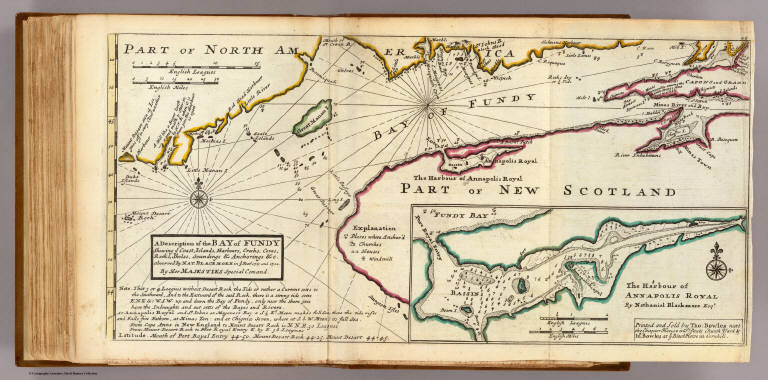
Full Title
A description of the Bay of Fundy shewing ye coast, islands, harbours, creeks, coves, rocks & sholes, soundings & anchorings &c. Observed by Nat. Blackmore in ye year 1711 and 1712. by Her Majesties Special Command. (Drawn by H. Moll, Geographer). (with) The harbour of Annapolis royal by Nathaniel Blackmore Esqr. Printed and sold by Tho: Bowles next ye Chapter House in St. Pauls Church Yard, & Ino: Bowles at ye Black Horse in Cornhill, (1736?)
List No
5580.048
Note
Hand col. engraved map with inset. Depths shown by soundings. Includes geographical note.
Author
Moll, Herman, d. 1732
Full Title
New England, New York, New Jersey and Pensilvania. By H. Moll, Geographer. (Printed and sold by Tho: Bowles next ye Chapter House in St. Pauls Church Yard, & Ino: Bowles at ye Black Horse in Cornhill, 1736?)
List No
5580.049
Note
Hand col. engraved map. Includes geographical note.
Author
[Herrman, Augustine, 1621-1686, Moll, Herman, d. 1732]
Full Title
Virginia and Maryland. By H. Moll, Geographer. (Printed and sold by Tho: Bowles next ye Chapter House in St. Pauls Church Yard, & Ino: Bowles at ye Black Horse in Cornhill, 1736?)
List No
5580.050
Note
Hand col. engraved map. A reduced copy of Augustine Herrman's map of 1670 (Swem, Phillips Virginia).
Author
Moll, Herman, d. 1732
Full Title
Carolina by H. Moll, Geographer. (Printed and sold by Tho: Bowles next ye Chapter House in St. Pauls Church Yard, & Ino: Bowles at ye Black Horse in Cornhill, 1736?)
List No
5580.051
Note
Hand col. engraved map. Relief shown pictorially.
Author
Moll, Herman, d. 1732
Full Title
A plan of Port Royal Harbour in Carolina with the proposed forts, depth of water &c. ... According to an original draught by H. Moll. (Printed and sold by Tho: Bowles next ye Chapter House in St. Pauls Church Yard, & Ino: Bowles at ye Black Horse in Cornhill, 1736?)
List No
5580.052
Note
Hand col. engraved map. Depths shown by soundings.
Author
Moll, Herman, d. 1732
Full Title
The island of Bermudos. Divided into its tribes with the castles, forts &c. by H. Moll Geographer. Part of Providence Island. (Printed and sold by Tho: Bowles next ye Chapter House in St. Pauls Church Yard, & Ino: Bowles at ye Black Horse in Cornhill, 1736?)
List No
5580.053
Note
Two hand col. engraved maps. Providence I. map shows depths by soundings. Scales: Bermodos (ca. 1:140,000); Providence (ca. 1:110,000).
Author
Moll, Herman, d. 1732
Full Title
Florida called by ye French Louisiana &c. By H. Moll Geographer. (Printed and sold by Tho: Bowles next ye Chapter House in St. Pauls Church Yard, & Ino: Bowles at ye Black Horse in Cornhill, 1736?)
List No
5580.054
Note
Hand col. engraved map. Relief shown pictorially. David Rumsey Collection copy annotated in pencil.
Author
Moll, Herman, d. 1732
Full Title
A map of the West-Indies &c., Mexico or New Spain. Also ye trade winds, and ye several tracts made by ye Galeons and Flota from place to place. By H. Moll Geographer. (Printed and sold by Tho: Bowles next ye Chapter House in St. Pauls Church Yard, & Ino: Bowles at ye Black Horse in Cornhill, 1736?)
List No
5580.055
Note
Hand col. engraved map. Relief shown pictorially. Includes geographical note.
Author
Moll, Herman, d. 1732
Full Title
The island of Jamaica divided into its principal parishes with the roads &c. By H. Moll Geographer. (Printed and sold by Tho: Bowles next ye Chapter House in St. Pauls Church Yard, & Ino: Bowles at ye Black Horse in Cornhill, 1736?)
List No
5580.056
Note
Hand col. engraved map. Relief shown pictorially. Shows churches and sugar, cotton, indigo and cacao works, etc. Includes geographical note.
Author
Moll, Herman, d. 1732
Full Title
The island of St. Christophers, alias St. Kitts. By H. Moll Geographer. (Printed and sold by Tho: Bowles next ye Chapter House in St. Pauls Church Yard, & Ino: Bowles at ye Black Horse in Cornhill, 1736?)
List No
5580.057
Note
Hand col. engraved map. Relief shown pictorially. Includes geographical note.
Author
Moll, Herman, d. 1732
Full Title
The island of Antego. By H. Moll Geographer. Sold by T. Bowles next ye Chapter House in St. Pauls Church yard, & I. Bowles at the Black Horse in Cornhill, (1736?)
List No
5580.058
Note
Hand col. engraved map. Depths shown by soundings. Shows churches, forts, plantations, windmills, cattle mills, submerged rocks, etc.
Author
Moll, Herman, d. 1732
Full Title
The island of Barbadoes. Divided into its parishes, with the roads, paths, &c. According to an actual and accurate survey. By H. Moll Geographer. Printed and sold by Tho: Bowles next ye Chapter House in St. Pauls Church yard, & I. Bowles at the Black Horse in Cornhill, (1736?)
List No
5580.059
Note
Hand col. engraved map. Relief shown pictorially. Shows churches, forts, plantations, windmills, submerged rocks, etc. Includes table of areas of parishes and geographical note. Oriented with north toward left.
Author
Moll, Herman, d. 1732
Full Title
The Scots settlement in America called New Caledonia. A.D. 1699. Lat. 8-30 North. According to an original draught. By H. Moll Geographer. (Printed and sold by Tho: Bowles next ye Chapter House in St. Pauls Church yard, & I. Bowles at the Black Horse in Cornhill, 1736?)
List No
5580.060
Note
Hand col. engraved map. Relief shown pictorially; depths by soundings. Includes geographical note.
Author
Moll, Herman, d. 1732
Full Title
A map of Terra Firma, Peru, Amazone-Land, Brasil &c., the north p. of La Plata. By H. Moll Geographer. (Printed and sold by Tho: Bowles next ye Chapter House in St. Pauls Church yard, & I. Bowles at the Black Horse in Cornhill, 1736?)
List No
5580.061
Note
Hand col. engraved map. Relief shown pictorially.
Author
Moll, Herman, d. 1732
Full Title
A map of Chili, Patagonia, La Plata and ye south part of Brasil. By H. Moll Geographer. (Printed and sold by Tho: Bowles next ye Chapter House in St. Pauls Church yard, & I. Bowles at the Black Horse in Cornhill, 1736?)
List No
5580.062
Note
Hand col. engraved map. Relief shown pictorially.
Author
Moll, Herman, d. 1732
Full Title
(Covers to) The World Described; or, A New and Correct Sett of Maps.
List No
9729.001
Note
Brown leather cover with stamped pattern. This is Moll's most impressive atlas, although it is largely just a collection of maps with a paste down title on the inside front cover. The maps are filled with Moll's observations, opinions, and knowledge and these annotations make the maps special and very personal, compared to other maps of the same period. The "beaver" map in this copy is state 6 and dates the overall atlas at 1732. Moll first issued the atlas ca. 1715-17 and it had a republishing history of over 30 years. Moll was born in Holland and came to London around 1680. He published a large group of geographic books, atlases, and maps. At the bottom of the paste down listing of the atlas contents, Moll states "These maps are the most correct, entertaining, and historical of any yet made..." Outline color. Relief in sketches.
Author
Moll, Herman, d. 1732
Full Title
(Title and Index Page to) The World Described; or, A New and Correct Sett of Maps.
List No
9729.002
Note
Pasted into inner front cover. This is Moll's most impressive atlas, although it is largely just a collection of maps with a paste down title on the inside front cover. The maps are filled with Moll's observations, opinions, and knowledge and these annotations make the maps special and very personal, compared to other maps of the same period. The "beaver" map in this copy is state 6 and dates the overall atlas at 1732. Moll first issued the atlas ca. 1715-17 and it had a republishing history of over 30 years. Moll was born in Holland and came to London around 1680. He published a large group of geographic books, atlases, and maps. At the bottom of the paste down listing of the atlas contents, Moll states "These maps are the most correct, entertaining, and historical of any yet made..." Outline color. Relief in sketches.
Author
Moll, Herman, d. 1732
Full Title
A New and Correct Map of the World, Laid Down According to the Newest Discoveries and from the most Exact Observations. By Herman Moll, Geographer.
List No
9729.003
Note
Foldout. Hemispheric projection.
Author
Moll, Herman, d. 1732
Full Title
A New & Correct Map of the Whole World.
List No
9729.004
Note
Mercator projection.
Author
Moll, Herman, d. 1732
Full Title
This map of Europe.
List No
9729.005
Author
Moll, Herman, d. 1732
Full Title
This Map of Asia.
List No
9729.006
Author
Moll, Herman, d. 1732
Full Title
A Map of the East-Indies. (insets) Bantam. Goa. Surat. Madras. Batavia.
List No
9729.007
Author
Moll, Herman, d. 1732
Full Title
This Map of Africa. (insets) Cape of Good Hope. Cape Coast Castle on ye Gold Coast of Guinea. James Fort on the Island of St. Helena. Fort of Good Hope.
List No
9729.008
Author
Moll, Herman, d. 1732
Full Title
This Map of North America. (insets) Ten American harbors. Scene of fishing and fish curing in Newfoundland.
List No
9729.009
Note
Known as the "Codfish" map because of the scenes of fishing and fish processing.
Author
Moll, Herman, d. 1732
Full Title
A New Map of the North Parts of America Claimed by France. (insets) Harbour of Annapolis Royal. Mouth of the Mississippi. The Indian Fort Sasquesahanok
List No
9729.011
Author
Moll, Herman, d. 1732
Full Title
Map of the West Indies. (insets) Five harbours.
List No
9729.012
Note
Date estimated.
Author
Moll, Herman, d. 1732
Full Title
This Map of South America. (inset) Scene of Potosi, Peru.
List No
9729.013
Note
Date estimated.
Author
Moll, Herman, d. 1732
Full Title
A New and Exact Map of the Coast Countries and Islands within the Limits of the South Sea Company. (insets) Ten harbours and coastal areas.
List No
9729.014
Note
Date estimated.
Author
Moll, Herman, d. 1732
Full Title
This Map of Moscovy, Poland, Little Tartary and ye Black Sea. (inset) North Part of Russia.
List No
9729.015
Note
Date estimated.
Author
Moll, Herman, d. 1732
Full Title
A New Map of Denmark and Sweden. (insets) Five scenes of the life of the Laplanders. North Part of Norway, Lapland, and Greenland.
List No
9729.016
Note
Date estimated.
Author
Moll, Herman, d. 1732
Full Title
A New Map of Baltick.
List No
9729.017
Note
Date estimated.
Author
Moll, Herman, d. 1732
Full Title
A New Map of Great Britain.
List No
9729.018
Note
Date estimated.
Author
Moll, Herman, d. 1732
Full Title
The South Part of Great Britain, Called England and Wales.
List No
9729.019
Note
Place names index included.
Author
Moll, Herman, d. 1732
Full Title
The North Part of Great Britain Called Scotland. (insets) Shetland and Orkney Islands. Views of Edinburg, Glasgow, St. Andrews, Sterling, Montrose, Aberdeen, Edinbug Castle, Sterling Castle, Dunotyr Castle at Merns, The Bass, and Cannery Town in Ross.
List No
9729.020
Author
Moll, Herman, d. 1732
Full Title
A New Map of Ireland. (insets) Isle of St. Partick's Purgatory, Gyants Cawsway (Giants Causeway), Waterford, Gallway, Kinsale, Limrick, Dublin, Cork.
List No
9729.021
Author
Moll, Herman, d. 1732
Full Title
A New Map of Germany, Hungary, Transilvania and the Suisse.
List No
9729.022
Author
Moll, Herman, d. 1732
Full Title
A New and Exact Map of the Electorate of Brunswick-Lundenbrg and ye rest of the Kings Dominions in Germany.
List No
9729.023
Note
Date estimated.
Author
Moll, Herman, d. 1732
Full Title
The Seat of War in the Rhine being a New Map of the Course of that Rive(r) from Basil to Bonn.
List No
9729.024
Note
Date estimated.
Author
Moll, Herman, d. 1732
Full Title
A New and Exact Map of the United Provinces of the Netherlands. (insets) Views of Amsterdam, Middelburg, Utrecht, Gronningen, T'Loo. Maps of Arx Britannica, Rotterdam, North Sea.
List No
9729.025
Note
Date estimated.
Author
Moll, Herman, d. 1732
Full Title
Les Provinces des Pays-Bas Catholiques ou ... Flanders or Austrian Netherlands. (inset) A hypothetical fortification.
List No
9729.026
Note
Date estimated.
Author
Moll, Herman, d. 1732
Full Title
A New and Exact Map of France.
List No
9729.027
Note
Place names index included. Date estimated.
Author
Moll, Herman, d. 1732
Full Title
A New and Exact Map of Spain & Portugal.
List No
9729.028
Author
Moll, Herman, d. 1732
Full Title
A New Map of Italy. (insets) Views of Mt. Etna, Mt, Vesuvius, and Mt. Aeolius.
List No
9729.029
Note
Date estimated.
Author
Moll, Herman, d. 1732
Full Title
A New Map of the Upper Part of Italy. (insets) Views of basic layout of fortifications for ten Italian cities.
List No
9729.030
Note
Date estimated.
Author
Moll, Herman, d. 1732
Full Title
The Turkish Empire in Europe, Asia and Africa. (insets) Views of Jerusalem, Chuch of the Holy Sepulcre, and Smirna.
List No
9729.031
Note
Date estimated.
Author
Moll, Herman, d. 1732
Full Title
An Historic Map of the Roman Empire....
List No
9729.032
Note
Date estimated.
Author
Moll, Herman, d. 1732
Full Title
(Covers to) A set of fifty new and correct maps of the counties of England and Wales, &c. with the great roads and principal cross-roads, &c. Shewing the computed miles from town to town. : a work long wanted, and very useful for all gentlemen that travel to any part of England. All, except two, composed and done by Herman Moll, geographer... And, to render this work more acceptable to the curious, the margins of each map are adorned with great variety of very remarkable antiquities. London : Sold by H. Moll over - against Devereux-Court in Stand; Tho. Bowles, print and map-seller, near the Chapter-House in St Paul's Church-Yard; and J. Bowles, print and map-seller over-against Stock-Market. 1724.
List No
9883.001
Note
Uncolored maps, some folded. Bound in brown leather cover with "Moll map Eng. stamped on the spine in gilt. Title page includes contents. Maps showing roads, cities and towns, mines, cemetery, landmarks, light house, etc. Some landmarks shown pictorially. Relief shown by hachures.
Author
Moll, Herman, d. 1732
Full Title
(Title Page/Contents to) A set of fifty new and correct maps of the counties of England and Wales, &c. with the great roads and principal cross-roads, &c. Shewing the computed miles from town to town. : a work long wanted, and very useful for all gentlemen that travel to any part of England. All, except two, composed and done by Herman Moll, geographer... And, to render this work more acceptable to the curious, the margins of each map are adorned with great variety of very remarkable antiquities. London : Sold by H. Moll over - against Devereux-Court in Stand; Tho. Bowles, print and map-seller, near the Chapter-House in St Paul's Church-Yard; and J. Bowles, print and map-seller over-against Stock-Market. 1724.
List No
9883.002
Note
Uncolored maps, some folded. Bound in brown leather cover with "Moll map Eng. stamped on the spine in gilt. Title page includes contents. Maps showing roads, cities and towns, mines, cemetery, landmarks, light house, etc. Some landmarks shown pictorially. Relief shown by hachures.
Author
[Moll, Herman, d. 1732, Stukeley, William (1687-1765)]
Full Title
In gratiam Itinerantium Curiosorum Antonini Aug. Itinerarium per Britanniam, tentavit W. Stukeley 1723. (to accompany) A set of fifty new and correct maps of the counties of England and Wales, &c. 1724.
List No
9883.003
Note
Map of Great Britain, folded. Showing roads, rivers, cities and town. Place names given in Latin and English.
Author
Moll, Herman, d. 1732
Full Title
England & Wales with the Islands of Garnsey, Iersey & c. By H.M. (to accompany) A set of fifty new and correct maps of the counties of England and Wales, &c. 1724.
List No
9883.004
Note
Map of England and Wales, folded. Showing county boundaries, roads, rivers, cities and town. Compass rose oriented with the north to upper left.
|