|
REFINE
Browse All : Images by Mexico Republica from 1825
1-4 of 4
Author
[Mexico Republica, (Espinosa y Tello, J.)]
Full Title
Carta General Para Las Navegaciones a la India Oriental Por El Mar Del Sur Y el grande Oceano que Separa el Continente Americano del Asiatico, Construida Segun las derrotas, Observaciones y trabajos de los mas Celebres Naveganles Espanoles Y Publicada por Orden del Exmo Sr. D. Guadalupe Victoria Primer Presidente de la Republica Mexico Ano de 1825. Los numberos de la Sonda son braxas de 6 pics de Burgos. (inset map on sheet 2) Plano Geometrico del Embocadero De S. Bernadino ano 1792. (inset map) Parte De La Isla De Samar.
List No
3775.001
Note
One map on 2 sheets. West sheet. First Mexican edition of Espinosa y Tello's chart of 1814, London. In two sheets, one covering the western coast of America, the other the eastern coast of Asia. The original London edition was in six sheets, and the two sheets of the Mexican edition have borders that suggest another four sheets, although it is not known if they were printed. Map is without color. "Longitude oeste de Cadiz". Emblem with eagle perched on boat surrounded by 2 sails and 2 anchors in lower left corner of the east sheet. Relief shown by hachures. Depth by soundings. Shows routes of Spanish voyages and date of exploration in the Pacific, including the Northwest Coast of North America. Covers northwest coast of America, Kamchatka, Japan, the Philippines, Hawaii & most of Micronesia.
Author
[Mexico Republica, (Espinosa y Tello, J.)]
Full Title
Carta General Para Las Navegaciones a la India Oriental Por El Mar Del Sur Y el grande Oceano que Separa el Continente Americano del Asiatico, Construida Segun las derrotas, Observaciones y trabajos de los mas Celebres Naveganles Espanoles Y Publicada por Orden del Exmo Sr. D. Guadalupe Victoria Primer Presidente de la Republica Mexico Ano de 1825. Los numberos de la Sonda son braxas de 6 pics de Burgos. (inset map on sheet 2) Plano Geometrico del Embocadero De S. Bernadino ano 1792. (inset map) Parte De La Isla De Samar.
List No
3775.002
Note
One map on 2 sheets. East sheet. First Mexican edition of Espinosa y Tello's chart of 1814, London. In two sheets, one covering the western coast of America, the other the eastern coast of Asia. The original London edition was in six sheets, and the two sheets of the Mexican edition have borders that suggest another four sheets, although it is not known if they were printed. Map is without color. "Longitude oeste de Cadiz". Emblem with eagle perched on boat surrounded by 2 sails and 2 anchors in lower left corner of the east sheet. Relief shown by hachures. Depth by soundings. Shows routes of Spanish voyages and date of exploration in the Pacific, including the Northwest Coast of North America. Covers northwest coast of America, Kamchatka, Japan, the Philippines, Hawaii & most of Micronesia.
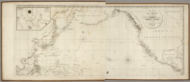
Author
[Mexico Republica, (Espinosa y Tello, J.)]
Full Title
(Composite of) Carta General Para Las Navegaciones a la India Oriental Por El Mar Del Sur Y el grande Oceano que Separa el Continente Americano del Asiatico, Construida Segun las derrotas, Observaciones y trabajos de los mas Celebres Naveganles Espanoles Y Publicada por Orden del Exmo Sr. D. Guadalupe Victoria Primer Presidente de la Republica Mexico Ano de 1825. Los numberos de la Sonda son braxas de 6 pics de Burgos. (inset map on sheet 2) Plano Geometrico del Embocadero De S. Bernadino ano 1792. (inset map) Parte De La Isla De Samar.
List No
3775.003
Note
One map on 2 sheets, here with the two sheets joined digitally.
Author
[Spain, Dirección de Hydrographia, Bauza, Felipe, Mexico Republica]
Full Title
Carta Esferica de las Costas Y Golfo De Californias Llamado Mar De Cortes que Comprende desde et Cabo Corrientes hasta el Puerto de S. Diego Constuida Por les oficiales de la Marina Espanola, y publicado por orn del Exmo Sr. D. Guadalupe Victoria Primer Presidente de la Republica Mexico Ano de 1825. (with 3 inset chart maps).
List No
4233.000
Note
This is a reissue in Mexico City of the 1825 Madrid issue by the Spanish Direccion de Hydrographia. The French also issued a copy of the Madrid edition in 1826 (see our copy). Apparently, the Mexican Republic produced a large number of charts in 1825, copied from Spanish charts (see also the 1825 "Carta General...el grande Oceano que separa el Continente Americano del Asiatico..."). Inset charts are titled: Plano del Puerto Del Guaimas, Plano De La Bahia De La Paz, and Plano del Puerto De Pichilingue. Printed without color. Relief shown by hachures and depth by soundings
1-4 of 4
|