|
Author
[Lloyd, H.H., Stebbins, Henry S.]
Full Title
(Covers to) New Map Of Ohio. Published by Henry S. Stebbins, Toledo, Ohio. Ingham & Bragg, Cleveland, Ohio. Entered ... in the year 1870 by H.H. Lloyed & Co. ... New York.
List No
0953.001
Note
Copyright by H.H. Lloyd, published by Stebbins. Full color by county, folded into brown leather covers 14x9 with "Stebbins New Township Map Of Ohio." stamped in gilt. Prime meridian is Washington D.C.
Author
[Lloyd, H.H., Stebbins, Henry S.]
Full Title
New Map Of Ohio. Published by Henry S. Stebbins, Toledo, Ohio. Ingham & Bragg, Cleveland, Ohio. Entered ... in the year 1870 by H.H. Lloyed & Co. ... New York.
List No
0953.002
Note
Copyright by H.H. Lloyd, published by Stebbins. Full color by county, folded into brown leather covers 14x9 with "Stebbins New Township Map Of Ohio." stamped in gilt. Prime meridian is Washington D.C.
Author
[Lloyd, H.H., Stebbins, Henry S.]
Full Title
(Covers to) New Map Of Ohio. Published By Henry S. Stebbins, Toledo Ohio. 1875. Entered ... 1866, by H.H. Lloyd & Co ... New York.
List No
0954.001
Note
Copyright by H.H. Lloyd, published by Stebbins. Includes population statistics for Ohio and the U.S. Changes from the 1870 edition. Map is full color by county, folded into green stamped cloth covers 15x11 with "Stebbins New Township Map of Ohio" in gilt.
Author
[Lloyd, H.H., Stebbins, Henry S.]
Full Title
(Covers to) New Map Of Ohio. Published By Henry S. Stebbins, Toledo Ohio. 1875. Entered ... 1866, by H.H. Lloyd & Co ... New York.
List No
0954.002
Note
Copyright by H.H. Lloyd, published by Stebbins. Includes population statistics for Ohio and the U.S. Changes from the 1870 edition. Map is full color by county, folded into green stamped cloth covers 15x11 with "Stebbins New Township Map of Ohio" in gilt.
Author
[Gray, Ormando Willis, Lloyd, H.H., Walling, H. F.]
Full Title
(Covers to) New topographical atlas of the State of Ohio. With descriptions historical, scientific, and statistical, together with maps of the Untied States and territories. By H.F. Walling, and O.W. Gray, civil and topographical engineers. Published by Stedman, Brown & Lyon, Cincinnati. 1872. Entered ... 1872, by H.F. Walling, and O.W. Gray, and H.H. Lloyd & Co. ... Washington.
List No
2710A
Note
H.H. Lloyd's Atlas of U.S. in rear. See the earlier version of this atlas published in 1868 (our #4726). Bound in half leather dark greenish brown cloth covered boards with "Topographical atlas of Ohio and the United States" gold stamped on the front cover and blind stamped on the back.
Author
[Gray, Ormando Willis, Lloyd, H.H., Walling, H. F.]
Full Title
(Title Page to) New topographical atlas of the State of Ohio. With descriptions historical, scientific, and statistical, together with maps of the Untied States and territories. By H.F. Walling, and O.W. Gray, civil and topographical engineers. Published by Stedman, Brown & Lyon, Cincinnati. 1872. Entered ... 1872, by H.F. Walling, and O.W. Gray, and H.H. Lloyd & Co. ... Washington.
List No
2710B
Note
H.H. Lloyd's Atlas of U.S. in rear. See the earlier version of this atlas published in 1868 (our #4726). Bound in half leather dark greenish brown cloth covered boards with "Topographical atlas of Ohio and the United States" gold stamped on the front cover and blind stamped on the back.
Author
[Gray, Ormando Willis, Lloyd, H.H., Walling, H. F.]
Full Title
(Title Page Verso to) New topographical atlas of the State of Ohio. With descriptions historical, scientific, and statistical, together with maps of the Untied States and territories. By H.F. Walling, and O.W. Gray, civil and topographical engineers. Published by Stedman, Brown & Lyon, Cincinnati. 1872. Entered ... 1872, by H.F. Walling, and O.W. Gray, and H.H. Lloyd & Co. ... Washington.
List No
2710C
Note
H.H. Lloyd's Atlas of U.S. in rear. See the earlier version of this atlas published in 1868 (our #4726). Bound in half leather dark greenish brown cloth covered boards with "Topographical atlas of Ohio and the United States" gold stamped on the front cover and blind stamped on the back.
Author
[Gray, Ormando Willis, Lloyd, H.H., Walling, H. F.]
Full Title
(Contents to) New topographical atlas of the State of Ohio. With descriptions historical, scientific, and statistical, together with maps of the Untied States and territories. By H.F. Walling, and O.W. Gray, civil and topographical engineers. Published by Stedman, Brown & Lyon, Cincinnati. 1872. Entered ... 1872, by H.F. Walling, and O.W. Gray, and H.H. Lloyd & Co. ... Washington.
List No
2710D
Note
H.H. Lloyd's Atlas of U.S. in rear. See the earlier version of this atlas published in 1868 (our #4726). Bound in half leather dark greenish brown cloth covered boards with "Topographical atlas of Ohio and the United States" gold stamped on the front cover and blind stamped on the back.
Author
[Slater, J., Whittlesey, Chas.]
Full Title
Historical map of the State of Ohio. Showing the location of ancient earth works and the country occupied by the principal Indian tribes between 1750 and 1780 with their principal trails and war-paths by Col. Chas. Whittlesey, President of the Western Reserve and Northern Ohio Historical Society, Cleveland, Ohio, 1872. (with view) Ancient mound 2 miles east of Miamisburg, Montgomery Co., Ohio ... Photographed ... by J. Slater, 1872. (Published by Stedman, Brown & Lyon, Cincinnati. 1872. Entered ... 1872, by H.F. Walling, and O.W. Gray, and H.H. Lloyd & Co. ... Washington)
List No
2710.001
Note
Col. lithographed map.
Author
Newberry, John S.
Full Title
Geological map of Ohio by J.S. Newberry, Chief Geologist, 1872. (Published by Stedman, Brown & Lyon, Cincinnati. 1872. Entered ... 1872, by H.F. Walling, and O.W. Gray, and H.H. Lloyd & Co. ... Washington)
List No
2710.002
Note
Col. lithographed map. Includes "Section through northern Ohio," "Section from Cincinnati to Marietta," and explanation of colors.
Author
Klippart, J. H.
Full Title
Agricultural map of Ohio. Showing the distribution of soils, the localities of the principal productions, and the names and limits of the valleys and other natural divisions. By J.H. Klippart, Secretary of the Ohio State Board of Agriculture. 1872. (Published by Stedman, Brown & Lyon, Cincinnati. 1872. Entered ... 1872, by H.F. Walling, and O.W. Gray, and H.H. Lloyd & Co. ... Washington)
List No
2710.003
Note
Col. lithographed map.
Author
Blodget, Lorin
Full Title
Climatological map of the State of Ohio. By Lorin Blodget, 1872. (Published by Stedman, Brown & Lyon, Cincinnati. 1872. Entered ... 1872, by H.F. Walling, and O.W. Gray, and H.H. Lloyd & Co. ... Washington)
List No
2710.004
Note
Col. lithographed map. Has isolines showing mean temperatures for summer, winter and year, and shading showing annual rainfall in inches.
Author
Bowen, B. F.
Full Title
City of Columbus, Franklin Co., Ohio. Drawn by B.F. Bowen, City Eng., Columbus, O., 1872. (Published by Stedman, Brown & Lyon, Cincinnati. 1872. Entered ... 1872, by H.F. Walling, and O.W. Gray, and H.H. Lloyd & Co. ... Washington)
List No
2710.005
Note
Hand col. lithographed map. Shows wards, etc.
Author
Gray, Frank Arnold
Full Title
New rail road map of the State of Ohio, compiled and drawn by Frank Arnold Gray, 1872. (Published by Stedman, Brown & Lyon, Cincinnati. 1872. Entered ... 1872, by H.F. Walling, and O.W. Gray, and H.H. Lloyd & Co. ... Washington)
List No
2710.006
Note
Hand col. lithographed map. Counties in full color.
Author
[Gray, Ormando Willis, Lloyd, H.H., Walling, H. F.]
Full Title
Cleveland, Cayahoga Co. From data furnished by City Engineer. 1872. (Published by Stedman, Brown & Lyon, Cincinnati. 1872. Entered ... 1872, by H.F. Walling, and O.W. Gray, and H.H. Lloyd & Co. ... Washington)
List No
2710.007
Note
Hand col. lithographed map. Shows wards, etc.
Author
Marston, John B.
Full Title
Toledo, Lucas Co. by J.B. Marston, C.E., Toledo O. (Published by Stedman, Brown & Lyon, Cincinnati. 1872. Entered ... 1872, by H.F. Walling, and O.W. Gray, and H.H. Lloyd & Co. ... Washington)
List No
2710.008
Note
Hand col. lithographed map. Shows wards, owners of large parcels, radial distances from downtown., etc.
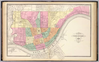
Author
[Gray, Ormando Willis, Lloyd, H.H., Walling, H. F.]
Full Title
City of Cincinnati, Ohio. 1872. (Published by Stedman, Brown & Lyon, Cincinnati. 1872. Entered ... 1872, by H.F. Walling, and O.W. Gray, and H.H. Lloyd & Co. ... Washington)
List No
2710.009
Note
Hand col. lithographed map. Shows wards, etc.
Author
[Gray, Ormando Willis, Lloyd, H.H., Walling, H. F.]
Full Title
Dayton. (Published by Stedman, Brown & Lyon, Cincinnati. 1872. Entered ... 1872, by H.F. Walling, and O.W. Gray, and H.H. Lloyd & Co. ... Washington)
List No
2710.010
Note
Hand col. lithographed map. Shows wards, etc.
Author
Moler, J. Douglass
Full Title
Springfield, Clarke Co. by J. Douglass Moler, City Engr. (Published by Stedman, Brown & Lyon, Cincinnati. 1872. Entered ... 1872, by H.F. Walling, and O.W. Gray, and H.H. Lloyd & Co. ... Washington)
List No
2710.011
Note
Hand col. lithographed map. Shows wards, etc.
Author
[Gray, Ormando Willis, Lloyd, H.H., Walling, H. F.]
Full Title
Topographical atlas of Ohio. Cuyahoga, Erie, Huron, Lorain, Medina, Ottawa, Sandusky, Seneca and Summit counties. (Published by Stedman, Brown & Lyon, Cincinnati. 1872. Entered ... 1872, by H.F. Walling, and O.W. Gray, and H.H. Lloyd & Co. ... Washington)
List No
2710.012
Note
Hand col. lithographed map. Shows townships and sections, etc.
Author
[Gray, Ormando Willis, Lloyd, H.H., Walling, H. F.]
Full Title
Topographical atlas of Ohio. Ashtabula, Geauga, Lake, Mahoning, Portage and Trumbull counties. (Published by Stedman, Brown & Lyon, Cincinnati. 1872. Entered ... 1872, by H.F. Walling, and O.W. Gray, and H.H. Lloyd & Co. ... Washington)
List No
2710.013
Note
Hand col. lithographed map. Shows townships and sections, etc.
Author
[Gray, Ormando Willis, Lloyd, H.H., Walling, H. F.]
Full Title
Topographical atlas of Ohio. Carroll, Columbiana, Harrison, Jefferson, Stark and Tuscarawas counties. (Published by Stedman, Brown & Lyon, Cincinnati. 1872. Entered ... 1872, by H.F. Walling, and O.W. Gray, and H.H. Lloyd & Co. ... Washington)
List No
2710.014
Note
Hand col. lithographed map. Shows townships and sections, etc.
Author
[Gray, Ormando Willis, Lloyd, H.H., Walling, H. F.]
Full Title
Topographical atlas of Ohio. Athens, Belmont, Fairfield, Guernsey, Hocking, Licking, Monroe, Morgan, Muskingum, Noble, Perry and Washington counties. (Published by Stedman, Brown & Lyon, Cincinnati. 1872. Entered ... 1872, by H.F. Walling, and O.W. Gray, and H.H. Lloyd & Co. ... Washington)
List No
2710.015
Note
Hand col. lithographed map. Shows townships and sections, etc.
Author
[Gray, Ormando Willis, Lloyd, H.H., Walling, H. F.]
Full Title
Topographical atlas of Ohio. Gallia, Jackson, Lawrence, Meigs, and Vinton counties. (Published by Stedman, Brown & Lyon, Cincinnati. 1872. Entered ... 1872, by H.F. Walling, and O.W. Gray, and H.H. Lloyd & Co. ... Washington)
List No
2710.016
Note
Hand col. lithographed map. Shows townships and sections, etc.
Author
[Gray, Ormando Willis, Lloyd, H.H., Walling, H. F.]
Full Title
Topographical atlas of Ohio. Adams, Brown, Highland, Pike, and Scioto counties. (Published by Stedman, Brown & Lyon, Cincinnati. 1872. Entered ... 1872, by H.F. Walling, and O.W. Gray, and H.H. Lloyd & Co. ... Washington)
List No
2710.017
Note
Hand col. lithographed map. Shows townships and sections, etc.
Author
[Gray, Ormando Willis, Lloyd, H.H., Walling, H. F.]
Full Title
Topographical atlas of Ohio. Auglaize, Champaign, Clarke, Darke, Delaware, Franklin, Hardin, Logan, Madison, Marion, Mercer, Miami, Morrow, Shelby and Union counties. (Published by Stedman, Brown & Lyon, Cincinnati. 1872. Entered ... 1872, by H.F. Walling, and O.W. Gray, and H.H. Lloyd & Co. ... Washington)
List No
2710.018
Note
Hand col. lithographed map. Shows townships and sections, etc.
Author
[Gray, Ormando Willis, Lloyd, H.H., Walling, H. F.]
Full Title
Topographical atlas of Ohio. Clinton, Fayette, Greene, Pickaway, and Ross counties. (Published by Stedman, Brown & Lyon, Cincinnati. 1872. Entered ... 1872, by H.F. Walling, and O.W. Gray, and H.H. Lloyd & Co. ... Washington)
List No
2710.019
Note
Hand col. lithographed map. Shows townships and sections, etc.
Author
[Gray, Ormando Willis, Lloyd, H.H., Walling, H. F.]
Full Title
Topographical atlas of Ohio. Butler, Clermont, Hamilton, Montgomery, Preble and Warren counties. (Published by Stedman, Brown & Lyon, Cincinnati. 1872. Entered ... 1872, by H.F. Walling, and O.W. Gray, and H.H. Lloyd & Co. ... Washington)
List No
2710.020
Note
Hand col. lithographed map. Shows townships and sections, etc.
Author
[Gray, Ormando Willis, Lloyd, H.H., Walling, H. F.]
Full Title
Topographical atlas of Ohio. Allen, Crawford, Defiance, Fulton, Hancock, Henry, Lucas, Ottawa, Paulding, Putnam, Sandusky, Van Wert, Williams, Wood and Wyandot counties. (Published by Stedman, Brown & Lyon, Cincinnati. 1872. Entered ... 1872, by H.F. Walling, and O.W. Gray, and H.H. Lloyd & Co. ... Washington)
List No
2710.021
Note
Hand col. lithographed map. Shows townships and sections, etc.
Author
[Gray, Ormando Willis, Lloyd, H.H., Walling, H. F.]
Full Title
Topographical atlas of Ohio. Ashland, Coshocton, Holmes, Knox, Richland, and Wayne counties. (Published by Stedman, Brown & Lyon, Cincinnati. 1872. Entered ... 1872, by H.F. Walling, and O.W. Gray, and H.H. Lloyd & Co. ... Washington)
List No
2710.022
Note
Hand col. lithographed map. Shows townships and sections, etc.
Author
[Walling, Henry Francis, 1825-1888, Lloyd, H.H.]
Full Title
Climatological map of Ohio : showing the mean annual temperature and fall of rain, by Lorin Blodget. Published for Henry S. Stebbins By H.H. Lloyd & Co. New York. (to accompany) Atlas Of The State Of Ohio 1868.
List No
4726.006
Note
Hand colored map. Mean of seasonal temperature shown by isolines. Annual rainfall in inches shown by shading.
Author
[Walling, Henry Francis, 1825-1888, Lloyd, H.H.]
Full Title
Geological map of Ohio. By J. S. Newberry, L. L. D.Based upon that of Col. Charles Whittelsey. Published for Henry S. Stebbins By H.H. Lloyd & Co. New York. (to accompany) Atlas Of The State Of Ohio 1868.
List No
4726.008
Note
Hand colored map. Shows geologic formations, types of rock, towns, rivers, canals and railroads. Includes "Section through northern Ohio," "Section from Cincinnati to Marietta," and explanation of colors.
Author
[Walling, Henry Francis, 1825-1888, Lloyd, H.H.]
Full Title
Atlas of Ohio : Connecticut "Western Reserve" : including counties of Ashtabula, Trumbull, Mahoning, Lake, Geauga, Portage, Cuyahoga, Summit, Medina, Lorain, Erie and Huron. Published for Henry S. Stebbins By H.H. Lloyd & Co. New York. (to accompany) Atlas Of The State Of Ohio. 1868.
List No
4726.014
Note
Hand colored map. Shows administrative divisions, cities, towns, roads, railroads. Depth shown by isolines and soundings.
Author
[Walling, Henry Francis, 1825-1888, Lloyd, H.H.]
Full Title
Atlas of Ohio : Counties of Lucas, Ottawa, Wood, Sandusky, Hancock and Seneca. Published for Henry S. Stebbins By H.H. Lloyd & Co. New York. (to accompany) Atlas Of The State Of Ohio. 1868.
List No
4726.015
Note
Hand colored county map. Shows administrative divisions, cities, towns, roads, rivers, canals, railroads. Depth shown by isolines and soundings.
Author
[Walling, Henry Francis, 1825-1888, Lloyd, H.H.]
Full Title
Atlas of Ohio : Counties of Williams, Fulton, Defiance, Henry, Paulding and Putnam. Published for Henry S. Stebbins By H.H. Lloyd & Co. New York. (to accompany) Atlas Of The State Of Ohio. 1868.
List No
4726.016
Note
Hand colored county map. Shows administrative divisions, cities, towns, rivers, canals, lakes, roads and railroads.
Author
[Walling, Henry Francis, 1825-1888, Lloyd, H.H.]
Full Title
Atlas of Ohio : Counties of Hardin, Logan, Auglaize, Shelby, Allen, Van Wert and Mercer.Published for Henry S. Stebbins By H.H. Lloyd & Co. New York. (to accompany) Atlas Of The State Of Ohio. 1868.
List No
4726.017
Note
Hand colored county map. Shows administrative divisions, cities, towns, rivers, canals, lakes, roads and railroads.
Author
[Walling, Henry Francis, 1825-1888, Lloyd, H.H.]
Full Title
Atlas of Ohio : Counties of Wyandot, Crawford, Richland, Ashland, Marion, Morrow and Knox.Published for Henry S. Stebbins By H.H. Lloyd & Co. New York. (to accompany) Atlas Of The State Of Ohio. 1868.
List No
4726.018
Note
Hand colored county map. Shows administrative divisions, cities, towns, rivers, canals, lakes, roads and railroads.
Author
[Walling, Henry Francis, 1825-1888, Lloyd, H.H.]
Full Title
Atlas of Ohio : Counties of Wayne, Stark, Tuscarawas, Coshocton, and Holmes. Published for Henry S. Stebbins By H.H. Lloyd & Co. New York. (to accompany) Atlas Of The State Of Ohio. 1868.
List No
4726.019
Note
Hand colored county map. Shows administrative divisions, cities, towns, rivers, canals, lakes, roads and railroads.
Author
[Walling, Henry Francis, 1825-1888, Lloyd, H.H.]
Full Title
Atlas of Ohio : Counties of Columbiana, Jefferson, Carroll, and Harrison. Published for Henry S. Stebbins By H.H. Lloyd & Co. New York. (to accompany) Atlas Of The State Of Ohio. 1868.
List No
4726.020
Note
Hand colored county map. Shows administrative divisions, cities, towns, rivers, canals, lakes, roads and railroads.
Author
[Walling, Henry Francis, 1825-1888, Lloyd, H.H.]
Full Title
Atlas of Ohio : Counties of Guernsey, Belmont, Noble, and Monroe. Published for Henry S. Stebbins By H.H. Lloyd & Co. New York. (to accompany) Atlas Of The State Of Ohio. 1868.
List No
4726.021
Note
Hand colored map. Shows administrative divisions, cities, towns, rivers, canals, lakes, roads and railroads.
Author
[Walling, Henry Francis, 1825-1888, Lloyd, H.H.]
Full Title
Atlas of Ohio : Counties of Licking, Muskingum, Fairfield, Perry, and Morgan. Published for Henry S. Stebbins By H.H. Lloyd & Co. New York. (to accompany) Atlas Of The State Of Ohio. 1868.
List No
4726.022
Note
Hand colored county map. Shows administrative divisions, cities, towns, rivers, canals, lakes, roads and railroads.
Author
[Walling, Henry Francis, 1825-1888, Lloyd, H.H.]
Full Title
Atlas of Ohio : Counties of Union, Delaware, Franklin and Madison. Published for Henry S. Stebbins By H.H. Lloyd & Co. New York. (to accompany) Atlas Of The State Of Ohio. 1868.
List No
4726.023
Note
Hand colored county map. Shows administrative divisions, cities, towns, rivers, canals, lakes, roads and railroads.
Author
[Walling, Henry Francis, 1825-1888, Lloyd, H.H.]
Full Title
Atlas of Ohio : Counties of Champaign, Darke, Greene, Miami, Montgomery, Clarke and Preble. Published for Henry S. Stebbins By H.H. Lloyd & Co. New York. (to accompany) Atlas Of The State Of Ohio. 1868.
List No
4726.024
Note
Hand colored county map. Shows administrative divisions, cities, towns, rivers, canals, lakes, roads and railroads.
Author
[Walling, Henry Francis, 1825-1888, Lloyd, H.H.]
Full Title
Atlas of Ohio : Counties of Butler, Warren, Hamilton and Clermont. Published for Henry S. Stebbins By H.H. Lloyd & Co. New York. (to accompany) Atlas Of The State Of Ohio. 1868.
List No
4726.025
Note
Hand colored map. Shows administrative divisions, cities, towns, rivers, canals, lakes, roads and railroads.
Author
[Walling, Henry Francis, 1825-1888, Lloyd, H.H.]
Full Title
Atlas of Ohio : Counties of Fayette, Clinton, Brown, Highland and Adams. Published for Henry S. Stebbins By H.H. Lloyd & Co. New York. (to accompany) Atlas Of The State Of Ohio. 1868.
List No
4726.026
Note
Hand colored map. Shows administrative divisions, cities, towns, rivers, canals, lakes, roads and railroads. Relief shown by hachures.
Author
[Walling, Henry Francis, 1825-1888, Lloyd, H.H.]
Full Title
Atlas of Ohio : Counties of Pickaway, Hocking, Ross and Vinton. Published for Henry S. Stebbins By H.H. Lloyd & Co. New York. (to accompany) Atlas Of The State Of Ohio. 1868.
List No
4726.027
Note
Hand colored county map. Shows administrative divisions, cities, towns, rivers, canals, lakes, roads and railroads. Relief shown by hachures.
Author
[Walling, Henry Francis, 1825-1888, Lloyd, H.H.]
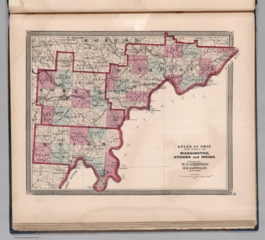
Full Title
Atlas of Ohio : Counties of Washington, Athens and Meigs. Published for Henry S. Stebbins By H.H. Lloyd & Co. New York. (to accompany) Atlas Of The State Of Ohio. 1868.
List No
4726.028
Note
Hand colored county map. Shows administrative divisions, cities, towns, rivers, canals, lakes, roads and railroads. Relief shown by hachures.
Author
[Walling, Henry Francis, 1825-1888, Lloyd, H.H.]
Full Title
Atlas of Ohio : Counties of Jackson, Gallia, Lawrence, Scioto and Pike. Published for Henry S. Stebbins By H.H. Lloyd & Co. New York. (to accompany) Atlas Of The State Of Ohio. 1868.
List No
4726.029
Note
Hand colored county map. Shows administrative divisions, cities, towns, rivers, canals, lakes, roads and railroads. Relief shown by hachures.
Author
[Walling, Henry Francis, 1825-1888, Lloyd, H.H.]
Full Title
Cincinnati. By R.C. Phillips, C.E. Published for Henry S. Stebbins By H.H. Lloyd & Co. New York. (to accompany) Atlas Of The State Of Ohio. 1868.
List No
4726.030
Note
Hand colored map. Shows wards, rivers, canals, bridges, streets and railroads.
Author
[Walling, Henry Francis, 1825-1888, Lloyd, H.H.]
Full Title
Atlas of Ohio : Cleveland : Cuyahoga Co. Published for Henry S. Stebbins By H.H. Lloyd & Co. New York. (to accompany) Atlas Of The State Of Ohio. 1868.
List No
4726.031
Note
Hand colored map. Shows wards, rivers, canals, bridges, streets and railroads. Depth shown by isolines.
|