|
REFINE
Browse All : Images by Kitchin, Thomas of Germany from 1794
1-8 of 8
Author
Robert Laurie & James Whittle
Full Title
A new map of Germany, divided into its circles, which are those of 1. Austria, 2. Lower Rhine or of the Four Electors, 3. Upper Saxony, 4. Bavaria, 5. Franconia, 6. Swabia, 7. Upper Rhine, 8. Westphalia, 9. Lower Saxony. London, Published by Laurie & Whittle, No. 53, Fleet Street, as the act directs May 12th 1794. (T. Kitchin sculpt.)
List No
2310.037
Note
Hand colored engraved map. Relief shown pictorially.
Author
[Delarochette, Louis Stanislas d'Arcy, Robert Laurie & James Whittle]
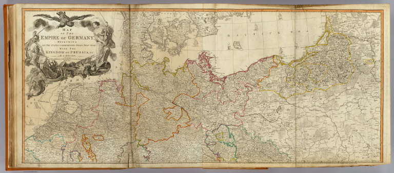
Full Title
Map of the Empire of Germany, including all the states comprehended under that name: with the Kingdom of Prussia, &c. (North half). By L. Delarochette. London, Published by Laurie & Whittle, No. 53, Fleet Street, 12th May, 1794. (T. Kitchin sculpt.)
List No
2310.038
Note
Hand colored engraved map. Relief shown pictorially. Printed on 2 sheets; joined. Contents: The circles of Westphalia and Lower Saxony, with the western parts of the Circle of Upper Saxony, and the northern parts of the Circle of Upper Rhine, part of Sweden, and Denmark; the United Provinces, and part of the Netherlands -- Eastern parts of Brandenburg and Saxony, with Pomerania, Prussia, Lusatia, and the northern parts of Silesia; part of Sweden, Samogitia, Lithuania, and Poland.
Author
Kitchin, Thomas
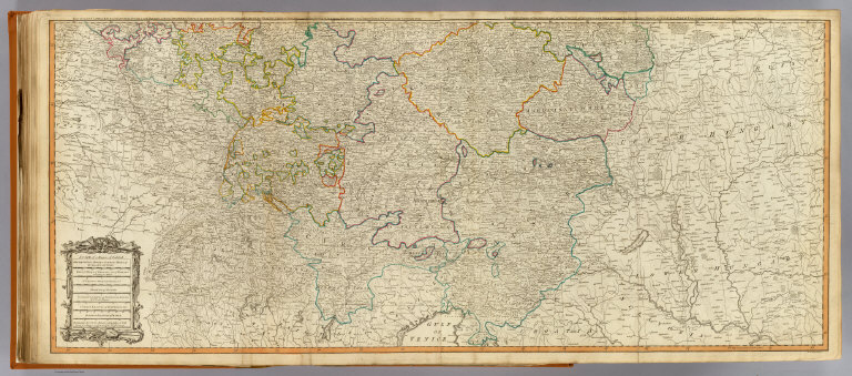
Full Title
(Map of the Empire of Germany, including all the states comprehended under that name: with the Kingdom of Prussia, &c. South half. By L. Delarochette. London, Published by Laurie & Whittle, No. 53, Fleet Street, 12th May, 1794)
List No
2310.039
Note
Hand colored engraved map. Relief shown pictorially. Printed on 2 sheets; joined. Contents: The circles of Lower Rhine, Franconia, Swabia and Bavaria, with the southern parts of the circles of Upper Rhine and Saxony, the western parts of Bohemia and of the circle of Austria, Switzerland and part of Italy, France and the Netherlands -- Eastern parts of Bohemia and of the Circle of Austria, with Moravia, and the southern parts of Silesia; part of Poland, Hungary, Sclavonia, Croatia, and Istria.
Author
[Delarochette, Louis Stanislas d'Arcy, Robert Laurie & James Whittle]
Full Title
(Composite of) Map of the Empire of Germany, including all the states comprehended under that name: with the Kingdom of Prussia, &c. By L. Delarochette. London, Published by Laurie & Whittle, No. 53, Fleet Street, 12th May, 1794. T. Kitchin sculpt.
List No
2310.040
Note
Digital composite of 2 hand colored engraved maps (printed on 4 sheets). Relief shown pictorially. Contents: The circles of Westphalia and Lower Saxony, with the western parts of the Circle of Upper Saxony, and the northern parts of the Circle of Upper Rhine, part of Sweden, and Denmark; the United Provinces, and part of the Netherlands -- Eastern parts of Brandenburg and Saxony, with Pomerania, Prussia, Lusatia, and the northern parts of Silesia; part of Sweden, Samogitia, Lithuania, and Poland -- The circles of Lower Rhine, Franconia, Swabia and Bavaria, with the southern parts of the circles of Upper Rhine and Saxony, the western parts of Bohemia and of the circle of Austria, Switzerland and part of Italy, France and the Netherlands -- Eastern parts of Bohemia and of the Circle of Austria, with Moravia, and the southern parts of Silesia; part of Poland, Hungary, Sclavonia, Croatia, and Istria.
Author
[Jefferys, Thomas, Robert Laurie & James Whittle]
Full Title
The German dominions of the King of Great Britain; comprized under the name of Electorate of Brunswick-Luneburg and including the dutchies of Bremen, Verden, Luneburg-Zell, Calenberg and Grubenhagen. With the counties of Danneberg, Diepholt and Hoya, to which are added the dominions of Brunswick-Wolfenbuttel. By Thomas Jefferys, Geographer to His Majesty. London, Published by Laurie & Whittle, 53, Fleet Street, as the act directs 12th May, 1794.
List No
2310.042
Note
Hand colored engraved map. Relief shown pictorially and by hachures.
Author
Robert Laurie & James Whittle
Full Title
A new map of the Electorate of Bavaria, comprehending the Dutchy of Bavaria, divided into Upper and Lower Bavaria; the Upper Palatinate, the palatinates or dutchies of Neuburg and Sulzbach, the Principality of Mindelheim &c. Published by Laurie & Whittle, 53, Fleet Street, 12th May, 1794.
List No
2310.043
Note
Hand colored engraved map. Relief shown pictorially.
Author
Robert Laurie & James Whittle
Full Title
A map of the Electorate of Brandenburg, including Western Pomerania, and the greatest part of the dutchies of Mecklenburg and Magdeburg. London, Published by Laurie & Whittle, No. 53, Fleet Street, as the act directs 12th May, 1794.
List No
2310.044
Note
Hand colored engraved map. Relief shown by hachures.
Author
[Jefferys, Thomas, Robert Laurie & James Whittle]
Full Title
The Kingdom of Bohemia with the Dutchy of Silesia and the marquisates of Moravia and Lusatia. By Thomas Jefferys, Geographer to the King. London, Published by Laurie & Whittle, 53, Fleet Street, 12th May, 1794.
List No
2310.045
Note
Hand colored engraved map. Relief shown pictorially. Prime meridians: Ferro and London.
1-8 of 8
|