|
REFINE
Browse All : World Atlas by Kitchin, Thomas and Robert Laurie & James Whittle of World
1-5 of 5
Author
[Kitchin, Thomas, Robert Laurie & James Whittle]
Full Title
(Contents to) (A new universal atlas, exhibiting all the empires, kingdoms, states, republics, &c. &c. in the whole World; being a complete collection of the most approved maps extant; corrected with the greatest care, and augmented from the last edition of D'Anville and Robert (de Vaugondy) with many improvements by Major James Rennel, and other eminent geographers, including all the tracks and new discoveries of the British circumnavigators, Biron, Wallis, Carteret, Captain James Cook, Vancouver, Perouse, &c. &c. 6th Ed. ... London, R. Laurie & J. Whittle, 1804)
List No
2310B
Note
60 maps on 76 sheets; lacks title page, has index. Maps dated 1794-1804. Many of the maps are updated from Kitchin's 36 sheet General Atlas, and the American Atlas. In 1796 and 1800 Laurie and Whittle published their New and Elegant Imperial Sheet Atlas (P6009, 6016), with 50 maps all, we believe on a single sheet, with a different map of the U.S. showing the American Flag above the cartouche. The Universal Atlas was their biggest production, with many of the maps multi sheet. Outline color. Atlas is bound in new quarter leather orange cloth covered boards with a red leather label on the spine stamped with "Atlas. Laurie. Whittle." in gilt.
Author
Robert Laurie & James Whittle
Full Title
A new chart of the World on Wright's or Mercator's projection in which are exhibited all the parts hitherto explored or discovered; with the tracks of the British circumnavigators Byron, Wallis, Carteret and Cook, &c. and the track of La Perouse in the Pacific Ocean. Published 25th Novemr. 1800 by Laurie & Whittle, No. 53 Fleet Street, London.
List No
2310.001
Note
Hand colored engraved map. Relief shown pictorially. Printed on 2 sheets; joined.
Author
[Anville, Jean Baptiste Bourguignon d, 1697-1782, Dunn, Samuel, Robert Laurie & James Whittle]
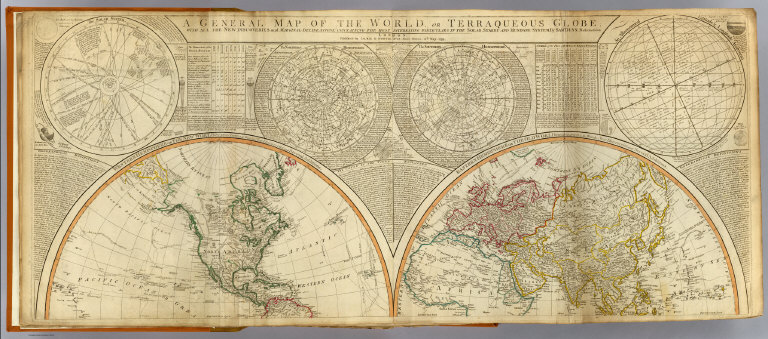
Full Title
A general map of the World or terraqueous globe with all the new discoveries and marginal delineations, containing the most interesting particulars of the solar, starry and mundane system, by Saml. Dunn, mathematician. (North half). London, Published by Laurie & Whittle, No. 53, Fleet Street, 12th May, 1799.
List No
2310.002
Note
Hand colored engraved map. Relief shown pictorially. Contents: Western Hemisphere or the New World by Mr. d'Anville, with new discoveries and several additions -- Eastern Hemisphere or the Old World by Mr. d'Anville, with the new discoveries and several additions. Ancillary maps or charts: The Solar System -- The Northern Hemisphere -- The Southern Hemisphere -- An astronomical latitude & longitude analemma. Printed on 2 sheets; joined.
Author
[Anville, Jean Baptiste Bourguignon d, 1697-1782, Dunn, Samuel, Riccioli, Giovanni Battista, Robert Laurie & James Whittle]
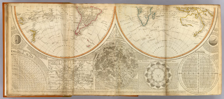
Full Title
(A general map of the World or terraqueous globe with all the new discoveries and marginal delineations, containing the most interesting particulars of the solar, starry and mundane system, by Saml. Dunn, mathematician. South half. London, Published by Laurie & Whittle, No. 53, Fleet Street, 12th May, 1799)
List No
2310.003
Note
Hand colored engraved map. Relief shown pictorially. Contents: Western Hemisphere or the New World by Mr. d'Anville, with new discoveries and several additions -- Eastern Hemisphere or the Old World by Mr. d'Anville, with the new discoveries and several additions. Ancillary maps or charts: An universal scale -- A chart of the World according to Mercator's projection, with the rhumb lines -- Selenography or A map of the Moon according to Father Riccioli -- The vicissitude of seasons explained -- The analemma. Printed on 2 sheets; joined.
Author
[Anville, Jean Baptiste Bourguignon d, 1697-1782, Dunn, Samuel, Riccioli, Giovanni Battista, Robert Laurie & James Whittle]
Full Title
(Composite of) A general map of the World or terraqueous globe with all the new discoveries and marginal delineations, containing the most interesting particulars of the solar, starry and mundane system, by Saml. Dunn, mathematician. London, Published by Laurie & Whittle, No. 53, Fleet Street, 12th May, 1799.
List No
2310.004
Note
Digital composite of north and south halves of hand colored engraved map. Relief shown pictorially. Contents: Western Hemisphere or the New World by Mr. d'Anville, with new discoveries and several additions -- Eastern Hemisphere or the Old World by Mr. d'Anville, with the new discoveries and several additions. Ancillary maps or charts: The Solar System -- The Northern Hemisphere -- The Southern Hemisphere -- An astronomical latitude & longitude analemma -- An universal scale -- A chart of the World according to Mercator's projection, with the rhumb lines -- Selenography or A map of the Moon according to Father Riccioli -- The vicissitude of seasons explained -- The analemma. Printed on 4 sheets; joined as 2.
1-5 of 5
|