|
REFINE
Browse All : World Atlas by Kitchin, Thomas and Jefferys, Thomas from 1790
1-4 of 4
Author
Jefferys, Thomas
Full Title
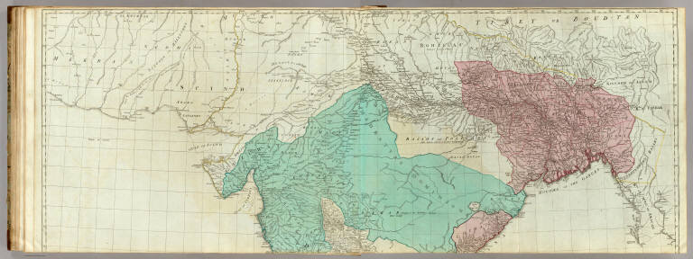
(The East Indies, with the roads. Northern section. By Thomas Jefferys, Geographer to the King. MDCCLXVIII. The second edition. London, published according to Act of Parliament, 30th Apr. 1768 by Robt. Sayer, no. 53 in Fleet Street)
List No
0411.031
Note
Engraved map in outline color. Printed on 2 sheets. Relief shown pictorially. Includes ethnographic and geographic notes. Prime meridians: London and Ferro. "To the directors of the Honble. East India Company, Thos. Jefferys humbly dedicates this map." David Rumsey Collection copy mounted as 1 sheet.
Author
Jefferys, Thomas
Full Title
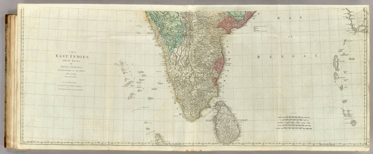
The East Indies, with the roads. (Southern section). By Thomas Jefferys, Geographer to the King. MDCCLXVIII. The second edition. London, published according to Act of Parliament, 30th Apr. 1768 by Robt. Sayer, no. 53 in Fleet Street.
List No
0411.032
Note
Engraved map in outline color. Printed on 2 sheets. Relief shown pictorially. Includes ethnographic and geographic notes. Prime meridians: London and Ferro. "To the directors of the Honble. East India Company, Thos. Jefferys humbly dedicates this map." David Rumsey Collection copy mounted as 1 sheet.
Author
Jefferys, Thomas
Full Title
(Composite of) The East Indies, with the roads. By Thomas Jefferys, Geographer to the King. MDCCLXVIII. The second edition. London, published according to Act of Parliament, 30th Apr. 1768 by Robt. Sayer, no. 53 in Fleet Street.
List No
0411.033
Note
Engraved map in outline color. Printed on 4 sheets. Relief shown pictorially. Includes ethnographic and geographic notes. Prime meridians: London and Ferro. David Rumsey Collection copy mounted as 2 sheets. "To the directors of the Honble. East India Company, Thos. Jefferys humbly dedicates this map." (E 76--E 113/N 28--N 5)
Author
Jefferys, Thomas
Full Title
An exact chart of the River St. Laurence, from Fort Frontenac to the Island of Anticosti, shewing the soundings, rocks, shoals &c. with views of the lands and all necessary instructions for navigating that river to Quebec. To the Rt. Honble. Jno. Montagu, El. of Sandwich, First Lord Commissioner, to the other Honble. Commissioners for executing the office of Lord High Admiral of Great Britain, this chart is most humbly inscribed by their most obedient, most devoted, humble servt. Thos. Jefferys. London, printed for Robt. Sayer, Map & Printseller, no. 53, Fleet Street, as the Act directs, 25 May 1775.
List No
0411.043
Note
Engraved map in outline color. Printed on 2 sheets. Shows channels, anchorages, waterfalls, islands, rocks, shoals, forests, etc. Depths shown by soundings. Inset maps: The Seven Islands Scale [ca. 1:125,000]-- St. Nicholas or English Harbor. Scale [ca. 1:125,000] -- The traverse or passage from Cape Torment into the south channel of Orleans Island. Scale [ca. 1:150,000] -- The Road of Tadousac. Scale [ca. 1:175,000]. Includes profiles, "A view of the lands from Cape Torment to the Butt," and "The Mountains of our Lady of Notre Dame." Map in 2 segments.
1-4 of 4
|