|
REFINE
Browse All : Geology by King, Clarence
1-11 of 11
Author
King, Clarence
Full Title
(Covers to) Engineer Department U.S.A. Geological and Topographical Atlas Accompanying the Report of the Geological Exploration of the Fortieth Parallel Made by the Authority of the Honorable Secretary of War under the direction of Brig. and Brvt. Major General A.A. Humphreys, Chief of Engineers U.S.A. by Clarence King, U.S. Geologist in Charge, 1876. Julius Bien Lith.
List No
0408A
Author
King, Clarence
Full Title
(Title Page to) Engineer Department U.S.A. Geological and Topographical Atlas Accompanying the Report of the Geological Exploration of the Fortieth Parallel Made by the Authority of the Honorable Secretary of War under the direction of Brig. and Brvt. Major General A.A. Humphreys, Chief of Engineers U.S.A. by Clarence King, U.S. Geologist in Charge, 1876. Julius Bien Lith.
List No
0408B
Note
Magnificent, huge atlas showing the area of the 40th Parallel Survey in topographical and geological maps. Wheat notes: "These are pioneer survey maps, and as such are most interesting. Mapping the West in so broad a cross-section had never before been attempted, a portent of things to come." King, at the age of 25, was made Geologist-in-charge of the Survey in 1867. He was formally ordered "to examine and describe the geological structure, geographical condition and natural resources of a belt of country extending from the 120th meridian eastward to the 105th meridian, along the 40th parallel of latitude with sufficient expansion north and south to include the lines of 'Central' and 'Union Pacific' railroads..." (Wheat). The topographical sheets depict features by brush shading rather than hachuring. In original binding -rare. Bound in green half leather with a label on the front, "Geological and Topographical Atlas Accompanying the Report of the Geological Exploration of the Fortieth Parallel. Clarence King, Geologist in Charge."
Author
King, Clarence
Full Title
(Index Page to) Engineer Department U.S.A. Geological and Topographical Atlas Accompanying the Report of the Geological Exploration of the Fortieth Parallel Made by the Authority of the Honorable Secretary of War under the direction of Brig. and Brvt. Major General A.A. Humphreys, Chief of Engineers U.S.A. by Clarence King, U.S. Geologist in Charge, 1876. Julius Bien Lith.
List No
0408C
Note
Index page includes the list of maps and a legend naming the mapmakers and the basis by which the maps were made.
Author
King, Clarence
Full Title
Cordilleras.
List No
0408.001
Note
Map in what came to be known as "plastic shading." The development of halftone lithography made this technique possible. The technique depicts surface features by brush shading rather than the more conventional hachuring. The map is in brown tones with the index maps highlighted in red.
Author
King, Clarence
Full Title
Rocky Mountains. Map I. (Geological)
List No
0408.002
Note
Map in full color with the legends on either side of the maps. Map extends from Cheyenne in the east to Fortification Peak in the west (Wyoming). Below the map are two geologic cross sections.
Author
King, Clarence
Full Title
Green River Basin. Map II. (Geological)
List No
0408.003
Note
Map in full color with the legends on either side of the maps. Map extends from Fortification Peak in Wyoming to Piedmont in Utah. Below the map are two geologic cross sections.
Author
King, Clarence
Full Title
Utah Basin. Map III. (Geological)
List No
0408.004
Note
Map in full color with the legends on either side of the maps. Map extends from Piedmont in Utah to Bovine, Utah including the Great Salt Lake. Below the map are two geologic cross sections.
Author
King, Clarence
Full Title
Nevada Plateau. Map IV. (Geological)
List No
0408.005
Note
Map in full color with the legends on either side of the maps. Map extends from Bovine, Utah across the Nevada plateau to Argenta, Nevada. Below the map are two geologic cross sections.
Author
King, Clarence
Full Title
Nevada Basin. Map V. (Geological)
List No
0408.006
Note
Map in full color with the legends on either side of the maps. Map extends from Argenta, Nevada to the west of Pyramid Lake (Lake Tahoe) in California. Below the map are two geologic cross sections.
Author
King, Clarence
Full Title
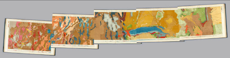
(Composite of) Geological Maps I-V, 40th Parallel Survey.
List No
0408.007
Note
Maps in full color with the legends on either side of the maps.
Author
King, Clarence
Full Title
General Sections.
List No
0408.008
Note
In full color. Ten sections shown with the legends on either side of the cross sections.
1-11 of 11
|