|
Author
Kiepert, Heinrich, 1818-1899
Full Title
(Heinrich Kiepert original manuscripts). 1885.
List No
13116.001
Note
Handwritten letters by German geographer and cartographer Heinrich Kiepert, foremost authority on the geography of Ottoman Empire. The letter dated November 18, 1885 on blue sheets 22x14 or smaller, text addressed to the map published and his personal friend Dietrich Reimer, discussed and untitled map Kiepert was working on in November, 1885, probably one of the maps Kiepert and Reimer published together. The letter dated February 2, 1885 addressed to unknown scientist in Vienna, includes his annotations and remarks to the map of Lycia, a geopolitical region in the southwest part of Anatolia, in Anatalya in Turkey, which was a result of the Austrian archaeological expedition to the region. In the letter Kiepert mentions an archeologist Alexander Christian Leopold Conze, 1931-1914 sent him a map of Lycia. According to the note the expedition brought with them three Kiepert's maps, which were by coincidence tossed overboard off coast of the Island of Kekova.
Author
Kiepert, Heinrich, 1818-1899
Full Title
(Heinrich Kiepert original manuscripts). 1885.
List No
13116.002
Note
Handwritten letters by German geographer and cartographer Heinrich Kiepert, foremost authority on the geography of Ottoman Empire. The letter dated November 18, 1885 on blue sheets 22x14 or smaller, text addressed to the map published and his personal friend Dietrich Reimer, discussed and untitled map Kiepert was working on in November, 1885, probably one of the maps Kiepert and Reimer published together. The letter dated February 2, 1885 addressed to unknown scientist in Vienna, includes his annotations and remarks to the map of Lycia, a geopolitical region in the southwest part of Anatolia, in Anatalya in Turkey, which was a result of the Austrian archaeological expedition to the region. In the letter Kiepert mentions an archeologist Alexander Christian Leopold Conze, 1931-1914 sent him a map of Lycia. According to the note the expedition brought with them three Kiepert's maps, which were by coincidence tossed overboard off coast of the Island of Kekova.
Author
Kiepert, Heinrich, 1818-1899
Full Title
(Heinrich Kiepert original manuscripts). 1885.
List No
13116.003
Note
Handwritten letters by German geographer and cartographer Heinrich Kiepert, foremost authority on the geography of Ottoman Empire. The letter dated November 18, 1885 on blue sheets 22x14 or smaller, text addressed to the map published and his personal friend Dietrich Reimer, discussed and untitled map Kiepert was working on in November, 1885, probably one of the maps Kiepert and Reimer published together. The letter dated February 2, 1885 addressed to unknown scientist in Vienna, includes his annotations and remarks to the map of Lycia, a geopolitical region in the southwest part of Anatolia, in Anatalya in Turkey, which was a result of the Austrian archaeological expedition to the region. In the letter Kiepert mentions an archeologist Alexander Christian Leopold Conze, 1931-1914 sent him a map of Lycia. According to the note the expedition brought with them three Kiepert's maps, which were by coincidence tossed overboard off coast of the Island of Kekova.
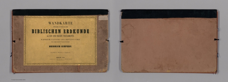
Author
Kiepert, Heinrich, 1818-1899
Full Title
(Covers to) Wandkarte zur Erlauterung der biblischen Erdkunde alten und neuen Testaments. im Auftrage der stadtischen Schuldeputation zu Berlin zum Schulgebrauch bearbeitet von H. Kiepert. Vier blatter. Maasstab 1 : 3,000,000. Berlin, Verlag von Dietrich Reimer. 1872. Lith v. C.L. Ohmann. (inset) Die Wuste zwischen AEgypten und Canaan mit der Halbinsel des Sinai im dreifachen Massstabe der Hauptkarte.
List No
13094.001
Note
Kiepert's school wall map of the biblical geography of the Old and New Testaments, on sheet 98x129 dissected and mounted on linen, folded into covers 32x49, with title pasted on front cover. Includes inset map of the Sinai Peninsula. Map depicts the Near and Middle East during biblical times, extends from Rome to the Persian Gulf and the Red Sea. The Holly Land in the center is shaded in pink. Shows the Twelve Tribes territories dotted with names of numerous cities and locations. The four sets of colored lines mark the travels of Paul the Apostle. Relief shown by shading. Prime meridian is Ferro.
Author
Kiepert, Heinrich, 1818-1899
Full Title
Wandkarte zur Erlauterung der biblischen Erdkunde alten und neuen Testaments. im Auftrage der stadtischen Schuldeputation zu Berlin zum Schulgebrauch bearbeitet von H. Kiepert. Vier blatter. Maasstab 1 : 3,000,000. Berlin, Verlag von Dietrich Reimer. 1872. Lith v. C.L. Ohmann. (inset) Die Wuste zwischen AEgypten und Canaan mit der Halbinsel des Sinai im dreifachen Massstabe der Hauptkarte.
List No
13094.002
Note
Kiepert's school wall map of the biblical geography of the Old and New Testaments, on sheet 98x129 dissected and mounted on linen, folded into covers 32x49, with title pasted on front cover. Includes inset map of the Sinai Peninsula. Map depicts the Near and Middle East during biblical times, extends from Rome to the Persian Gulf and the Red Sea. The Holly Land in the center is shaded in pink. Shows the Twelve Tribes territories dotted with names of numerous cities and locations. The four sets of colored lines mark the travels of Paul the Apostle. Relief shown by shading. Prime meridian is Ferro.
Author
[Kiepert, Heinrich, 1818-1899, Richard Kiepert, 1846 - 1915]
Full Title
Nouvelle carte generale des provinces asiatiques de L'empire Ottoman : sans L'Arabie. Dressee par Henri Kiepert, Berlin. 1883. Berlin, Dietrich Reimer, Editeur 1884. Chemins de fer d'apres l'eat de 1917.
List No
13119.002
Note
1917 edition of map of the Ottoman Empire, covers most of Middle East and part of Near East. Colored on sheet 100x158, dissected into 24 sections, backed with linen, folded to 24x26. with sellers label of Simon Schrop & Co. Berlin on verso reading ""Kiepert l' Empire Ottoman". Map shows administrative divisions, cities, villages, roads, rivers and mountains. Relief shown by shading and spot heights. Prime meridian is Greenwich. Includes list of geographic terms in eastern languages and notes on administrative divisions. Includes notes on materials the cartographer used to put together the map.
Author
Kiepert, Heinrich, 1818-1899
Full Title
(Title/Index Page to) Specialkarte vom westlichen Kleinasien : nach seinen eigenen Reisen und nach anderen grosstenteils noch unveroffentlichten Routenaufnahmen : Bearbeitet von Heinrich Kiepert. Ubersichtsblatt : Provinzen des Osmanischen Reiches = Carte synoptique de la division administrative des provinces de l'Empire Ottoman = Index sheet of the map showing the administrative division of the Ottoman Empire. Berlin 1892. Verlag von Dietrich Reimer. Inhaber: Hoefer & Vohsen. (to accompany) Specialkarte vom westlichen Kleinasien = Carte de la partie occidentale de l'Asie mineure = Map of the western part of Asia minor.
List No
13051.002
Note
Index map of the administrative divisions of the Ottoman Empire. Includes colored key to the provinces. Descriptive text on verso.
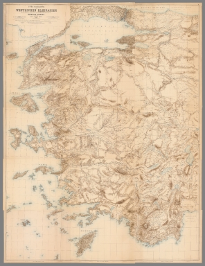
Author
Kiepert, Heinrich, 1818-1899
Full Title
(Composite Map) Specialkarte vom westlichen Kleinasien : nach seinen eigenen Reisen und nach anderen grosstenteils noch unveroffentlichten Routenaufnahmen = Carte de la partie occidentale de l'Asie mineure = Map of the western part of Asia minor. Bearbeitet von Heinrich Kiepert. Massstab 1 : 250,000. Berlin, Dietrich Reimer 1890. Geog. lith. Anst. u. Steindr. v. C.L. Keller.
List No
13051.023
Note
Composite of 15 sheets of the map of the western part of Asia minor.
Author
Kiepert, Heinrich, 1818-1899
Full Title
(Title Page to) Neuer Hand-Atlas uber alle Theile der Erde : Entworfen und bearbeitet von Dr. Heinrich Kiepert. Zweite vollstandig berichtigte und vermehrte Auflage. Berlin Verlag von Dietrich Reimer 1871.
List No
11693.002
Note
The 2nd completely revised and expanded edition, 1871 printing of Kiepert's New Hand Atlas of the entire World. Published by D. Reimer in Berlin. The atlas has a double page engraved title page with the table of contents, printed in light blue, 42 maps, 4 pages of preface and descriptive text and 2 pages of text to the revised map of eastern France. "Berichtigungen zur karte von Ost Frankreich". Maps are hand colored in outline, dated 1866-1870. Showing political and administrative divisions, cities, towns, villages, canals, bridges, roads, rivers and mountains. All maps have names of the engraver or printer. Relief shown by hachures. Prime meridian is Paris. Atlas is bound in half leather, dark green covers with gilt title "Kiepert's Hand-Atlas". Heinrich Kiepert (1818-1899) is known as one of the more important scholarly cartographers of the second half of the 19th century. His Hand Atlas has several additional compilations. The title of the 1st and 2nd editions is "Neuer Hand-Atlas uber alle Theile der Erde". The title of the 3rd edition is "Kiepert's Grosser Hand-Atlas". The 2nd edition published in 2 printings, 1871 and 1877. In the 1871 printing the header of the preface is "Zweite vollstandig berichtigte und erweiterte Auflage." in the 1877 printing the header of preface is "Dritte umgearbeitete und erweiterte Auflage. Neuer berichtigter Abdruck. In 1845 he became a cartographer of the Bertuchian Geographical Institute in Weimar, and in 1852 he moved to Berlin in the same capacity as Dietrich Reimer, and designed maps for the Berlin Society for Geography.
Author
Kiepert, Heinrich, 1818-1899
Full Title
Erdkarte in Mercators Projection mit Bezeichnung der Meeresstromungen. Beriechtigt 1867. Situation u. Schrift gest. von W. Jaeck.Terrain gestochen von W. Bembe. (to accompany) H. Kiepert's Neuer Handatlas No. 1. Berlin BEI Dietrich Reimer.
List No
11693.008
Note
Double page hand colored in outline map. Showing Ocean Currents and Wind, centered on the Pacific basin, the map covers the entire world. Includes legend. Relief shown by hachures. Prime meridians are Ferro and Paris.
Author
Kiepert, Heinrich, 1818-1899
Full Title
Die Nillander. Neue Bearbeitung. Berichtgt 1866. Stich. v. J. Sulzer. Durck v. F. Barth. (to accompany) H. Kiepert's Neuer Handatlas No. 34. Berlin BEI Dietrich Reimer. (inset) Das Nil-Delta.
List No
11693.045
Note
Double page hand colored in outline map. Color coded by political and administrative boundaries. Includes legend and text. Relief shown by hachures. Prime meridians are Ferro, Greenwich and Paris.
Author
[Gerold, Friedrich Karl Joseph von, 1798-1879, Heller, Karl Bartholomaus, 1824-1880, Humboldt, Alexander von, 1769-1859, Kiepert, Heinrich, 1818-1899, Smith, Martin Luther, 1819-1866, Sociedad Mexicana de Geografia y Estadistica]
Full Title
(Covers to) H. Kiepert's Karte des nordlichen tropischen America. A new map of Tropical-America north of the equator comprising the West-Indies, Central-America, Mexico, New Granada and Venezuela. Composed with the help of all cartographic and litterary (sic) materials hitherto published and dedicated by permission to His Excellency Baron Alexander von Humboldt By H. Kiepert, Ph. Dr. M.R., Acad. Berlin, F. Geogr. Soc. of. Berlin, Paris and Vienna. 1858. Published by Dietrich Reimer, Berlin. Lithogr. and printed by C. Monecke, Berlin. Lith. Inst. von C. Monecke in Berlin. (with) Central part of the Mexican Republic ... based on the surveys published by A.v. Humboldt, v. Gerolt, Heller, Smith and the Sociedad Mejicana de Geografia t Estadistica.
List No
0404A
Note
Water is hand painted in full color; countries shown with outline color. Dissected into 60 sections. Map has yellow paper end sheets and folds into a brown cloth covered slip case 21.5x15 with "Map of Tropical America" hand written in white ink on the spine, and a paper label reading "Sir ... McNeill. Tropical America" in ms and "London: Edward Stanford, Wholesale & Retail Mapseller, &c. 55, Charing Cross. Agent By Appointment. Ordnance Maps. Admiralty Charts. Maps, Guide Books, Atlases. Plans" printed in black ink. Relief shown by hachures. Scale of inset map 1:1,000,000. Prime meridians: Ferro and Greenwich.
Author
[Gerold, Friedrich Karl Joseph von, 1798-1879, Heller, Karl Bartholomaus, 1824-1880, Humboldt, Alexander von, 1769-1859, Kiepert, Heinrich, 1818-1899, Smith, Martin Luther, 1819-1866, Sociedad Mexicana de Geografia y Estadistica]
Full Title
H. Kiepert's Karte des nordlichen tropischen America. A new map of Tropical-America north of the equator comprising the West-Indies, Central-America, Mexico, New Granada and Venezuela. Composed with the help of all cartographic and litterary (sic) materials hitherto published and dedicated by permission to His Excellency Baron Alexander von Humboldt By H. Kiepert, Ph. Dr. M.R., Acad. Berlin, F. Geogr. Soc. of. Berlin, Paris and Vienna. 1858. Published by Dietrich Reimer, Berlin. Lithogr. and printed by C. Monecke, Berlin. Lith. Inst. von C. Monecke in Berlin. (with) Central part of the Mexican Republic ... based on the surveys published by A.v. Humboldt, v. Gerolt, Heller, Smith and the Sociedad Mejicana de Geografia t Estadistica.
List No
0404.001
Note
Water is hand painted in full color; countries shown with outline color. Dissected into 60 sections. Map has yellow paper end sheets and folds into a brown cloth covered slip case 21.5x15 with "Map of Tropical America" hand written in white ink on the spine, and a paper label reading "Sir ... McNeill. Tropical America" in ms and "London: Edward Stanford, Wholesale & Retail Mapseller, &c. 55, Charing Cross. Agent By Appointment. Ordnance Maps. Admiralty Charts. Maps, Guide Books, Atlases. Plans" printed in black ink. Relief shown by hachures. Scale of inset map 1:1,000,000. Prime meridians: Ferro and Greenwich.
Author
Kiepert, Heinrich, 1818-1899
Full Title
(Covers to) Atlas antiquus. Zwolf Karten zur alten Geschichte entworfen und bearbeitet von Heinrich Kiepert. Mit Namenverzeichnis. Berlin, Dietrich Reimer (Ernst Vohsen). (1903)
List No
0405A
Note
Light brown cloth covers. "Zwolfte berichtigte Ausgabe." "Drittes hundert tausend."
Author
Kiepert, Heinrich, 1818-1899
Full Title
(Title Page to) Atlas antiquus. Zwolf Karten zur alten Geschichte entworfen und bearbeitet von Heinrich Kiepert. Mit Namenverzeichnis. Berlin, Dietrich Reimer (Ernst Vohsen). (1903)
List No
0405B
Note
1 atlas ([1] leaf, xii folded leaves of plates, [2], 27 p. : 12 col. maps). "Zwolfte berichtigte Ausgabe"--Cover. "Neue berichtigte Ausgabe, 1902"--Namen-Verzeichnis. Latest map revisions dated 1903. Placenames, legends and index in Latin; explanatory material in German. "Drittes hundert tausend"--Cover. Includes contents: 1. Orbis terrarum antiquis notus -- 2. Imperia Persarum et Macedonum -- 3. Aegyptus. Phoenice et Palaestina -- 4. Asia citerior -- 5. Graecia cum insulis et oris maris Aegaei -- 6. Graecia ampliore modulo descripta -- 7. Italia -- 8. Italiae pars media -- 9. Roma urbs -- 10. Hispania, Mauretania et Africa -- 11. Gallia, Britannia, Germania -- 12. Imperium Romanum -- Namenverzeichnis. Light brown cloth covers.
Author
Kiepert, Heinrich, 1818-1899
Full Title
Orbis terrarum altero p. Chr. saeculo antiquis notus. Auctore Henrico Kiepert Berolinensi. (with) Regna orientis antiquissima. (with) Orbis Terrarum secundum Erathoshenem (ca. 200 a. Chr.) (with) Orbis Terrarum secundum Ptolemaeum Alexandrinum (ca. 150 p. Chr.). Geographische Verlagshandlung Dietrich Reimer (Ernst Vohsen) Berlin, Wilhemlstr. 29. (1903)
List No
0405.001
Note
1 color map. Relief shown by hachures. Prime meridian: Ferro.
Author
Kiepert, Heinrich, 1818-1899
Full Title
Imperia Persarum et Macedonum. (with) Regna Diadochorum medio IIIo. a. Chr. saeculo. (with) Regna Graecorum IIo a. Chr. saeculo. Auctore Henrico Kiepert Berolinensi. Geographische Verlagshandlung Dietrich Reimer (Ernst Vohsen) Berlin, Wilhemlstr. 29. (1903)
List No
0405.002
Note
1 color map. Relief shown by hachures.
Author
Kiepert, Heinrich, 1818-1899
Full Title
Aegyptus. Phoenice et Palaestina. (with) Tyrus. (with) Alexandria. (with) XII tribus Israelitarum. (with) Hierosolyma. Auctore H. Kiepert Berolinensi. Geographische Verlagshandlung Dietrich Reimer (Ernst Vohsen) Berlin, Wilhemlstr. 29. (1903)
List No
0405.003
Note
2 color maps. Relief shown by hachures. Prime meridians: Paris and Greenwich. Scale of Phoenice et Palaestina 1:1,250,000.
Author
Kiepert, Heinrich, 1818-1899
Full Title
Asia citerior. Auctore Henrico Kiepert Berolinensi. Geographische Verlagshandlung Dietrich Reimer (Ernst Vohsen) Berlin, Wilhemlstr. 29. (1903)
List No
0405.004
Note
1 color map. Relief shown by hachures. Prime meridian: Paris.
Author
Kiepert, Heinrich, 1818-1899
Full Title
Graecia cum insulis et oris maris Aegaei. (with) Troas et Hellespontus. Auctore Henrico Kiepert Berolinensi. Geographische Verlagshandlung Dietrich Reimer (Ernst Vohsen) Berlin, Wilhemlstr. 29. (1903)
List No
0405.005
Note
1 color map. Relief shown by hachures. Prime meridians: Paris and Greenwich.
Author
Kiepert, Heinrich, 1818-1899
Full Title
Graecia. (with) Athenae. (with) Regiones proximae circa urbem Athenas. Auctore Henrico Kiepert Berolinensi. Geographische Verlagshandlung Dietrich Reimer (Ernst Vohsen) Berlin, Wilhemlstr. 29. IV.1903.
List No
0405.006
Note
1 color map. Relief shown by hachures. Prime meridians: Paris and Greenwich.
Author
Kiepert, Heinrich, 1818-1899
Full Title
Italia. (with) Undecim regiones Italiae ab Augusto Imp. institutae. Auctore Henrico Kiepert Berolinensi. Geographische Verlagshandlung Dietrich Reimer (Ernst Vohsen) Berlin, Wilhemlstr. 29. (1903)
List No
0405.007
Note
1 color map. Relief shown by hachures. Prime meridians: Paris and Greenwich.
Author
Kiepert, Heinrich, 1818-1899
Full Title
Italiae pars media. (with) Magna Graecia sive Italia Inferior cum Sicilia, VIII-V a. Chr. saeculo. (with) Syracusae. (with Neapolis). (with) Latium antiquissimum. Auctore Henrico Kiepert Berolinensi. Geographische Verlagshandlung Dietrich Reimer (Ernst Vohsen) Berlin, Wilhemlstr. 29. (1903)
List No
0405.008
Note
1 color map. Relief shown by hachures. Prime meridians: Paris and Greenwich.
Full Title
Roma urbs ab Augusti Imp. tempore cum muris ab Aureliano et Honorio conditis. (with) Roma urbs tempore liberae reipublicae cum IV regionibus a Ser. Tullio conditis Capitolio et Aventino extra pomerium relictis. (with) Forum Romanum et fora Caesarum cum Capitolio et regione circumiacente quadruplici maioris tabulae modulo descripta. (with) Forum Romanum quo statu tempore liberae reipublicae fuisse videtur. (Auctore Henrico Kiepert Berolinensi). Geographische Verlagshandlung Dietrich Reimer (Ernst Vohsen) Berlin, Wilhemlstr. 29. (1903)
List No
0405.009
Note
1 color map. Relief shown by hachures.
Author
Kiepert, Heinrich, 1818-1899
Full Title
Hispania, Mauretania et Africa. (with) Carthago. (with) Provinciae Carthaginiensibus subditae. Auctore Henrico Kiepert Berolinensi. Geographische Verlagshandlung Dietrich Reimer (Ernst Vohsen) Berlin, Wilhemlstr. 29. X.1901 (1903)
List No
0405.010
Note
1 color map. Relief shown by hachures. Prime meridians: Paris and Greenwich.
Author
Kiepert, Heinrich, 1818-1899
Full Title
Gallia, Britannia, Germania, Provinciae danuvienses. Auctore Henrico Kiepert Berolinensi. Geographische Verlagshandlung Dietrich Reimer (Ernst Vohsen) Berlin, Wilhemlstr. 29. IV.1903.
List No
0405.011
Note
1 color map. Relief shown by hachures. Includes inset. Prime meridians: Greenwich and Paris.
Author
Kiepert, Heinrich, 1818-1899
Full Title
Imperium Romanum. (with) Imperium Romanum in praefecturas, dioceses, provincias divisum. Auctore Henrico Kiepert Berolinensi. Geographische Verlagshandlung Dietrich Reimer (Ernst Vohsen) Berlin, Wilhemlstr. 29. (1903)
List No
0405.012
Note
1 color map. Relief shown by hachures.
Author
[Kiepert, Heinrich, 1818-1899, Ohmann, Carl Ludwig]
Full Title
Sheet 1 Erdkarte in Mercators Projection
List No
10104.001
Note
1 map 96x161, in eight sheets. Engraved map, continents in outline hand color. Shows ocean currents, countries, major cities, rivers and mountains. Relief shown by hachures. Prime meridians are Greenwich, Paris and Ferro. See our 11679.000 for a dissected version of this map.
Author
[Kiepert, Heinrich, 1818-1899, Ohmann, Carl Ludwig]
Full Title
Sheet 2 Erdkarte in Mercators Projection
List No
10104.002
Note
1 map 96x161, in eight sheets. Engraved map, continents in outline hand color. Shows ocean currents, countries, major cities, rivers and mountains. Relief shown by hachures. Prime meridians are Greenwich, Paris and Ferro. See our 11679.000 for a dissected version of this map.
Author
[Kiepert, Heinrich, 1818-1899, Ohmann, Carl Ludwig]
Full Title
Sheet 3 Erdkarte in Mercators Projection
List No
10104.003
Note
1 map 96x161, in eight sheets. Engraved map, continents in outline hand color. Shows ocean currents, countries, major cities, rivers and mountains. Relief shown by hachures. Prime meridians are Greenwich, Paris and Ferro. See our 11679.000 for a dissected version of this map.
Author
[Kiepert, Heinrich, 1818-1899, Ohmann, Carl Ludwig]
Full Title
Sheet 4 Erdkarte in Mercators Projection
List No
10104.004
Note
1 map 96x161, in eight sheets. Engraved map, continents in outline hand color. Shows ocean currents, countries, major cities, rivers and mountains. Relief shown by hachures. Prime meridians are Greenwich, Paris and Ferro. See our 11679.000 for a dissected version of this map.
Author
[Kiepert, Heinrich, 1818-1899, Ohmann, Carl Ludwig]
Full Title
Sheet 5 Erdkarte in Mercators Projection
List No
10104.005
Note
1 map 96x161, in eight sheets. Engraved map, continents in outline hand color. Shows ocean currents, countries, major cities, rivers and mountains. Relief shown by hachures. Prime meridians are Greenwich, Paris and Ferro. See our 11679.000 for a dissected version of this map.
Author
[Kiepert, Heinrich, 1818-1899, Ohmann, Carl Ludwig]
Full Title
Sheet 6 Erdkarte in Mercators Projection
List No
10104.006
Note
1 map 96x161, in eight sheets. Engraved map, continents in outline hand color. Shows ocean currents, countries, major cities, rivers and mountains. Relief shown by hachures. Prime meridians are Greenwich, Paris and Ferro. See our 11679.000 for a dissected version of this map.
Author
[Kiepert, Heinrich, 1818-1899, Ohmann, Carl Ludwig]
Full Title
Sheet 7 Erdkarte in Mercators Projection
List No
10104.007
Note
1 map 96x161, in eight sheets. Engraved map, continents in outline hand color. Shows ocean currents, countries, major cities, rivers and mountains. Relief shown by hachures. Prime meridians are Greenwich, Paris and Ferro. See our 11679.000 for a dissected version of this map.
Author
[Kiepert, Heinrich, 1818-1899, Ohmann, Carl Ludwig]
Full Title
Sheet 8 Erdkarte in Mercators Projection
List No
10104.008
Note
1 map 96x161, in eight sheets. Engraved map, continents in outline hand color. Shows ocean currents, countries, major cities, rivers and mountains. Relief shown by hachures. Prime meridians are Greenwich, Paris and Ferro. See our 11679.000 for a dissected version of this map.
Author
[Kiepert, Heinrich, 1818-1899, Ohmann, Carl Ludwig]
Full Title
(Composite map of) Sheets 1-8 Erdkarte in Mercators Projection
List No
10104.009
Note
Composite of sheets 1 through 8. 1 map 96x161, in eight sheets. Engraved map, continents in outline hand color. Shows ocean currents, countries, major cities, rivers and mountains. Relief shown by hachures. Prime meridians are Greenwich, Paris and Ferro. See our 11679.000 for a dissected version of this map.
Author
[Kiepert, Heinrich, 1818-1899, Delius, H.]
Full Title
(Covers to) Karte des Turkischen Reichs in Asien : nach den besten und neuesten Hulfsmitteln ... Entworfen und gezeichnet von H. Kiepert. Neue berichtigte Ausgabe. Berlin, Stich u. Druck von H. Delius. Verlag v. S. Schropp u. Comp. 1853.
List No
11669.001
Note
New and revised edition map of the Ottoman Empire. Outline hand color map on sheet 63x90 dissected into 25 sections, with end sheet of publisher's advertisement, folds into brown marbled slip cover, placed into cardboard slip case 19x13, with title "Asiatische Turkey" in gold on spine. Map shows political and administrative boundaries, regions, rivers, lakes, mountains, cities and towns. Includes notes and translation of geographical terms in Turkish, Persian and Arabic. Relief shown by hachures.
Author
[Kiepert, Heinrich, 1818-1899, Delius, H.]
Full Title
(Advertisement to) Karte des Turkischen Reichs in Asien : nach den besten und neuesten Hulfsmitteln ... Entworfen und gezeichnet von H. Kiepert. Neue berichtigte Ausgabe. Berlin, Stich u. Druck von H. Delius. Verlag v. S. Schropp u. Comp. 1853.
List No
11669.002
Note
New and revised edition map of the Ottoman Empire. Outline hand color map on sheet 63x90 dissected into 25 sections, with end sheet of publisher's advertisement, folds into brown marbled slip cover, placed into cardboard slip case 19x13, with title "Asiatische Turkey" in gold on spine. Map shows political and administrative boundaries, regions, rivers, lakes, mountains, cities and towns. Includes notes and translation of geographical terms in Turkish, Persian and Arabic. Relief shown by hachures.
Author
[Kiepert, Heinrich, 1818-1899, Delius, H.]
Full Title
Karte des Turkischen Reichs in Asien : nach den besten und neuesten Hulfsmitteln ... Entworfen und gezeichnet von H. Kiepert. Neue berichtigte Ausgabe. Berlin, Stich u. Druck von H. Delius. Verlag v. S. Schropp u. Comp. 1853.
List No
11669.004
Note
New and revised edition map of the Ottoman Empire. Outline hand color map on sheet 63x90 dissected into 25 sections, with end sheet of publisher's advertisement, folds into brown marbled slip cover, placed into cardboard slip case 19x13, with title "Asiatische Turkey" in gold on spine. Map shows political and administrative boundaries, regions, rivers, lakes, mountains, cities and towns. Includes notes and translation of geographical terms in Turkish, Persian and Arabic. Relief shown by hachures.
Author
Kiepert, Heinrich, 1818-1899
Full Title
(Covers to) General-Karte von der Europaischen Turkei. Nach Allen Vorhandenen Originalkarten und Iterarischen Hulfsmitteln Bearbeitet und Gezeichnet von Heinrich Kierpert. Scheift gestochen von W. u. C Kratz. in Weimar. Berlin, in commission Bei Dietrich Reimer, 1853. Terrain radirt von C. Ohmann in Berlin. (insets) Das Wladikat Zrnagora oder Montenegro. (with) Das befestigte sudliche Theil der Dardanellen Strasse. (with) Constantinopel und der Bosporus.
List No
11671.001
Note
General map of European Turkey. Edited and Drawn by Heinrich Kierpert. 1 map on 4 sheets, each sheet in 4 sections folded into brown cloth case 34x24.5, with title "Turkey in Europe" pasted on the front cover, with accompanied 8 pages of explanatory text by Heinrich Kiepert "Erlauterungen zur general karte der Europaischen Turkie ..." Map engraved by W. u. C Kratz in Weimar, in commission By Dietrich Reimer, 1853. Terrain by Carl Ohmann in Berlin. Map shows political and administrative boundaries, regions, rivers, lakes, mountains, cities, towns, major roads, railroads, etc. Relief shown by hachures.
Author
Kiepert, Heinrich, 1818-1899
Full Title
(Covers to) General-Karte von der Europaischen Turkei. Nach Allen Vorhandenen Originalkarten und Iterarischen Hulfsmitteln Bearbeitet und Gezeichnet von Heinrich Kierpert. Scheift gestochen von W. u. C Kratz. in Weimar. Berlin, in commission Bei Dietrich Reimer, 1853. Terrain radirt von C. Ohmann in Berlin. (insets) Das Wladikat Zrnagora oder Montenegro. (with) Das befestigte sudliche Theil der Dardanellen Strasse. (with) Constantinopel und der Bosporus.
List No
11671.002
Note
General map of European Turkey. Edited and Drawn by Heinrich Kierpert. 1 map on 4 sheets, each sheet in 4 sections folded into brown cloth case 34x24.5, with title "Turkey in Europe" pasted on the front cover, with accompanied 8 pages of explanatory text by Heinrich Kiepert "Erlauterungen zur general karte der Europaischen Turkie ..." Map engraved by W. u. C Kratz in Weimar, in commission By Dietrich Reimer, 1853. Terrain by Carl Ohmann in Berlin. Map shows political and administrative boundaries, regions, rivers, lakes, mountains, cities, towns, major roads, railroads, etc. Relief shown by hachures.
Author
Kiepert, Heinrich, 1818-1899
Full Title
(Text page to) General-Karte von der Europaischen Turkei. Nach Allen Vorhandenen Originalkarten und Iterarischen Hulfsmitteln Bearbeitet und Gezeichnet von Heinrich Kierpert. Scheift gestochen von W. u. C Kratz. in Weimar. Berlin, in commission Bei Dietrich Reimer, 1853. Terrain radirt von C. Ohmann in Berlin. (insets) Das Wladikat Zrnagora oder Montenegro. (with) Das befestigte sudliche Theil der Dardanellen Strasse. (with) Constantinopel und der Bosporus.
List No
11671.003
Note
General map of European Turkey. Edited and Drawn by Heinrich Kierpert. 1 map on 4 sheets, each sheet in 4 sections folded into brown cloth case 34x24.5, with title "Turkey in Europe" pasted on the front cover, with accompanied 8 pages of explanatory text by Heinrich Kiepert "Erlauterungen zur general karte der Europaischen Turkie ..." Map engraved by W. u. C Kratz in Weimar, in commission By Dietrich Reimer, 1853. Terrain by Carl Ohmann in Berlin. Map shows political and administrative boundaries, regions, rivers, lakes, mountains, cities, towns, major roads, railroads, etc. Relief shown by hachures.
Author
Kiepert, Heinrich, 1818-1899
Full Title
(Text page to) General-Karte von der Europaischen Turkei. Nach Allen Vorhandenen Originalkarten und Iterarischen Hulfsmitteln Bearbeitet und Gezeichnet von Heinrich Kierpert. Scheift gestochen von W. u. C Kratz. in Weimar. Berlin, in commission Bei Dietrich Reimer, 1853. Terrain radirt von C. Ohmann in Berlin. (insets) Das Wladikat Zrnagora oder Montenegro. (with) Das befestigte sudliche Theil der Dardanellen Strasse. (with) Constantinopel und der Bosporus.
List No
11671.004
Note
General map of European Turkey. Edited and Drawn by Heinrich Kierpert. 1 map on 4 sheets, each sheet in 4 sections folded into brown cloth case 34x24.5, with title "Turkey in Europe" pasted on the front cover, with accompanied 8 pages of explanatory text by Heinrich Kiepert "Erlauterungen zur general karte der Europaischen Turkie ..." Map engraved by W. u. C Kratz in Weimar, in commission By Dietrich Reimer, 1853. Terrain by Carl Ohmann in Berlin. Map shows political and administrative boundaries, regions, rivers, lakes, mountains, cities, towns, major roads, railroads, etc. Relief shown by hachures.
Author
Kiepert, Heinrich, 1818-1899
Full Title
(Text page to) General-Karte von der Europaischen Turkei. Nach Allen Vorhandenen Originalkarten und Iterarischen Hulfsmitteln Bearbeitet und Gezeichnet von Heinrich Kierpert. Scheift gestochen von W. u. C Kratz. in Weimar. Berlin, in commission Bei Dietrich Reimer, 1853. Terrain radirt von C. Ohmann in Berlin. (insets) Das Wladikat Zrnagora oder Montenegro. (with) Das befestigte sudliche Theil der Dardanellen Strasse. (with) Constantinopel und der Bosporus.
List No
11671.005
Note
General map of European Turkey. Edited and Drawn by Heinrich Kierpert. 1 map on 4 sheets, each sheet in 4 sections folded into brown cloth case 34x24.5, with title "Turkey in Europe" pasted on the front cover, with accompanied 8 pages of explanatory text by Heinrich Kiepert "Erlauterungen zur general karte der Europaischen Turkie ..." Map engraved by W. u. C Kratz in Weimar, in commission By Dietrich Reimer, 1853. Terrain by Carl Ohmann in Berlin. Map shows political and administrative boundaries, regions, rivers, lakes, mountains, cities, towns, major roads, railroads, etc. Relief shown by hachures.
Author
Kiepert, Heinrich, 1818-1899
Full Title
(Text page to) General-Karte von der Europaischen Turkei. Nach Allen Vorhandenen Originalkarten und Iterarischen Hulfsmitteln Bearbeitet und Gezeichnet von Heinrich Kierpert. Scheift gestochen von W. u. C Kratz. in Weimar. Berlin, in commission Bei Dietrich Reimer, 1853. Terrain radirt von C. Ohmann in Berlin. (insets) Das Wladikat Zrnagora oder Montenegro. (with) Das befestigte sudliche Theil der Dardanellen Strasse. (with) Constantinopel und der Bosporus.
List No
11671.006
Note
General map of European Turkey. Edited and Drawn by Heinrich Kierpert. 1 map on 4 sheets, each sheet in 4 sections folded into brown cloth case 34x24.5, with title "Turkey in Europe" pasted on the front cover, with accompanied 8 pages of explanatory text by Heinrich Kiepert "Erlauterungen zur general karte der Europaischen Turkie ..." Map engraved by W. u. C Kratz in Weimar, in commission By Dietrich Reimer, 1853. Terrain by Carl Ohmann in Berlin. Map shows political and administrative boundaries, regions, rivers, lakes, mountains, cities, towns, major roads, railroads, etc. Relief shown by hachures.
Author
Kiepert, Heinrich, 1818-1899
Full Title
(Text page to) General-Karte von der Europaischen Turkei. Nach Allen Vorhandenen Originalkarten und Iterarischen Hulfsmitteln Bearbeitet und Gezeichnet von Heinrich Kierpert. Scheift gestochen von W. u. C Kratz. in Weimar. Berlin, in commission Bei Dietrich Reimer, 1853. Terrain radirt von C. Ohmann in Berlin. (insets) Das Wladikat Zrnagora oder Montenegro. (with) Das befestigte sudliche Theil der Dardanellen Strasse. (with) Constantinopel und der Bosporus.
List No
11671.007
Note
General map of European Turkey. Edited and Drawn by Heinrich Kierpert. 1 map on 4 sheets, each sheet in 4 sections folded into brown cloth case 34x24.5, with title "Turkey in Europe" pasted on the front cover, with accompanied 8 pages of explanatory text by Heinrich Kiepert "Erlauterungen zur general karte der Europaischen Turkie ..." Map engraved by W. u. C Kratz in Weimar, in commission By Dietrich Reimer, 1853. Terrain by Carl Ohmann in Berlin. Map shows political and administrative boundaries, regions, rivers, lakes, mountains, cities, towns, major roads, railroads, etc. Relief shown by hachures.
Author
Kiepert, Heinrich, 1818-1899
Full Title
North West Sheet General-Karte von der Europaischen Turkei. Nach Allen Vorhandenen Originalkarten und Iterarischen Hulfsmitteln Bearbeitet und Gezeichnet von Heinrich Kierpert. Scheift gestochen von W. u. C Kratz. in Weimar. Berlin, in commission Bei Dietrich Reimer, 1853. Terrain radirt von C. Ohmann in Berlin. (insets) Das Wladikat Zrnagora oder Montenegro. (with) Das befestigte sudliche Theil der Dardanellen Strasse. (with) Constantinopel und der Bosporus.
List No
11671.008
Note
General map of European Turkey. Edited and Drawn by Heinrich Kierpert. 1 map on 4 sheets, each sheet in 4 sections folded into brown cloth case 34x24.5, with title "Turkey in Europe" pasted on the front cover, with accompanied 8 pages of explanatory text by Heinrich Kiepert "Erlauterungen zur general karte der Europaischen Turkie ..." Map engraved by W. u. C Kratz in Weimar, in commission By Dietrich Reimer, 1853. Terrain by Carl Ohmann in Berlin. Map shows political and administrative boundaries, regions, rivers, lakes, mountains, cities, towns, major roads, railroads, etc. Relief shown by hachures.
Author
Kiepert, Heinrich, 1818-1899
Full Title
North East Sheet General-Karte von der Europaischen Turkei. Nach Allen Vorhandenen Originalkarten und Iterarischen Hulfsmitteln Bearbeitet und Gezeichnet von Heinrich Kierpert. Scheift gestochen von W. u. C Kratz. in Weimar. Berlin, in commission Bei Dietrich Reimer, 1853. Terrain radirt von C. Ohmann in Berlin. (insets) Das Wladikat Zrnagora oder Montenegro. (with) Das befestigte sudliche Theil der Dardanellen Strasse. (with) Constantinopel und der Bosporus.
List No
11671.009
Note
General map of European Turkey. Edited and Drawn by Heinrich Kierpert. 1 map on 4 sheets, each sheet in 4 sections folded into brown cloth case 34x24.5, with title "Turkey in Europe" pasted on the front cover, with accompanied 8 pages of explanatory text by Heinrich Kiepert "Erlauterungen zur general karte der Europaischen Turkie ..." Map engraved by W. u. C Kratz in Weimar, in commission By Dietrich Reimer, 1853. Terrain by Carl Ohmann in Berlin. Map shows political and administrative boundaries, regions, rivers, lakes, mountains, cities, towns, major roads, railroads, etc. Relief shown by hachures.
Author
Kiepert, Heinrich, 1818-1899
Full Title
South West Sheet General-Karte von der Europaischen Turkei. Nach Allen Vorhandenen Originalkarten und Iterarischen Hulfsmitteln Bearbeitet und Gezeichnet von Heinrich Kierpert. Scheift gestochen von W. u. C Kratz. in Weimar. Berlin, in commission Bei Dietrich Reimer, 1853. Terrain radirt von C. Ohmann in Berlin. (insets) Das Wladikat Zrnagora oder Montenegro. (with) Das befestigte sudliche Theil der Dardanellen Strasse. (with) Constantinopel und der Bosporus.
List No
11671.010
Note
General map of European Turkey. Edited and Drawn by Heinrich Kierpert. 1 map on 4 sheets, each sheet in 4 sections folded into brown cloth case 34x24.5, with title "Turkey in Europe" pasted on the front cover, with accompanied 8 pages of explanatory text by Heinrich Kiepert "Erlauterungen zur general karte der Europaischen Turkie ..." Map engraved by W. u. C Kratz in Weimar, in commission By Dietrich Reimer, 1853. Terrain by Carl Ohmann in Berlin. Map shows political and administrative boundaries, regions, rivers, lakes, mountains, cities, towns, major roads, railroads, etc. Relief shown by hachures.
Author
Kiepert, Heinrich, 1818-1899
Full Title
South East Sheet General-Karte von der Europaischen Turkei. Nach Allen Vorhandenen Originalkarten und Iterarischen Hulfsmitteln Bearbeitet und Gezeichnet von Heinrich Kierpert. Scheift gestochen von W. u. C Kratz. in Weimar. Berlin, in commission Bei Dietrich Reimer, 1853. Terrain radirt von C. Ohmann in Berlin. (insets) Das Wladikat Zrnagora oder Montenegro. (with) Das befestigte sudliche Theil der Dardanellen Strasse. (with) Constantinopel und der Bosporus.
List No
11671.011
Note
General map of European Turkey. Edited and Drawn by Heinrich Kierpert. 1 map on 4 sheets, each sheet in 4 sections folded into brown cloth case 34x24.5, with title "Turkey in Europe" pasted on the front cover, with accompanied 8 pages of explanatory text by Heinrich Kiepert "Erlauterungen zur general karte der Europaischen Turkie ..." Map engraved by W. u. C Kratz in Weimar, in commission By Dietrich Reimer, 1853. Terrain by Carl Ohmann in Berlin. Map shows political and administrative boundaries, regions, rivers, lakes, mountains, cities, towns, major roads, railroads, etc. Relief shown by hachures.
|