|
Author
Stieler, Adolf, 1775–1836
Full Title
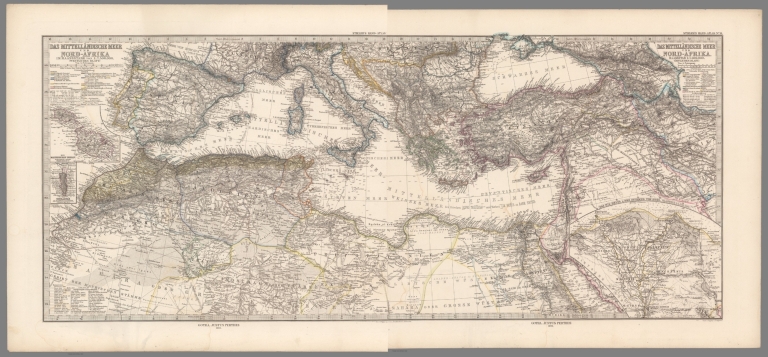
(Composite of) Das Mittellandische Meer Und Nord-Afrika Im Maassstabe von 1:7.500.000. Von A. Petermann. Stieler's Hand-Atlas. Von A. Petermann. Gotha : Justus Perthes. 1875.
List No
13563.021
Note
Composite map of nos. 13-14 of Mediterranean region, Southern Europe and Northern Africa and Southwest Asia. Three inset maps show Malta, Gibraltar, and the Nile Delta and Isthmus of Suez.
Author
Habenicht, Hermann
Full Title
(Composite Map) Spezial-Karte von Afrika ... Entworfen von Hermann Habenicht ... Justus Perthes in Gotha September 1885.
List No
13218.042
Note
Composite of 12 folding maps of Africa.
Author
[Stieler, Adolf, Barich, C.]
Full Title
68. Afrika.
List No
0961.150
Author
[Stieler, Adolf, Barich, C.]
Full Title
Nr. 68. Afrika. ... C. Barich.
List No
0962.150
Author
[Stieler, Adolf, Dormann, B.]
Full Title
Nr. 69. Afrika, Bl. 1. .... B. Dormann.
List No
0962.152
Author
[Stieler, Adolf, Barich, C.]
Full Title
Nr. 70. Afrika, Bl. 2. ... C. Barich.
List No
0962.154
Author
[Stieler, Adolf, Domann, C.]
Full Title
Nr. 71. Afrika, Bl. 3. ... B. Domann. (insets) Das Kuestenland von Ober-Guinea. Der Untere Kongo. West-Kamerun.
List No
0962.156
Author
[Stieler, Adolf, Barich, C.]
Full Title
Nr. 72. Afrika, Bl. 4. ... von C. Barich.
List No
0962.158
Author
[Stieler, Adolf, Habenicht, H.]
Full Title
Nr. 73. Afrika, Bl. 5. ... von H. Habenicht.
List No
0962.160
Author
[Stieler, Adolf, Habenicht, H.]
Full Title
Nr. 74. Afrika, Bl. 6. ... von H. Habenicht. Kapland und Angrezende Gebiete.
List No
0962.162
Author
[Stieler, Adolf, Habenicht, H.]
Full Title
Nr. 75. Afrika, Bl. 7. ... von H. Habenicht.
List No
0962.164
Author
[Stieler, Adolf, Habenicht, H.]
Full Title
(Composite Map) Nr. 69-75. Afrika in 7 Blaettern. ... von H. Habenicht.
List No
0962.165
Author
Stieler, Adolf
Full Title
Afrika : meist nach Berghaus von H. Hubbe. 1828. Berichtigt nach Lander u. nach Douville 1834. Gestochen von John: Carl Ausfeld, in Schnepfenthal bey Gotha. (on upper right margin) Stielers Hand Atlas No. 40. (to accompany) Hand-Atlas uber alle Theile der Erde, nach dem neuesten Zustande und uber das Weltgebaude. (insets) Die Sudspitze von Afrika ; Die Capstadt und Umgebung.
List No
10777.053
Note
Engraved hand colored outline map with two insets. Color–coded to show the European possessions. Shows regions and countries. Relief shown by hachure.
Author
[Stieler, Adolf, Habenicht, H.]
Full Title
65. Afrika. (inset) Ost-Afrika. Ascension.
List No
12240.078
Author
[Stieler, Adolf, Lueddecke, Dr. R.]
Full Title
(Composite Map) 66-71. Afrika in 6 Blaettern, Blatt 1-6.
List No
12240.085
Author
[Stieler, Adolf, Haack, H.]
Full Title
78. Afrika.
List No
12248.165
Author
Habenicht, Hermann
Full Title
Justus Perthes (10 Blatt) Sektion Central Sahara (2). Bearbeitet u. autographirt v. B. Domann. (to accompany) Spezial-Karte von Afrika ... ... Entworfen von Hermann Habenicht ... Justus Perthes in Gotha September 1885.
List No
13218.012
Note
Color map. Relief shown by shading, hachures and spot heights. Prime meridian is Greenwich.
Author
Habenicht, Hermann
Full Title
(Title Page to) Spezial-Karte von Afrika im Massstab von 1: 4,000,000. (10 Blatt.) Entworfen von Hermann Habenicht ; bearbeitet von demselben, Bruno Domann und Dr. Richard Luddecke. Justus Perthes in Gotha September 1885. Spezial-Karte von Afrika ... Sektion Agypten (3). Aut. von C. Barich und P. Ihle.
List No
13218.013
Note
Title page, with color map. Relief shown by shading, hachures and spot heights. Prime meridian is Greenwich. Includes legend and text.
Author
Habenicht, Hermann
Full Title
(Text Page to) Spezial-Karte von Afrika ... Sektion 4: West-Sudan. Bearbeitet von demselben, Bruno Domann ... Entworfen von Hermann Habenicht ... Justus Perthes in Gotha September 1885.
List No
13218.016
Note
Continues: Section 4: Descriptive text.
Author
Habenicht, Hermann
Full Title
Justus Perthes (10 Blatt) Sektion West-Sudan (4). Bearbeitet v. B. Domannu, autographirt von C. Barich. (to accompany) Spezial-Karte von Afrika ... ... Entworfen von Hermann Habenicht ... Justus Perthes in Gotha September 1885.
List No
13218.017
Note
Color map. Relief shown by shading, hachures and spot heights. Prime meridian is Greenwich.
Author
Habenicht, Hermann
Full Title
Justus Perthes (10 Blatt) Sektion Central-Sudan (5). Bearbeitet von Herm. Habenich.(to accompany) Spezial-Karte von Afrika ... ... Entworfen von Hermann Habenicht ... Justus Perthes in Gotha September 1885.
List No
13218.020
Note
Color map. Relief shown by shading, hachures and spot heights. Prime meridian is Greenwich.
Author
Habenicht, Hermann
Full Title
Justus Perthes (10 Bl) Sektion Abessinien (6). Bearbeitet von H. Habenicht. Lith v. P. Ihle. (to accompany) Spezial-Karte von Afrika ... ... Entworfen von Hermann Habenicht ... Justus Perthes in Gotha September 1885.
List No
13218.024
Note
Color map of Ethiopian Empire. Relief shown by shading, hachures and spot heights. Prime meridian is Greenwich.
Author
Habenicht, Hermann
Full Title
Justus Perthes (10 Blatt) Sek. Congo (7). Bearbeitet von H. Habenicht. (to accompany) Spezial-Karte von Afrika ... ... Entworfen von Hermann Habenicht ... Justus Perthes in Gotha September 1885.
List No
13218.028
Note
Color map. Relief shown by shading, hachures and spot heights. Prime meridian is Greenwich.
Author
Habenicht, Hermann
Full Title
(Text Page to) Spezial-Karte von Afrika ... Sektion 8: Seengebiet. Bearbeitet von Dr. Richard Luddecke. Justus Perthes in Gotha September 1885.
List No
13218.031
Note
Continues: Section 8: Descriptive text.
Author
Habenicht, Hermann
Full Title
Justus Perthes (10 Blatt) Supplement I. Hohen- und Tiefen-Übersicht von Afrika. Entworfen von H. Habenicht gez. von C. Barich. Gedruckt in Gotha 1886. (to accompany) Spezial-Karte von Afrika ... Entworfen von Hermann Habenicht ... Justus Perthes in Gotha September 1885.
List No
13218.040
Note
Physical map of Africa. Relief shown by gradient tints and spot heights. Depths shown by bathymetric tints. Prime meridian is Greenwich. Includes color coded key to height of the mountains and depth of the sea.
Author
Habenicht, Hermann
Full Title
Justus Perthes (10 Blatt) Supplement II. Ethnographische Übersicht von Afrika mit Berucksichtigung v. Kultur-u. Eingebornen-Staaten ... Entworfen von H. Habenicht gez. von C. Barich. Gedruckt in Gotha 1886. (to accompany) Spezial-Karte von Afrika ... Entworfen von Hermann Habenicht ... Justus Perthes in Gotha September 1885.
List No
13218.041
Note
Ethnographic map of Africa with consideration of. Cultural and community. Native States. Relief shown by gradient tints and spot heights. Depths shown by soundings and isolines. Prime meridian is Greenwich. Includes note on languages spoken in Africa.
Author
France. Ministere de l'instruction publique
Full Title
L' Afiques en 1890 : Carte extraite de l'Atlas de geographie moderne : Dresse sous la direction de MM. F. Schrader, F. Prudent et E. Anthoine. Grave par Erhard Fres, Paris. Imp. Erhard Fres. Paris. Librairie Hachette & Cie. (on verso) Itineraire du Voyage de Capitaine Binger : de Niambouambo à Waghadougou et a Yendi. L. Thuillier, del. S. Krakow, sc.
List No
13218.043
Note
Color map issued an advertisement for L'atlas de geographie moderne, supplement to "Journal des Debats, Politiques et literaires" Jeudi 19 Mars 1891 supplement illustre. Shows roads, railroads, political boundaries, rivers and mountains. Includes legend and color coded key to possessions of European in Africa. Relief shown by hachures. On verso descriptive text and map, shows Captain Binger's exploration routes in West Africa.
Author
Thuillier, Louis
Full Title
Itineraire du Voyage de Capitaine Binger : de Niambouambo à Waghadougou et a Yendi. L. Thuillier, del. S. Krakow, sc. (on verso) L' Afiques en 1890 : Carte extraite de l'Atlas de geographie moderne : Dresse sous la direction de MM. F. Schrader, F. Prudent et E. Anthoine. Grave par Erhard Fres, Paris. Imp. Erhard Fres. Paris. Librairie Hachette & Cie.
List No
13218.044
Note
Map and text issued an advertisement for L'atlas de geographie moderne, supplement to "Journal des Debats, Politiques et literaires" Jeudi 19 Mars 1891 supplement illustre. On verso descriptive text and map. Shows roads, railroads, political boundaries, rivers and mountains. Includes legend and color coded key to possessions of European in Africa. Relief shown by hachures.
Author
France. Ministere de l'instruction publique
Full Title
Madagascar : esquisse pour suivre les itineraires de M. Mrs. le Dr. Catat, Maistre et Foucart (mission du Ministère de l'instruction publique) 1889-1890. Rougeron. Vignerot Sc.
List No
13218.045
Note
Map, showing the routes of Mr. Mrs. Dr. Catat, Maistre and Foucart (mission of the Ministry of Public Instruction) 1889-1890, issued as supplement to "Journal des Debats du Mardi 24 Mars 1891". Map shows exploration routes. Includes legend. Relief shown by hachures.
Author
[Sydow, Emil von., 1812-1873, Wagner, Hermann, 1840-1929]
Full Title
Afrika : Ubersicht des Relief und der politischen Verhaltnisse. Gotha : Justus Perthes. Sydow-Wagners method. Schul-Atlas : 21 Auflage. 1940.
List No
13557.127
Note
Map of Africa, with 7 inset maps. Sanson Projection.
Author
[Sydow, Emil von., 1812-1873, Wagner, Hermann, 1840-1929]
Full Title
West-, Mittel-, Sud- Afrika. Gotha : Justus Perthes. Sydow-Wagners method. Schul-Atlas. XXI.
List No
13557.129
Note
Map of the Western, Central and Southern Africa. With inset: Westafrika. Lambert Azimuthal equal-area projection.
Author
[Sydow, Emil von., 1812-1873, Wagner, Hermann, 1840-1929]
Full Title
Afrika und Australien : Sonderkarten zur Landerkunde. Gotha : Justus Perthes. Sydow-Wagners method. Schul-Atlas. XXI.
List No
13557.131
Note
12 maps on 1 sheet. Showing climate, industry, geological and soil condition in Africa and Australia.
Author
[Sydow, Emil von., 1812-1873, Wagner, Hermann, 1840-1929]
Full Title
Afrika : Ubersicht des Relief und der politischen Verhaltnisse. Gotha : Justus Perthes. Sydow-Wagners method. Schul-Atlas. XXII.
List No
13558.128
Note
Map of Africa, with 4 inset maps. Sanson Projection.
Author
[Sydow, Emil von., 1812-1873, Wagner, Hermann, 1840-1929]
Full Title
Kairo. Kapstadt. Afrika : Ubersicht des Relief und der politischen Verhaltnisse. Gotha : Justus Perthes. Sydow-Wagners method. Schul-Atlas. XXII.
List No
13558.129
Note
2 maps on 1 sheet.
Author
[Sydow, Emil von., 1812-1873, Wagner, Hermann, 1840-1929]
Full Title
West-, Mittel-, Sud- Afrika. Gotha : Justus Perthes. Sydow-Wagners method. Schul-Atlas. XXII.
List No
13558.131
Note
Map of the Western, Central and Southern Africa. With inset: Westafrika. Lambert Azimuthal equal-area projection.
Author
[Sydow, Emil von., 1812-1873, Wagner, Hermann, 1840-1929]
Full Title
Afrika und Australien : Sonderkarten zur Landerkunde. Gotha : Justus Perthes. Sydow-Wagners method. Schul-Atlas. XXII.
List No
13558.133
Note
12 thematic maps on 1 sheet, in variable scales. Showing climate, industry, geology and soil condition in Africa and Australia.
Author
[Sydow, Emil von., 1812-1873, Wagner, Hermann, 1840-1929]
Full Title
Afrika : Ubersicht des Relief und der politischen Verhaltnisse. Gotha : Justus Perthes. Sydow-Wagners method. Schul-Atlas. XXIII.
List No
13559.134
Note
Map of Africa, with 4 inset maps. Showing relief and political boundaries. Sanson Projection.
Author
[Sydow, Emil von., 1812-1873, Wagner, Hermann, 1840-1929]
Full Title
Kairo. Kapstadt. Gotha : Justus Perthes. Sydow-Wagners method. Schul-Atlas. XXIII.
List No
13559.135
Note
2 city plans on 1 sheet.
Author
[Sydow, Emil von., 1812-1873, Wagner, Hermann, 1840-1929]
Full Title
West-, Mittel-, Sud- Afrika. Gotha : Justus Perthes. Sydow-Wagners method. Schul-Atlas. XXIII.
List No
13559.137
Note
Map of the Western, Central and Southern Africa. With inset: Westafrika. Lambert Azimuthal equal-area projection.
Author
[Sydow, Emil von., 1812-1873, Wagner, Hermann, 1840-1929]
Full Title
Afrika und Australien : Sonderkarten zur Landerkunde. Gotha : Justus Perthes. Sydow-Wagners method. Schul-Atlas. XXIII.
List No
13559.139
Note
12 thematic maps on 1 sheet, in variable scales. Showing climate, industry, geology and soil condition in Africa and Australia.
Author
Stieler, Adolf, 1775–1836
Full Title
Das Mittelländische Meer und Nord-Afrika : (Westliches Blatt). Stieler's Hand-Atlas No. 13. Von A. Petermann. Gest. v. Poppey u. Jungmann.. Gotha : Justus Perthes. 1875.
List No
13563.019
Note
Map of the Western Mediterranean, Southern Europe and Northern Africa, with 2 inset maps: Die Maltesischen Inseln. Gibraltar.
Author
Stieler, Adolf, 1775–1836
Full Title
Das Mittelländische Meer und Nord-Afrika : (Ostliches Blatt). Stieler's Hand-Atlas No. 14. Von A. Petermann. Bearbeitet von L. Friederichsen u. Habenicht. Gest. v. Poppey u. Jungmann. Gotha : Justus Perthes. 1875.
List No
13563.020
Note
Map of the Eastern Mediterranean and Northern Africa. Inset Map: Das Nil Delta.
Author
Stieler, Adolf, 1775–1836
Full Title
Afrika : gez. von F.v. Stulpnagel. Neue berichtigte Auflage. Stieler's Hand-Atlas No. 68. Gotha: Justus Perthes. 1874.
List No
13563.090
Note
Outline color map of Africa, with inset map of Algier and comparative view of the heights of the mountains. Showing European possession and route of expeditions in the region.
Author
Stieler, Adolf, 1775–1836
Full Title
Nordost-Afrika und Arabien. Von A. Petermann. Bearbeitet v. Fr. Hanemann. Gest. v. E. Kuhn, Terrain v. A. Kramer. Stieler's Hand-Atlas No. 70. Gotha: Justus Perthes. 1875.
List No
13563.092
Note
Outline color map of northeastern Africa and Arabian Peninsula. With inset map: Abessinien & Ägyptischer Sudan.
Author
Stieler, Adolf, 1775–1836
Full Title
Sud-Afrika & Madagaskar. Von A. Petermann. Gezeichnet v. H. Habenicht. Gest. v. C. Stier, Terrain v. C. Jungmann. Stieler's Hand-Atlas No. 71. Gotha: Justus Perthes. 1875.
List No
13563.093
Note
Outline color map of Southern Africa and Madagascar. With inset map: Table Bay und False Bay. Showing European possession and route of expeditions in the region.
Author
Stieler, Adolf, 1775–1836
Full Title
Das Capland Nebst Den Sud-Afrikanischen Freistaaten und Dem Gebiet Der Hottentotten & Kaffern. Von A. Petermann. Bearbeitet von H. Habenicht. Gest. v. Poppey u. Jungmann.. Stieler's Hand-Atlas No. 72. Gotha: Justus Perthes. 1875.
List No
13563.094
Note
Outline color map of South Africa and the Transvaal Republic. With inset: Die Capstadt und Umgebung. Showing European possession and route of expeditions in the region.
Author
Berghaus, Hermann
Full Title
Afrika. (with) Pic von Tenerife. (with) Bu-Chail-Gebirge (Algerien). (with) Kamerun-Gebirge. (with) Gebirgslauf des Congo. (with) Atlas-Lander. (with) Capland. (with) Kilima-Ndsharo. (with) Oase Chargeh nach K. v. Zittel. (with) Abyssinien. (with) Amba-Landschaft (Abyssinien). (with view) Magdala von Ost nach Zeichnung v. Th. v. Heuglin. Entw. v. Herm. Berghaus 1887, Ausg. 1888. 7 Nebenkarten gez. v. M. Risch, gest. v. A. Reichenbecher & F. Kogel. Gotha: Justus Perthes (1892)
List No
1578.011
Note
Lithographed geologic map, color with 11 insets. Relief shown by spot heights.
Author
[Stieler, Adolf, Stulpnagel, F.v.]
Full Title
Afrika gez. von F.v. Stulpnagel. Neue berichtigte Auflage. Gotha: Justus Perthes. 1874.
List No
2449.074
Note
Outline color map of Afrika with inset map of Algier and a small drawing of the continent's mountains.
Author
[Stieler, Adolf, Stulpnagel, F.v.]
Full Title
Mittel-& Nord-Afrika, Westl. Theil. Entw. u. gez. v. F. v. Stulpnagel 1848 Ber. 1875 von A.P. Gotha: Justus Perthes 1875.
List No
2449.075
Note
Map of northwestern and middle Africa in outline color. Charts on two sides of the map show elevations from Tripoli to the Taad See and to Tin Tellust.
Author
[Stieler, Adolf, Petermann, A.]
Full Title
Nordost-Afrika Und Arabien Im Maassstabe 1:12.500.000 Von A. Petermann. Bearbeitet v. Fr. Hanemann. Gest. v. E. Kuhn, Terrain v. A. Kramer. Gotha: Justus Perthes 1875.
List No
2449.076
Note
Northeast Africa and the Arabian Peninsula in outline color. Inset map of Abessinien and Egypt.
|