|
REFINE
Browse All : Images by Jefferys, Thomas of Western Hemisphere
1-6 of 6
Author
Jefferys, Thomas
Full Title
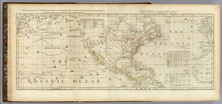
Chart containing the Coasts of California, New Albion, and Russian Discoveries to the North, with the Peninsula of Kamtschatka, in Asia, opposite thereto; And Islands, dispersed over the Pacific Ocean, to the North of the Line. North America and The West Indies, with the opposite Coasts of Europe and Africa. Published ... 10 June 1775, by R. Sayer & J. Bennett ... Fleet Street. IV.
List No
0346.002
Note
In outline color. Map has extensive notes and charts noting variations in latitudes and longitudes noted by different observations. Tracks of the ships in the Pacific Ocean shown along with relevant dates.
Author
Jefferys, Thomas
Full Title
(Composite of) A Chart of North and South America, including the Atlantic and Pacific Oceans ... (with) Chart containing the Coasts of California, New Albion, and Russian Discoveries to the North ... (with) Chart containing the greater part of the South Sea to the South of the Line ... Publish'd ... 10 June 1775, by Robt. Sayer & J. Bennett ... Fleet Street. No. II., IV., VI.
List No
0346.004
Note
Map has extensive notes and charts noting variations in latitudes and longitudes noted by different observations. Tracks of the ships in the oceans shown along with relevant dates. In outline color.
Author
[Faden, William, 1750?-1836, Jefferys, Thomas]
Full Title
Western Hemisphere. Engraved by Faden and Jefferys, Geographer to the King. London, publish'd according to Act of Parliament, 28th February 1775 by Jefferys and Faden, the Corner of St. Martin's Lane.
List No
2835.011
Note
Engraved map. Outline hand color. Relief shown pictorially.
Author
[Faden, William, 1750?-1836, Jefferys, Thomas]
Full Title
Western Hemisphere. London, publish'd by Jefferys & Faden, Corner of St. Martin's Lane, Charing Cross. (1775?)
List No
2835.012
Note
Engraved map. Blank outline map to be completed students; with title, imprint and grid lines only.
Author
[Green, John, d d. 1757, Jefferys, Thomas]
Full Title
(Covers to) A chart of North and South America including the Atlantic and Pacific Oceans, with the nearest coasts of Europe, Africa and Asia (by John Green]. Publish'd according to Act of Parliament Feb. 19, 1753, by T. Jefferys, Geographer to his Royal Highness the Prince of Wales at the Corner of St. Martins Lane Charing Cross ...
List No
4766A
Note
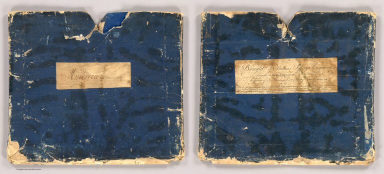
Original blue slipcase with label: Bought of Thomas Jefferys Engraver ... Enclosed in a new half cloth blue marbled paper book-like case 36x31 with "Green And Jefferys. Chart of North and South America. 1753." See our 13402.000 for the 48 pages of descriptive text that were issued with the map, here bound separately.
Author
[Green, John, d d. 1757, Jefferys, Thomas]
Full Title
A chart of North and South America including the Atlantic and Pacific Oceans, with the nearest coasts of Europe, Africa and Asia (by John Green]. Publish'd according to Act of Parliament Feb. 19, 1753, by T. Jefferys, Geographer to his Royal Highness the Prince of Wales at the Corner of St. Martins Lane Charing Cross ...
List No
4766.001
Note
The 1st ed. of this map, here published as a complete chart of six sheets joined, dissected into 16 sections and folded into Jeffery's original case with a printed label: "Bought of Thomas Jefferys Engraver..." Both map and case are preserved in a new half cloth blue marbled paper book-like case 36x31 with "Green And Jefferys. Chart of North and South America. 1753." stamped in gilt on a leather label on the spine. "This is one of the most important American maps of the period, the first to label Behring's Straits, and the most accurate of the time in establishing more correct placements of the coasts of North and South America and Northeastern Asia. The map is extensively annotated by Green to show the differences of latitude and longitude between his placements on the map and other cartographers, notably Bellin, D'Anville, Brouckner, Popple, and especially DeLisle and Buache in their claims of new discoveries on the American Northwest coast. Jefferys also published Green's "Remarks, In Support of the New Chart of North and South America, in six sheets" which further detail Green's attack on DeLisle's cartography and French claims to the American Northwest. The six sheets of this map are also found bound individually with the text, as in Streeter 3453. Our copy has a printed paste down label in the lower corner of sheet six that explains the color code used to distinguish the different claims of the British, French, etc. Stevens & Tree list several later issues of this chart, including those that appear in Jeffery's American Atlas of 1775. Outline color. See our 13402.000 for the 48 pages of descriptive text that were issued with the map, here bound separately.
1-6 of 6
|