|
REFINE
Browse All : Images by James Wyld of North America
1-16 of 16
Author
Wyld, James, 1812-1887
Full Title
(Covers to) Mexico The British Possessions In North America And The United States. London. Published By Jas. Wyld, Geographer To The Queen, Charing Cross East. 1846. James Wyld, Geographer to the Queen and to H.R.H. Prince Albert, Charing Cross, East, four doors from Trafalgar Square, London ... (inset) North America. (inset) Islands in the Pacific Ocean.
List No
2747.001
Note
Dissected in north and south sheets, each in 30 sections. This map is a reduction and reissue of Wyld's famous 1824 Map of North America (Stevens and Tree 63 - four editions from 1824 to 1856) - it does not have the top sheet showing the Arctic, it moves the title from the lower left to middle right (and changes title of course), and it updates some of the western geography, showing the Tule Lakes in California, Fremont's or South Pass, Fts Hall and Boise and the Oregon Trail. However, it keeps the outdated topography of the Great Basin and California used in the 1824 edition - the two large rivers running from the interior of the basin to the Pacific, and the mountain ranges running almost east to west instead of north to south in the basin. Nonetheless, it is a very beautiful map in the best of Wyld's cartographic style. Two insets in the lower right and left, of North America and Islands in the Pacific Ocean (both of which appear in the small General Atlas). Map comes from the family of Kit Carson's clerk. Has paste down catalogue. Wheat 658 (1849) is listed in our copy of Radford's Catalogue, 1975. Though smaller, it is likely derived from this map. With outline color. Sheets fold with marbled end sheets into original brown cloth slip case 25x15.5 with label reading "Canada Mexico &c. United States" (ms) and "James Wyld, Geographer To Her Majesty. Charing Cross, East ..."
Author
Wyld, James, 1812-1887
Full Title
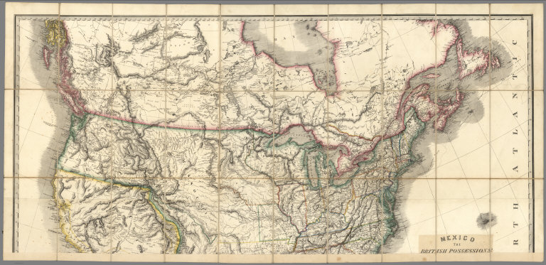
(North Sheet) Mexico The British Possessions In North America And The United States. London. Published By Jas. Wyld, Geographer To The Queen, Charing Cross East. 1846. James Wyld, Geographer to the Queen and to H.R.H. Prince Albert, Charing Cross, East, four doors from Trafalgar Square, London ... (inset) North America. (inset) Islands in the Pacific Ocean.
List No
2747.002
Note
Dissected in north and south sheets, each in 30 sections. This map is a reduction and reissue of Wyld's famous 1824 Map of North America (Stevens and Tree 63 - four editions from 1824 to 1856) - it does not have the top sheet showing the Arctic, it moves the title from the lower left to middle right (and changes title of course), and it updates some of the western geography, showing the Tule Lakes in California, Fremont's or South Pass, Fts Hall and Boise and the Oregon Trail. However, it keeps the outdated topography of the Great Basin and California used in the 1824 edition - the two large rivers running from the interior of the basin to the Pacific, and the mountain ranges running almost east to west instead of north to south in the basin. Nonetheless, it is a very beautiful map in the best of Wyld's cartographic style. Two insets in the lower right and left, of North America and Islands in the Pacific Ocean (both of which appear in the small General Atlas). Map comes from the family of Kit Carson's clerk. Has paste down catalogue. Wheat 658 (1849) is listed in our copy of Radford's Catalogue, 1975. Though smaller, it is likely derived from this map. With outline color. Sheets fold with marbled end sheets into original brown cloth slip case 25x15.5 with label reading "Canada Mexico &c. United States" (ms) and "James Wyld, Geographer To Her Majesty. Charing Cross, East ..."
Author
Wyld, James, 1812-1887
Full Title
(South Sheet) Mexico The British Possessions In North America And The United States. London. Published By Jas. Wyld, Geographer To The Queen, Charing Cross East. 1846. James Wyld, Geographer to the Queen and to H.R.H. Prince Albert, Charing Cross, East, four doors from Trafalgar Square, London ... (inset) North America. (inset) Islands in the Pacific Ocean.
List No
2747.003
Note
Dissected in north and south sheets, each in 30 sections. This map is a reduction and reissue of Wyld's famous 1824 Map of North America (Stevens and Tree 63 - four editions from 1824 to 1856) - it does not have the top sheet showing the Arctic, it moves the title from the lower left to middle right (and changes title of course), and it updates some of the western geography, showing the Tule Lakes in California, Fremont's or South Pass, Fts Hall and Boise and the Oregon Trail. However, it keeps the outdated topography of the Great Basin and California used in the 1824 edition - the two large rivers running from the interior of the basin to the Pacific, and the mountain ranges running almost east to west instead of north to south in the basin. Nonetheless, it is a very beautiful map in the best of Wyld's cartographic style. Two insets in the lower right and left, of North America and Islands in the Pacific Ocean (both of which appear in the small General Atlas). Map comes from the family of Kit Carson's clerk. Has paste down catalogue. Wheat 658 (1849) is listed in our copy of Radford's Catalogue, 1975. Though smaller, it is likely derived from this map. With outline color. Sheets fold with marbled end sheets into original brown cloth slip case 25x15.5 with label reading "Canada Mexico &c. United States" (ms) and "James Wyld, Geographer To Her Majesty. Charing Cross, East ..."
Author
Wyld, James, 1812-1887
Full Title
(Composite to) Mexico The British Possessions In North America And The United States. London. Published By Jas. Wyld, Geographer To The Queen, Charing Cross East. 1846. James Wyld, Geographer to the Queen and to H.R.H. Prince Albert, Charing Cross, East, four doors from Trafalgar Square, London ... (inset) North America. (inset) Islands in the Pacific Ocean.
List No
2747.004
Note
Composite of north and south sheets. Dissected in north and south sheets, each in 30 sections. This map is a reduction and reissue of Wyld's famous 1824 Map of North America (Stevens and Tree 63 - four editions from 1824 to 1856) - it does not have the top sheet showing the Arctic, it moves the title from the lower left to middle right (and changes title of course), and it updates some of the western geography, showing the Tule Lakes in California, Fremont's or South Pass, Fts Hall and Boise and the Oregon Trail. However, it keeps the outdated topography of the Great Basin and California used in the 1824 edition - the two large rivers running from the interior of the basin to the Pacific, and the mountain ranges running almost east to west instead of north to south in the basin. Nonetheless, it is a very beautiful map in the best of Wyld's cartographic style. Two insets in the lower right and left, of North America and Islands in the Pacific Ocean (both of which appear in the small General Atlas). Map comes from the family of Kit Carson's clerk. Has paste down catalogue. Wheat 658 (1849) is listed in our copy of Radford's Catalogue, 1975. Though smaller, it is likely derived from this map. With outline color. Sheets fold with marbled end sheets into original brown cloth slip case 25x15.5 with label reading "Canada Mexico &c. United States" (ms) and "James Wyld, Geographer To Her Majesty. Charing Cross, East ..."
Author
Wyld, James, 1812-1887
Full Title
(Covers to) Map of North America from 20 to 80 Degrees North Latitude Exhibiting The recent Discoveries, Geographical and Nautical; Drawn chiefly from the Authorities of M. De Humboldt, Lieutt. Pike, Messrs. Lewis and Clarke, Sir Alexr. MacKenzie, Mr. Hearne, Coll. Bouchette, Captns. Vancouver, Ross, Parry & Franklin, also describing the Boundary Lines between the Territories of Great Britain & Spain with the United States. London, Published by Jas. Wyld, (successor to W. Faden) No. 5, Charing Cross. Geographer to His Majesty; and to H.R.H. the Duke Of York. June 1st 1823.
List No
4087A
Author
Wyld, James, 1812-1887
Full Title
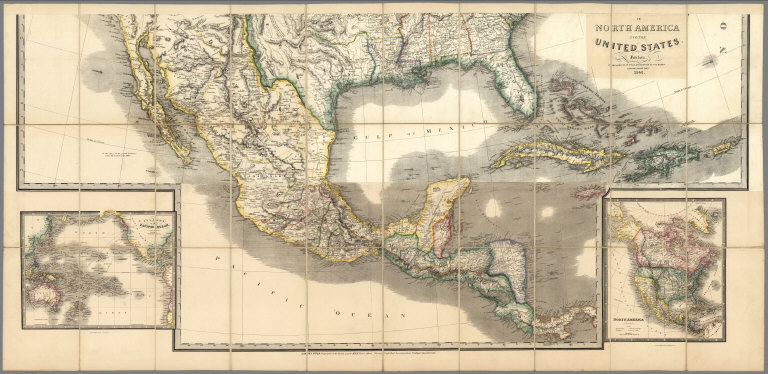
Map of North America from 20 to 80 Degrees North Latitude Exhibiting The recent Discoveries, Geographical and Nautical; Drawn chiefly from the Authorities of M. De Humboldt, Lieutt. Pike, Messrs. Lewis and Clarke, Sir Alexr. MacKenzie, Mr. Hearne, Coll. Bouchette, Captns. Vancouver, Ross, Parry & Franklin, also describing the Boundary Lines between the Territories of Great Britain & Spain with the United States. London, Published by Jas. Wyld, (successor to W. Faden) No. 5, Charing Cross. Geographer to His Majesty; and to H.R.H. the Duke Of York. June 1st 1823.
List No
4087.001
Note
The first edition, listed in Phillips but not by Stevens and Tree or Wheat (both list 1824/25 as the first edition). A large impressive map showing with great accuracy the recent discoveries in the north west passage, but wildly off in the American southwest - Wheat: "a large and beautiful map, excellent in all respects save for its southwestern geography." In the southwest, Wyld adds many mountain ranges that were purely speculative - probably just to fill in blank spaces in the map (unlike Arrowsmith). In northwestern Texas is a curious note on the topography of the area attributed to "Mellish" which is copied from a pre-1822 edition of his large map of the United States. Comparing this edition to the derived map of 1846, "Mexico, the British Possessions...," one sees many changes in the northern areas and few in the southwest. Stevens and Tree list editions of 1824, 1827/8, 1838, and 1851/56. The 1824/25 edition adds a fold out flap of Mexico and Central America (WH copy). With outline color. Map is dissected into 24 sections and mounted on linen. Map folds into a brown marbled paper covered slip case with black leather spine with "Map Of North America" stamped in gilt.
Author
[Wyld, James, 1812-1887, Wyld, James, 1790-1836]
Full Title
A map of North America. exhibiting the recent discoveries, Geographical and nautical. London. Published by James Wyld. J. W. del. Stockley sc. (to accompany) A new general atlas of modern geography : consisting of a complete collection of maps of the four quarters of the globe ...
List No
13170.054
Note
Engraved map, hand colored in outline. Covers polar region, Alaska, Canada, Iceland, Greenland, the West Indies and parts of Colombia. Shows boundaries, major cities and towns. Upper California includes the Rio Buenaventura and Rio Sacramento or Timpanagos, flowing from the Pacific to Lake Timpanagos (Salt Lake), and the mythical Lake Teguayo. Relief shown by hachures.
Author
[Wyld, James, 1812-1887, Wyld, James, 1790-1836]
Full Title
A map of the Province of Upper Canada : describing all the new settlements, townships & c. With the countries adjacent. From Quebec to Lake Huron. Compiled from the original documents in the Surveyor General's Office. London. Published by Jas. Wyld. 1838. (to accompany) A new general atlas of modern geography : consisting of a complete collection of maps of the four quarters of the globe ...
List No
13170.055
Note
Folded map, hand colored in outline. Shows district, county and township boundaries, rivers, canals, Native American settlements, and major roads. Relief shown by hachures. Prime meridian is Greenwich.
Author
[Wyld, James, 1812-1887, Wyld, James, 1790-1836]
Full Title
A new map of the province of Lower Canada : describing all the seigneuries, townships, grants of land, &c. Compiled from plans deposited in the Patent Office, Quebec : by Samuel Holland, Esq. Surveyor General ... London. Published by James Wyld. 1838. (to accompany) A new general atlas of modern geography : consisting of a complete collection of maps of the four quarters of the globe ...
List No
13170.056
Note
Folded map, hand colored in outline. Shows district, county and township boundaries, rivers, canals and major roads. Relief shown by hachures. Depth shown by soundings. Prime meridian is Greenwich.
Author
[Wyld, James, 1812-1887, Wyld, James, 1790-1836]
Full Title
The United States of North America, with the British Territories. London. Published by Jas. Wyld. 1838. (to accompany) A new general atlas of modern geography : consisting of a complete collection of maps of the four quarters of the globe ...
List No
13170.057
Note
Double page engraved map, hand colored in outline. Covers Eastern United States, part of Canada. Shows district, county and township boundaries, rivers, canals and major roads. Shows DeVallieres Grant, above the White River and Cherokee Settlement in Western Arkansas on what would become the Oklahoma Border. This is the only time we have ever seen this Grant on a map. Relief shown pictorially.
Author
Wyld, James, 1812-1887
Full Title
North America. J.W. del. (engraved by) Stockley, Sc. London, James Wyld, Charing Cross. (to accompany) An Atlas of the World, Comprehending Separate Maps of its various Countries, Constructed & drawn from the latest Astronomical & Geographical Observations. By James Wyld, Geographer to Her Majesty and H. Late R.H. Prince Albert. London. Published by James Wyld (Successor to Mr. Faden) Charing Cross East. 1864.
List No
2225.043
Note
Outline hand colored boundaries. Plate 43 corrected to 45. Includes area and population. Showing list of the countries in Central America. "Atlas of the World" printed on the upper right corner. A late edition of this atlas, published as early as 1836 (see our copy). Several new maps of Australia and South Africa are added and the other maps have been updated to show railroad development. The American maps have been updated, but inadequately so in the West - the River Buenaventura is still flowing out of Salt Lake on the Mexico Map. Half leather cloth-covered boards with stamped title "Wyld's General Atlas" on cover in gold. Relief shown by hachures. Prime meridian is Greenwich.
Author
Wyld, James, 1812-1887
Full Title
Map of the British Possessions in North America. J.W. del. (engraved by) Stockley, Sc. London, James Wyld, Charing Cross. (to accompany) An Atlas of the World, Comprehending Separate Maps of its various Countries, Constructed & drawn from the latest Astronomical & Geographical Observations. By James Wyld, Geographer to Her Majesty and H. Late R.H. Prince Albert. London. Published by James Wyld (Successor to Mr. Faden) Charing Cross East. 1864.
List No
2225.044
Note
Outline hand colored boundaries. Plate 44 corrected to 46. Including Canada, New Brunswick and Nova Scotia. Showing railways, and the statistical table includes area and population. "Atlas of the World" printed on the upper right corner. A late edition of this atlas, published as early as 1836 (see our copy). Several new maps of Australia and South Africa are added and the other maps have been updated to show railroad development. The American maps have been updated, but inadequately so in the West - the River Buenaventura is still flowing out of Salt Lake on the Mexico Map. Half leather cloth-covered boards with stamped title "Wyld's General Atlas" on cover in gold. Relief shown by hachures. Prime meridian is Greenwich.
Author
Wyld, James, 1812-1887
Full Title
Map of the United States of North America. J.W. del. (engraved by) Stockley, Sc. London, James Wyld, Charing Cross. (to accompany) An Atlas of the World, Comprehending Separate Maps of its various Countries, Constructed & drawn from the latest Astronomical & Geographical Observations. By James Wyld, Geographer to Her Majesty and H. Late R.H. Prince Albert. London. Published by James Wyld (Successor to Mr. Faden) Charing Cross East. 1864.
List No
2225.045
Note
Outline hand colored boundaries by the states. Plate 45 corrected to 47. Statistical table includes area and population. Showing railways and canals. "Atlas of the World" printed on the upper right corner. A late edition of this atlas, published as early as 1836 (see our copy). Several new maps of Australia and South Africa are added and the other maps have been updated to show railroad development. The American maps have been updated, but inadequately so in the West - the River Buenaventura is still flowing out of Salt Lake on the Mexico Map. Half leather cloth-covered boards with stamped title "Wyld's General Atlas" on cover in gold. Relief shown by hachures. Prime meridian is Greenwich.
Author
Wyld, James, 1812-1887
Full Title
Republic of Mexico and Texas. J.W. del. (engraved by) Stockley, Sc. London, James Wyld, Charing Cross. (to accompany) An Atlas of the World, Comprehending Separate Maps of its various Countries, Constructed & drawn from the latest Astronomical & Geographical Observations. By James Wyld, Geographer to Her Majesty and H. Late R.H. Prince Albert. London. Published by James Wyld (Successor to Mr. Faden) Charing Cross East. 1864.
List No
2225.046
Note
Outline hand colored boundaries. Statistical table includes area, population, and extent in sq. miles. Includes text. "Atlas of the World" printed on the upper right corner. A late edition of this atlas, published as early as 1836 (see our copy). Several new maps of Australia and South Africa are added and the other maps have been updated to show railroad development. The American maps have been updated, but inadequately so in the West - the River Buenaventura is still flowing out of Salt Lake on the Mexico Map. Half leather cloth-covered boards with stamped title "Wyld's General Atlas" on cover in gold. Relief shown by hachures. Prime meridian is Greenwich.
Author
Wyld, James, 1812-1887
Full Title
(Covers to) Map of North America Exhibiting The recent Discoveries, Geographical and Nautical; Drawn chiefly from the Authorities of Hudson Bay Company's Officers, The Government Arctic Expeditions, and the Surveys Of The United States & Dominion Governments. also describing the Boundary Lines between the Territories of Great Britain The United States and the Mexican And Central States. London. Published by Ja. Wyld, Geographer to the Queen, 11&12 Charing Cross London, S.W. Geographer to Her Majesty.
List No
5474A
Note
Date is estimated based on extent of railroad construction. Case map in seven sections. Each section in 10 pieces mounted on linen. Outline color throughout. Central American map section titled "Mexico and Guatemala, shewing the Position of the Mines." Each section labeled with position (i.e. S.W., S.E.) and enclosed in a brown leather covered slip case 27x19 with sticker from "James Wyld Geographer To Her Majesty" noting shop location.
Author
Wyld, James, 1812-1887
Full Title
Map of North America Exhibiting The recent Discoveries, Geographical and Nautical; Drawn chiefly from the Authorities of Hudson Bay Company's Officers, The Government Arctic Expeditions, and the Surveys Of The United States & Dominion Governments. also describing the Boundary Lines between the Territories of Great Britain The United States and the Mexican And Central States. London. Published by Ja. Wyld, Geographer to the Queen, 11&12 Charing Cross London, S.W. Geographer to Her Majesty.
List No
5474.001
Note
Date is estimated based on extent of railroad construction. Case map in seven sections. Each section in 10 pieces mounted on linen. Outline color throughout. Central American map section titled "Mexico and Guatemala, shewing the Position of the Mines." Each section labeled with position (i.e. S.W., S.E.) and enclosed in a brown leather covered slip case 27x19 with sticker from "James Wyld Geographer To Her Majesty" noting shop location.
1-16 of 16
|