|
REFINE
Browse All : Images by J. & G. Menzies and John Cumming
1-30 of 30
Author
[Buchanan, George, Thomson, John]
Full Title
Northern Hemisphere projected on the plane of the horizon of London. By Geo. Buchanan. J. & G. Menzies sculpt., Edinr. Projected & engraved for Thomson's New general atlas, 20th Sept. 1816.
List No
1007.007
Note
Engraved map. Outline hand color. Relief shown by hachures. "N.B. The scale is quite correct for distances from London; it is also very nearly so for distances on any part of the meridian of London or on any lines passing through London."
Author
[Buchanan, George, Thomson, John]
Full Title
Southern Hemisphere projected on the plane of the horizon of London. By Geo. Buchanan. J. & G. Menzies sculpt., Edinr. Projected & engraved for Thomson's New general atlas, 20th Sept. 1816.
List No
1007.008
Note
Engraved map. Outline hand color. Relief shown by hachures. "N.B. The scale only measures with sufficient accuracy distances in the direction of the meridians."
Author
Thomson, John
Full Title
Europe. J. & G. Menzies sculpt. (1817)
List No
1007.009
Note
Engraved map. Hand color. Relief shown pictorially.
Author
Thomson, John
Full Title
The British Channel. J. & G. Menzies sculpt., Edinr. Drawn & engraved for Thomson's New general atlas, 16th Sept. 1814.
List No
1007.015
Note
Engraved map. Hand colored.
Author
Thomson, John
Full Title
Scandinavia, or Sweden, Denmark & Norway. J. & G. Menzies sculpt., Edinbr. (Drawn & engraved for Thomson's New general atlas, 1817)
List No
1007.017
Note
Engraved map. Hand colored.
Author
Thomson, John
Full Title
Spain & Portugal. J. & G. Menzies sculpt., Edinr. Drawn & engraved for Thomson's New general atlas, 21st Augt. 1815.
List No
1007.024
Note
Engraved map. Hand colored. Relief shown by hachures.
Author
Thomson, John
Full Title
Poland as divided. J. & G. Menzies sculpt, Edinr. (Drawn & engraved for Thomson's New general atlas, 1817)
List No
1007.033
Note
Engraved map. Hand colored. Relief shown by hachures.
Author
Thomson, John
Full Title
Asia. J. & G. Menzies sculpt. (Drawn & engraved for Thomson's New general atlas, 1817)
List No
1007.038
Note
Engraved map. Hand colored. Relief shown pictorially.
Author
Thomson, John
Full Title
Corea and Japan. J. & G. Menzies sculpt., Edinr. Drawn & engraved for Thomson's New general atlas, 16th. Augt. 1815.
List No
1007.041
Note
Engraved map. Hand colored. Relief shown by hachures.
Author
[J. & G. Menzies, Thomson, John]
Full Title
Hindoostan. (with) Isle of Ceylon. J. & G. Menzies sculpt., Edinr. (Drawn & engraved for Thomson's New general atlas, 1817)
List No
1007.044
Note
Engraved map with inset. Hand colored. Relief shown by hachures.
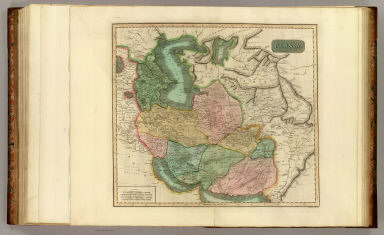
Author
Thomson, John
Full Title
Persia. J. & G. Menzies sculpt., Edinr. (Drawn & engraved for Thomson's New general atlas, 1817)
List No
1007.048
Note
Engraved map. Hand colored. Relief shown by hachures.
Author
Thomson, John
Full Title
Arabia, Egypt, Abyssinia, Red Sea &c. J. & G. Menzies sculpt., Edinr. Drawn and engraved for Thomson's New general atlas, 14th July 1814.
List No
1007.050
Note
Engraved map. Outline hand color. Relief shown by hachures. Includes descriptive notes.
Author
[J. & G. Menzies, Thomson, John]
Full Title
Africa. J. & G. Menzies sculpt. (Drawn & engraved for Thomson's New general atlas, 1813?)
List No
1007.052
Note
Engraved map. Hand colored. Relief shown pictorially. Printed label with "No. 47" pasted on verso.
Author
Thomson, John
Full Title
America. J. & G. Menzies sculpt. Drawn and engraved for Thomson's New general atlas, 1st July, 1813.
List No
1007.057
Note
Engraved map. Hand colored. Relief shown pictorially.
Author
Thomson, John
Full Title
United States of America. (with) The course of the River St. Laurence, from Lake Ontario to Manicouagan Point. J. & G. Menzies sculpt., Edinr. (Drawn & engraved for Thomson's New general atlas, 1817)
List No
1007.061
Note
Engraved map with ancillary map. Hand colored. Relief shown by hachures.
Author
Thomson, John
Full Title
Porto Rico and Virgin Isles. Haiti, Hispaniola or St. Domingo. West India Islands. J. & G. Menzies sculpt., Edinr. Drawn and engraved for Thomson's New general atlas, Feby. 1815.
List No
1007.069
Note
Two engraved maps on 1 sheet. Hand colored. Relief shown by hachures. Scale of Hispaniola map ca. 1:1,150,000.
Author
[Johnson, William, fl. 1806-1840, Thomson, John]
Full Title
County of Wigton or Shire of Galloway. From Ainslie's survey by W. Johnson, Landsurveyor. Drawn by W. Johnson, Edinr. Engd. by J. & G. Menzies, Edinr. Published by John Thomson, Edinburgh, 1826. (1832)
List No
5748.027
Note
Hand colored engraved map. Relief shown by hachures. Shows settlements, roads, etc. David Rumsey Collection copy imperfect: part of imprint missing.
Author
Thomson, John
Full Title
Northern part of Argyllshire. Drawn by W. Johnson, Edinr. Engd. by J. & G. Menzies, Edinr. Published by John Thomson & Co., Edinburgh, 1824. (1832)
List No
5748.044
Note
Hand colored engraved map. Relief shown by hachures. Shows settlements, roads, etc. Includes inset map of Coll and Tirree islands. David Rumsey Collection copy: imprint cropped.
Author
Thomson, John
Full Title
Southern part of Argyllshire. (with) Campbeltown. Drawn by W. Johnson, Edinr. Engd. by J. & G. Menzies, Edinr. Published by John Thomson & Co., Edinburgh, 1824. (1832)
List No
5748.045
Note
Hand colored engraved map. Relief shown by hachures. Shows settlements, roads, etc. Includes inset map of part of Cantire.
Author
Thomson, John
Full Title
(Composite of) Northern part ... Southern part of Argyllshire. (with) Campbeltown. Drawn by W. Johnson, Edinr. Engd. by J. & G. Menzies, Edinr. Published by John Thomson & Co., Edinburgh, 1824. (1832)
List No
5748.046
Note
Digital composite of 2 hand colored engraved maps. Relief shown by hachures. Shows settlements, roads, etc. Includes inset maps of Coll and Tirree islands and part of Cantire.
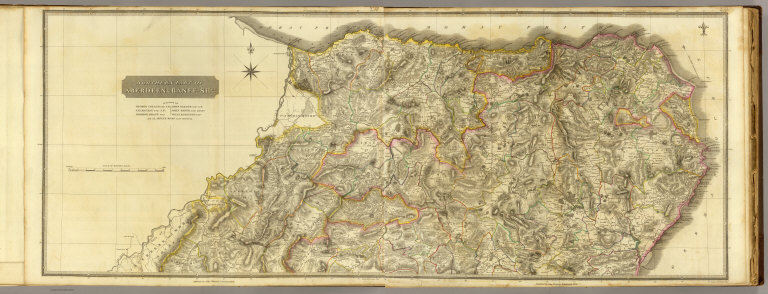
Author
Thomson, John
Full Title
Northern part of Aberdeen & Banff-Shrs. Eng. by J. & G. Menzies, Edinr. Published by John Thomson, Edinburgh, 1826. (1832)
List No
5748.059
Note
Hand colored engraved map (western sheet). Relief shown by hachures. Shows settlements, roads, etc.
Author
Thomson, John
Full Title
(Northern part of Aberdeen & Banff-Shrs.) Eng. by J. & G. Menzies, Edinr. Published by John Thomson, Edinburgh, 1826. (1832)
List No
5748.060
Note
Hand colored engraved map (eastern sheet). Relief shown by hachures. Shows settlements, roads, etc.
Author
Thomson, John
Full Title
(Composite of) Northern part of Aberdeen & Banff-Shrs. Eng. by J. & G. Menzies, Edinr. Published by John Thomson, Edinburgh, 1826. (1832)
List No
5748.061
Note
Digital composite of hand colored engraved map on 2 sheets. Relief shown by hachures. Shows settlements, roads, etc.
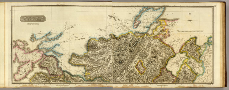
Author
[Johnson, William, fl. 1806-1840, Thomson, John]
Full Title
Northern part of Inverness Shire. Compiled by William Johnson, Land Surveyor, Edinburgh. (Engraved by) J. & G. Menzies, Edinr. Published by John Thomson & Co., Edinburgh, 1830. (1832)
List No
5748.070
Note
Hand colored engraved map (western half). Relief shown by hachures. Shows settlements, roads, etc.
Author
Thomson, John
Full Title
(Northern part of Inverness Shire. Compiled by William Johnson, Land Surveyor, Edinburgh. Engraved by) J. & G. Menzies, Edinr. Published by John Thomson & Co., Edinburgh, 1830. (1832)
List No
5748.071
Note
Hand colored engraved map (eastern half). Relief shown by hachures. Shows settlements, roads, etc.
Author
[Johnson, William, fl. 1806-1840, Thomson, John]
Full Title
(Composite of) Northern part of Inverness Shire. Compiled by William Johnson, Land Surveyor, Edinburgh. (Engraved by) J. & G. Menzies, Edinr. Published by John Thomson & Co., Edinburgh, 1830. (1832)
List No
5748.072
Note
Digital composite of hand colored engraved map on 2 sheets. Relief shown by hachures. Shows settlements, roads, etc.
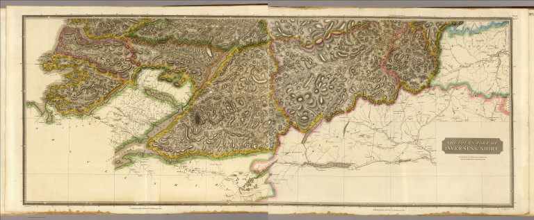
Author
Thomson, John
Full Title
(Southern part of Inverness Shire. Compiled by William Johnson, Land Surveyor, Edinburgh. Engraved by) J. & G. Menzies, Edinr. Published by John Thomson & Co., Edinburgh, 1830. (1832)
List No
5748.073
Note
Hand colored engraved map (western half). Relief shown by hachures. Shows settlements, roads, etc.
Author
[Johnson, William, fl. 1806-1840, Thomson, John]
Full Title
Southern part of Inverness Shire. Compiled by William Johnson, Land Surveyor, Edinburgh. (Engraved by) J. & G. Menzies, Edinr. Published by John Thomson & Co., Edinburgh, 1830. (1832)
List No
5748.074
Note
Hand colored engraved map (eastern half). Relief shown by hachures. Shows settlements, roads, etc.
Author
[Johnson, William, fl. 1806-1840, Thomson, John]
Full Title
(Composite of) Southern part of Inverness Shire. Compiled by William Johnson, Land Surveyor, Edinburgh. (Engraved by) J. & G. Menzies, Edinr. Published by John Thomson & Co., Edinburgh, 1830. (1832)
List No
5748.075
Note
Digital composite of hand colored engraved map on 2 sheets. Relief shown by hachures. Shows settlements, roads, etc.
Author
[Johnson, William, fl. 1806-1840, Thomson, John]
Full Title
(Composite of) Inverness Shire. Compiled by William Johnson, Land Surveyor, Edinburgh. (Engraved by) J. & G. Menzies, Edinr. Published by John Thomson & Co., Edinburgh, 1830. (1832)
List No
5748.076
Note
Digital composite of hand colored engraved map on 4 sheets. Relief shown by hachures. Shows settlements, roads, etc.
1-30 of 30
|