|
Author
Chesney, Francis Rawson (1789 - 1872)
Full Title
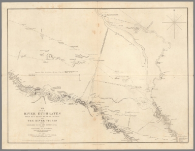
I. The River Euphrates with the Cilician Taurus and Northern Syria.
List No
15662.001
Author
Chesney, Francis Rawson (1789 - 1872)
Full Title
II. The River Euphrates from Sumeisat to Kal’at En Nejm.
List No
15662.002
Author
Chesney, Francis Rawson (1789 - 1872)
Full Title
III. The River Euphrates from Kal’at En Nejm to Abu Saide.
List No
15662.003
Author
Chesney, Francis Rawson (1789 - 1872)
Full Title
IV. The River Euphrates from Abu Saide to Werdi.
List No
15662.004
Author
Chesney, Francis Rawson (1789 - 1872)
Full Title
V. The River Euphrates from Werdi to Hit.
List No
15662.005
Author
Chesney, Francis Rawson (1789 - 1872)
Full Title
VI. The River Tigris from Nineveh to Kal’ah Sherkat, and again from Kal’ah Sherkat to Sammarra.
List No
15662.006
Author
Chesney, Francis Rawson (1789 - 1872)
Full Title
VII. The River Euphrates from Hit to the Kuthah River, and River Tigris from Sammarra to the Abu Hitti Canal.
List No
15662.007
Author
Chesney, Francis Rawson (1789 - 1872)
Full Title
VIII. The River Euphrates from the Kuthah River to El Wuja Island, and the River Tigris from the Abu Hitti Canal to Judifah Island.
List No
15662.008
Author
Chesney, Francis Rawson (1789 - 1872)
Full Title
IX. The River Euphrates from El Wuja Island to Ummu-l-Huntah, and the RiverTigris from Judifah Island to Serut Castle.
List No
15662.009
Author
Chesney, Francis Rawson (1789 - 1872)
Full Title
X. The River Euphrates from Ummu-l-Huntah to Kurnali, and the River Tigris from Serut Castle to Kurnah.
List No
15662.010
Author
Chesney, Francis Rawson (1789 - 1872)
Full Title
XI. The River Karun from Shuster to Salmanah Island.
List No
15662.011
Author
Chesney, Francis Rawson (1789 - 1872)
Full Title
XII. The Shatt el’Arab from Basrah to the Bar of the Euphrates, and the River Karun from Salmanah Island to Mohammerah, with the Bah-a-Mishi'r.
List No
15662.012
Author
Society for the Diffusion of Useful Knowledge (Great Britain)
Full Title
Geological Map of England and Wales.
List No
10911.012
Author
Society for the Diffusion of Useful Knowledge (Great Britain)
Full Title
The Turkish Empire in Europe and Asia with the Kingdom of Greece.
List No
10911.050
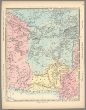
Author
Society for the Diffusion of Useful Knowledge (Great Britain)
Full Title
Arabia with Egypt, Nubia, and Abyssinia.
List No
10911.054
Author
Society for the Diffusion of Useful Knowledge (Great Britain)
Full Title
Persia with Part of the Ottoman Empire.
List No
10911.055
Author
Society for the Diffusion of Useful Knowledge (Great Britain)
Full Title
Bokhara, Afghanistan, Beloochistan, &c.
List No
10911.056
Author
Society for the Diffusion of Useful Knowledge (Great Britain)
Full Title
China, the Interior Chiefly from the Jesuits 1710 to 1718, and the Sea Coast from Modern Authorities.
List No
10911.060
Author
Society for the Diffusion of Useful Knowledge (Great Britain)
Full Title
Empire of Japan, Yedo ... Meaco. (insets) Nagasaki Harbour. Eastern Point of Yeso.
List No
10911.063
Author
Society for the Diffusion of Useful Knowledge (Great Britain)
Full Title
Africa.
List No
10911.064
Author
Society for the Diffusion of Useful Knowledge (Great Britain)
Full Title
The United States of North America.
List No
10911.075
Author
Society for the Diffusion of Useful Knowledge (Great Britain)
Full Title
The Australian Colonies. (insets) The World ... with Distances from Australian Ports. Tasmania.
List No
10911.080
Note
Fold-out map.
Author
Society for the Diffusion of Useful Knowledge (Great Britain)
Full Title
London.
List No
10911.093
Author
Society for the Diffusion of Useful Knowledge (Great Britain)
Full Title
Western Hemisphere. Eastern Hemisphere. Published by and under the superintendence of the Society for the Diffusion of Useful Knowledge, 59 Lincoln's Inn Fields. Engraved by J. & C. Walker. (London: Chapman and Hall, 1844)
List No
0890.001
Note
Two engraved, circular maps. Country boundaries hand col. Relief shown by hachures. Includes tables of animals, highest mountains, surface of the globe, population and religions.
Author
Society for the Diffusion of Useful Knowledge (Great Britain)
Full Title
The world on Mercator's projection. Published by and under the superintendence of the Society for the Diffusion of Useful Knowledge, 59 Lincoln's Inn Fields, 15th. March 1841. J. & C. Walker sculpt. (London: Chapman and Hall, 1844)
List No
0890.002
Note
Engraved map on 2 sheets. Country boundaries hand col. Relief shown by hachures.
Author
[Smith, Philip, 1817-1885, Society for the Diffusion of Useful Knowledge (Great Britain)]
Full Title
The world as known to the ancients. (Published by and under the superintendence of the Society for the Diffusion of Useful Knowledge, 59 Lincoln's Inn Fields). J. & C. Walker sculpt. Drawn by Revd. Philip Smith. Published by Chapman and Hall, 1842.
List No
0890.003
Note
Engraved map on 2 sheets. Continental boundaries hand col. Relief shown by hachures. Includes geographic notes.
Author
Society for the Diffusion of Useful Knowledge (Great Britain)
Full Title
(World on gnomonic projection. I. Africa and south Europe). No.1. Published by Baldwin & Cradock, 47 Paternoster Row June 1831. Under the superintendence of the Society for the Diffusion of Useful Knowledge. Engraved by J. & C. Walker.
List No
0890.004
Note
Engraved map. No. 1 of 6 sheets. Country boundaries hand col. Relief shown by hachures. Shows tidal information including cotidal isolines. Issued earlier and separately. Title from contents page.
Author
Society for the Diffusion of Useful Knowledge (Great Britain)
Full Title
(World on gnomonic projection. II. America). No.2. Published by Baldwin & Cradock, 47 Paternoster Row June 1831. Under the superintendence of the Society for the Diffusion of Useful Knowledge. Engraved by J. & C. Walker.
List No
0890.005
Note
Engraved map. No. 2 of 6 sheets. Country boundaries hand col. Relief shown by hachures. Shows tidal information including cotidal isolines. Issued earlier and separately. Title from contents page.
Author
Society for the Diffusion of Useful Knowledge (Great Britain)
Full Title
(World on gnomonic projection. III. Polynesia) . No.3. Published by Baldwin & Cradock, 47 Paternoster Row June 1831. Under the superintendence of the Society for the Diffusion of Useful Knowledge. Engraved by J. & C. Walker.
List No
0890.006
Note
Engraved map. No. 3 of 6 sheets. Country boundaries hand col. Shows tidal information including cotidal isolines. Issued earlier and separately. Title from contents page.
Author
Society for the Diffusion of Useful Knowledge (Great Britain)
Full Title
(World on gnomonic projection. IV. Asia). No.4. Published by Baldwin & Cradock, 47 Paternoster Row June 1831. Under the superintendence of the Society for the Diffusion of Useful Knowledge. Engraved by J. & C. Walker.
List No
0890.007
Note
Engraved map. No. 4 of 6 sheets. Country boundaries hand col. Relief shown by hachures. Shows tidal information including cotidal isolines. Issued earlier and separately. Title from contents page.
Author
Society for the Diffusion of Useful Knowledge (Great Britain)
Full Title
(World on gnomonic projection. V. From North Pole (to) 450 N. Lat.). No.5. Published by Baldwin & Cradock, 47 Paternoster Row June 1831. Under the superintendence of the Society for the Diffusion of Useful Knowledge. Engraved by J. & C. Walker.
List No
0890.008
Note
Engraved map. No. 5 of 6 sheets. Country boundaries hand col. Relief shown by hachures. Shows tidal information including cotidal isolines. Issued earlier and separately. Title from contents page.
Author
Society for the Diffusion of Useful Knowledge (Great Britain)
Full Title
(World on gnomonic projection. VI. From South Pole to 450 S. Lat.). No.6. Published by Baldwin & Cradock, 47 Paternoster Row June 1831. Under the superintendence of the Society for the Diffusion of Useful Knowledge. Engraved by J. & C. Walker.
List No
0890.009
Note
Engraved map. No. 6 of 6 sheets. Country boundaries hand col. Relief shown by hachures. Shows tidal information including cotidal isolines. Issued earlier and separately. Title from contents page.
Author
Society for the Diffusion of Useful Knowledge (Great Britain)
Full Title
Europe. Published under the superintendence of the Society for the Diffusion of Useful Knowledge. Published by Baldwin & Cradock, 47 Paternoser Row Feby. 1st. 1836. J. & C. Walker sculpt. Printed by Russell, Penge, Surrey. (London: Chapman and Hall, 1844)
List No
0890.010
Note
Engraved map. Country boundaries hand col. Relief shown by hachures. Includes table of countries with population and population per square mile.
Author
Society for the Diffusion of Useful Knowledge (Great Britain)
Full Title
The British Isles. Published under the superintendence of the Society for the Diffusion of Useful Knowledge, 59 Lincolns Inn Fields, April 1842, by Chapman & Hall 186 Strand. J. & C. Walker sculpt. (1844)
List No
0890.011
Note
Engraved map. County boundaries hand col. Relief shown by hachures.
Author
[Murchison, Roderick Impey, Sir, 1792-1871, Society for the Diffusion of Useful Knowledge (Great Britain)]
Full Title
Geological map of England and Wales. Published under the superintendence of the Society for the Diffusion of Useful Knowledge. 1843. Arranged by Roderick Impey Murchison ... S.P. Woodward del. Col(oure)d. by T. Malby. J. & C. Walker sculpt. Published by Chapman & Hall 186 Strand Decr. 15th. 1843. (1844)
List No
0890.012
Note
Engraved map. Geologic units hand col. Also shows railroads, canals, navigable rivers and dip of strata.
Author
Society for the Diffusion of Useful Knowledge (Great Britain)
Full Title
England with its canals and railways. Published under the superintendence of the Society for the Diffusion of Useful Knowledge. London, published by Baldwin & Cradock, 47 Paternoster Row Octr. 1st. 1837. Engd. by J. & C. Walker. (London: Chapman and Hall, 1844)
List No
0890.013
Note
Engraved map. Canals, railroads and county boundaries hand col.
Author
Society for the Diffusion of Useful Knowledge (Great Britain)
Full Title
England I. Published under the superintendence of the Society for the Diffusion of Useful Knowledge. Published February 1, 1831 by Baldwin & Cradock, Paternoster Row, London. J. & C. Walker, sculpt. (London: Chapman and Hall, 1844)
List No
0890.014
Note
Engraved map. County boundaries hand col. Relief shown by hachures and and spot heights. Shows canals, railways, etc. Inset: Isle of Map. Covers northern England.
Author
Society for the Diffusion of Useful Knowledge (Great Britain)
Full Title
England II. Published under the superintendence of the Society for the Diffusion of Useful Knowledge. Published by Baldwin & Cradock, 47 Paternoster Row, April 1st. 1831. J. & C. Walker, sculpt. (London: Chapman and Hall, 1844)
List No
0890.015
Note
Engraved map. County boundaries hand col. Relief shown by hachures and and spot heights. Shows canals, railways, etc. Covers Wales and part of central England.
Author
Society for the Diffusion of Useful Knowledge (Great Britain)
Full Title
England III. Published under the superintendence of the Society for the Diffusion of Useful Knowledge. Published by Baldwin & Cradock, 47 Paternoster Row, Sepr. 1st. 1830. J. & C. Walker, sculpt. (London: Chapman and Hall, 1844)
List No
0890.016
Note
Engraved map. County boundaries hand col. Relief shown by hachures and and spot heights. Shows canals, railways, etc. Covers Eastern England.
Author
Society for the Diffusion of Useful Knowledge (Great Britain)
Full Title
England IV. Published under the superintendence of the Society for the Diffusion of Useful Knowledge. Published by Baldwin & Cradock, 47 Paternoster Row, June 15th. 1830. J. & C. Walker, sculpt. (London: Chapman and Hall, 1844)
List No
0890.017
Note
Engraved map. County boundaries hand col. Relief shown by hachures and and spot heights. Shows canals, railways, etc. Includes inset of the Scilly Isles. Covers southwestern England.
Author
Society for the Diffusion of Useful Knowledge (Great Britain)
Full Title
England V. Published under the superintendence of the Society for the Diffusion of Useful Knowledge. Published by Baldwin & Cradock, 47 Paternoster Row, June 15th. 1830. J. & C. Walker, sculpt. (London: Chapman and Hall, 1844)
List No
0890.018
Note
Engraved map. County boundaries hand col. Relief shown by hachures and and spot heights. Shows canals, railways, etc. Covers southeastern England.
Author
Society for the Diffusion of Useful Knowledge (Great Britain)
Full Title
Scotland. Published by and under the superintendence of the Society for the Diffusion of Useful Knowledge, 59 Lincoln's Inn Fields, Novr. 29th. 1841. J. & C. Walker, sculpt. (London: Chapman and Hall, 1844)
List No
0890.019
Note
Engraved map. County boundaries hand col. Relief shown by hachures. Rumsey Collection copy has small portion missing at bottom.
Author
Society for the Diffusion of Useful Knowledge (Great Britain)
Full Title
Scotland I. Published under the superintendence of the Society for the Diffusion of Useful Knowledge. Engraved by J. & C. Walker. London, published by Baldwin & Cradock, 47 Paternoster Row, March 1st, 1834. (London: Chapman and Hall, 1844)
List No
0890.020
Note
Engraved map. County boundaries hand col. Relief shown by hachures and spot heights. "Adapted to the points of the Trigonometrical Survey." Includes table of former names by which the principal divisions of the country where known. Covers southern Scotland.
Author
Society for the Diffusion of Useful Knowledge (Great Britain)
Full Title
Scotland II. Published under the superintendence of the Society for the Diffusion of Useful Knowledge. Engraved by J. & C. Walker. London, published by Baldwin & Cradock, 47 Paternoster Row, March 1st, 1834. (London: Chapman and Hall, 1844)
List No
0890.021
Note
Engraved map. County boundaries hand col. Relief shown by hachures and spot heights. "Adapted to the points of the Trigonometrical Survey." Includes table of former names by which the principal divisions of the country where known. Covers northern Scotland.
Author
Society for the Diffusion of Useful Knowledge (Great Britain)
Full Title
Scotland III. Published under the superintendence of the Society for the Diffusion of Useful Knowledge. J. & C. Walker sculpt. Published by Baldwin & Cradock, 47 Paternoster Row, June 1st, 1834. (London: Chapman and Hall, 1844)
List No
0890.022
Note
Engraved map in 2 segments. County boundaries hand col. Relief shown by hachures and spot heights. Covers the Hebrides, Orkneys and Shetlands. Includes 3 insets.
Author
Society for the Diffusion of Useful Knowledge (Great Britain)
Full Title
Ancient Britain I. Published under the superintendence of the Society for the Diffusion of Useful Knowledge. J. & C. Walker sculp. London, Published by Baldwin & Cradock, 47 Paternoster Row, Octr. 1st , 1834. (London: Chapman and Hall, 1844)
List No
0890.023
Note
Engraved map. Division boundaries hand col. Relief shown by hachures. Includes notes on administrative divisions, places, roads, etc. Covers England and Wales.
Author
Society for the Diffusion of Useful Knowledge (Great Britain)
Full Title
Ancient Britain II. Published under the superintendence of the Society for the Diffusion of Useful Knowledge. J. & C. Walker sculp. London, Published by Baldwin & Cradock, 47 Paternoster Row, Octr. 1st , 1834. (London: Chapman and Hall, 1844)
List No
0890.024
Note
Engraved map. Division boundaries hand col. Relief shown by hachures. Includes notes on administrative divisions, places, roads, etc. Covers Scotland.
Author
Society for the Diffusion of Useful Knowledge (Great Britain)
Full Title
Ireland. Published by the Society for the Diffusion of Useful Knowledge, 59 Lincoln's Inn Fields Jany. 15th. 1842. Engraved by J. & C. Walker. (London: Chapman and Hall, 1844)
List No
0890.025
Note
Engraved map. Division boundaries hand col. Relief shown by hachures. Includes table of populations from 1831 census.
Author
Society for the Diffusion of Useful Knowledge (Great Britain)
Full Title
Ireland, north sheet. Published by the Society for the Diffusion of Useful Knowledge, 59 Lincolns Inn Fields March 15th. 1838. Engraved by J. & C. Walker. (London: Chapman and Hall, 1844)
List No
0890.026
Note
Engraved map. County boundaries hand col. Relief shown by hachures. Includes table of round towers.
Author
Society for the Diffusion of Useful Knowledge (Great Britain)
Full Title
Ireland (south sheet). Published by the Society for the Diffusion of Useful Knowledge, 59 Lincolns Inn Fields March 15th. 1838. Engraved by J. & C. Walker. (London: Chapman and Hall, 1844)
List No
0890.027
Note
Engraved map. County boundaries hand col. Relief shown by hachures and spot heights. Includes statistical table giving population and population per square mile, and table of "Superficies of the lakes".
|