|
REFINE
Browse All : Railroad by Hutton, N.H. and Pacific Railroad Survey
1-6 of 6
Author
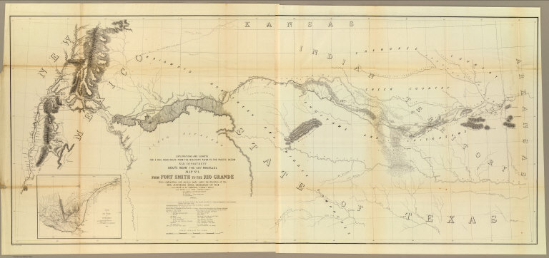
[Ives, J.C., Whipple, A.W.]
Full Title
From Fort Smith to the Rio Grande from explorations and surveys made under the direction of the Hon. Jefferson Davis, Secretary of War by Lieut. A.W. Whipple, Topogl. Engrs. and Lieut. J.C. Ives, Topogl. Engrs. A.H. Campbell, Civil Eng. and Surveyor, Asst. Surveyors: Wm. White Jr., N.H. Hutton, and J.P. Sherburne. 1853-4. Explorations and Surveys for a Rail Road Route from the Missisippi (sic) River to the Pacific Ocean, War Department, Route Near the 35th Parallel, Map No. 1. Engr. by Selmar Siebert.
List No
0693.037
Note
Map begins in the east at Ft. Smith (Arkansas) and continues along the Red River through Texas ending at the Rio Grande in present-day New Mexico. With inset map, "Sketch of the Rio Pecos at Anton Chico."
Author
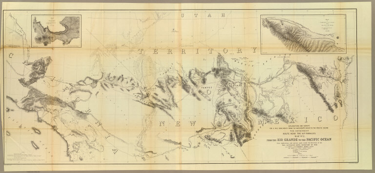
[Ives, J.C., Whipple, A.W.]
Full Title
From the Rio Grande to the Pacific Ocean from explorations and surveys made under the direction of the Hon. Jefferson Davis, Secretary of War by Lieut. A.W. Whipple, Topogl. Engrs. and Lieut. J.C. Ives, Topogl. Engrs. A.H. Campbell, Civil Eng. and Surveyor, Asst. Surveyors: Wm. White Jr., N.H. Hutton, and J.P. Sherburne. 1853-4. Explorations and Surveys for a Rail Road Route from the Mississippi River to the Pacific Ocean, War Department, Route Near the 35th Parallel, Map No. 2. Engr. by Selmar Siebert. Drawn by John D. Hoffmann.
List No
0693.038
Note
The uncolored map stretches from Albuquerque in the east across the southwest to Los Angeles. With two inset maps: "Sketch of Campbell's Pass from Agua Azul to Salt Spring" and "Sketch of Aztec Pass."
Author
[Campbell, A. H. (Albert H.), Ives, J.C., Whipple, A.W.]
Full Title
General profile from Fort Smith, Arkansas, to Martinez, near San Francisco, California, to accompany the maps of Explorations and Surveys made under the direction of Hon. Jefferson Davis, Secretary of War by Lieut. A.W. Whipple, Topl. engrs., assisted by Lieut. J.C. Ives, Topl. Engr., A.H. Campbell, civil engr. & surveyor, Wm. White, Jr., N.H. Hilton, J.P. Sherburne, asst. surveyors. 1853-4. Route near the 35th Parallel. (1861)
List No
0693.039
Note
Uncolored profiles. Horizontal scale 1:19,008.
Author
Parke, John G.
Full Title
From San Francisco Bay to the Plains of Los Angeles from Explorations and Surveys made under the direction of The Hon. Jefferson Davis, Secretary of War by Lieut. John G. Parke, Topl. Engrs. assisted by Albert H. Campbell, Civil Engineer and N.H. Hutton, H. Custer and G.G. Garner. 1854 & 55. Map No. 1. Constructed and drawn by H. Custer. Explorations and Surveys for a Rail Road Route from the Mississippi River to the Pacific Ocean. War Department. Coast Route, California.
List No
0693.046
Note
Uncolored map showing the proposed rail lines along the California coastal region. Note explains that the entire coastline was derived from the U.S. Coast Survey. Other information was taken from the surveys of the U.S. General Land Office.
Author
Parke, John G.
Full Title
From the Pimas Villages to Fort Fillmore from Explorations and Surveys made under the direction of The Hon. Jefferson Davis, Secretary of War by Lieut. John G. Parke, Topl. Engrs. assisted by Albert H. Campbell, Civil Engineer and N.H. Hutton, H. Custer and G.G. Garner. 1854 & 55. Map No. 2. Engr. by Selmar Siebert. Explorations and Surveys for a Rail Road Route from the Mississippi River to the Pacific Ocean. War Department. Route near the 32nd parallel of North Latitude.
List No
0693.047
Note
Area shown is just north of the boundary line between Mexico and the United States. Uncolored. Note states that some of the information on the map was taken from Emory survey and the office of the U.S. Mexican Boundary Commission.
Author
Parke, John G.
Full Title
Profiles from San Francisco Bay to Los Angeles, Cala. and from the Pimas Villages to Fort Fillmore from Explorations and Surveys made under the direction of The Hon. Jefferson Davis, Secretary of War by Lieut. John G. Parke, Topl. Engrs., assisted by Albert H. Campbell, Civil Engineer and N.H. Hutton, H. Custer and G.G. Garner, assts. 1854 & 55. Explorations and Surveys for a Rail Road Route from the Mississippi River to the Pacific Ocean. War Department. Route near the 32d parallel & coast route, Cala.
List No
0693.048
Note
Five uncolored profiles. Contents: No. 1. Profile from the Rio Grande opposite Fort Fillmore to the Rio Gila at Maricopa Wells, Pimas Villages -- No. 2. Profile from Los Angeles to San Francisco Bay, California Coast route -- No. 3. General profile near the 32d parallel, from Fulton on Red River, Arkansas to San Diego, California, via Fort Yuma and Warner's Pass -- No. 3a. Profile from Fort Yuma on Colorado River to San Francisco Bay via San Gorgonio Pass and Los Angeles, California -- No. 4. Profile of a proposed route for a railroad between the Port of San Diego and the Gila River, California from a survey made by direction of the San Diego and Gila Railroad Company by Charles H. Poole, Chief Engineer.
1-6 of 6
|