|
REFINE
Browse All : Book Map and Exploration Book by Humphreys, A.A.
1-9 of 9
Author
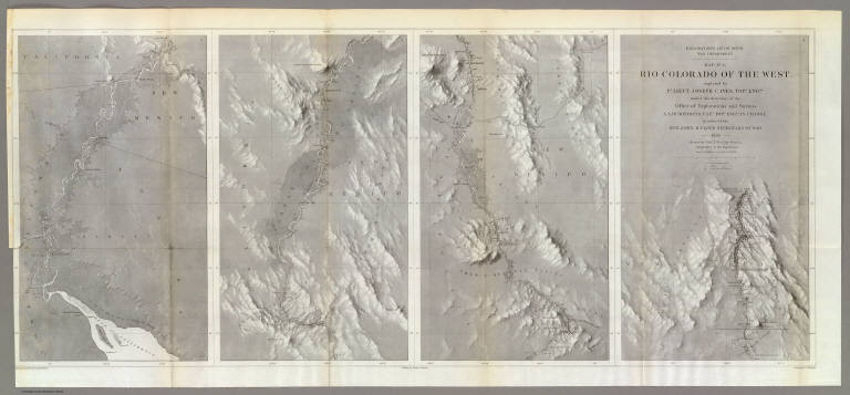
Ives, J.C.
Full Title
Explorations and Surveys. War Department. Map No. 1. Rio Colorado of the West, explored by 1st Lieut. Joseph C. Ives, Topl. Engrs. under the direction of the Office of Explorations and Surveys. A.A. Humphreys, Capt. Topl. Engrs. in Charge, by order of the Hon. John B. Floyd, Secretary of War. 1858. Drawn by Frhr. F.W.v. Egloffstein. Topographer to the Expedition. Topography by Frhr. F.W.v. Egloffstein. Ruling by Samuel Sartain. Lettering by F. Courtenay.
List No
0341.001
Note
Uncolored map in four parts across the page with the title on the far right map, with the maps reading from right to left. The detail of the map is superb, and shows the course of the Colorado River from its headwaters to the Gulf of California.
Author
Ives, J.C.
Full Title
Explorations and Surveys. War Department. Map No. 2. Rio Colorado of the West, explored by 1st Lieut. Joseph C. Ives, Topl. Engrs. under the direction of the Office of Explorations and Surveys. A.A. Humphreys, Capt. Topl. Engrs. in Charge, by order of the Hon. John B. Floyd, Secretary of War. 1858. Drawn by Frhr. F.W.v. Egloffstein. Topographer to the Expedition. Topography by Frhr. F.W.v. Egloffstein. Ruling by Samuel Sartain. Lettering by F. Courtenay.
List No
0341.002
Note
Uncolored map showing the Grand Canyon in superb detail. The "line of exploration" and camps are shown.
Author
Ives, J.C.
Full Title
Geological Map No. 1. Prepared by J.S. Newberry, M.D. Geologist to the Expedition. Explorations and Surveys. War Department. Map No. 1. Rio Colorado of the West, explored by 1st Lieut. Joseph C. Ives, Topl. Engrs. under the direction of the Office of Explorations and Surveys. A.A. Humphreys, Capt. Topl. Engrs. in Charge, by order of the Hon. John B. Floyd, Secretary of War. 1858. Drawn by Frhr. F.W.v. Egloffstein. Topographer to the Expedition. Topography by Frhr. F.W.v. Egloffstein. Ruling by Samuel Sartain. Lettering by F. Courtenay.
List No
0341.003
Note
Color washed map in four parts across the page with the title on the far right map, with the maps reading from right to left. The detail of the map is superb, and shows the course of the Colorado River from its headwaters to the Gulf of California.
Author
Ives, J.C.
Full Title
Geological Map No. 2. Prepared by J.S. Newberry, M.D. Geologist to the Expedition. Explorations and Surveys. War Department. Map No. 1. Rio Colorado of the West, explored by 1st Lieut. Joseph C. Ives, Topl. Engrs. under the direction of the Office of Explorations and Surveys. A.A. Humphreys, Capt. Topl. Engrs. in Charge, by order of the Hon. John B. Floyd, Secretary of War. 1858. Drawn by Frhr. F.W.v. Egloffstein. Topographer to the Expedition. Topography by Frhr. F.W.v. Egloffstein. Ruling by Samuel Sartain. Lettering by F. Courtenay.
List No
0341.004
Note
Color washed map showing the Grand Canyon in superb detail with geological information included. A key is added below the map. The "line of exploration" and camps are shown.
Author
[Ludlow, William, 1843-1901, United States. Army. Corps of Engineer]
Full Title
A geological map of the Black Hills: by Professor N.H. Winchell to accompany the report of Capt. William Ludlow U.S. Engineers. (to accompany) Report of a reconnaissance of the Black Hills of Dakota, made in the summer of 1874. By William Ludlow, Captain of Engineers, Bvt. Lieut. Colonel, U. S. Army; Chief Engineer Department of Dakota. Washington : Government Printing Office. 1875.
List No
0445.004
Note
Color geological map. Includes table of geologic formation. Relief shown by hachures and spot heights.
Author
[Ludlow, William, 1843-1901, United States. Army. Corps of Engineer]
Full Title
Map of a reconnaissance of the Black Hills of Dakota, July and August 1874. With troops under command of Lt. Col. G.A.Custer, 7th., Cavalry, by Capt. Wm. Ludlow, Corps of Engineers. (on upper margin) Brig. Genl. A.A.Humphreys, Chief of Engineers U.S.A. ; Brig. Genl. A.H. Terry Comdg. Department. (to accompany) Report of a reconnaissance of the Black Hills of Dakota, made in the summer of 1874. By William Ludlow, Captain of Engineers, Bvt. Lieut. Colonel, U. S. Army; Chief Engineer Department of Dakota. Washington : Government Printing Office. 1875.
List No
0445.006
Note
Uncolored map. Shows exploration routes and dates of reconnaissances and land conditions. Relief shown by hachures and spot heights. Includes notes indicating general topography.
Author
[Ludlow, William, 1843-1901, United States. Army. Corps of Engineer]
Full Title
Map of the Black Hills from a reconnaissance by Capt. Wm. Ludlow, Corps of Engineers. 1874, and map of Warren and Raynolds. Drawn by Sergt. C. Becker. (to accompany) Report of a reconnaissance of the Black Hills of Dakota, made in the summer of 1874. By William Ludlow, Captain of Engineers, Bvt. Lieut. Colonel, U. S. Army; Chief Engineer Department of Dakota. Washington : Government Printing Office. 1875.
List No
0445.007
Note
Uncolored map. Shows exploration routes and dates. Relief shown by hachures and spot heights. Includes notes indicating general topography.
Author
Warren, Gouverneur Kemble, 1830-1882
Full Title
Map Of The Territory Of The United States From The Mississippi To The Pacific Ocean Ordered by the Hon. Jeff'n Davis, Secretary Of War To accompany the Reports of the Explorations For A Railroad Route ... Compiled from authorized explorations and other reliable data by Lieut. G.K. Warren, Topl. Engrs. In the Office of Pacific R.R. Surveys, War Dep. under the direction of Bvt. Maj. W.H. Emory, Topl Engrs. in 1854 and of Capt. A.A. Humphreys, Topl. Engrs. 1854-5-6-7. Engr. by Selmar Siebert.
List No
0693.018
Note
The general map published with the Pacific Railroad Survey Reports. This map had earlier issues and later issues. A preliminary listed of those would be: 1855 (our #2289); 1857 (WH and AH's copies)- blank areas in eastern Oregon, fewer authorities; 1857 published with the reports; 1858 early (see Schubert);1858 late (our #2750); 1867 (our #2594). We suspect there are other states and issues, particularly in the period of 1859 to 1866. This is one of the most important maps of the West in the 1850's and 1860's and a study of its different states shows the rapid growth of topographical information from government exploration and mapping. Without color.
Author
[Abbot, Henry L., Humphreys, A.A., Warren, Gouverneur Kemble, 1830-1882]
Full Title
Profiles of the main routes surveyed, compiled in 1855, by Lieutenants G.K. Warren & H.L. Abbot, Corps Topl. Engineers; with revisions and additional compilations from the results of subsequent examinations and surveys. Prepared in the Office of Pacific Rail Road Explorations and Surveys. Captain A.A. Humphreys, Corps Topl. Engineers, in charge, by direction of Hon. Jefferson Davis, Secretary of War. 1856. Explorations and Surveys for the Rail Road Routes from the Mississippi River to the Pacific Ocean, War Department. (with) Profiles of rail roads constructed across the Alleghany mountains.
List No
0693.019
Note
Uncolored map profiles with inset profile. Printed on 2 sheets; joined as 1.
1-9 of 9
|