|
REFINE
Browse All : Railroad by Humphreys, A.A. and Freyhold, Edward
1-3 of 3
Author
Warren, Gouverneur Kemble, 1830-1882
Full Title
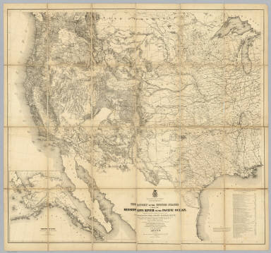
Map Of The Territory Of The United States From The Mississippi River To The Pacific Ocean; Originally prepared to accompany the Reports of the Explorations For A Pacific Railroad Route ... Compiled from authorized explorations and other reliable data by Lieut. G.K. Warren, Top'l. Eng'rs. In the Office of Pacific R.R. Surveys, War Dept. under the direction of Bvt. Maj. W.H. Emory, Top'l. Eng'rs. in 1854. Capt. A.A. Humphreys, Top'l. Eng'rs. in 1854-58. And partly recompiled and redrawn under the direction of the Engineer Bureau in 1865-66-67. Engineer Bureau, War Department. Engraved on stone by Julius Bien, New York.
List No
2594.000
Note
Reissue, with new discoveries, of 1857 Warren "Map of the Territory of the United States..." Although Freyhold's name is not on the title, he clearly redrew this map from his earlier 1858 edition (where his name does appear on the title). This is earlier than the 1868 Warren/Freyhold editions (Streeter 3080 and 3081), and should be distinguished from them in having the title still in the lower left corner (not in the lower center as in the 1868 Warren/Freyhold editions), and because it does not have the Alaska inset, has 47 authorities vs. 48, and is dated Aug 26, 1867 in Ms. next to the same inscription mentioned by Streeter on his later copy (Wm. E. Merrill, etc., which Streeter mistakes for E. Hamill). Mail routes in red ink (original?)(Streeter says they were dropped from the second 1868 ed.) plus many interesting Ms. additions of names of forts, and extension of pacific railroad. Cf. Wheat 1185. Wheat does not mention this edition and was not aware of it (see his "correction" of Wheeler's mention of the map in the note, p. 244). See a very informative article by Lewis Buttery on a slightly earlier state of this map (early 1867) found at West Point - "Warren Map of 1867." Outline color. Map is dissected into 24 sections, edged in blue silk, and folded into a new burgundy cloth folding case 30x22 with "Warren & Freyhold. Map of Exploratations (sic) for Pacific R.R. 1865-67" stamped in gilt.
Author
[Freyhold, Edward, Warren, Gouverneur Kemble, 1830-1882]
Full Title
Map Of The Territory Of The United States From The Mississippi To The Pacific Ocean; Ordered by the Hon. Jeff'n Davis, Secretary Of War To accompany the Reports of the Explorations For A Railroad Route ... Compiled from authorized explorations and other reliable data by Lieut. G.K. Warren, Topl. Engrs. In the Office of Pacific R.R. Surveys, War Dep. under the direction of Bvt. Maj. W.H. Emory, Topl. Engrs. in 1854 and of Capt. A.A. Humphreys, Topl. Engrs. 1854-5-6-7-8. Drawn by E. Freyhold. Engr. on Stone by J. Bien, 60 Fulton St. N.Y.
List No
2750.000
Note
2nd 1858 edition, adds Ives Grand Canyon expedition. Also adds information from Warren's third expedition. Schubert says there was an earlier 1858 edition that filled in information in Oregon but did not include the Ives information. Schubert also quotes a letter from Warren stating that this edition was sent to the printer in 1859. Freyhold's name appears on the title for the first time. It is dropped in the next (1867) edition and then reappears in the 1868 edition. Rare - apparently there is only one other copy of this map - in the Millard Fillmore Map Collection in the LOC (see Stephenson article in Map Collector No. 12). This copy came from the Bancroft Library as a duplicate - perhaps they thought it was a duplicate of the 1857 edition. With brown wood side rollers. Map is without color and mounted on linen.
Author
[Freyhold, Edward, Warren, Gouverneur Kemble, 1830-1882]
Full Title
Territory Of The United States From The Mississippi River To The Pacific Ocean; Originally prepared to accompany the Reports of the Explorations For A Pacific Railroad Route ... Compiled from authorized explorations and other reliable data by Lieut. G.K. Warren, Top'l. Eng'rs. In the Office of Pacific R.R. Surveys, War Dept. under the direction of Bvt. Maj. W.H. Emory, Top'l. Eng'rs. in 1854. Capt. A.A. Humphreys, Top'l. Eng'rs. in 1854-58. Recompiled and redrawn under the direction of the Chief of Corps of Engineers By Edward Freyhold 1865-66-67-68. Head Quarters Corp Of Engineers, War Department. Engraved & printed by Julius Bien, N.Y. (inset) Territory Of Alaska Ceded By Russia To The United States 1868.
List No
2919.000
Note
Alaska inset; 59 "authorities"; Streeter copy. Wheat: "one of the great American maps, and one profoundly influential." The final revision of the original Warren map of 1857; largely redrawn, in substance, and style of hachuring. An earlier state of the same imprint is described in Streeter 3080. See Wheeler vol 1 reference. In 1879 Freyhold issued another larger version of this map (Wheat 1295) (see our copy). Without color. Dissected into 24 sections and mounted on linen. Folds into a new burgundy cloth folding case 30x22 with original spine label reading "Freyhold - Map Of Explorations For Pacific R.R. - Recompiled 1865-68."
1-3 of 3
|