|
REFINE
Browse All : Images by Hassel, S. G. H., 1779-1829 of North America from 1827
1-4 of 4
Author
Vandermaelen, Philippe, 1795-1869
Full Title
Tableau provisoire d'assemblage d'une partie de l'Amerique Seple. et d'une partie de l'Amerique Meridionale. (Dresse par Ph. Vandermaelen, lithographie par H. Ode. Quatrieme partie. - Amer. sept. Bruxelles. 1827)
List No
2212.204
Note
Hand col. lithographed index map. Relief shown pictorially. Prime meridian: Paris.
Author
Vandermaelen, Philippe, 1795-1869
Full Title
Carte d'assemblage de l'Amerique Septenle. (Dresse par Ph. Vandermaelen, lithographie par H. Ode. Quatrieme partie. - Amer. sept. Bruxelles. 1827)
List No
2212.205
Note
Hand col. lithographed index map. Relief shown pictorially. Prime meridian: Paris. Includes inset of Russian America.
Author
Vandermaelen, Philippe, 1795-1869
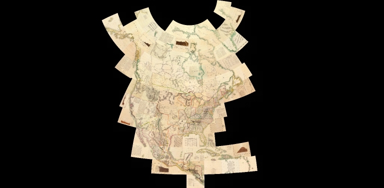
Full Title
(Composite of) Amer. Sep. no. 1 - 76. (Dresse par Ph. Vandermaelen, lithographie par H. Ode. Quatrieme partie. - Amer. sept. Bruxelles. 1827)
List No
2212.391
Note
This composite of all 76 maps of North America was created by georeferencing the maps individually in a Polyconic projection with the central meridian at 88.5 degrees west. Then all the maps were trimmed beyond their neat lines and joined. Relief shown pictorially; depths by soundings. Prime meridian: Paris. Covers North America.
Author
Vandermaelen, Philippe, 1795-1869
Full Title
(Composite of) Amer. Sep. no. 1 - 76 and Amer. Merid. no. 1 - 43. (Dresse par Ph. Vandermaelen, lithographie par H. Ode. 1827)
List No
2212.394
Note
This composite of all 119 maps of North and South America was created by georeferencing the maps individually in a Polyconic projection with the central meridian at 88.5 degrees west. Then all the maps were trimmed beyond their neat lines and joined. Relief shown pictorially; depths by soundings. Prime meridian: Paris.
1-4 of 4
|