|
REFINE
Browse All : Separate Map by Harrison, Richard Edes of World
1-16 of 16
Author
[Harrison, Richard Edes, Industrial Services Division, Bureau of Public Relations, War Department]
Full Title
Newsmap : Monday, November 29, 1943. Week of November 18 to November 25, 220th week of the War - 102th week of U. S. participation. Volume II No. 32. Basemap drawn by Richard Edes Harrison, © Time Inc. 1940. Distributed by Industrial Services Division, Bureau of Public Relations, War Department. Prepared from public sources of information. U. S. Government Printing Office: 1943.
List No
14188.000
Note
Lithographed world map, in black, gray, blue and white. Shows political boundaries and represents military events of World War II, from November 18 to 25, 1943. Relief illustrated with hachures. Includes a distance table: Tokio to ... Accompanying historical notes describe the war fronts: USSR -- New Guinea -- Gilbert and Marshall Islands -- Bougainville -- Air offensive -- Italy. Features photographs. With three inset maps: Berlin -- (Western Hemisphere) -- (Eastern Hemisphere). Map is 85 x 85 cm, on sheet 89 x 120 cm, folded to 31 x 23 cm. Stamp on verso: Received Nov 1 1943 C. E. King.
Author
Harrison, Richard Edes
Full Title
The Big Network. How the World Communications System reaches into the U.S.
List No
10912.000
Note
Shows Cable and Radio networks worldwide. Also shows political alignment of countries just before World War II. Two inset maps. Drawn by Richard Edes Harrison for TIME Fortune weekly magazine. Published as supplement to Fortune Magazine, 1939.
Author
[Pan American World Airways, Inc., Harrison, Richard Edes, Carlton Smith Associates, Pictograph Corporation, Quarrie Corporation]
Full Title
(Covers to) The wealth of the other Americas. Copyright 1945 Pan American World Airways, Inc. Basic map by Richard Edes Harrison. Map symbols copyrighted by Pictograph Corp. and Quarrie Corp. Designed by Carlton Smith Associates, New York. Printed by Wander Press, New York.
List No
11590.001
Note
Promotional pictorial Pan American World Airways calendar in 28 pages, with 14 maps. Covers February 1945 to January 1946. "Acknowledgment: for much of the source materials used in the preparation of this calendar is given to: U.S. Dept. of Commerce (Bureau of Foreign and Domestic Commerce), Pan American Union, Pictograph Corporation and Quarrie Corporation". Front cover: Map of the world, shows the routes of the flying clipper in the world, view of Flying Clipper and text on both sides. Text on cover: "This 1945 calendar has many unusual features. It is more than a month-to-month time table, it is an authoritative, up-to-date encyclopedia ..." Back cover: "No Fantasy here", map of Latin America and United States, showing Pan American service routes. Each month showing a different destination in Latin America, includes pictorial map, illustrations and views, with information on various cities, populations, landmarks and points of interest on verso. Maps showing capitals, agriculture, industry, and landmarks. Includes views, notes and location map. Relief shown by shadings.
Author
[Geisel, Theodor Seuss, Army Orientation Course, Special Service Division Army Service Forces]
Full Title
This is Ann ... she drinks blood. Her full name is Anopheles Mosquito and she's dying to meet you! ... Prepared and distributed by Army Orientation Course, Special Service Division, Army Service Forces. War Dept., Washington, D.C. Government printing Office, 1943, 538110. (on verso) Newsmap : Monday, November 8, 1943 : week of October 28 to November 4 : 217th week of the war : 99th week of U.S. participation. Volume II, No. 29. Drawn by Richard Edes Harrison, 1940. Time Inc. (Fortune).
List No
11241.001
Note
4 maps on 1 sheet, both sides, sheet 88x119. Map of the world printed in red and black, by Theodore Geisel and Munro Leaf; Army Orientation Course, Special Service Division. With color coded reference: "Malaria found wherever you see red on the map". One element of the anti-malaria campaign was an effort to educated front-line soldiers and to control the disease through aggressive prevention and public health measures. On verso: Maps: Bougainville : last stop in the Solomons; Crimea is cut off; Atlantic Ocean. Includes text: War fronts: Russia, Italy, Air offensive, Southwest Pacific, Burma. Photographs: Navy's new Hellcat fighter plane brings down a Japanese fighter plane nicknamed "Emily" near the Gilbert Islands. "Prepared from public sources of information."
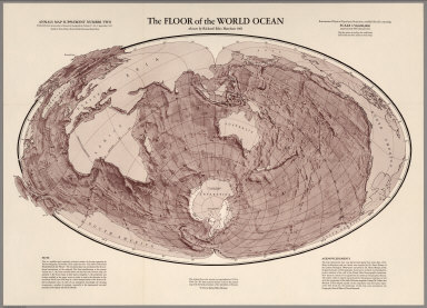
Author
Harrison, Richard Edes
Full Title
The Floor of the World Ocean.
List No
6370.000
Note
Modified Briesmeister Elliptical Equal-Area Projection. Map Supplement Number Two, Annals of the Association of American Geographers, Volume 51, No.3, September 1961.
Author
Harrison, Richard Edes
Full Title
Atlantic Arena. A Fortune map : Orthographic series I. Drawn by Richard Edes Harrison supplement to Fortune June, 1942. Copyright 1942 Time Inc.
List No
11086.000
Note
Full color. Supplement to Fortune (Magazine) June 1942. Richard Edes Harrison's innovative maps of the 1940s, illustrating information and facts about the war that are critical to the history of American cartography. Shows neutral areas and Allies, pro Ally and Axis and pro Axis occupied areas. Includes text, diagrams, and legend. Orthographic Projection.
Author
[Harrison, Richard Edes, Army Orientation Course, Special Service Division Army Service Forces]
Full Title
Newsmap : Monday, November 8, 1943 : week of October 28 to November 4 : 217th week of the war : 99th week of U.S. participation. Volume II, No. 29. Drawn by Richard Edes Harrison, 1940. Time Inc. (Fortune). (on verso) This is Ann ... she drinks blood. Her full name is Anopheles Mosquito and she's dying to meet you! ... Prepared and distributed by Army Orientation Course, Special Service Division, Army Service Forces. War Dept., Washington, D.C. Government printing Office, 1943, 538110.
List No
11241.002
Note
4 maps on 1 sheet, both sides, sheet 88x119. Map of the world printed in red and black, by Theodore Geisel and Munro Leaf; Army Orientation Course, Special Service Division. With color coded reference: "Malaria found wherever you see red on the map". One element of the anti-malaria campaign was an effort to educated front-line soldiers and to control the disease through aggressive prevention and public health measures. On verso: Maps: Bougainville : last stop in the Solomons; Crimea is cut off; Atlantic Ocean. Includes text: War fronts: Russia, Italy, Air offensive, Southwest Pacific, Burma. Photographs: Navy's new Hellcat fighter plane brings down a Japanese fighter plane nicknamed "Emily" near the Gilbert Islands. "Prepared from public sources of information."
Author
Harrison, Richard Edes
Full Title
World Island. A Fortune Map. Orthographic Series III.
List No
6759.000
Note
Includes notes on geopolitics and the projection.
Author
Harrison, Richard Edes
Full Title
Pacific Arena. A Fortune Map. Orthographic Series II.
List No
6762.000
Note
Includes notes on geopolitics and the projection.
Author
Harrison, Richard Edes
Full Title
One world, one war; a map showing the line-up and the strategic stakes in this the first global war. Drawn by Richard Harrison. C(opyright) Time Inc. (Fortune, March 1942). (insets) The Atlantic Bridge. (with) the Pacific Vastness.
List No
8129.000
Note
Map color coded by The line-up, February 1, 1942. Supplement to Fortune. March, 1942 Time Inc. Includes notes on projection, and text and maps of "The Atlantic bridge" and "The "Pacific vastness". Allied Supply routes shown in brown lines. North polar Azimuthal equidistant projection.
Author
[Pan American World Airways, Inc., Harrison, Richard Edes]
Full Title
Pan American world airways : The system of the flying clippers. Copyright by Pan American Airways, inc. Corrected to February 1, 1947. Printed by Richard Edes Harrison.
List No
8283.000
Note
Full color map. Legend includes Pan American world airway system: US flag carriers, US flag carries proposed services and affiliated carriers. Shows countries, and major cities. Relief shown by shadings.
Author
[Culbertson, Ely, Harrison, Richard Edes]
Full Title
The eleven Regional Federation comprising the World Federation System. Ely Culbertson, 1943. Projection ... Richard Edes Harrison. (Cover title) the World Federation system.
List No
8378.001
Note
Color map of the world, on sheet 39.5x40.5, folded into shelf wrapped cover 20x13.5, showing Ely Culbertson' color coded division of the world into eleven regional federations, shifting of existing political alignments, and the creation of an international police force. Azmuthal Equidistance projection. On verso: text: "The Quota force principal"; "The structure and relationship of American and Malaysian Federation", 3 views, and illustrations. Projection, courtesy of Richard Edes Harrison.
Author
Harrison, Richard Edes
Full Title
U.S.N. Ships - Bases - Men As of January 1938.
List No
8828.000
Author
[Harrison, Richard Edes, Army Information Branch, Army Service Forces]
Full Title
Newsmap. For the Armed Forces. Monday, December 25, 1944 ... Vol. III. No 36F. Prepared and Distributed by the Army Information Branch, Army Service Forces. Mindoro. Pacific War in the Air. Western Action.
List No
9014.001
Note
Includes photos, text, and 3 maps.
Author
Harrison, Richard Edes
Full Title
The world divided. Richard Edes Harrison, July 1941. The world centrifuged : North - Polar Azmuthal Equidistant Projection.
List No
9808.000
Note
Color map on 2 sheets, made by Richard Edes Harrison, Fortune magazine. Shows water and air routes, U.S. military missions and financial aid. Includes notes text: "The political alignments of the world are here shown, centering geographically around the North Pole but ideologically and economically around the U.S. The classification keyed below is necessarily simplified and does not of course meet all the subtleties of politics and diplomacy - for instance, the peculiar position of Vichy and its colonies. The special case of the U.S.S.R. is acknowledged by a special color. The situation is as of July 7, 1941, and is subject to change without notice." and notes.
Author
[Harrison, Richard Edes, Standard Oil Company of New Jersey]
Full Title
The world according to Standard (N.J.) : How a great oil company works in time of peace and how the war is affecting it. Richard Edes Harrison March 1940.
List No
9882.000
Note
Pictorial map of the world, prepared by freelance cartographer Richard Harrison, in cartographic design, Harrison invented an “oil drop” world projection. Published in ''Fortune'' magazine, vol. 21, no. 5 (May 1940). He prepared a map to illustrate the company's international operations at the beginning of World War II, which emphasized Texas and Venezuela, Standard Oil's major areas of crude oil production and the location of refineries. Flow lines show the movement of crude oil (colored dark brown) and refined oil (shown in a lighter yellow) by pipeline or tanker. Highlighted comments describe particular areas of difficulties for the company at the beginning of the war. also showing tankers, and flags "The area of the flags is proportional to the tonnage (1940)".
1-16 of 16
|