|
REFINE
Browse All : Images by H.S. Tanner from 1839
1-21 of 21
Author
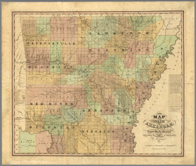
Stebbins, Henry S.
Full Title
A new map of the state of Arkansas, constructed principally from the United States surveys exhibiting the counties, townships & sections by H.S. Tanner. Published by H.S. tanner, Philadelphia. Entered according to Act of Congress in ... 1839, by H.S. Tanner in ... Eastern District of Pennsylvania.
List No
7634.000
Note
An extremely rare map of Arkansas and the earliest large format map of the state, published less than 3 years after its admission to the Union on June 15, 1836. Tanner's map depicts the new state divided by the Survey of Public Lands into the "Lawrence," "Arkansas," "Fayetteville," and "Red River" Districts and further subdivided into its 30 original counties. The familiar grid of townships and sections imposed by the Survey of Public Lands dominates the mapthis closely matches a Map of Arkansas Surveying District published by the General Land Office later in 1839 and is evidence that Tanner used the most up-to-date sources. Overall, Arkansas settlement was strikingly sparse at this early date, with the total population still under 100,000 and heavily concentrated in the eastern counties. Of particular interest are Miller and Lafayette Counties in the far southwest, at the time the subject of a territorial dispute with the then-independent Republic of Texas. Here they are assigned a somewhat ambiguous status, depicted within Arkansas' borders but not included in the Arkansas Survey District. All of Miller was ceded to Texas when it became a state in 1845, but the county was later reconstituted from the western portion of Lafayette County. Hand colored map. Includes notes and legend. Shows state, county, township, and district boundaries, railroads and roads,Trails, canals, rivers, and topographical features such as prairies and swamps. Relief shown by hachures. Prime meridian is Washington.
Author
Tanner, Henry S.
Full Title
United States.
List No
0980.010
Author
Tanner, Henry S.
Full Title
Connecticut by H.S. Tanner.
List No
0980.014
Author
Tanner, Henry S.
Full Title
A New Map of Georgia with Its Canals, Roads & Distances by H.S. Tanner.
List No
0980.022
Author
Tanner, Henry S.
Full Title
Florida. (insets) Pensacole. Tallahassee. St. Augustine.
List No
0980.023
Author
Tanner, Henry S.
Full Title
A New Map of Louisiana with Its Roads & Distances from place to place along the Stage & Steam Boat Routes by H.S. Tanner. (inset) New Oreleans.
List No
0980.026
Author
Tanner, Henry S.
Full Title
A New Map of Kentucky with Its Roads & Distances from place to place along the Stage & Steam Boat Routes by H.S. Tanner. (insets) Falls of Ohio. (Environs of) Clarksburg. (Environs of Lexington).
List No
0980.029
Author
Tanner, Henry S.
Full Title
(Covers and Title Page to) United States of America: by H.S. Tanner, 1839. Philadelphia, Published by Henry S. Tanner. Entered ... 1838, by H.S. Tanner ... Pennsylvania. Engraved by H.S. Tanner, assisted by E.B. Dawson, W. Allen & J. Knight. (title by) J.W. Steel Sc. (with 17 inset maps and 1 profile). (with index) An alphabetical index to the four sheet map of the United States by H. S. Tanner. Philadelphia: Rackliff and Jones, Printers, South-West Corner of George and Swanwick streets.
List No
4845A
Note
Covers to map, and cover and title page of index. The seventh edition. Michigan peninsula has been substantially redrawn, the profiles in the lower left corner of the map have been eliminated to reveal a good bit of Republican Texas, Wisconsin and Iowa are shown, Missouri is enlarged in the northwestern corner, and new counties are added in most of the settling states. This is a major revision of the map. There is added a new key index system of numbers (and letters for Texas) to go with an attached "Alphabetical Index to the Four Sheet Map of The United States" (see our #4846). The index is bound in patterned tan cloth covered boards 18.5x11 with a label reading "Index Of Places, Contained On Tanner's Map Of The United States." Most copies of this map are either colored in outline or in full color by state; this copy is in full color by county - the only such example we have seen. Streeter Texas 1232 is the 1836 edition of this map, which apparently shows Texas in much the same form and includes the separate index volume. Map is edged in green cloth, dissected into 60 sections and mounted on linen. Folds with marbled end sheets into the original half leather red cloth covers 22x17 with ties; title on the spine is stamped in gold and reads "Map Of The United States With Index 1839."
Author
Tanner, Henry S.
Full Title
United States of America: by H.S. Tanner, 1839. Philadelphia, Published by Henry S. Tanner. Entered ... 1838, by H.S. Tanner ... Pennsylvania. Engraved by H.S. Tanner, assisted by E.B. Dawson, W. Allen & J. Knight. (title) J.W. Steel Sc. (with 17 inset maps and 1 profile). (with index) An Alphabetical Index To The Four Sheet Map Of The United States, By H. S. Tanner. Philadelphia: Rackliff And Jones, Printers, South-West corner of Geogre and Swanwick streets.
List No
4845.001
Note
The seventh edition. Michigan peninsula has been substantially redrawn, the profiles in the lower left corner of the map have been eliminated to reveal a good bit of Republican Texas, Wisconsin and Iowa are shown, Missouri is enlarged in the northwestern corner, and new counties are added in most of the settling states. This is a major revision of the map. There is added a new key index system of numbers (and letters for Texas) to go with an attached "Alphabetical Index to the Four Sheet Map of The United States" (see our #4846). The index is bound in patterned tan cloth covered boards 18.5x11 with a label reading "Index Of Places, Contained On Tanner's Map Of The United States." Most copies of this map are either colored in outline or in full color by state; this copy is in full color by county - the only such example we have seen. Streeter Texas 1232 is the 1836 edition of this map, which apparently shows Texas in much the same form and includes the separate index volume. Map is edged in green cloth, dissected into 60 sections and mounted on linen. Folds with marbled end sheets into the original half leather red cloth covers 22x17 with ties; title on the spine is stamped in gold and reads "Map Of The United States With Index 1839."
Author
Tanner, Henry S.
Full Title
(Covers to) The American Traveller; Or Guide Through the United States. Containing Brief Notices Of The Several States, Cities, Principal Towns, Canals And Rail Roads, &c. With Tables of Distances ... The whole Alphabetically arranged, with direct Reference to the accompanying Map of the Roads, Canals, and Railways of the United States. Fourth Edition. By H.S. Tanner. Philadelphia: Published By The Author, No. 309 Market Street. 1839. (with) The Travellers Guide Or Map Of The Roads, Canals & Rail Roads of the United States, With the distances from place to place By H.S. Tanner. Entered ... 1834, by H.S. Tanner ... Pennsylvania. (with 4 city maps).
List No
5399.001
Note
Guide is bound in purple cloth covers 15x9 with a printed paper label reading "Tanner's American Traveller, Or Guide Through The United States." The large map is hand colored in outline, and has 17 inset views of cities or regions. The map is unchanged from the 1836 third edition. The four small maps are uncolored, and are of Baltimore, Boston, Philadelphia, and New York.
Author
Tanner, Henry S.
Full Title
(Title Page to) The American Traveller; Or Guide Through the United States. Containing Brief Notices Of The Several States, Cities, Principal Towns, Canals And Rail Roads, &c. With Tables of Distances ... The whole Alphabetically arranged, with direct Reference to the accompanying Map of the Roads, Canals, and Railways of the United States. Fourth Edition. By H.S. Tanner. Philadelphia: Published By The Author, No. 309 Market Street. 1839. (on verso) Entered ... 1836, by H.S. Tanner ... Pennsylvania. (with) The Travellers Guide Or Map Of The Roads, Canals & Rail Roads of the United States, With the distances from place to place By H.S. Tanner. Entered ... 1834, by H.S. Tanner ... Pennsylvania. (with 4 city maps). (on recto of title page: view of) " Falls Of Niagara. From the American ladder. Drawn by T. Birch. Engraved by J.W. Steel.
List No
5399.002
Note
Guide is bound in purple cloth covers 15x9 with a printed paper label reading "Tanner's American Traveller, Or Guide Through The United States." The large map is hand colored in outline, and has 17 inset views of cities or regions. The map is unchanged from the 1836 third edition. The four small maps are uncolored, and are of Baltimore, Boston, Philadelphia, and New York.
Author
Tanner, Henry S.
Full Title
The Travellers Guide Or Map Of The Roads, Canals & Rail Roads of the United States, With the distances from place to place By H.S. Tanner. Published by H.S. Tanner ... Philadelphia. Entered ... 1834, by H.S. Tanner ... Pennsylvania. (to accompany) The American Traveller; Or Guide Through the United States. Containing Brief Notices Of The Several States, Cities, Principal Towns, Canals And Rail Roads, &c. With Tables of Distances ... The whole Alphabetically arranged, with direct Reference to the accompanying Map of the Roads, Canals, and Railways of the United States. Fourth Edition. By H.S. Tanner. Philadelphia: Published By The Author, No. 309 Market Street. 1839. (on verso) Entered ... 1836, by H.S. Tanner ... Pennsylvania.
List No
5399.003
Note
Hand colored in outline map, has 17 inset maps of cities or regions. The map is unchanged from the 1836 third edition. Guide is bound in purple cloth covers 15x9 with a printed paper label reading "Tanner's American Traveller, Or Guide Through The United States." The four small maps are uncolored, and are of Baltimore, Boston, Philadelphia, and New York.
Author
Tanner, Henry S.
Full Title
Philadelphia And Environs. (to accompany) The American Traveller; Or Guide Through the United States. Containing Brief Notices Of The Several States, Cities, Principal Towns, Canals And Rail Roads, &c. With Tables of Distances ... The whole Alphabetically arranged, with direct Reference to the accompanying Map of the Roads, Canals, and Railways of the United States. Fourth Edition. By H.S. Tanner. Philadelphia: Published By The Author, No. 309 Market Street. 1839. (on verso) Entered ... 1836, by H.S. Tanner ... Pennsylvania. (with) The Travellers Guide Or Map Of The Roads, Canals & Rail Roads of the United States, With the distances from place to place By H.S. Tanner. Entered ... 1834, by H.S. Tanner ... Pennsylvania. (with 4 city maps). (on recto of title page: view of) " Falls Of Niagara. From the American ladder. Drawn by T. Birch. Engraved by J.W. Steel.
List No
5399.004
Note
Uncolored map, with References to places. Guide is bound in purple cloth covers 15x9 with a printed paper label reading "Tanner's American Traveller, Or Guide Through The United States." The large map is hand colored in outline, and has 17 inset views of cities or regions. The map is unchanged from the 1836 third edition. The four small maps are uncolored, and are of Baltimore, Boston, Philadelphia, and New York.
Author
Tanner, Henry S.
Full Title
New York. (to accompany) The American Traveller; Or Guide Through the United States. Containing Brief Notices Of The Several States, Cities, Principal Towns, Canals And Rail Roads, &c. With Tables of Distances ... The whole Alphabetically arranged, with direct Reference to the accompanying Map of the Roads, Canals, and Railways of the United States. Fourth Edition. By H.S. Tanner. Philadelphia: Published By The Author, No. 309 Market Street. 1839. (on verso) Entered ... 1836, by H.S. Tanner ... Pennsylvania. (with) The Travellers Guide Or Map Of The Roads, Canals & Rail Roads of the United States, With the distances from place to place By H.S. Tanner. Entered ... 1834, by H.S. Tanner ... Pennsylvania. (with 4 city maps). (on recto of title page: view of) " Falls Of Niagara. From the American ladder. Drawn by T. Birch. Engraved by J.W. Steel.
List No
5399.005
Note
Uncolored map, with References to places. Guide is bound in purple cloth covers 15x9 with a printed paper label reading "Tanner's American Traveller, Or Guide Through The United States." The large map is hand colored in outline, and has 17 inset views of cities or regions. The map is unchanged from the 1836 third edition. The four small maps are uncolored, and are of Baltimore, Boston, Philadelphia, and New York.
Author
Tanner, Henry S.
Full Title
Boston (to accompany) The American Traveller; Or Guide Through the United States. Containing Brief Notices Of The Several States, Cities, Principal Towns, Canals And Rail Roads, &c. With Tables of Distances ... The whole Alphabetically arranged, with direct Reference to the accompanying Map of the Roads, Canals, and Railways of the United States. Fourth Edition. By H.S. Tanner. Philadelphia: Published By The Author, No. 309 Market Street. 1839. (on verso) Entered ... 1836, by H.S. Tanner ... Pennsylvania. (with) The Travellers Guide Or Map Of The Roads, Canals & Rail Roads of the United States, With the distances from place to place By H.S. Tanner. Entered ... 1834, by H.S. Tanner ... Pennsylvania. (with 4 city maps). (on recto of title page: view of) " Falls Of Niagara. From the American ladder. Drawn by T. Birch. Engraved by J.W. Steel.
List No
5399.006
Note
Uncolored map, with References to places. Guide is bound in purple cloth covers 15x9 with a printed paper label reading "Tanner's American Traveller, Or Guide Through The United States." The large map is hand colored in outline, and has 17 inset views of cities or regions. The map is unchanged from the 1836 third edition. The four small maps are uncolored, and are of Baltimore, Boston, Philadelphia, and New York.
Author
Tanner, Henry S.
Full Title
Baltimore (to accompany) The American Traveller; Or Guide Through the United States. Containing Brief Notices Of The Several States, Cities, Principal Towns, Canals And Rail Roads, &c. With Tables of Distances ... The whole Alphabetically arranged, with direct Reference to the accompanying Map of the Roads, Canals, and Railways of the United States. Fourth Edition. By H.S. Tanner. Philadelphia: Published By The Author, No. 309 Market Street. 1839. (on verso) Entered ... 1836, by H.S. Tanner ... Pennsylvania. (with) The Travellers Guide Or Map Of The Roads, Canals & Rail Roads of the United States, With the distances from place to place By H.S. Tanner. Entered ... 1834, by H.S. Tanner ... Pennsylvania. (with 4 city maps). (on recto of title page: view of) " Falls Of Niagara. From the American ladder. Drawn by T. Birch. Engraved by J.W. Steel.
List No
5399.007
Note
Uncolored map, with References to places. Guide is bound in purple cloth covers 15x9 with a printed paper label reading "Tanner's American Traveller, Or Guide Through The United States." The large map is hand colored in outline, and has 17 inset views of cities or regions. The map is unchanged from the 1836 third edition. The four small maps are uncolored, and are of Baltimore, Boston, Philadelphia, and New York.
Author
Tanner, Henry S.
Full Title
(Views to) Water Works-Fairmont. Morning. G. Lehman Del. J.W. Steel. Sculp. Brandywine Light House. Delaware Bay. Birch Del. J.W. Steel. Sculp. (to accompany) The American Traveller; Or Guide Through the United States. Containing Brief Notices Of The Several States, Cities, Principal Towns, Canals And Rail Roads, &c. With Tables of Distances ... The whole Alphabetically arranged, with direct Reference to the accompanying Map of the Roads, Canals, and Railways of the United States. Fourth Edition. By H.S. Tanner. Philadelphia: Published By The Author, No. 309 Market Street. 1839. (on verso) Entered ... 1836, by H.S. Tanner ... Pennsylvania. (with) The Travellers Guide Or Map Of The Roads, Canals & Rail Roads of the United States, With the distances from place to place By H.S. Tanner. Entered ... 1834, by H.S. Tanner ... Pennsylvania. (with 4 city maps). (on recto of title page: view of) " Falls Of Niagara. From the American ladder. Drawn by T. Birch. Engraved by J.W. Steel.
List No
5399.008
Note
Two uncolored views. Guide is bound in purple cloth covers 15x9 with a printed paper label reading "Tanner's American Traveller, Or Guide Through The United States." The large map is hand colored in outline, and has 17 inset views of cities or regions. The map is unchanged from the 1836 third edition. The four small maps are uncolored, and are of Baltimore, Boston, Philadelphia, and New York.
Author
Tanner, Henry S.
Full Title
(Views to) Niagara Falls. Birch Del. J.W. Steel Sculp. West Point, from Cadets Monument. Doughty Del. J.W. Steel Sculp. (to accompany) The American Traveller; Or Guide Through the United States. Containing Brief Notices Of The Several States, Cities, Principal Towns, Canals And Rail Roads, &c. With Tables of Distances ... The whole Alphabetically arranged, with direct Reference to the accompanying Map of the Roads, Canals, and Railways of the United States. Fourth Edition. By H.S. Tanner. Philadelphia: Published By The Author, No. 309 Market Street. 1839. (on verso) Entered ... 1836, by H.S. Tanner ... Pennsylvania. (with) The Travellers Guide Or Map Of The Roads, Canals & Rail Roads of the United States, With the distances from place to place By H.S. Tanner. Entered ... 1834, by H.S. Tanner ... Pennsylvania. (with 4 city maps). (on recto of title page: view of) " Falls Of Niagara. From the American ladder. Drawn by T. Birch. Engraved by J.W. Steel.
List No
5399.009
Note
Two uncolored views. Guide is bound in purple cloth covers 15x9 with a printed paper label reading "Tanner's American Traveller, Or Guide Through The United States." The large map is hand colored in outline, and has 17 inset views of cities or regions. The map is unchanged from the 1836 third edition. The four small maps are uncolored, and are of Baltimore, Boston, Philadelphia, and New York.
Author
Tanner, Henry S.
Full Title
(Views to) Breed's Hill, From Buncker Hill. D.C. Johnston. Del. J.W. Steel Sculp. And, Mauch Chunk. Underwood. J.W. Steel Sculp. (to accompany) The American Traveller; Or Guide Through the United States. Containing Brief Notices Of The Several States, Cities, Principal Towns, Canals And Rail Roads, &c. With Tables of Distances ... The whole Alphabetically arranged, with direct Reference to the accompanying Map of the Roads, Canals, and Railways of the United States. Fourth Edition. By H.S. Tanner. Philadelphia: Published By The Author, No. 309 Market Street. 1839. (on verso) Entered ... 1836, by H.S. Tanner ... Pennsylvania. (with) The Travellers Guide Or Map Of The Roads, Canals & Rail Roads of the United States, With the distances from place to place By H.S. Tanner. Entered ... 1834, by H.S. Tanner ... Pennsylvania. (with 4 city maps). (on recto of title page: view of) " Falls Of Niagara. From the American ladder. Drawn by T. Birch. Engraved by J.W. Steel.
List No
5399.010
Note
Two uncolored views. Guide is bound in purple cloth covers 15x9 with a printed paper label reading "Tanner's American Traveller, Or Guide Through The United States." The large map is hand colored in outline, and has 17 inset views of cities or regions. The map is unchanged from the 1836 third edition. The four small maps are uncolored, and are of Baltimore, Boston, Philadelphia, and New York.
Author
Tanner, Henry S.
Full Title
(View to) Niagara Falls. Birch Del. J.W. Steel Sculp. (to accompany) The American Traveller; Or Guide Through the United States. Containing Brief Notices Of The Several States, Cities, Principal Towns, Canals And Rail Roads, &c. With Tables of Distances ... The whole Alphabetically arranged, with direct Reference to the accompanying Map of the Roads, Canals, and Railways of the United States. Fourth Edition. By H.S. Tanner. Philadelphia: Published By The Author, No. 309 Market Street. 1839. (on verso) Entered ... 1836, by H.S. Tanner ... Pennsylvania. (with) The Travellers Guide Or Map Of The Roads, Canals & Rail Roads of the United States, With the distances from place to place By H.S. Tanner. Entered ... 1834, by H.S. Tanner ... Pennsylvania. (with 4 city maps). (on recto of title page: view of) " Falls Of Niagara. From the American ladder. Drawn by T. Birch. Engraved by J.W. Steel.
List No
5399.011
Note
Two uncolored views. Guide is bound in purple cloth covers 15x9 with a printed paper label reading "Tanner's American Traveller, Or Guide Through The United States." The large map is hand colored in outline, and has 17 inset views of cities or regions. The map is unchanged from the 1836 third edition. The four small maps are uncolored, and are of Baltimore, Boston, Philadelphia, and New York.
Author
Tanner, Thomas R.
Full Title
A New & Authentic Map of the State of Michigan and Territory of Wisconsin. Constructed principally from the United States Surveys. By Thomas R. Tanner, 1839. Chas. E. Ely Sc. Philada. Published by H.S. Tanner, Philadelphia. Entered ... 1839, by H.S. Tanner ... Pennsylvania.
List No
5539.000
Note
This is the only known state of this map. It was issued as a separate map and also in "A New American Atlas, by Henry S. Tanner," (1839). In full color showing townships with canals in blue, railroads in red, and proposed railways in yellow. It is a pocket map but is lacking its covers.
1-21 of 21
|