|
REFINE
Browse All : Separate Map by Goldsborough
1-11 of 11
Author
[Barnard, J.G., Bruff, J.]
Full Title
(Covers to) Maps Illustrating The Isthmus of Tehuantepec. New York: D. Appleton & Company, 200 Broadway. M DCCC LII (1852). (on verso) Entered ... 1852, by B. Fallon ... Louisiana.
List No
2735.001
Note
Tooley: Maps were drawn by Bruff; Lacks report vol. Although Bruff is only credited on the second map, he may have had a hand in drawing all or most of them, as he was present for the entire survey. 8 engraved & lithographic maps on 8 sheets; 102 x 98 cm. or smaller, folded in cover 24 x 15 cm. All maps enclosed in brown cloth covered boards with the title on the cover.
Author
[Barnard, J.G., Bruff, J.]
Full Title
(Title Page to) Maps Illustrating The Isthmus of Tehuantepec. New York: D. Appleton & Company, 200 Broadway. M DCCC LII (1852). (on verso) Entered ... 1852, by B. Fallon ... Louisiana.
List No
2735.002
Note
Tooley: Maps were drawn by Bruff; Lacks report vol. Although Bruff is only credited on the second map, he may have had a hand in drawing all or most of them, as he was present for the entire survey. 8 engraved & lithographic maps on 8 sheets ; 102 x 98 cm. or smaller, folded in cover 24 x 15 cm. All maps enclosed in brown cloth covered boards with the title on the cover.
Author
[Barnard, J.G., Bruff, J.]
Full Title
(Contents to) Contents: Maps Illustrating The Isthmus of Tehuantepec. New York: D. Appleton & Company, 200 Broadway. M DCCC LII (1852). (on verso) Entered ... 1852, by B. Fallon ... Louisiana.
List No
2735.003
Note
Tooley: Maps were drawn by Bruff; Lacks report vol. Although Bruff is only credited on the second map, he may have had a hand in drawing all or most of them, as he was present for the entire survey. 8 engraved & lithographic maps on 8 sheets ; 102 x 98 cm. or smaller, folded in cover 24 x 15 cm. All maps enclosed in brown cloth covered boards with the title on the cover.
Author
[Barnard, J.G., Bruff, J.]
Full Title
Map of the Isthmus of Tehuantepec, embracing all the surveys of the engineering & hydrographic parties, and shewing the proposed route of the Tehuantepec Rail Road; surveyed under the direction of Maj. J.G. Barnard U.S. Engrs.. Chief Engineer 1851. Drawn by Chas. C. Smith. Lith. of Sarony & Major, New York. Entered ... 1852, by B. Fallon ... in the court of Southern District of New York. (inset) Profile of the Rail Road from Minatitlan to La Ventosa. (to accompany) Maps Illustrating The Isthmus of Tehuantepec.
List No
2735.004
Note
Uncolored engraved & lithographic map, folded to 24x15. Shows rivers and the lines surveyed and proposed. Includes reference. "Magnetic variation 8 Degrees East". Relief shown by shading and hachures. Depths shown by soundings.
Author
[Barnard, J.G., Bruff, J.]
Full Title
Plan of that part of the Isthmus of Tehuantepec between the Jaltepec River and the Pacific Plains, embracing all of the engineering difficulties on the route of survey. J.G. Barnard. U.S.Engineers, Chief Engineer. J. J. Williamd 1st. Assistant. J. C. Avery 2nd. Lith. of Endicott & Co. N.Y. Entered ... by B. Fallon ... in the court of Southern District of New York. (inset) Profile of the lines as surveyed 1851. (to accompany) Maps Illustrating The Isthmus of Tehuantepec.
List No
2735.005
Note
Uncolored engraved & lithographic map, folded to 24x15. Shows mountain passes, plains and rivers. Includes reference. Relief shown by shading and hachures.
Author
[Barnard, J.G., Bruff, J.]
Full Title
Mouth of the Coatzacoalcos River surveyed Jan. 1848 by order of Com. M.C. Perry. By ... officers of the U.S. Brig Stromboli. Engraved by Sherman & Smith, N.Y. (to accompany) Maps Illustrating The Isthmus of Tehuantepec.
List No
2735.006
Note
Uncolored engraved & lithographic map, folded to 24x15. Includes notes and United States Hydrographic Office seal above the title. Relief shown by hachures. Depth shown by soundings in feet.
Author
[Barnard, J.G., Bruff, J.]
Full Title
Sketch from the mouth of the Coatzacoalcos River to the town of Mina-Titlan ; made by order of Commodore M.C. Perry. Comdg. Home Squadron. 1847. By Lieuts. Alden, Blunt & May. (inset) View of the entrance of the Coatzacoalcos River. (to accompany) Maps Illustrating The Isthmus of Tehuantepec.
List No
2735.007
Note
Uncolored engraved & lithographic map, folded to 24x15. Relief shown by hachures. Depth shown by soundings in Fathoms.
Author
[Barnard, J.G., Bruff, J.]
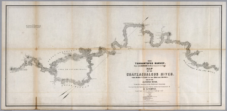
Full Title
1851 Tehuantepec Survey, Major J.G. Barnard. U.S.Engineers, Engineer in Chief. Map of the Coatzacoalcos River from Mina-titlan to the Isla del Suchil and of the Jaltepec River from its junction to the railroad crossing. Surveyed by the Hydrographic party under the command of Wm. G. Temple. Passd. Midn. U.S.N. and Chief Hydroge. Asst. Drawn by Louis R.O. Townsend. Lith. of Sarony & Major 117, Fulton St. New York. Entered ... 1852 by B. Fallon ... in the court of Sn. Desct. of New York. (to accompany) Maps Illustrating The Isthmus of Tehuantepec.
List No
2735.008
Note
Uncolored engraved & lithographic map, folded to 24x15. Relief shown by hachures. Depth shown by soundings. Notes: " The soundings are expressed in feet ..." Includes list of Assistants.
Author
[Barnard, J.G., Bruff, J.]
Full Title
Tehuantepec Survey, Maj. J.G. Barnard. U.S.Engineers, Engineer in Chief. Map of the River Uspanapa to the Playa del Tigre. Made in May 1851 by J.Mc.L. Murphy U.S.N. Hydrographic Assistnt. Lith. of Sarony & Major 117, Fulton St. N.Y. Entered ... 1852 by B. Fallon ... in the court of Sn. Dct. of New York. (insets) Map of the Tancochapa River, from the Hacienda of San Jose to la Isla de Xucuapa. 1851. Map of the Village of Mina-Titlan. Surveyed and drawn by Chas. C. Smith. 1851. (to accompany) Maps Illustrating The Isthmus of Tehuantepec.
List No
2735.009
Note
Uncolored engraved & lithographic map, folded to 24x15, with 2 insets. Relief shown by hachures. Depth shown by soundings in feet. Includes notes, towns, and footprint of major buildings.
Author
[Barnard, J.G., Bruff, J.]
Full Title
Chart of the ports of La Ventosa & Salina Cruz according to the survey made in December 1850 ; for the Tehuantepec Rail Road Company, New Orleans, by their engineer P.E. Trastour. New Orlean October 11th. 1851. Engr. by J. Schedler. Lith. of Sarony & Major. 117 Fulton St. N.Y. Entered ... 1852 by B. Fallon ... in the court of Sn. Desct. of New York. (to accompany) Maps Illustrating The Isthmus of Tehuantepec.
List No
2735.010
Note
Uncolored engraved & lithographic map, folded to 24x15. Relief shown by hachures. Depth shown by soundings. "The soundings on this Chart are expressed in feet and are reduced for low water, December". Includes rivers, towns, and footprint of major buildings.
Author
[Barnard, J.G., Bruff, J.]
Full Title
Chart of the entrance and channel of the Boca-Barra, according to the survey made in November 1850 for the Tehuantepec Rail Road Company of New Orleans by their engineer P.E. Trastour. Lith. of Endicott & Co. N.Y. Entered ... by B. Fallon ... in the court of Southern. Dist. of N. Y. (to accompany) Maps Illustrating The Isthmus of Tehuantepec.
List No
2735.011
Note
Uncolored engraved & lithographic map, folded to 24x15. Depth shown by isolines and soundings. "The soundings on this Chart are expressed in feet and are reduced for low water, November".
1-11 of 11
|