|
REFINE
Browse All : Geology and Atlas Map by Geological Survey of Canada of Cape Breton Island
1-24 of 24
Author
[Fletcher, Hugh., Geological Survey of Canada]
Full Title
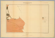
Province of Nova Scotia (Island of Cape Breton). Geological and Natural History Survey of Canada. Alfred R.C. Selwyn, LL.D., F.R.S. &c. Director. 1884. The Burland Lith. Company Montreal. Compiled and drawn by Hugh Fletcher, from plans made by the Admiralty, the Department of Crown Lands, Nova Scotia, and the Geological Survey. To illustrate Reports by Hugh Fletcher, 1879 to 1884. Sheet no. 1.
List No
3997.003
Note
Full color. Shows geologic units, mineral deposits, mineral springs, falls, fishing stations, buildings, land holders names, schools, parish and county boundaries, notes, etc. Relief shown by spot heights. The maps index the various geological reports. Rumsey collection maps backed on linen; protected in new blue cloth folding boards with blue cloth slip case 22 x 16.5 cm., stamped with title "Cape Breton, Nova Scotia, Geological Survey of Canada, 1884" on spine in gold.
Author
[Fletcher, Hugh., Geological Survey of Canada]
Full Title
Province of Nova Scotia (Island of Cape Breton). Geological and Natural History Survey of Canada. Alfred R.C. Selwyn, LL.D., F.R.S. &c. Director. 1884. The Burland Lith. Company Montreal. Compiled and drawn by Hugh Fletcher, from plans made by the Admiralty, the Department of Crown Lands, Nova Scotia, and the Geological Survey. To illustrate Reports by Hugh Fletcher, 1879 to 1884. Sheet no. 2.
List No
3997.004
Note
Full color. Shows geologic units, mineral deposits, mineral springs, falls, fishing stations, buildings, land holders names, schools, parish and county boundaries, notes, etc. Relief shown by spot heights. The maps index the various geological reports. Rumsey collection maps backed on linen; protected in new blue cloth folding boards with blue cloth slip case 22 x 16.5 cm., stamped with title "Cape Breton, Nova Scotia, Geological Survey of Canada, 1884" on spine in gold.
Author
[Fletcher, Hugh., Geological Survey of Canada]
Full Title
Province of Nova Scotia (Island of Cape Breton). Geological and Natural History Survey of Canada. Alfred R.C. Selwyn, LL.D., F.R.S. &c. Director. 1884. The Burland Lith. Company Montreal. Compiled and drawn by Hugh Fletcher, from plans made by the Admiralty, the Department of Crown Lands, Nova Scotia, and the Geological Survey. To illustrate Reports by Hugh Fletcher, 1879 to 1884. Sheet no. 3.
List No
3997.005
Note
Full color. Shows geologic units, mineral deposits, mineral springs, falls, fishing stations, buildings, land holders names, schools, parish and county boundaries, notes, etc. Relief shown by spot heights. The maps index the various geological reports. Rumsey collection maps backed on linen; protected in new blue cloth folding boards with blue cloth slip case 22 x 16.5 cm., stamped with title "Cape Breton, Nova Scotia, Geological Survey of Canada, 1884" on spine in gold.
Author
[Fletcher, Hugh., Geological Survey of Canada]
Full Title
Province of Nova Scotia (Island of Cape Breton). Geological and Natural History Survey of Canada. Alfred R.C. Selwyn, LL.D., F.R.S. &c. Director. 1884. The Burland Lith. Company Montreal. Compiled and drawn by Hugh Fletcher, from plans made by the Admiralty, the Department of Crown Lands, Nova Scotia, and the Geological Survey. To illustrate Reports by Hugh Fletcher, 1879 to 1884. Sheet no. 4.
List No
3997.006
Note
Full color. Shows geologic units, mineral deposits, mineral springs, falls, fishing stations, buildings, land holders names, schools, parish and county boundaries, notes, etc. Relief shown by spot heights. The maps index the various geological reports. Rumsey collection maps backed on linen; protected in new blue cloth folding boards with blue cloth slip case 22 x 16.5 cm., stamped with title "Cape Breton, Nova Scotia, Geological Survey of Canada, 1884" on spine in gold.
Author
[Fletcher, Hugh., Geological Survey of Canada]
Full Title
Province of Nova Scotia (Island of Cape Breton). Geological and Natural History Survey of Canada. Alfred R.C. Selwyn, LL.D., F.R.S. &c. Director. 1884. The Burland Lith. Company Montreal. Compiled and drawn by Hugh Fletcher, from plans made by the Admiralty, the Department of Crown Lands, Nova Scotia, and the Geological Survey. To illustrate Reports by Hugh Fletcher, 1879 to 1884. Sheet no. 5.
List No
3997.007
Note
Full color. Shows geologic units, mineral deposits, mineral springs, falls, fishing stations, buildings, land holders names, schools, parish and county boundaries, notes, etc. Relief shown by spot heights. The maps index the various geological reports. Rumsey collection maps backed on linen; protected in new blue cloth folding boards with blue cloth slip case 22 x 16.5 cm., stamped with title "Cape Breton, Nova Scotia, Geological Survey of Canada, 1884" on spine in gold.
Author
[Fletcher, Hugh., Geological Survey of Canada]
Full Title
Province of Nova Scotia (Island of Cape Breton). Geological and Natural History Survey of Canada. Alfred R.C. Selwyn, LL.D., F.R.S. &c. Director. 1884. The Burland Lith. Company Montreal. Compiled and drawn by Hugh Fletcher, from plans made by the Admiralty, the Department of Crown Lands, Nova Scotia, and the Geological Survey. To illustrate Reports by Hugh Fletcher, 1879 to 1884. Sheet no. 6.
List No
3997.008
Note
Full color. Shows geologic units, mineral deposits, mineral springs, falls, fishing stations, buildings, land holders names, schools, parish and county boundaries, notes, etc. Relief shown by spot heights. The maps index the various geological reports. Rumsey collection maps backed on linen; protected in new blue cloth folding boards with blue cloth slip case 22 x 16.5 cm., stamped with title "Cape Breton, Nova Scotia, Geological Survey of Canada, 1884" on spine in gold.
Author
[Fletcher, Hugh., Geological Survey of Canada]
Full Title
Province of Nova Scotia (Island of Cape Breton). Geological and Natural History Survey of Canada. Alfred R.C. Selwyn, LL.D., F.R.S. &c. Director. 1884. The Burland Lith. Company Montreal. Compiled and drawn by Hugh Fletcher, from plans made by the Admiralty, the Department of Crown Lands, Nova Scotia, and the Geological Survey. To illustrate Reports by Hugh Fletcher, 1879 to 1884. Sheet no. 7.
List No
3997.009
Note
Full color. Shows geologic units, mineral deposits, mineral springs, falls, fishing stations, buildings, land holders names, schools, parish and county boundaries, notes, etc. Relief shown by spot heights. The maps index the various geological reports. Rumsey collection maps backed on linen; protected in new blue cloth folding boards with blue cloth slip case 22 x 16.5 cm., stamped with title "Cape Breton, Nova Scotia, Geological Survey of Canada, 1884" on spine in gold.
Author
[Fletcher, Hugh., Geological Survey of Canada]
Full Title
Province of Nova Scotia (Island of Cape Breton). Geological and Natural History Survey of Canada. Alfred R.C. Selwyn, LL.D., F.R.S. &c. Director. 1884. The Burland Lith. Company Montreal. Compiled and drawn by Hugh Fletcher, from plans made by the Admiralty, the Department of Crown Lands, Nova Scotia, and the Geological Survey. To illustrate Reports by Hugh Fletcher, 1879 to 1884. Sheet no. 8.
List No
3997.010
Note
Full color. Shows geologic units, mineral deposits, mineral springs, falls, fishing stations, buildings, land holders names, schools, parish and county boundaries, notes, etc. Relief shown by spot heights. The maps index the various geological reports. Rumsey collection maps backed on linen; protected in new blue cloth folding boards with blue cloth slip case 22 x 16.5 cm., stamped with title "Cape Breton, Nova Scotia, Geological Survey of Canada, 1884" on spine in gold.
Author
[Fletcher, Hugh., Geological Survey of Canada]
Full Title
Province of Nova Scotia (Island of Cape Breton). Geological and Natural History Survey of Canada. Alfred R.C. Selwyn, LL.D., F.R.S. &c. Director. 1884. The Burland Lith. Company Montreal. Compiled and drawn by Hugh Fletcher, from plans made by the Admiralty, the Department of Crown Lands, Nova Scotia, and the Geological Survey. To illustrate Reports by Hugh Fletcher, 1879 to 1884. Sheet no. 9.
List No
3997.011
Note
Full color. Shows geologic units, mineral deposits, mineral springs, falls, fishing stations, buildings, land holders names, schools, parish and county boundaries, notes, etc. Relief shown by spot heights. The maps index the various geological reports. Rumsey collection maps backed on linen; protected in new blue cloth folding boards with blue cloth slip case 22 x 16.5 cm., stamped with title "Cape Breton, Nova Scotia, Geological Survey of Canada, 1884" on spine in gold.
Author
[Fletcher, Hugh., Geological Survey of Canada]
Full Title
Province of Nova Scotia (Island of Cape Breton). Geological and Natural History Survey of Canada. Alfred R.C. Selwyn, LL.D., F.R.S. &c. Director. 1884. The Burland Lith. Company Montreal. Compiled and drawn by Hugh Fletcher, from plans made by the Admiralty, the Department of Crown Lands, Nova Scotia, and the Geological Survey. To illustrate Reports by Hugh Fletcher, 1879 to 1884. Sheet no. 10.
List No
3997.012
Note
Full color. Shows geologic units, mineral deposits, mineral springs, falls, fishing stations, buildings, land holders names, schools, parish and county boundaries, notes, etc. Relief shown by spot heights. The maps index the various geological reports. Rumsey collection maps backed on linen; protected in new blue cloth folding boards with blue cloth slip case 22 x 16.5 cm., stamped with title "Cape Breton, Nova Scotia, Geological Survey of Canada, 1884" on spine in gold.
Author
[Fletcher, Hugh., Geological Survey of Canada]
Full Title
Province of Nova Scotia (Island of Cape Breton). Geological and Natural History Survey of Canada. Alfred R.C. Selwyn, LL.D., F.R.S. &c. Director. 1884. The Burland Lith. Company Montreal. Compiled and drawn by Hugh Fletcher, from plans made by the Admiralty, the Department of Crown Lands, Nova Scotia, and the Geological Survey. To illustrate Reports by Hugh Fletcher, 1879 to 1884. Sheet no. 11.
List No
3997.013
Note
Full color. Shows geologic units, mineral deposits, mineral springs, falls, fishing stations, buildings, land holders names, schools, parish and county boundaries, notes, etc. Relief shown by spot heights. The maps index the various geological reports. Rumsey collection maps backed on linen; protected in new blue cloth folding boards with blue cloth slip case 22 x 16.5 cm., stamped with title "Cape Breton, Nova Scotia, Geological Survey of Canada, 1884" on spine in gold.
Author
[Fletcher, Hugh., Geological Survey of Canada]
Full Title
Province of Nova Scotia (Island of Cape Breton). Geological and Natural History Survey of Canada. Alfred R.C. Selwyn, LL.D., F.R.S. &c. Director. 1884. The Burland Lith. Company Montreal. Compiled and drawn by Hugh Fletcher, from plans made by the Admiralty, the Department of Crown Lands, Nova Scotia, and the Geological Survey. To illustrate Reports by Hugh Fletcher, 1879 to 1884. Sheet no. 12.
List No
3997.014
Note
Full color. Shows geologic units, mineral deposits, mineral springs, falls, fishing stations, buildings, land holders names, schools, parish and county boundaries, notes, etc. Relief shown by spot heights. The maps index the various geological reports. Rumsey collection maps backed on linen; protected in new blue cloth folding boards with blue cloth slip case 22 x 16.5 cm., stamped with title "Cape Breton, Nova Scotia, Geological Survey of Canada, 1884" on spine in gold.
Author
[Fletcher, Hugh., Geological Survey of Canada]
Full Title
Province of Nova Scotia (Island of Cape Breton). Geological and Natural History Survey of Canada. Alfred R.C. Selwyn, LL.D., F.R.S. &c. Director. 1884. The Burland Lith. Company Montreal. Compiled and drawn by Hugh Fletcher, from plans made by the Admiralty, the Department of Crown Lands, Nova Scotia, and the Geological Survey. To illustrate Reports by Hugh Fletcher, 1879 to 1884. Sheet no. 13.
List No
3997.015
Note
Full color. Shows geologic units, mineral deposits, mineral springs, falls, fishing stations, buildings, land holders names, schools, parish and county boundaries, notes, etc. Relief shown by spot heights. The maps index the various geological reports. Rumsey collection maps backed on linen; protected in new blue cloth folding boards with blue cloth slip case 22 x 16.5 cm., stamped with title "Cape Breton, Nova Scotia, Geological Survey of Canada, 1884" on spine in gold.
Author
[Fletcher, Hugh., Geological Survey of Canada]
Full Title
Province of Nova Scotia (Island of Cape Breton). Geological and Natural History Survey of Canada. Alfred R.C. Selwyn, LL.D., F.R.S. &c. Director. 1884. The Burland Lith. Company Montreal. Compiled and drawn by Hugh Fletcher, from plans made by the Admiralty, the Department of Crown Lands, Nova Scotia, and the Geological Survey. To illustrate Reports by Hugh Fletcher, 1879 to 1884. Sheet no. 14.
List No
3997.016
Note
Full color. Shows geologic units, mineral deposits, mineral springs, falls, fishing stations, buildings, land holders names, schools, parish and county boundaries, notes, etc. Relief shown by spot heights. The maps index the various geological reports. Rumsey collection maps backed on linen; protected in new blue cloth folding boards with blue cloth slip case 22 x 16.5 cm., stamped with title "Cape Breton, Nova Scotia, Geological Survey of Canada, 1884" on spine in gold.
Author
[Fletcher, Hugh., Geological Survey of Canada]
Full Title
Province of Nova Scotia (Island of Cape Breton). Geological and Natural History Survey of Canada. Alfred R.C. Selwyn, LL.D., F.R.S. &c. Director. 1884. The Burland Lith. Company Montreal. Compiled and drawn by Hugh Fletcher, from plans made by the Admiralty, the Department of Crown Lands, Nova Scotia, and the Geological Survey. To illustrate Reports by Hugh Fletcher, 1879 to 1884. Sheet no. 15.
List No
3997.017
Note
Full color. Shows geologic units, mineral deposits, mineral springs, falls, fishing stations, buildings, land holders names, schools, parish and county boundaries, notes, etc. Relief shown by spot heights. The maps index the various geological reports. Rumsey collection maps backed on linen; protected in new blue cloth folding boards with blue cloth slip case 22 x 16.5 cm., stamped with title "Cape Breton, Nova Scotia, Geological Survey of Canada, 1884" on spine in gold.
Author
[Fletcher, Hugh., Geological Survey of Canada]
Full Title
Province of Nova Scotia (Island of Cape Breton). Geological and Natural History Survey of Canada. Alfred R.C. Selwyn, LL.D., F.R.S. &c. Director. 1884. The Burland Lith. Company Montreal. Compiled and drawn by Hugh Fletcher, from plans made by the Admiralty, the Department of Crown Lands, Nova Scotia, and the Geological Survey. To illustrate Reports by Hugh Fletcher, 1879 to 1884. Sheet no. 16.
List No
3997.018
Note
Full color. Shows geologic units, mineral deposits, mineral springs, falls, fishing stations, buildings, land holders names, schools, parish and county boundaries, notes, etc. Relief shown by spot heights. The maps index the various geological reports. Rumsey collection maps backed on linen; protected in new blue cloth folding boards with blue cloth slip case 22 x 16.5 cm., stamped with title "Cape Breton, Nova Scotia, Geological Survey of Canada, 1884" on spine in gold.
Author
[Fletcher, Hugh., Geological Survey of Canada]
Full Title
Province of Nova Scotia (Island of Cape Breton). Geological and Natural History Survey of Canada. Alfred R.C. Selwyn, LL.D., F.R.S. &c. Director. 1884. The Burland Lith. Company Montreal. Compiled and drawn by Hugh Fletcher, from plans made by the Admiralty, the Department of Crown Lands, Nova Scotia, and the Geological Survey. To illustrate Reports by Hugh Fletcher, 1879 to 1884. Sheet no. 17.
List No
3997.019
Note
Full color. Shows geologic units, mineral deposits, mineral springs, falls, fishing stations, buildings, land holders names, schools, parish and county boundaries, notes, etc. Relief shown by spot heights. The maps index the various geological reports. Rumsey collection maps backed on linen; protected in new blue cloth folding boards with blue cloth slip case 22 x 16.5 cm., stamped with title "Cape Breton, Nova Scotia, Geological Survey of Canada, 1884" on spine in gold.
Author
[Fletcher, Hugh., Geological Survey of Canada]
Full Title
Province of Nova Scotia (Island of Cape Breton). Geological and Natural History Survey of Canada. Alfred R.C. Selwyn, LL.D., F.R.S. &c. Director. 1884. The Burland Lith. Company Montreal. Compiled and drawn by Hugh Fletcher, from plans made by the Admiralty, the Department of Crown Lands, Nova Scotia, and the Geological Survey. To illustrate Reports by Hugh Fletcher, 1879 to 1884. Sheet no. 18.
List No
3997.020
Note
Full color. Shows geologic units, mineral deposits, mineral springs, falls, fishing stations, buildings, land holders names, schools, parish and county boundaries, notes, etc. Relief shown by spot heights. The maps index the various geological reports. Rumsey collection maps backed on linen; protected in new blue cloth folding boards with blue cloth slip case 22 x 16.5 cm., stamped with title "Cape Breton, Nova Scotia, Geological Survey of Canada, 1884" on spine in gold.
Author
[Fletcher, Hugh., Geological Survey of Canada]
Full Title
Province of Nova Scotia (Island of Cape Breton). Geological and Natural History Survey of Canada. Alfred R.C. Selwyn, LL.D., F.R.S. &c. Director. 1884. The Burland Lith. Company Montreal. Compiled and drawn by Hugh Fletcher, from plans made by the Admiralty, the Department of Crown Lands, Nova Scotia, and the Geological Survey. To illustrate Reports by Hugh Fletcher, 1879 to 1884. Sheet no. 19.
List No
3997.021
Note
Full color. Shows geologic units, mineral deposits, mineral springs, falls, fishing stations, buildings, land holders names, schools, parish and county boundaries, notes, etc. Relief shown by spot heights. The maps index the various geological reports. Rumsey collection maps backed on linen; protected in new blue cloth folding boards with blue cloth slip case 22 x 16.5 cm., stamped with title "Cape Breton, Nova Scotia, Geological Survey of Canada, 1884" on spine in gold.
Author
[Fletcher, Hugh., Geological Survey of Canada]
Full Title
Province of Nova Scotia (Island of Cape Breton). Geological and Natural History Survey of Canada. Alfred R.C. Selwyn, LL.D., F.R.S. &c. Director. 1884. The Burland Lith. Company Montreal. Compiled and drawn by Hugh Fletcher, from plans made by the Admiralty, the Department of Crown Lands, Nova Scotia, and the Geological Survey. To illustrate Reports by Hugh Fletcher, 1879 to 1884. Sheet no. 20.
List No
3997.022
Note
Full color. Shows geologic units, mineral deposits, mineral springs, falls, fishing stations, buildings, land holders names, schools, parish and county boundaries, notes, etc. Relief shown by spot heights. The maps index the various geological reports. Rumsey collection maps backed on linen; protected in new blue cloth folding boards with blue cloth slip case 22 x 16.5 cm., stamped with title "Cape Breton, Nova Scotia, Geological Survey of Canada, 1884" on spine in gold.
Author
[Fletcher, Hugh., Geological Survey of Canada]
Full Title
Province of Nova Scotia (Island of Cape Breton). Geological and Natural History Survey of Canada. Alfred R.C. Selwyn, LL.D., F.R.S. &c. Director. 1884. The Burland Lith. Company Montreal. Compiled and drawn by Hugh Fletcher, from plans made by the Admiralty, the Department of Crown Lands, Nova Scotia, and the Geological Survey. To illustrate Reports by Hugh Fletcher, 1879 to 1884. Sheet no. 21.
List No
3997.023
Note
Full color. Shows geologic units, mineral deposits, mineral springs, falls, fishing stations, buildings, land holders names, schools, parish and county boundaries, notes, etc. Relief shown by spot heights. The maps index the various geological reports. Rumsey collection maps backed on linen; protected in new blue cloth folding boards with blue cloth slip case 22 x 16.5 cm., stamped with title "Cape Breton, Nova Scotia, Geological Survey of Canada, 1884" on spine in gold.
Author
[Fletcher, Hugh., Geological Survey of Canada]
Full Title
Province of Nova Scotia (Island of Cape Breton). Geological and Natural History Survey of Canada. Alfred R.C. Selwyn, LL.D., F.R.S. &c. Director. 1884. The Burland Lith. Company Montreal. Compiled and drawn by Hugh Fletcher, from plans made by the Admiralty, the Department of Crown Lands, Nova Scotia, and the Geological Survey. To illustrate Reports by Hugh Fletcher, 1879 to 1884. Sheet no. 22.
List No
3997.024
Note
Full color. Shows geologic units, mineral deposits, mineral springs, falls, fishing stations, buildings, land holders names, schools, parish and county boundaries, notes, etc. Relief shown by spot heights. The maps index the various geological reports. Rumsey collection maps backed on linen; protected in new blue cloth folding boards with blue cloth slip case 22 x 16.5 cm., stamped with title "Cape Breton, Nova Scotia, Geological Survey of Canada, 1884" on spine in gold.
Author
[Fletcher, Hugh., Geological Survey of Canada]
Full Title
Province of Nova Scotia (Island of Cape Breton). Geological and Natural History Survey of Canada. Alfred R.C. Selwyn, LL.D., F.R.S. &c. Director. 1884. The Burland Lith. Company Montreal. Compiled and drawn by Hugh Fletcher, from plans made by the Admiralty, the Department of Crown Lands, Nova Scotia, and the Geological Survey. To illustrate Reports by Hugh Fletcher, 1879 to 1884. Sheet no. 23.
List No
3997.025
Note
Full color. Shows geologic units, mineral deposits, mineral springs, falls, fishing stations, buildings, land holders names, schools, parish and county boundaries, notes, etc. Relief shown by spot heights. The maps index the various geological reports. Rumsey collection maps backed on linen; protected in new blue cloth folding boards with blue cloth slip case 22 x 16.5 cm., stamped with title "Cape Breton, Nova Scotia, Geological Survey of Canada, 1884" on spine in gold.
Author
[Fletcher, Hugh., Geological Survey of Canada]
Full Title
Province of Nova Scotia (Island of Cape Breton). Geological and Natural History Survey of Canada. Alfred R.C. Selwyn, LL.D., F.R.S. &c. Director. 1884. The Burland Lith. Company Montreal. Compiled and drawn by Hugh Fletcher, from plans made by the Admiralty, the Department of Crown Lands, Nova Scotia, and the Geological Survey. To illustrate Reports by Hugh Fletcher, 1879 to 1884. Sheet no. 24.
List No
3997.026
Note
Full color. Shows geologic units, mineral deposits, mineral springs, falls, fishing stations, buildings, land holders names, schools, parish and county boundaries, notes, etc. Relief shown by spot heights. The maps index the various geological reports. Rumsey collection maps backed on linen; protected in new blue cloth folding boards with blue cloth slip case 22 x 16.5 cm., stamped with title "Cape Breton, Nova Scotia, Geological Survey of Canada, 1884" on spine in gold.
1-24 of 24
|