|
REFINE
Browse All : Railroad and Pocket Map by G.W. & C.B. Colton. of United States
1-4 of 4
Author
Colton, G.W. & C.B.
Full Title
(Covers to) Colton's New Rail Road & County Map Of The United States, The Canadas &c. Published By G.W. And C.B. Colton, 172 William St. New York. (inset) Colton's Map Of The United States showing the Proposed Railroad Routes To The Pacific Ocean. (inset) Southern Part Of Florida.
List No
4812.001
Note
This is from the same plate as our #4811, but with a different title and the counties colored separately. Extends to the 104th meridian. The date is estimated, based on the similarity to #4811. See our #163 for the edition of 1871. Folded into stamped dark brown cloth covers 16x10.5 with "Colton's Rail Road And County Map Of The United States Canadas &c. G.W. & C.B. Colton. New York." in gilt. prime meridians are Greenwich and Washington D.C.
Author
Colton, G.W. & C.B.
Full Title
Colton's New Rail Road & County Map Of The United States, The Canadas &c. Published By G.W. And C.B. Colton, 172 William St. New York. (inset) Colton's Map Of The United States showing the Proposed Railroad Routes To The Pacific Ocean. (inset) Southern Part Of Florida.
List No
4812.002
Note
This is from the same plate as our #4811, but with a different title and the counties colored separately. Extends to the 104th meridian. The date is estimated, based on the similarity to #4811. See our #163 for the edition of 1871. Folded into stamped dark brown cloth covers 16x10.5 with "Colton's Rail Road And County Map Of The United States Canadas &c. G.W. & C.B. Colton. New York." in gilt. prime meridians are Greenwich and Washington D.C.
Author
Colton, G.W & C.B.
Full Title
(Covers to) Colton's Railroad And Military Map Of The United States, Mexico, The West Indies &c. By J.H. Colton, New York, 1862. Entered ... 1862, by J.H. Colton ... New York.
List No
4858A
Note
Full color map showing the slave, border, and free states by green, yellow and red coloring, explained by the usual Bacon & Co. paste down slip in the lower margin. Nine inset maps show the world, various harbors and battle areas. There are also tables of population for 1850 and 1860. This was #2 in Bacon's London issue six map series of Colton maps depicting the areas of the Civil War. It is derived from a similar Colton map of 1861 (see our #2554) which itself was derived from earlier Johnson maps. Dissected into 32 sections. Folds into brown cloth covers 22x15 with "Price in Sheets 5s. In Case 9s. On Rollers 10s. Colton's Steel Plate Map Of The United States Of America, And the Canadas, Showing the boundaries of the Free, Border Slave, and Seceded States, the Census of 1860, Forts and Fortifications, Area, Exports and Imports, &c. &c." printed on a green paper label.
Author
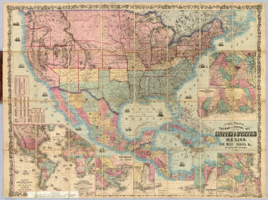
Colton, G.W & C.B.
Full Title
Colton's Railroad And Military Map Of The United States, Mexico, The West Indies &c. Published By G.W. & C.B. Colton, 172 William St. New York. 1865. Printed by Cooper 117 Fulton St. N.Y. (inset) Colton's Map Of The Americas, Africa And A Portion Of Europe, Showing The Atlantic And Part Of The Pacific Oceans. (8 additional inset maps).
List No
4858.001
Note
Full color map showing the slave, border, and free states by green, yellow and red coloring, explained by the usual Bacon & Co. paste down slip in the lower margin. Nine inset maps show the world, various harbors and battle areas. There are also tables of population for 1850 and 1860. This was #2 in Bacon's London issue six map series of Colton maps depicting the areas of the Civil War. It is derived from a similar Colton map of 1861 (see our #2554) which itself was derived from earlier Johnson maps. Dissected into 32 sections. Folds into brown cloth covers 22x15 with "Price in Sheets 5s. In Case 9s. On Rollers 10s. Colton's Steel Plate Map Of The United States Of America, And the Canadas, Showing the boundaries of the Free, Border Slave, and Seceded States, the Census of 1860, Forts and Fortifications, Area, Exports and Imports, &c. &c." printed on a green paper label.
1-4 of 4
|