|
REFINE
Browse All : Railroad by Egloffstein, F.W.
1-20 of 20
Author
[Beckwith, Lieut., Schumann, C.]
Full Title
Weber Lower Canyon. April 5th at 2 P.M. from an island in Weber River; Valley of Great Salt Lake. C. Schumann from F.W. Egloffstein. Selmar Siebert's Engraving & Printing Establishment, Washington, D.C. U.S.P.R.R. Exp. & Surveys 41st Parallel. Expl. by Lieut. Beckwith. Vol. II.
List No
0693.005
Note
View without color. The "Wah-satch Mountains" are in the background.
Author
[Beckwith, Lieut., Hinshelwood, R., Schumann, C.]
Full Title
Second or Sheeprock Canyon of Weber River. April 6th at 1 P.M. View Looking East. C. Schumann from F.W. Egloffstein. R. Hinshelwood. U.S.P.R.R. Exp. & Surveys 41st Parallel. Expl. by Lieut. Beckwith. Vol. II.
List No
0693.006
Note
View uncolored.
Author
[Beckwith, Lieut., Schumann, C.]
Full Title
Porcupine Terrace. Uintah Mountains in the Distance. Camp. April 16th to 17th. C. Schumann from F.W. Egloffstein. Selmar Siebert's Engraving & Printing Establishment, Washington, D.C. U.S.P.R.R. Exp. & Surveys 41st Parallel. Expl. by Lieut. Beckwith. Vol. II.
List No
0693.007
Note
Uncolored engraving shows the Bear River and the Uintah Mountains.
Author
[Beckwith, Lieut., Schumann, C.]
Full Title
Round Prairie From Head of the Same. April 21st at 10 A.M. C. Schumann from F.W. Egloffstein. S.V. Hunt Sc. U.S.P.R.R. Exp. & Surveys 41st Parallel. Expl. by Lieut. Beckwith. Vol. II.
List No
0693.008
Note
Uncolored view includes the Timpanogos River and Canyon.
Author
[Beckwith, Lieut., Schumann, C.]
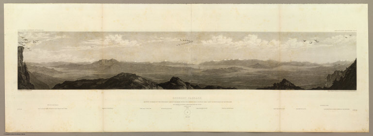
Full Title
Goshoot Passage showing 65 miles of the proposed line of railroad from the desert west of Great Salt Lake to the Humboldt Mountains. May 17th-20th. C. Schumann from F.W. Egloffstein. Selmar Siebert's Engraving & Printing Establishment, Washington, D.C. U.S.P.R.R. Exp. & Surveys 41st Parallel. Expl. by Lieut. Beckwith. Vol. II.
List No
0693.009
Note
Uncolored view includes Don-Don Mountain, Wa-cho-i Mountain, Mo-ko-ga-ri Butte, the Wa-ro-ja Mountains, Franklin valley and lake, and the eastern foot of the Humboldt Mountains.
Author
[Beckwith, Lieut., Schumann, C.]
Full Title
Humboldt Pass. May 22nd at 12 A.M. from high peak east of pass. C. Schumann from F.W. Egloffstein. Selmar Siebert's Engraving & Printing Establishment, Washington, D.C. U.S.P.R.R. Exp. & Surveys 41st Parallel. Expl. by Lieut. Beckwith. Vol. II.
List No
0693.010
Note
View uncolored. Included are the Franklin River, the distant snowy divide of the Humboldt and Columbia Rivers, and the Humboldt valley.
Author
[Beckwith, Lieut., Schumann, C.]
Full Title
Franklin Valley. May 24th at 10 A.M. from a spur of the Humboldt Mountains. C. Schumann from F.W. Egloffstein. Selmar Siebert's Engraving & Printing Establishment, Washington, D.C. U.S.P.R.R. Exp. & Surveys 41st Parallel. Expl. by Lieut. Beckwith. Vol. II.
List No
0693.011
Note
Uncolored view.
Author
[Beckwith, Lieut., Schumann, C.]
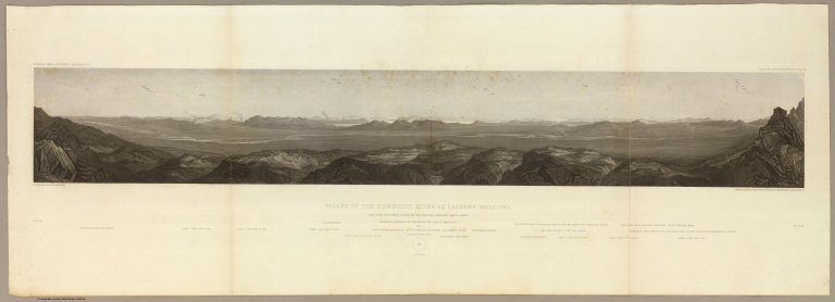
Full Title
Valley of the Humboldt River at Lassen's Meadows. June 9th at 3 P.M. from a peak on the western Humboldt River range. C. Schumann from F.W. Egloffstein. Selmar Siebert's Engraving & Printing Establishment, Washington, D.C. U.S.P.R.R. Exp. & Surveys 41st Parallel. Expl. by Lieut. Beckwith. Vol. II.
List No
0693.012
Note
An uncolored extended view of the Lassen valley. The Sierra Nevadas and the upper Sacramento River can be seen in the background.
Author
[Beckwith, Lieut., Schumann, C.]
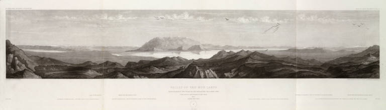
Full Title
Valley of the Mud Lakes showing eighty two miles of the projected rail road line. June 14th at 9 A.M. from Mud Lake peak. C. Schumann from F.W. Egloffstein. Selmar Siebert's Engraving & Printing Establishment, Washington, D.C. U.S.P.R.R. Exp. & Surveys 41st Parallel. Expl. by Lieut. Beckwith. Vol. II.
List No
0693.013
Note
Uncolored view including the eastern base of the Sierra Nevadas and the Oregon road entering the Sierra Nevada.
Author
[Beckwith, Lieut., Schumann, C.]
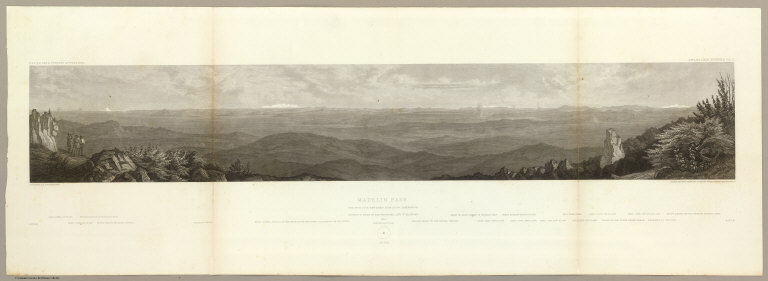
Full Title
Madelin Pass. June 19th at 2 P.M. view taken from Mount Observation. C. Schumann from F.W. Egloffstein. Selmar Siebert's Engraving & Printing Establishment, Washington, D.C. U.S.P.R.R. Exp. & Surveys 41st Parallel. Expl. by Lieut. Beckwith. Vol. II.
List No
0693.014
Note
Uncolored view showing the stretch looking east from Mt. Shasta to the Sierras west of Pyramid Lake.
Author
[Beckwith, Lieut., Schumann, C.]
Full Title
West End of Madelin Pass. June 26th at 8 A.M. from a peak overlooking Madelin Creek. C. Schumann from F.W. Egloffstein. Selmar Siebert's Engraving & Printing Establishment, Washington, D.C. U.S.P.R.R. Exp. & Surveys 41st Parallel. Expl. by Lieut. Beckwith. Vol. II.
List No
0693.015
Note
Uncolored view to the north showing the Sacramento River descending through the Round Valley. Mt. Shasta is shown in the background.
Author
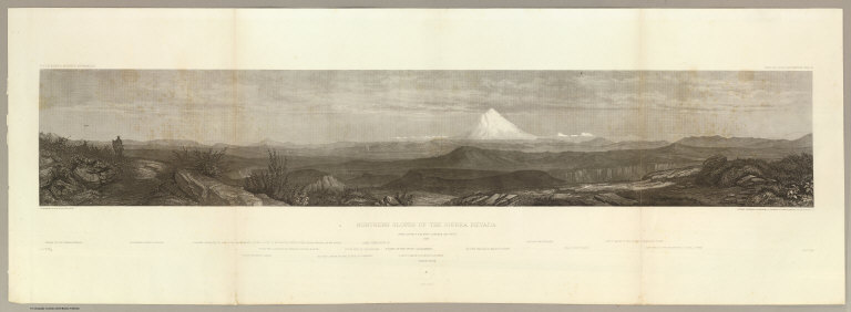
[Beckwith, Lieut., Schumann, C.]
Full Title
Northern Slopes of the Sierra Nevada. June 30th at 9 A.M. view towards the West 1854. C. Schumann from F.W. Egloffstein. Selmar Siebert's Engraving & Printing Establishment, Washington, D.C. U.S.P.R.R. Exp. & Surveys 41st Parallel. Expl. by Lieut. Beckwith. Vol. II.
List No
0693.016
Note
View uncolored. The center of the view is dominated by Mt. Shasta, 50 miles in the distance. The view is looking to the west with the Coast Range 100 miles in the distance.
Author
[Beckwith, Lieut., Schumann, C.]
Full Title
Portion of the main mountain passage of the upper Sacramento or Pitt River. July 20th at 1 P.M. 25 miles south of Mt. Shasta. C. Schumann from F.W. Egloffstein. Selmar Siebert's Engraving & Printing Establishment, Washington, D.C. U.S.P.R.R. Exp. & Surveys 41st Parallel. Expl. by Lieut. Beckwith. Vol. II.
List No
0693.017
Note
Uncolored view looking to Mt. Shasta in the north.
Author
Beckwith, E.G.
Full Title
From the Valley of Green River to the Great Salt Lake; from Explorations and Surveys made under the direction of the Hon. Jefferson Davis Secretary of War by Capt. E.G. Beckwith, 3d. Artillery. F.W. Egloffstein, Topographer for the Route. 1855. Explorations and surveys for a railroad route from the Mississippi River to the Pacific Ocean. War Department. Route near the 41st Parallel. Map No. 1. Selmar Siebert's Engraving & Printing Establishment. Washington, D.C.
List No
0693.028
Note
Detailed map from just above the 38th parallel up to the 42nd parallel. Uncolored.
Author
Beckwith, E.G.
Full Title
From Great Salt Lake to the Humboldt Mountains; from Explorations and Surveys made under the direction of the Hon. Jefferson Davis Secretary of War by Capt. E.G. Beckwith, 3d. Artillery. F.W. Egloffstein, Topographer for the Route. 1855. Explorations and surveys for a railroad route from the Mississippi River to the Pacific Ocean. War Department. Route near the 41st Parallel. Map No. 2. Selmar Siebert's Engraving & Printing Establishment. Washington, D.C.
List No
0693.029
Note
Uncolored map includes the area from the Great Salt Lake to Humboldt pass. Path clearly laid out for the proposed railway route.
Author
Beckwith, E.G.
Full Title
From the Humboldt Mountains to the Mud Lakes; from Explorations and Surveys made under the direction of the Hon. Jefferson Davis Secretary of War by Capt. E.G. Beckwith, 3d. Artillery. F.W. Egloffstein, Topographer for the Route. 1855. Explorations and surveys for a railroad route from the Mississippi River to the Pacific Ocean. War Department. Route near the 41st Parallel. Map No. 3. Selmar Siebert's Engraving & Printing Establishment. Washington, D.C.
List No
0693.030
Note
Uncolored map follows the Humboldt River across present-day Nevada to the far edge of Pyramid Lake. Proposed railway line clearly shown.
Author
Beckwith, E.G.
Full Title
From the Mud Lakes to the Pacific Ocean; from Explorations and Surveys made under the direction of the Hon. Jefferson Davis Secretary of War by Capt. E.G. Beckwith, 3d. Artillery. F.W. Egloffstein, Topographer for the Route. 1855. Explorations and surveys for a railroad route from the Mississippi River to the Pacific Ocean. War Department. Route near the 41st Parallel. Map No. 4. Selmar Siebert's Engraving & Printing Establishment. Washington, D.C.
List No
0693.031
Note
Uncolored map drawn in detail from Pyramid Lake in present-day Nevada to Mt. Shasta. The rest of the map is in sketchy detail.
Author
Gunnison, J.W.
Full Title
From the Mouth of Trap Creek to the Santa Fe Crossing; from Explorations and Surveys made under the direction of the Hon. Jefferson Davis Secretary of War by Capt. J.W. Gunnison. Topl. Engrs. assisted by Capt. E.G. Beckwith 3d Artillery. R.H. Kern Topographer in the field. Map made under the supervision of Capt. E.G. Beckwith 3d Artillery by F.W. Egloffstein, Topographer for the Route. 1855. Explorations and surveys for a railroad route from the Mississippi River to the Pacific Ocean. War Department. Route near the 38th & 39th Parallels. Map No. 2. Engr. by Selmar Siebert.
List No
0693.034
Note
Uncolored map stretching from Uniontown (Kansas) and along the Santa Fe trail to Ft. Atkinson on the Arkansas River.
Author
Gunnison, J.W.
Full Title
From the Santa Fe Crossing to the Coo-che-to-pa Pass; from Explorations and Surveys made under the direction of the Hon. Jefferson Davis Secretary of War by Capt. J.W. Gunnison. Topl. Engrs. assisted by Capt. E.G. Beckwith 3d Artillery. R.H. Kern Topographer in the field. Map made under the supervision of Capt. E.G. Beckwith 3d Artillery by F.W. Egloffstein, Topographer for the Route. 1855. Explorations and surveys for a railroad route from the Mississippi River to the Pacific Ocean. War Department. Route near the 38th & 39th Parallels. Map No. 3. Engr. by Selmar Siebert.
List No
0693.035
Note
Uncolored map covers the area from Elk Island in the Arkansas River (Kansas) to Sahwatch Creek (Colorado). Pueblo, Colorado and Pike's Peak are shown. Settlements can be seen running south from the Sangre de Cristo Mountains to Taos (New Mexico).
Author
Gunnison, J.W.
Full Title
From the Coo-che-to-pa Pass to the Wahsatch Mountains; from Explorations and Surveys made under the direction of the Hon. Jefferson Davis Secretary of War by Capt. J.W. Gunnison. Topl. Engrs. assisted by Capt. E.G. Beckwith 3d Artillery. R.H. Kern Topographer in the field. Map made under the supervision of Capt. E.G. Beckwith 3d Artillery by F.W. Egloffstein, Topographer for the Route. 1855. Explorations and surveys for a railroad route from the Mississippi River to the Pacific Ocean. War Department. Route near the 38th & 39th Parallels. Map No. 4. Engr. by Selmar Siebert.
List No
0693.036
Note
Map spans the region from Sahwatch Creek (Colorado) in the east, through the Black Canyon of the Gunnison, and then along the Colorado River into Utah.
1-20 of 20
|