|
REFINE
Browse All : Book Map by Egloffstein, F.W.
1-12 of 12
Author
Ives, J.C.
Full Title
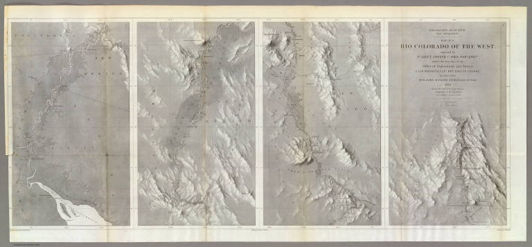
Explorations and Surveys. War Department. Map No. 1. Rio Colorado of the West, explored by 1st Lieut. Joseph C. Ives, Topl. Engrs. under the direction of the Office of Explorations and Surveys. A.A. Humphreys, Capt. Topl. Engrs. in Charge, by order of the Hon. John B. Floyd, Secretary of War. 1858. Drawn by Frhr. F.W.v. Egloffstein. Topographer to the Expedition. Topography by Frhr. F.W.v. Egloffstein. Ruling by Samuel Sartain. Lettering by F. Courtenay.
List No
0341.001
Note
Uncolored map in four parts across the page with the title on the far right map, with the maps reading from right to left. The detail of the map is superb, and shows the course of the Colorado River from its headwaters to the Gulf of California.
Author
Ives, J.C.
Full Title
Explorations and Surveys. War Department. Map No. 2. Rio Colorado of the West, explored by 1st Lieut. Joseph C. Ives, Topl. Engrs. under the direction of the Office of Explorations and Surveys. A.A. Humphreys, Capt. Topl. Engrs. in Charge, by order of the Hon. John B. Floyd, Secretary of War. 1858. Drawn by Frhr. F.W.v. Egloffstein. Topographer to the Expedition. Topography by Frhr. F.W.v. Egloffstein. Ruling by Samuel Sartain. Lettering by F. Courtenay.
List No
0341.002
Note
Uncolored map showing the Grand Canyon in superb detail. The "line of exploration" and camps are shown.
Author
Ives, J.C.
Full Title
Geological Map No. 1. Prepared by J.S. Newberry, M.D. Geologist to the Expedition. Explorations and Surveys. War Department. Map No. 1. Rio Colorado of the West, explored by 1st Lieut. Joseph C. Ives, Topl. Engrs. under the direction of the Office of Explorations and Surveys. A.A. Humphreys, Capt. Topl. Engrs. in Charge, by order of the Hon. John B. Floyd, Secretary of War. 1858. Drawn by Frhr. F.W.v. Egloffstein. Topographer to the Expedition. Topography by Frhr. F.W.v. Egloffstein. Ruling by Samuel Sartain. Lettering by F. Courtenay.
List No
0341.003
Note
Color washed map in four parts across the page with the title on the far right map, with the maps reading from right to left. The detail of the map is superb, and shows the course of the Colorado River from its headwaters to the Gulf of California.
Author
Ives, J.C.
Full Title
Geological Map No. 2. Prepared by J.S. Newberry, M.D. Geologist to the Expedition. Explorations and Surveys. War Department. Map No. 1. Rio Colorado of the West, explored by 1st Lieut. Joseph C. Ives, Topl. Engrs. under the direction of the Office of Explorations and Surveys. A.A. Humphreys, Capt. Topl. Engrs. in Charge, by order of the Hon. John B. Floyd, Secretary of War. 1858. Drawn by Frhr. F.W.v. Egloffstein. Topographer to the Expedition. Topography by Frhr. F.W.v. Egloffstein. Ruling by Samuel Sartain. Lettering by F. Courtenay.
List No
0341.004
Note
Color washed map showing the Grand Canyon in superb detail with geological information included. A key is added below the map. The "line of exploration" and camps are shown.
Author
Beckwith, E.G.
Full Title
From the Valley of Green River to the Great Salt Lake; from Explorations and Surveys made under the direction of the Hon. Jefferson Davis Secretary of War by Capt. E.G. Beckwith, 3d. Artillery. F.W. Egloffstein, Topographer for the Route. 1855. Explorations and surveys for a railroad route from the Mississippi River to the Pacific Ocean. War Department. Route near the 41st Parallel. Map No. 1. Selmar Siebert's Engraving & Printing Establishment. Washington, D.C.
List No
0693.028
Note
Detailed map from just above the 38th parallel up to the 42nd parallel. Uncolored.
Author
Beckwith, E.G.
Full Title
From Great Salt Lake to the Humboldt Mountains; from Explorations and Surveys made under the direction of the Hon. Jefferson Davis Secretary of War by Capt. E.G. Beckwith, 3d. Artillery. F.W. Egloffstein, Topographer for the Route. 1855. Explorations and surveys for a railroad route from the Mississippi River to the Pacific Ocean. War Department. Route near the 41st Parallel. Map No. 2. Selmar Siebert's Engraving & Printing Establishment. Washington, D.C.
List No
0693.029
Note
Uncolored map includes the area from the Great Salt Lake to Humboldt pass. Path clearly laid out for the proposed railway route.
Author
Beckwith, E.G.
Full Title
From the Humboldt Mountains to the Mud Lakes; from Explorations and Surveys made under the direction of the Hon. Jefferson Davis Secretary of War by Capt. E.G. Beckwith, 3d. Artillery. F.W. Egloffstein, Topographer for the Route. 1855. Explorations and surveys for a railroad route from the Mississippi River to the Pacific Ocean. War Department. Route near the 41st Parallel. Map No. 3. Selmar Siebert's Engraving & Printing Establishment. Washington, D.C.
List No
0693.030
Note
Uncolored map follows the Humboldt River across present-day Nevada to the far edge of Pyramid Lake. Proposed railway line clearly shown.
Author
Beckwith, E.G.
Full Title
From the Mud Lakes to the Pacific Ocean; from Explorations and Surveys made under the direction of the Hon. Jefferson Davis Secretary of War by Capt. E.G. Beckwith, 3d. Artillery. F.W. Egloffstein, Topographer for the Route. 1855. Explorations and surveys for a railroad route from the Mississippi River to the Pacific Ocean. War Department. Route near the 41st Parallel. Map No. 4. Selmar Siebert's Engraving & Printing Establishment. Washington, D.C.
List No
0693.031
Note
Uncolored map drawn in detail from Pyramid Lake in present-day Nevada to Mt. Shasta. The rest of the map is in sketchy detail.
Author
Gunnison, J.W.
Full Title
From the Mouth of Trap Creek to the Santa Fe Crossing; from Explorations and Surveys made under the direction of the Hon. Jefferson Davis Secretary of War by Capt. J.W. Gunnison. Topl. Engrs. assisted by Capt. E.G. Beckwith 3d Artillery. R.H. Kern Topographer in the field. Map made under the supervision of Capt. E.G. Beckwith 3d Artillery by F.W. Egloffstein, Topographer for the Route. 1855. Explorations and surveys for a railroad route from the Mississippi River to the Pacific Ocean. War Department. Route near the 38th & 39th Parallels. Map No. 2. Engr. by Selmar Siebert.
List No
0693.034
Note
Uncolored map stretching from Uniontown (Kansas) and along the Santa Fe trail to Ft. Atkinson on the Arkansas River.
Author
Gunnison, J.W.
Full Title
From the Santa Fe Crossing to the Coo-che-to-pa Pass; from Explorations and Surveys made under the direction of the Hon. Jefferson Davis Secretary of War by Capt. J.W. Gunnison. Topl. Engrs. assisted by Capt. E.G. Beckwith 3d Artillery. R.H. Kern Topographer in the field. Map made under the supervision of Capt. E.G. Beckwith 3d Artillery by F.W. Egloffstein, Topographer for the Route. 1855. Explorations and surveys for a railroad route from the Mississippi River to the Pacific Ocean. War Department. Route near the 38th & 39th Parallels. Map No. 3. Engr. by Selmar Siebert.
List No
0693.035
Note
Uncolored map covers the area from Elk Island in the Arkansas River (Kansas) to Sahwatch Creek (Colorado). Pueblo, Colorado and Pike's Peak are shown. Settlements can be seen running south from the Sangre de Cristo Mountains to Taos (New Mexico).
Author
Gunnison, J.W.
Full Title
From the Coo-che-to-pa Pass to the Wahsatch Mountains; from Explorations and Surveys made under the direction of the Hon. Jefferson Davis Secretary of War by Capt. J.W. Gunnison. Topl. Engrs. assisted by Capt. E.G. Beckwith 3d Artillery. R.H. Kern Topographer in the field. Map made under the supervision of Capt. E.G. Beckwith 3d Artillery by F.W. Egloffstein, Topographer for the Route. 1855. Explorations and surveys for a railroad route from the Mississippi River to the Pacific Ocean. War Department. Route near the 38th & 39th Parallels. Map No. 4. Engr. by Selmar Siebert.
List No
0693.036
Note
Map spans the region from Sahwatch Creek (Colorado) in the east, through the Black Canyon of the Gunnison, and then along the Colorado River into Utah.
Author
[Macomb, J.N., Egloffstein, F.W.]
Full Title
Map of Exploration and Surveys in New Mexico and Utah made under the direction of the Secretary of War by Capt. J.N. Macomb Topl. Engrs. assisted by C.H. Dimmock, C. Engr. 1860. Lettering by John L. Hazzard. Ruling by Samuel Sartain. Constructed and Engraved by Baron F.W. Von Egloffstein.
List No
2699.002
Note
Has the Egloffstein map, which Wheat calls "one of the most beautiful maps ever published by the Army." Egloffstein made his map in 1864. The publication of the map and the report were delayed by the Civil War. Map entitled, "Map of Explorations and Surveys in New Mexico and Utah made under the direction of the Secretary of War by Capt. J.N. Macomb Topl. Engrs. assisted by C.H. Dimmock, C. Engr. 1860." Bound book with cloth covers with title embossed on spine.
1-12 of 12
|