|
REFINE
Browse All : Images by E. Jones
1-15 of 15
Author
Arrowsmith, A.
Full Title
(Composite Map) Map of South Italy and Adjacent Coasts.
List No
7843.005
Author
Arrowsmith, Aaron
Full Title
(Top Sheet to) To His Royal Highness the Duke of Cambridge, K. G. &c. This Map of the Physical Divisions of Germany, Exhibiting the Post Roads, Canals &c, Constructed from Original Materials, Is with Permission Most humbly Inscribed by His Royal Highness's Faithful & most Devoted Servant, A. Arrowsmith. J. Rowe scrt. & scrulpt. London Published 2nd. Octr. 1812 by A. Arrowsmith Hydrographer to H.R.H. the Prince of Wales, No. 10 Soho Square. Additions & Corrections to Sept. 1816.
List No
6706.001
Note
This map was first issued in 1812 (see our 6712.000), this 1816 edition has been updated to show the new boundaries resulting from the Treaty of Paris of November 1815. Many areas along the boundary of Germany and France have been changed. "Arrowsmith was soon recognized in Britain and abroad as a cartographer of outstanding accuracy and skill and was accorded the title of hydrographer to the prince regent about 1810 and that of hydrographer to the king in 1820. His maps were in great demand by official bodies such as the Admiralty and, more surprisingly given their great size and hence cost, with the public as well. In 1807 he published his map of Scotland, based on the military survey of Scotland of 1745-55 and of particular interest for the accompanying Memoir (1809) in which he described how he constructed the map. His last major work was his map of India (1822). He engraved and printed many of his own maps and all of those produced in his shop (at 10 Soho Square from 1814) were noted for the functional beauty and simplicity with which they were engraved" (Elizabeth Baigent for DNB).
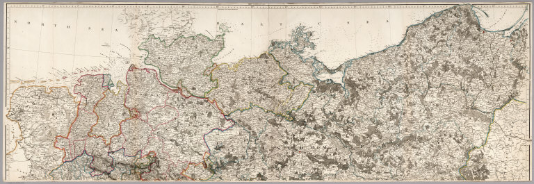
Author
Arrowsmith, Aaron
Full Title
(Middle Sheet to) To His Royal Highness the Duke of Cambridge, K. G. &c. This Map of the Physical Divisions of Germany, Exhibiting the Post Roads, Canals &c, Constructed from Original Materials, Is with Permission Most humbly Inscribed by His Royal Highness's Faithful & most Devoted Servant, A. Arrowsmith. J. Rowe scrt. & scrulpt. London Published 2nd. Octr. 1812 by A. Arrowsmith Hydrographer to H.R.H. the Prince of Wales, No. 10 Soho Square. Additions & Corrections to Sept. 1816.
List No
6706.002
Note
This map was first issued in 1812 (see our 6712.000), this 1816 edition has been updated to show the new boundaries resulting from the Treaty of Paris of November 1815. Many areas along the boundary of Germany and France have been changed. "Arrowsmith was soon recognized in Britain and abroad as a cartographer of outstanding accuracy and skill and was accorded the title of hydrographer to the prince regent about 1810 and that of hydrographer to the king in 1820. His maps were in great demand by official bodies such as the Admiralty and, more surprisingly given their great size and hence cost, with the public as well. In 1807 he published his map of Scotland, based on the military survey of Scotland of 1745-55 and of particular interest for the accompanying Memoir (1809) in which he described how he constructed the map. His last major work was his map of India (1822). He engraved and printed many of his own maps and all of those produced in his shop (at 10 Soho Square from 1814) were noted for the functional beauty and simplicity with which they were engraved" (Elizabeth Baigent for DNB).
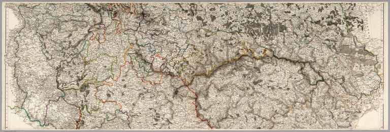
Author
Arrowsmith, Aaron
Full Title
(Bottom Sheet to) To His Royal Highness the Duke of Cambridge, K. G. &c. This Map of the Physical Divisions of Germany, Exhibiting the Post Roads, Canals &c, Constructed from Original Materials, Is with Permission Most humbly Inscribed by His Royal Highness's Faithful & most Devoted Servant, A. Arrowsmith. J. Rowe scrt. & scrulpt. London Published 2nd. Octr. 1812 by A. Arrowsmith Hydrographer to H.R.H. the Prince of Wales, No. 10 Soho Square. Additions & Corrections to Sept. 1816.
List No
6706.003
Note
Two flaps added at the bottom of the sheet extend the map to parts of northern Italy. This map was first issued in 1812 (see our 6712.000), this 1816 edition has been updated to show the new boundaries resulting from the Treaty of Paris of November 1815. Many areas along the boundary of Germany and France have been changed. "Arrowsmith was soon recognized in Britain and abroad as a cartographer of outstanding accuracy and skill and was accorded the title of hydrographer to the prince regent about 1810 and that of hydrographer to the king in 1820. His maps were in great demand by official bodies such as the Admiralty and, more surprisingly given their great size and hence cost, with the public as well. In 1807 he published his map of Scotland, based on the military survey of Scotland of 1745-55 and of particular interest for the accompanying Memoir (1809) in which he described how he constructed the map. His last major work was his map of India (1822). He engraved and printed many of his own maps and all of those produced in his shop (at 10 Soho Square from 1814) were noted for the functional beauty and simplicity with which they were engraved" (Elizabeth Baigent for DNB).
Author
Arrowsmith, Aaron
Full Title
(Composite Map of) To His Royal Highness the Duke of Cambridge, K. G. &c. This Map of the Physical Divisions of Germany, Exhibiting the Post Roads, Canals &c, Constructed from Original Materials, Is with Permission Most humbly Inscribed by His Royal Highness's Faithful & most Devoted Servant, A. Arrowsmith. J. Rowe scrt. & scrulpt. London Published 2nd. Octr. 1812 by A. Arrowsmith Hydrographer to H.R.H. the Prince of Wales, No. 10 Soho Square. Additions & Corrections to Sept. 1816.
List No
6706.004
Note
This map was first issued in 1812 (see our 6712.000), this 1816 edition has been updated to show the new boundaries resulting from the Treaty of Paris of November 1815. Many areas along the boundary of Germany and France have been changed. "Arrowsmith was soon recognized in Britain and abroad as a cartographer of outstanding accuracy and skill and was accorded the title of hydrographer to the prince regent about 1810 and that of hydrographer to the king in 1820. His maps were in great demand by official bodies such as the Admiralty and, more surprisingly given their great size and hence cost, with the public as well. In 1807 he published his map of Scotland, based on the military survey of Scotland of 1745-55 and of particular interest for the accompanying Memoir (1809) in which he described how he constructed the map. His last major work was his map of India (1822). He engraved and printed many of his own maps and all of those produced in his shop (at 10 Soho Square from 1814) were noted for the functional beauty and simplicity with which they were engraved" (Elizabeth Baigent for DNB).
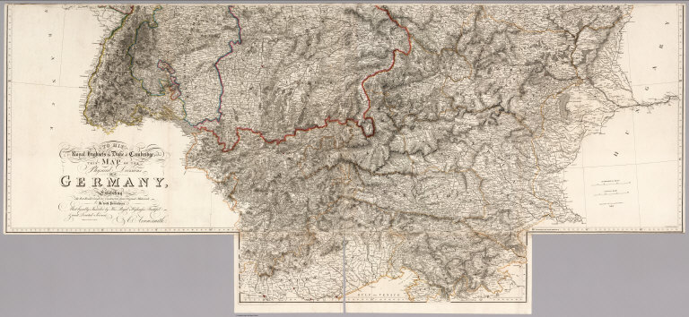
Author
Arrowsmith, Aaron
Full Title
(Covers to) To His Royal Highness the Duke of Cambridge, K. G. &c. This Map of the Physical Divisions of Germany, Exhibiting the Post Roads, Canals &c, Constructed from Original Materials, Is with Permission Most humbly Inscribed by His Royal Highness's Faithful & most Devoted Servant, A. Arrowsmith. J. Rowe scrt. & scrulpt. London Published 2nd. Octr. 1812 by A. Arrowsmith Hydrographer to H.R.H. the Prince of Wales, No. 10 Soho Square. Engraved by E. Jones.
List No
6712.001
Note
This is the first issue of this map; a second edition was published in 1816 (see our 6706.000), which was updated to show the new boundaries resulting from the Treaty of Paris of November 1815. This 1812 edition has the pre treaty boundaries, which are most evident along the boundary of Germany and France. "Arrowsmith was soon recognized in Britain and abroad as a cartographer of outstanding accuracy and skill and was accorded the title of hydrographer to the prince regent about 1810 and that of hydrographer to the king in 1820. His maps were in great demand by official bodies such as the Admiralty and, more surprisingly given their great size and hence cost, with the public as well. In 1807 he published his map of Scotland, based on the military survey of Scotland of 1745-55 and of particular interest for the accompanying Memoir (1809) in which he described how he constructed the map. His last major work was his map of India (1822). He engraved and printed many of his own maps and all of those produced in his shop (at 10 Soho Square from 1814) were noted for the functional beauty and simplicity with which they were engraved" (Elizabeth Baigent for DNB). Two flaps extend the map to northern Italy.
Author
Arrowsmith, Aaron
Full Title
(Lower Left) To His Royal Highness the Duke of Cambridge, K. G. &c. This Map of the Physical Divisions of Germany, Exhibiting the Post Roads, Canals &c, Constructed from Original Materials, Is with Permission Most humbly Inscribed by His Royal Highness's Faithful & most Devoted Servant, A. Arrowsmith. J. Rowe scrt. & scrulpt. London Published 2nd. Octr. 1812 by A. Arrowsmith Hydrographer to H.R.H. the Prince of Wales, No. 10 Soho Square. Engraved by E. Jones.
List No
6712.002
Note
This is the first issue of this map; a second edition was published in 1816 (see our 6706.000), which was updated to show the new boundaries resulting from the Treaty of Paris of November 1815. This 1812 edition has the pre treaty boundaries, which are most evident along the boundary of Germany and France. "Arrowsmith was soon recognized in Britain and abroad as a cartographer of outstanding accuracy and skill and was accorded the title of hydrographer to the prince regent about 1810 and that of hydrographer to the king in 1820. His maps were in great demand by official bodies such as the Admiralty and, more surprisingly given their great size and hence cost, with the public as well. In 1807 he published his map of Scotland, based on the military survey of Scotland of 1745-55 and of particular interest for the accompanying Memoir (1809) in which he described how he constructed the map. His last major work was his map of India (1822). He engraved and printed many of his own maps and all of those produced in his shop (at 10 Soho Square from 1814) were noted for the functional beauty and simplicity with which they were engraved" (Elizabeth Baigent for DNB). Two flaps extend the map to northern Italy.
Author
Arrowsmith, Aaron
Full Title
(Lower Right) To His Royal Highness the Duke of Cambridge, K. G. &c. This Map of the Physical Divisions of Germany, Exhibiting the Post Roads, Canals &c, Constructed from Original Materials, Is with Permission Most humbly Inscribed by His Royal Highness's Faithful & most Devoted Servant, A. Arrowsmith. J. Rowe scrt. & scrulpt. London Published 2nd. Octr. 1812 by A. Arrowsmith Hydrographer to H.R.H. the Prince of Wales, No. 10 Soho Square. Engraved by E. Jones.
List No
6712.003
Note
This is the first issue of this map; a second edition was published in 1816 (see our 6706.000), which was updated to show the new boundaries resulting from the Treaty of Paris of November 1815. This 1812 edition has the pre treaty boundaries, which are most evident along the boundary of Germany and France. "Arrowsmith was soon recognized in Britain and abroad as a cartographer of outstanding accuracy and skill and was accorded the title of hydrographer to the prince regent about 1810 and that of hydrographer to the king in 1820. His maps were in great demand by official bodies such as the Admiralty and, more surprisingly given their great size and hence cost, with the public as well. In 1807 he published his map of Scotland, based on the military survey of Scotland of 1745-55 and of particular interest for the accompanying Memoir (1809) in which he described how he constructed the map. His last major work was his map of India (1822). He engraved and printed many of his own maps and all of those produced in his shop (at 10 Soho Square from 1814) were noted for the functional beauty and simplicity with which they were engraved" (Elizabeth Baigent for DNB). Two flaps extend the map to northern Italy.
Author
Arrowsmith, Aaron
Full Title
(Upper Left) To His Royal Highness the Duke of Cambridge, K. G. &c. This Map of the Physical Divisions of Germany, Exhibiting the Post Roads, Canals &c, Constructed from Original Materials, Is with Permission Most humbly Inscribed by His Royal Highness's Faithful & most Devoted Servant, A. Arrowsmith. J. Rowe scrt. & scrulpt. London Published 2nd. Octr. 1812 by A. Arrowsmith Hydrographer to H.R.H. the Prince of Wales, No. 10 Soho Square. Engraved by E. Jones.
List No
6712.004
Note
This is the first issue of this map; a second edition was published in 1816 (see our 6706.000), which was updated to show the new boundaries resulting from the Treaty of Paris of November 1815. This 1812 edition has the pre treaty boundaries, which are most evident along the boundary of Germany and France. "Arrowsmith was soon recognized in Britain and abroad as a cartographer of outstanding accuracy and skill and was accorded the title of hydrographer to the prince regent about 1810 and that of hydrographer to the king in 1820. His maps were in great demand by official bodies such as the Admiralty and, more surprisingly given their great size and hence cost, with the public as well. In 1807 he published his map of Scotland, based on the military survey of Scotland of 1745-55 and of particular interest for the accompanying Memoir (1809) in which he described how he constructed the map. His last major work was his map of India (1822). He engraved and printed many of his own maps and all of those produced in his shop (at 10 Soho Square from 1814) were noted for the functional beauty and simplicity with which they were engraved" (Elizabeth Baigent for DNB). Two flaps extend the map to northern Italy.
Author
Arrowsmith, Aaron
Full Title
(Upper Right) To His Royal Highness the Duke of Cambridge, K. G. &c. This Map of the Physical Divisions of Germany, Exhibiting the Post Roads, Canals &c, Constructed from Original Materials, Is with Permission Most humbly Inscribed by His Royal Highness's Faithful & most Devoted Servant, A. Arrowsmith. J. Rowe scrt. & scrulpt. London Published 2nd. Octr. 1812 by A. Arrowsmith Hydrographer to H.R.H. the Prince of Wales, No. 10 Soho Square. Engraved by E. Jones.
List No
6712.005
Note
This is the first issue of this map; a second edition was published in 1816 (see our 6706.000), which was updated to show the new boundaries resulting from the Treaty of Paris of November 1815. This 1812 edition has the pre treaty boundaries, which are most evident along the boundary of Germany and France. "Arrowsmith was soon recognized in Britain and abroad as a cartographer of outstanding accuracy and skill and was accorded the title of hydrographer to the prince regent about 1810 and that of hydrographer to the king in 1820. His maps were in great demand by official bodies such as the Admiralty and, more surprisingly given their great size and hence cost, with the public as well. In 1807 he published his map of Scotland, based on the military survey of Scotland of 1745-55 and of particular interest for the accompanying Memoir (1809) in which he described how he constructed the map. His last major work was his map of India (1822). He engraved and printed many of his own maps and all of those produced in his shop (at 10 Soho Square from 1814) were noted for the functional beauty and simplicity with which they were engraved" (Elizabeth Baigent for DNB). Two flaps extend the map to northern Italy.
Author
Arrowsmith, Aaron
Full Title
(Composite Map) To His Royal Highness the Duke of Cambridge, K. G. &c. This Map of the Physical Divisions of Germany, Exhibiting the Post Roads, Canals &c, Constructed from Original Materials, Is with Permission Most humbly Inscribed by His Royal Highness's Faithful & most Devoted Servant, A. Arrowsmith. J. Rowe scrt. & scrulpt. London Published 2nd. Octr. 1812 by A. Arrowsmith Hydrographer to H.R.H. the Prince of Wales, No. 10 Soho Square. Engraved by E. Jones.
List No
6712.006
Note
This is the first issue of this map; a second edition was published in 1816 (see our 6706.000), which was updated to show the new boundaries resulting from the Treaty of Paris of November 1815. This 1812 edition has the pre treaty boundaries, which are most evident along the boundary of Germany and France. "Arrowsmith was soon recognized in Britain and abroad as a cartographer of outstanding accuracy and skill and was accorded the title of hydrographer to the prince regent about 1810 and that of hydrographer to the king in 1820. His maps were in great demand by official bodies such as the Admiralty and, more surprisingly given their great size and hence cost, with the public as well. In 1807 he published his map of Scotland, based on the military survey of Scotland of 1745-55 and of particular interest for the accompanying Memoir (1809) in which he described how he constructed the map. His last major work was his map of India (1822). He engraved and printed many of his own maps and all of those produced in his shop (at 10 Soho Square from 1814) were noted for the functional beauty and simplicity with which they were engraved" (Elizabeth Baigent for DNB). Two flaps extend the map to northern Italy.
Author
Arrowsmith, A.
Full Title
(Northwest Section) Map of South Italy and Adjacent Coasts.
List No
7843.001
Author
Arrowsmith, A.
Full Title
(Northeast Section) Map of South Italy and Adjacent Coasts.
List No
7843.002
Author
Arrowsmith, A.
Full Title
(Southwest Section) Map of South Italy and Adjacent Coasts.
List No
7843.003
Author
Arrowsmith, A.
Full Title
(Southeast Section) Map of South Italy and Adjacent Coasts.
List No
7843.004
1-15 of 15
|