|
REFINE
Browse All : Images by Disturnell, John
1-38 of 38
Author
Disturnell, John
Full Title
A New Map Of Central America, Shewing The Different Lines Of Atlantic & Pacific Communication. New York: Published by J. Disturnell, 157 Broadway. 1851. Lith. of Sarony & Major 117 Fulton St., N. York. Entered ... 1850 by J. Disturnell ... New York. (inset) Isthmus Of Panama. (inset) Map Of The Isthmus of Tehuantepec In The Republic Of Mexico ... (with 1 additional inset map and 6 profiles).
List No
3898.000
Author
[Bruff, J. Goldsborough, Disturnell, John]
Full Title
(Covers to) A Correct Map Of The Seat Of War In Mexico. Being a Copy of Genl. Arista's Map, taken at Resaca de la Palma, with additions and Corrections ... New York: Published By J. Disturnell. 102, Broadway, 1847. Designed by J.G. Bruff Washington D.C. Entered ... 1847, by J.G. Bruff ... New York. Lith. of E. Jones & G.W. Newman, 128, Fulton St. On Stone by J. Probst. (with 4 inset maps).
List No
0097A
Author
[Bruff, J. Goldsborough, Disturnell, John]
Full Title
A Correct Map Of The Seat Of War In Mexico. Being a Copy of Genl. Arista's Map, taken at Resaca de la Palma, with additions and Corrections ... New York: Published By J. Disturnell. 102, Broadway, 1847. Designed by J.G. Bruff Washington D.C. Entered ... 1847, by J.G. Bruff ... New York. Lith. of E. Jones & G.W. Newman, 128, Fulton St. On Stone by J. Probst. (with 4 inset maps).
List No
0097.001
Note
Scarce map with Drawings by Bruff. According to Tooley, Bruff did: State of Florida, 1846; this map; Tehuantepec maps, 1851; Seat of War in Virginia, 1861. In Phillips p410, this map and another smaller map also published by Disturnell are listed. From the Introduction to his travel diary, it is clear that Bruff drew for the Topographical Engineers and other government departments for over 50 years. Many of his products may not have his name on them - he is quoted in the introduction (page xxx) saying that he drew duplicates of the Fremont maps and plates for both houses of Congress. The four inset maps are titled: Plan of Monterey, Map Showing the Battle Grounds of the 8th and 9th May 1846, Tampico and its Environs, and Chart of the Bay of Vera Cruz. Map is folded into brown cloth covers 15x10 with "Map Of The Seat Of War In Mexico." stamped in gilt.
Author
[Bruff, J. Goldsborough, Disturnell, John]
Full Title
(Covers to) Army Map Of The Seat Of War In Virginia, Showing the Battle Fields, Fortifications, Etc. on & near the Potomac River. Drawn by J.G. Bruff. Published by J. Disturnell, New York And Hudson Taylor, Washn. D.C. 1862. Entered ... 1861, by John Disturnell ... New York. Lith. of P.S. Duval & Son, Philada.
List No
2846A
Author
[Bruff, J. Goldsborough, Disturnell, John]
Full Title
Army Map Of The Seat Of War In Virginia, Showing the Battle Fields, Fortifications, Etc. on & near the Potomac River. Drawn by J.G. Bruff. Published by J. Disturnell, New York And Hudson Taylor, Washn. D.C. 1862. Entered ... 1861, by John Disturnell ... New York. Lith. of P.S. Duval & Son, Philada.
List No
2846.001
Note
2nd edition, 1st was 1861. A beautiful production by Bruff, very detailed and well done. Major battles (Bull Run, etc.) near Washington are shown as well as fortifications around the capital. There is a list of 34 U.S. forts in the lower right. Map is folded into red cloth covers 15.5x11 with "Seat of War on the Potomac" stamped in gilt.
Author
Disturnell, John
Full Title
(Covers to) Mapa de los Estados Unidos De Mejico, Segun lo organizado y definido por las varias actas del Congreso de dicha Republica ... Lo Publican J. Disturnell, 102 Broadway. Nuevo York. 1847. Revised Edition. (inset) Carto De Los Caminos &c. Desde Vera Cruz Y Alvarado A Mejico. (inset) Chart of the Bay of Vera Cruz. (inset) Map Showing The Battle Grounds of the 8th and 9th May 1846.
List No
2541A
Author
Disturnell, John
Full Title
Mapa de los Estados Unidos De Mejico, Segun lo organizado y definido por las varias actas del Congreso de dicha Republica ... Lo Publican J. Disturnell, 102 Broadway. Nuevo York. 1847. Revised Edition. (inset) Carto De Los Caminos &c. Desde Vera Cruz Y Alvarado A Mejico. (inset) Chart of the Bay of Vera Cruz. (inset) Map Showing The Battle Grounds of the 8th and 9th May 1846.
List No
2541.001
Note
The seventh edition known as the "Treaty Map." This map was "the official cartographic reference consulted in negotiating the peace treaty of February 2, 1848, which terminated the Mexican war..." (Martin). The first of seven issues in 1847, this is easily identifiable by having only two inset maps in the Gulf of Mexico (later issues have four). The twelfth edition was also used as a treaty map. This copy folds into red cloth covers 15x10, with "Mexico" stamped in gold, and with "Statistics of the Republic of Mexico" pasted on the inside front cover. Signature of Cornelius S. Van Alstine, U.S. Navy, on verso of map. Streeter refers to this seventh edition as "the most important edition of the Disturnell map." Map is in full color.
Author
Disturnell, John
Full Title
(Covers to) The Hudson River Guide, And Tour To The Springs...Accompanied By A Correct Map. New York: Published By Colton & Disturnell, No. 124 Broadway. MDCCCXXXIX. (with map) Hudson River & Vicinity. Drawn By David H. Burr. Published By H.S. Tanner, Agt. 237 Broadway, New-York, 1845. Entered ... 1834, by J. Disturnell ... New York. S. Stiles & Co. N.Y.
List No
2671.001
Note
Has the Burr map of Hudson River dated 1845; the map is published by Tanner, copyright by Disturnell in 1834, and engraved by Stiles - an unusual combination. It is an exquisite map. For the 1836 Disturnell version of the Hudson River map, see Disturnell's 1836 "Traveller's Guide Through the State of New York..." Bound into stamped dark green cloth covers 13.5x8.5 with "Hudson River Guide And Tour To The Springs" in gilt.
Author
Disturnell, John
Full Title
(Title Page to) The Hudson River Guide, And Tour To The Springs...Accompanied By A Correct Map. New York: Published By Colton & Disturnell, No. 124 Broadway. MDCCCXXXIX. (with map) Hudson River & Vicinity. Drawn By David H. Burr. Published By H.S. Tanner, Agt. 237 Broadway, New-York, 1845. Entered ... 1834, by J. Disturnell ... New York. S. Stiles & Co. N.Y.
List No
2671.002
Note
On verso of title page: Distances: from New York to Albany, &cc. By water and land. Has the Burr map of Hudson River dated 1845; the map is published by Tanner, copyright by Disturnell in 1834, and engraved by Stiles - an unusual combination. It is an exquisite map. For the 1836 Disturnell version of the Hudson River map, see Disturnell's 1836 "Traveller's Guide Through the State of New York..." Bound into stamped dark green cloth covers 13.5x8.5 with "Hudson River Guide And Tour To The Springs" in gilt.
Author
Disturnell, John
Full Title
Hudson River & Vicinity. Drawn By David H. Burr. Published By H.S. Tanner, Agt. 237 Broadway, New-York, 1845. Entered ... 1834, by J. Disturnell ... New York. S. Stiles & Co. N.Y. (to accompany) The Hudson River Guide, And Tour To The Springs...Accompanied By A Correct Map. New York: Published By Colton & Disturnell, No. 124 Broadway. MDCCCXXXIX.
List No
2671.003
Note
Full color map.
Author
[Disturnell, John, Smith, J. Calvin]
Full Title
(Covers to) The New-York State Guide; Containing An Alphabetical List ... Compiled From Authentic Sources. Albany: Published By J. Disturnell. 1842. (on verso) Entered ... 1842, by John Disturnell ... New-York. Stereotyped And Printed By C. Van Benthuysen. (with) Map of the State of New York Showing the Boundaries of Counties & Townships, the location of Cities, Towns and Villages: Rail Roads, Canals & Stage Roads. By J. Calvin Smith. New York: J. Disturnell, 1842. Engraved on Steel by Sherman & Smith. Entered ... 1842 by J. Calvin Smith ... New York. (with 3 inset maps)
List No
2808.001
Note
1st edition of guide and map. It is a beautiful map in the best Smith style, with three inset maps: New York City, the Vicinity of New York showing the line of the Croton Aqueduct, and the St. Lawrence River. With 72 page State Guide. Folded into brown leather covers 15.5x10 with "New-York State Guide" stamped in gilt; black leather spine stamped with "State Guide". Prime meridians are Greenwich and Washington D.C.
Author
[Disturnell, John, Smith, J. Calvin]
Full Title
(Title Page to) The New-York State Guide; Containing An Alphabetical List ... Compiled From Authentic Sources. Albany: Published By J. Disturnell. 1842. (on verso) Entered ... 1842, by John Disturnell ... New-York. Stereotyped And Printed By C. Van Benthuysen. (with) Map of the State of New York Showing the Boundaries of Counties & Townships, the location of Cities, Towns and Villages: Rail Roads, Canals & Stage Roads. By J. Calvin Smith. New York: J. Disturnell, 1842. Engraved on Steel by Sherman & Smith. Entered ... 1842 by J. Calvin Smith ... New York. (with 3 inset maps)
List No
2808.002
Note
1st edition of guide and map. It is a beautiful map in the best Smith style, with three inset maps: New York City, the Vicinity of New York showing the line of the Croton Aqueduct, and the St. Lawrence River. With 72 page State Guide. Folded into brown leather covers 15.5x10 with "New-York State Guide" stamped in gilt; black leather spine stamped with "State Guide". Prime meridians are Greenwich and Washington D.C.
Author
[Disturnell, John, Smith, J. Calvin]
Full Title
The New-York State Guide; Containing An Alphabetical List ... Compiled From Authentic Sources. Albany: Published By J. Disturnell. 1842. (on verso) Entered ... 1842, by John Disturnell ... New-York. Stereotyped And Printed By C. Van Benthuysen. (with) Map of the State of New York Showing the Boundaries of Counties & Townships, the location of Cities, Towns and Villages: Rail Roads, Canals & Stage Roads. By J. Calvin Smith. New York: J. Disturnell, 1842. Engraved on Steel by Sherman & Smith. Entered ... 1842 by J. Calvin Smith ... New York. (with 3 inset maps)
List No
2808.003
Note
1st edition of guide and map. It is a beautiful map in the best Smith style, with three inset maps: New York City, the Vicinity of New York showing the line of the Croton Aqueduct, and the St. Lawrence River. With 72 page State Guide. Folded into brown leather covers 15.5x10 with "New-York State Guide" stamped in gilt; black leather spine stamped with "State Guide". Prime meridians are Greenwich and Washington D.C.
Author
[Disturnell, John, Smith, J. Calvin, Tanner, T.R.]
Full Title
(Covers to) A Guide To The City Of New-York; Containing An Alphabetical List Of Streets, &c. Accompanied By A New And Correct Map. New-York: Published By Tanner & Disturnell. 1840. (on verso) Entered ... 1839, by Tanner & Disturnell ... New-York. Sackett & Sargent, Printers, No. 1 Nassau-street, corner of Wall. (with) New Map of the City Of New York, With Brooklyn & Parts Of Williamsburgh; By J. Calvin Smith. Engraved on steel by Stiles, Sherman & Smith. Published By Tanner & Disturnell. No. 124 Broadway. 1840. Entered ... 1839 by J. Disturnell ... New York.
List No
3180.001
Note
The title page says Tanner & Disturnell - we assume it is T.R. Tanner. Covers are a dark mauve cloth with "New-York City Guide. 1840" stamped in gold. On the inside front cover is a bookplate showing the buildings and streets of New York.
Author
[Disturnell, John, Smith, J. Calvin, Tanner, T.R.]
Full Title
(Title Page to) A Guide To The City Of New-York; Containing An Alphabetical List Of Streets, &c. Accompanied By A New And Correct Map. New-York: Published By Tanner & Disturnell. 1840. (on verso) Entered ... 1839, by Tanner & Disturnell ... New-York. Sackett & Sargent, Printers, No. 1 Nassau-street, corner of Wall. (with) New Map of the City Of New York, With Brooklyn & Parts Of Williamsburgh; By J. Calvin Smith. Engraved on steel by Stiles, Sherman & Smith. Published By Tanner & Disturnell. No. 124 Broadway. 1840. Entered ... 1839 by J. Disturnell ... New York.
List No
3180.002
Note
The title page says Tanner & Disturnell - we assume it is T.R. Tanner. Covers are a dark mauve cloth with "New-York City Guide. 1840" stamped in gold. On the inside front cover is a bookplate showing the buildings and streets of New York.
Author
[Disturnell, John, Smith, J. Calvin, Tanner, T.R.]
Full Title
New Map of the City Of New York, With Brooklyn & Parts Of Williamsburgh; By J. Calvin Smith. Engraved on steel by Stiles, Sherman & Smith. Published By Tanner & Disturnell. No. 124 Broadway. 1840. Entered ... 1839 by J. Disturnell ... New York. (with) A Guide To The City Of New-York; Containing An Alphabetical List Of Streets, &c. Accompanied By A New And Correct Map. New-York: Published By Tanner & Disturnell. 1840. (on verso) Entered ... 1839, by Tanner & Disturnell ... New-York. Sackett & Sargent, Printers, No. 1 Nassau-street, corner of Wall.
List No
3180.003
Note
The title page says Tanner & Disturnell - we assume it is T.R. Tanner. Covers are a dark mauve cloth with "New-York City Guide. 1840" stamped in gold. On the inside front cover is a bookplate showing the buildings and streets of New York.
Author
[Disturnell, John, Colton, J.H.]
Full Title
Map Of North America From The Latest Authorities Showing the Proposed Railroad Routes from the Atlantic to the Pacific Oceans. J.H. Colton & Co. New York, 1854, for J. Disturnell. Entered ... 1849, by J.H. Colton ... New York.
List No
3507.000
Note
Removed from the United States Register by John Disturnell for 1854 (Wheat 801 refers to this as the "Congressional Directory, 1st Session, 33rd Congress"). Wheat missed the fact that this map is taken from the same base map as Colton's 1849 "Map of the United States, The British Provinces...Showing The routes of The U.S. Mail Steam Packets to California..." It has the same inset view of Pyramid Lake, but the inset map of the Gold Regions is omitted as well as the inset of South America. A table is added in the upper right of "Geographical Statistics." And this later map extends northward about 8 inches further than the 1849 map, to include all of Alaska and Canada. Several railroad routes to the west coast are shown, and there is a mysterious circle about six inches in diameter (about 1400 miles in scale) around Chicago, with no explanation given for it. Nebraska is shown in reduced size, but no Kansas. There are many updates to the map in the West, compared to the 1849. Disturnell published the U.S. Directories during the 1840's, 50's, 60's, and 70's, and most of them had one or another of Colton's North America maps. See also our somewhat different 1852 issue (#4715). Full and outline color. Shows railroads, trails, roads, town and cities, Indian tribal areas, and drainage. Relief shown by hachures. Prime meridians are Greenwich and Washington, D.C.
Author
Disturnell, John
Full Title
(Cover to) Influence of Climate in North and South America: Showing the Varied Climatic Influences Operating in the Equatorial, Tropical, Sub-tropical, Temperate, Cold and Frigid Regions, Extending from the Arctic to the Antarctic Circle. Accompanied by an Agricultural, and Isothermal Map of North America, Compiled by J. Disturnell, Author of "Influence of Climate, Relating to the World," Etc. New York: Published by D. Van Nostrand, No. 192 Broadway. And for Sale by Booksellers Generally. 1867.
List No
4025.001
Note
Blue cloth covered boards embossed with decorative pattern. Spine stamped in gilt with decorative pattern and "Influence of Climate in North & South America, Disturnell, New York, Library Edition." Edges of pages in gilt.
Author
Disturnell, John
Full Title
(Frontispiece to) Influence of Climate in North and South America: Showing the Varied Climatic Influences Operating in the Equatorial, Tropical, Sub-tropical, Temperate, Cold and Frigid Regions, Extending from the Arctic to the Antarctic Circle. Accompanied by an Agricultural, and Isothermal Map of North America, Compiled by J. Disturnell, Author of "Influence of Climate, Relating to the World," Etc. New York: Published by D. Van Nostrand, No. 192 Broadway. And for Sale by Booksellers Generally. 1867.
List No
4025.002
Note
Color rendering of key American peaks arranged by latitude.
Author
Disturnell, John
Full Title
(Title Page to) Influence of Climate in North and South America: Showing the Varied Climatic Influences Operating in the Equatorial, Tropical, Sub-tropical, Temperate, Cold and Frigid Regions, Extending from the Arctic to the Antarctic Circle. Accompanied by an Agricultural, and Isothermal Map of North America, Compiled by J. Disturnell, Author of "Influence of Climate, Relating to the World," Etc. New York: Published by D. Van Nostrand, No. 192 Broadway. And for Sale by Booksellers Generally. 1867.
List No
4025.003
Author
Disturnell, John
Full Title
Agricultural Map of the United States and Canada. To accompany "Influence of Climate" by J. Disturnell. Lthographed by Rae Smith, 120 Nassau St., N.Y.i
List No
4025.004
Author
Disturnell, John
Full Title
Climatological Map of North America. Entered ... in the year 1855 by J.H.Colton & Co. ... New York.
List No
4025.005
Note
Fully hand colored.
Author
Disturnell, John
Full Title
(Covers to) The Traveller's Guide Through The State Of New York, Canada, &c. Embracing a General Description Of The City Of New York; The Hudson River Guide ... Accompanied By Correct Maps. New-York: Published By J. Disturnell, No. 156 Broadway. MDCCCXXXVI. Entered ... 1836, By John Disturnell ... New-York. J.W. Bell, Printer, 17 Ann-street. (with map) Miniature Plan of the City of New-York. Engraved by J.F. Morin. 1836. Published by Disturnell ... (with map) Hudson River & Vicinity. Drawn By David H. Burr. Published By J. Disturnell ... 1836. Entered ... 1834 by J. Disturnell ... New York. S. Stiles & Co. N.Y. (with map) Map Of The State of New York With the Latest Improvements ... Published by J. Disturnell. New York, 1836. Entered ... 1836 by John Disturnell ... New York.
List No
4524.001
Note
A scarce and early Disturnell 71 page guide with a beautiful "Miniature Plan of the City of New York" engraved by J.F. Morin, 1836 (Haskell 809); a map of "Hudson River & Vicinity" by David H. Burr; and a "Map of The State of New York With the latest Improvements" by John Disturnell. Covers are brown cloth with blue paste down label 13x9, titled "The Traveller's Guide Through The State Of New-York Canada, Etc. With Correct Maps. 1836."
Author
Disturnell, John
Full Title
(View to) The Traveller's Guide Through The State Of New York, Canada, &c. Embracing a General Description Of The City Of New York; The Hudson River Guide ... Accompanied By Correct Maps. New-York: Published By J. Disturnell, No. 156 Broadway. MDCCCXXXVI. Entered ... 1836, By John Disturnell ... New-York. J.W. Bell, Printer, 17 Ann-street. (with map) Miniature Plan of the City of New-York. Engraved by J.F. Morin. 1836. Published by Disturnell ... (with map) Hudson River & Vicinity. Drawn By David H. Burr. Published By J. Disturnell ... 1836. Entered ... 1834 by J. Disturnell ... New York. S. Stiles & Co. N.Y. (with map) Map Of The State of New York With the Latest Improvements ... Published by J. Disturnell. New York, 1836. Entered ... 1836 by John Disturnell ... New York.
List No
4524.002
Note
A scarce and early Disturnell 71 page guide with a beautiful "Miniature Plan of the City of New York" engraved by J.F. Morin, 1836 (Haskell 809); a map of "Hudson River & Vicinity" by David H. Burr; and a "Map of The State of New York With the latest Improvements" by John Disturnell. Covers are brown cloth with blue paste down label 13x9, titled "The Traveller's Guide Through The State Of New-York Canada, Etc. With Correct Maps. 1836."
Author
Disturnell, John
Full Title
(Title Page to) The Traveller's Guide Through The State Of New York, Canada, &c. Embracing a General Description Of The City Of New York; The Hudson River Guide ... Accompanied By Correct Maps. New-York: Published By J. Disturnell, No. 156 Broadway. MDCCCXXXVI. Entered ... 1836, By John Disturnell ... New-York. J.W. Bell, Printer, 17 Ann-street. (with map) Miniature Plan of the City of New-York. Engraved by J.F. Morin. 1836. Published by Disturnell ... (with map) Hudson River & Vicinity. Drawn By David H. Burr. Published By J. Disturnell ... 1836. Entered ... 1834 by J. Disturnell ... New York. S. Stiles & Co. N.Y. (with map) Map Of The State of New York With the Latest Improvements ... Published by J. Disturnell. New York, 1836. Entered ... 1836 by John Disturnell ... New York.
List No
4524.003
Note
A scarce and early Disturnell 71 page guide with a beautiful "Miniature Plan of the City of New York" engraved by J.F. Morin, 1836 (Haskell 809); a map of "Hudson River & Vicinity" by David H. Burr; and a "Map of The State of New York With the latest Improvements" by John Disturnell. Covers are brown cloth with blue paste down label 13x9, titled "The Traveller's Guide Through The State Of New-York Canada, Etc. With Correct Maps. 1836."
Author
Disturnell, John
Full Title
Map Of The State of New York With the Latest Improvements
List No
4524.004
Note
A scarce and early Disturnell 71 page guide with a beautiful "Miniature Plan of the City of New York" engraved by J.F. Morin, 1836 (Haskell 809); a map of "Hudson River & Vicinity" by David H. Burr; and a "Map of The State of New York With the latest Improvements" by John Disturnell. Covers are brown cloth with blue paste down label 13x9, titled "The Traveller's Guide Through The State Of New-York Canada, Etc. With Correct Maps. 1836."
Author
Disturnell, John
Full Title
Hudson River and Vicinity.
List No
4524.005
Note
A scarce and early Disturnell 71 page guide with a beautiful "Miniature Plan of the City of New York" engraved by J.F. Morin, 1836 (Haskell 809); a map of "Hudson River & Vicinity" by David H. Burr; and a "Map of The State of New York With the latest Improvements" by John Disturnell. Covers are brown cloth with blue paste down label 13x9, titled "The Traveller's Guide Through The State Of New-York Canada, Etc. With Correct Maps. 1836."
Author
Disturnell, John
Full Title
Miniature Plan of the City of New-York. Engraved by J.F. Morin. 1836.
List No
4524.006
Note
A scarce and early Disturnell 71 page guide with a beautiful "Miniature Plan of the City of New York" engraved by J.F. Morin, 1836 (Haskell 809); a map of "Hudson River & Vicinity" by David H. Burr; and a "Map of The State of New York With the latest Improvements" by John Disturnell. Covers are brown cloth with blue paste down label 13x9, titled "The Traveller's Guide Through The State Of New-York Canada, Etc. With Correct Maps. 1836."
Author
[Bruff, J. Goldsborough, Disturnell, John]
Full Title
Map Of The Valley Of Mexico and the Surrounding Mountains. New York, Published by J.Disturnell, No. 102 Broadway, 1847. Miller's Lith. 102 Broadway, N.Y. Entered ... 1847, by John Disturnell ... New York. (inset) Map of the Route between Vera Cruz, Alvarado & Puebla. (inset) Profile Of The Route Between Mexico And Vera Cruz.
List No
4530.000
Note
Phillips attributes this to J.G. Bruff, although his name is not listed on the map. This is a detailed map of the Valley of Mexico with some of its information and profile taken from the larger Disturnell "Treaty Map." There are several very interesting manuscript notations on the map made by an unknown (initials "O.L.H.") contemporary observer. Map is without color.
Author
[Disturnell, John, Eddy, J.H.]
Full Title
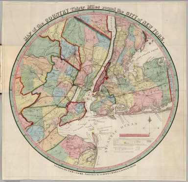
(Covers to) A Description Of The Cities, Townships, And Principal Villages And Settlements, Within Thirty Miles Of The City Of New-York ... Accompanied By A Correct Map. New-York: Published By Colton & Disturnell, No. 14 Broadway. M DCCC XXXIX. (on verso) Entered ...1839, by John Disturnell ... New-York. Sackett & Sargent, Printers, No. 1 Nassau street, cor. of Wall. (with) Map of the Country Thirty Miles round the City of New York. New Edition, 1839. New-York, Published by J. Disturnell. Drawn by I.H. Eddy.
List No
4922.001
Note
First edition of the guide book, fourth edition of the map after the 1811 first edition by Eddy (see our #3472). Changes from the 1811 edition include a Ten mile circle around the city, and the addition of numerous new towns, canals and railroads. Disturnell also published the map separately. Full color by township. Bound into brown cloth covers 15.5x10 with "30 Miles Around The City Of New-York With A Guide." in gilt.
Author
[Disturnell, John, Eddy, J.H.]
Full Title
(Title Page to) A Description Of The Cities, Townships, And Principal Villages And Settlements, Within Thirty Miles Of The City Of New-York ... Accompanied By A Correct Map. New-York: Published By Colton & Disturnell, No. 14 Broadway. M DCCC XXXIX. (on verso) Entered ...1839, by John Disturnell ... New-York. Sackett & Sargent, Printers, No. 1 Nassau street, cor. of Wall. (with) Map of the Country Thirty Miles round the City of New York. New Edition, 1839. New-York, Published by J. Disturnell. Drawn by I.H. Eddy.
List No
4922.002
Note
First edition of the guide book, fourth edition of the map after the 1811 first edition by Eddy (see our #3472). Changes from the 1811 edition include a Ten mile circle around the city, and the addition of numerous new towns, canals and railroads. Disturnell also published the map separately. Full color by township. Bound into brown cloth covers 15.5x10 with "30 Miles Around The City Of New-York With A Guide." in gilt.
Author
[Disturnell, John, Eddy, J.H.]
Full Title
Map of the Country Thirty Miles round the City of New York. New Edition, 1839. New-York, Published by J. Disturnell. Drawn by I.H. Eddy. (with) A Description Of The Cities, Townships, And Principal Villages And Settlements, Within Thirty Miles Of The City Of New-York ... Accompanied By A Correct Map. New-York: Published By Colton & Disturnell, No. 14 Broadway. M DCCC XXXIX. (on verso) Entered ...1839, by John Disturnell ... New-York. Sackett & Sargent, Printers, No. 1 Nassau street, cor. of Wall.
List No
4922.003
Note
First edition of the guide book, fourth edition of the map after the 1811 first edition by Eddy (see our #3472). Changes from the 1811 edition include a Ten mile circle around the city, and the addition of numerous new towns, canals and railroads. Disturnell also published the map separately. Full color by township. Bound into brown cloth covers 15.5x10 with "30 Miles Around The City Of New-York With A Guide." in gilt.
Author
[Disturnell, John, David H., 1803-1875]
Full Title
(Covers to) Guide To The Environs Of The City Of New York ... Accompanied By A Correct Map. Price 50 Cents. Published By J. Disturnell. 1836. (with) Map Of New-York and its Vicinity, Drawn by D.H. Burr, for New York as it is, in 1836. Published by J. Disturnell, No. 156 Broadway, New-York. Engraved by S. Stiles & Co. Merchs. Exch. N.Y. Entered ... 1834, by J. Disturnell ... New York.
List No
5128.001
Note
The map was first issued in 1834 for the Disturnell guide "New York as it is in 1834." Covers are brown leather with "Guide To The Environs Of New-York" stamped in gilt.
Author
[Disturnell, John, David H., 1803-1875]
Full Title
(Title page to) Guide To The Environs Of The City Of New York ... Accompanied By A Correct Map. Price 50 Cents. Published By J. Disturnell. 1836. (with) Map Of New-York and its Vicinity, Drawn by D.H. Burr, for New York as it is, in 1836. Published by J. Disturnell, No. 156 Broadway, New-York. Engraved by S. Stiles & Co. Merchs. Exch. N.Y. Entered ... 1834, by J. Disturnell ... New York.
List No
5128.002
Note
The map was first issued in 1834 for the Disturnell guide "New York as it is in 1834." Covers are brown leather with "Guide To The Environs Of New-York" stamped in gilt.
Author
[Disturnell, John, David H., 1803-1875]
Full Title
Guide To The Environs Of The City Of New York ... Accompanied By A Correct Map. Price 50 Cents. Published By J. Disturnell. 1836. (with) Map Of New-York and its Vicinity, Drawn by D.H. Burr, for New York as it is, in 1836. Published by J. Disturnell, No. 156 Broadway, New-York. Engraved by S. Stiles & Co. Merchs. Exch. N.Y. Entered ... 1834, by J. Disturnell ... New York.
List No
5128.003
Note
The map was first issued in 1834 for the Disturnell guide "New York as it is in 1834." Covers are brown leather with "Guide To The Environs Of New-York" stamped in gilt.
Author
Disturnell, John
Full Title
(Covers to) Mapa de los Estados Unidos de Mejico, segun lo organizado y definido por las varias actas del Congreso de dicha Republica ... Lo Publican J. Disturnell, 102 Broadway. Nueva York. 1846.
List No
5175A
Note
Red cloth covers 15x10 with "Mexico." stamped in gold.
Author
Disturnell, John
Full Title
(Text Page to) Mapa de los Estados Unidos de Mejico, segun lo organizado y definido por las varias actas del Congreso de dicha Republica ... Lo Publican J. Disturnell, 102 Broadway. Nueva York. 1846.
List No
5175B
Note
Inside front cover "Statistics of the Republic of Mexico."
Author
Disturnell, John
Full Title
Mapa de los Estados Unidos de Mejico, segun lo organizado y definido por las varias actas del Congreso de dicha Republica ... Lo Publican J. Disturnell, 102 Broadway. Nueva York. 1846. (inset) Carto de los caminos &c. desde Vera Cruz y Alvarado a Mejico.
List No
5175.001
Note
The first Disturnell edition, and the second Martin edition (after the 1828 White Gallaher and White first edition). Wheat calls this edition a "famous" map. This edition is distinguished by the absence of a trail line running directly from San Antonio to Austin, Texas, that appears on the third Martin edition. Compared to our seventh edition (see our # 2541), there are substantially fewer towns, roads, and physical features both in Mexico and the U.S. The two profiles in the Pacific and two inset maps in the Gulf of Mexico of the 1847 edition are not present. The covers and paste down statistics are the same as our 1847 edition. The map was printed from the same plate as the 1828 White Gallaher and White edition, evidenced by the faint copyright notice in the lower right corner under the neat line; Disturnell made many updates to the 1828 edition, and its republication by him was occasioned by the outbreak of the Mexican War. White Gallaher and White copied and slightly enlarged Henry Tanner's 1826 Map of the United States of Mexico (see our #5176). Martin lists twenty three editions of Disturnell's map. A significant difference between the Disturnell map and the earlier editions by White Gallaher and White, and Tanner, is the moving of the boundary line between Alta and Baja California about 70 miles further north toward San Diego, which was then used as the boundary in the treaty to end the Mexican War. Map is full color, folded into red cloth covers 15x10 with "Mexico." stamped in gold. Relief shown by hachures and spot heights. Prime meridian: Washington.
1-38 of 38
|